UKBOTA Bunker Planning Dashboard

💡 On this page you will find our UKBOTA map and the latest list. Scroll or swipe down to see the list in table format.

UKBOTA Universal Planning Map

Map mode:


Total Bunkers: 3419
Total Activated Bunkers: 2096
Total Activations: 5604
Total QSOs: 232848
Total B2B: 9729
My Activations: 0
My Activated Bunkers: 0
My Activator QSOs: 0
My B2B QSOs: 0
My Hunted Bunkers: 0
My Hunter QSOs: 0
Multiple markers
(click or zoom for more detail)

How to use the Planning Map

This bunker planning map shows all UK bunkers, it can be used to determine which bunkers have been activated, by and when, and also to show which bunkers are UKBOTA ATNO (‘All Time New Ones’), i.e. there is no record of a previous activation at this bunker. Note, this map is probably best used for planning an activation, for use during an activation we recommend the activation maps linked below. For clarity bunkers are shown as ‘hot spots’ until you ‘zoom’ in at which point they will be shown individually. 

Top left:
Zoom in and out: + and -, and Full Screen [  ] 

Top Right:
Controls:
* Select to view by year or Lifetime, ie. ‘All Time’
* Toggle Map / Satellite View
* Show bunkers activations and un-activated bunkers (ATNO)
* Show 1km range circles

Statistics: Show how many bunkers have been activated. Find: Search for a bunker (use the correct syntax!)

ℹ️ Note: To view your personalised Activator and Hunter maps, please log in to Bunkerbase 2 (BB2) first. Once logged in, your maps will appear on your Activator and Hunter dashboards.

Activation Maps

📍 The above map is great for planning. Whilst activating we recommend either the the M1SDH map (great for multi-scheme activations, eg. if activating UKBOTA and POTA at the same time), or the WWBOTA map. Both the M1SDH and WWBOTA have the added bonus of geolocation of your actual activating location. 

Google Map Overlay

📍 A Google Maps compatible file of current UKBOTA bunkers as a KMZ file can be found in our downloads area here.

Disclaimer

⚠️ Safety and Right of Access. Inclusion on our list does not mean that a bunker, including anywhere within the activation zone is either safe or legal to access. If in doubt activators are advised to seek permission from the landowner and conduct your own Risk Assessment. You are advised to follow all local signage regarding permissions, access, safety and site photography.

UKBOTA accepts no responsibility for issues arising from an activators activity.

UKBOTA Bunker List

×

BunkerNav

Reference: B/G-0001
Name: ROC Post Pavenham
Coord 52.18983, -0.58041
SP 9714 5557 | SP95 | IO92RE
Nearest Postcode: MK43 7NB
Navigation
From: Detecting location...
Reference: B/G-0002
Name: ROC Post Toddington
Coord 51.92689, -0.53375
TL 0092 2639 | TL02 | IO91RW
Nearest Postcode: LU5 6JL
Navigation
From: Detecting location...
Reference: B/G-0003
Name: ROC Post Ampthill
Coord 52.02972, -0.50298
TL 0280 3787 | TL03 | IO92RA
Nearest Postcode: MK45 2GT
Navigation
From: Detecting location...
Reference: B/G-0004
Name: ROC Post Riseley
Coord 52.25162, -0.46754
TL 0471 6260 | TL06 | IO92SG
Nearest Postcode: MK44 1DP
Navigation
From: Detecting location...
Reference: B/G-0005
Name: ROC Post Ravensden
Coord 52.16761, -0.41721
TL 0835 5333 | TL05 | IO92SE
Nearest Postcode: MK41 0JJ
Navigation
From: Detecting location...
Reference: B/G-0006
Name: ROC Post Sandy
Coord 52.13344, -0.31921
TL 1514 4968 | TL14 | IO92UD
Nearest Postcode: MK44 3DE
Navigation
From: Detecting location...
Reference: B/G-0007
Name: ROC Post Shefford
Coord 52.03247, -0.31367
TL 1578 3846 | TL13 | IO92UA
Nearest Postcode: SG17 5PT
Navigation
From: Detecting location...
Reference: B/G-0008
Name: ROC Post Ashbury Master Post
Coord 51.55945, -1.61019
SU 2712 8458 | SU28 | IO91EN
Nearest Postcode: SN6 8LZ
Navigation
From: Detecting location...
Reference: B/G-0009
Name: ROC Post Great Shefford
Coord 51.46301, -1.46001
SU 3761 7392 | SU37 | IO91GL
Nearest Postcode: RG17 7BP
Navigation
From: Detecting location...
Reference: B/G-0010
Name: ROC Post Wantage
Coord 51.58169, -1.41979
SU 4030 8714 | SU48 | IO91GN
Nearest Postcode: OX12 8PB
Navigation
From: Detecting location...
Reference: B/G-0011
Name: ROC Post Longworth
Coord 51.69382, -1.40504
SU 4122 9962 | SU49 | IO91HQ
Nearest Postcode: OX13 5LT
Navigation
From: Detecting location...
Reference: B/G-0012
Name: ROC Post Newbury
Coord 51.38352, -1.35274
SU 4514 6514 | SU46 | IO91HJ
Nearest Postcode: RG14 6RD
Navigation
From: Detecting location...
Reference: B/G-0013
Name: ROC Post East Ilsley
Coord 51.52334, -1.30493
SU 4832 8072 | SU48 | IO91IM
Nearest Postcode: RG20 7DJ
Navigation
From: Detecting location...
Reference: B/G-0014
Name: ROC Post Cold Ash
Coord 51.42070, -1.25457
SU 5193 6934 | SU56 | IO91IK
Nearest Postcode: RG18 9HT
Navigation
From: Detecting location...
Reference: B/G-0015
Name: ROC Post Streatley Master Post
Coord 51.51619, -1.17389
SU 5742 8002 | SU58 | IO91JM
Nearest Postcode: RG8 9RE
Navigation
From: Detecting location...
Reference: B/G-0016
Name: ROC Post Bradfield
Coord 51.43696, -1.13432
SU 6027 7124 | SU67 | IO91KK
Nearest Postcode: RG7 6AD
Navigation
From: Detecting location...
Reference: B/G-0017
Name: ROC Post Arborfield
Coord 51.39032, -0.91128
SU 7585 6626 | SU76 | IO91NJ
Nearest Postcode: RG2 9JS
Navigation
From: Detecting location...
Reference: B/G-0018
Name: ROC Post Shurlock Row
Coord 51.46563, -0.82268
SU 8188 7473 | SU87 | IO91OL
Nearest Postcode: RG10 0PJ
Navigation
From: Detecting location...
Reference: B/G-0019
Name: ROC Post Crowthorne
Coord 51.37256, -0.78757
SU 8449 6442 | SU86 | IO91OI
Nearest Postcode: RG45 6SR
Navigation
From: Detecting location...
Reference: B/G-0020
Name: ROC Post Ascot
Coord 51.41675, -0.67438
SU 9228 6947 | SU96 | IO91PK
Nearest Postcode: SL5 7LJ
Navigation
From: Detecting location...
Reference: B/G-0021
Name: ROC Post Windsor
Coord 51.48451, -0.60156
SU 9720 7710 | SU97 | IO91QL
Nearest Postcode: SL4 1QE
Navigation
From: Detecting location...
Reference: B/G-0022
Name: ROC Post Buckingham
Coord 51.98472, -0.97775
SP 7030 3230 | SP73 | IO91MX
Nearest Postcode: MK18 1SZ
Navigation
From: Detecting location...
Reference: B/G-0023
Name: ROC Post Stony Stratford
Coord 52.06466, -0.87089
SP 7750 4130 | SP74 | IO92NB
Nearest Postcode: MK19 6FL
Navigation
From: Detecting location...
Reference: B/G-0024
Name: ROC Post Whitchurch
Coord 51.88219, -0.84743
SP 7943 2103 | SP72 | IO91NV
Nearest Postcode: HP22 4JJ
Navigation
From: Detecting location...
Reference: B/G-0025
Name: ROC Post Princes Risborough
Coord 51.70831, -0.84071
SP 8020 0170 | SP80 | IO91NQ
Nearest Postcode: HP27 9NL
Navigation
From: Detecting location...
Reference: B/G-0026
Name: ROC Post Weston Turville
Coord 51.80016, -0.76555
SP 8522 1200 | SP81 | IO91OT
Nearest Postcode: HP22 5QY
Navigation
From: Detecting location...
Reference: B/G-0027
Name: ROC Post Bletchley
Coord 51.98225, -0.72444
SP 8770 3230 | SP83 | IO91PX
Nearest Postcode: MK2 3DS
Navigation
From: Detecting location...
Reference: B/G-0028
Name: ROC Post Olney Master Post
Coord 52.10246, -0.69985
SP 8915 4570 | SP84 | IO92PC
Nearest Postcode: MK16 9NN
Navigation
From: Detecting location...
Reference: B/G-0029
Name: ROC Post Cheddington
Coord 51.84412, -0.67391
SP 9145 1700 | SP91 | IO91PU
Nearest Postcode: LU7 0RS
Navigation
From: Detecting location...
Reference: B/G-0030
Name: ROC Post Great Missenden
Coord 51.71022, -0.66481
SP 9235 0212 | SP90 | IO91QR
Nearest Postcode: HP16 0RW
Navigation
From: Detecting location...
Reference: B/G-0031
Name: ROC Post Marlow
Coord 51.57496, -0.76935
SU 8538 8695 | SU88 | IO91ON
Nearest Postcode: SL7 1HF
Navigation
From: Detecting location...
Reference: B/G-0032
Name: ROC Post Beaconsfield
Coord 51.59533, -0.66673
SU 9245 8934 | SU98 | IO91PO
Nearest Postcode: HP9 1XD
Navigation
From: Detecting location...
Reference: B/G-0033
Name: ROC Post Parson Drove
Coord 52.66693, 0.03808
TF 3792 0964 | TF30 | JO02AQ
Nearest Postcode: PE13 4LD
Navigation
From: Detecting location...
Reference: B/G-0034
Name: ROC Post Whittlesey
Coord 52.56574, -0.10561
TL 2850 9812 | TL29 | IO92WN
Nearest Postcode: PE7 1YZ
Navigation
From: Detecting location...
Reference: B/G-0035
Name: ROC Post Caxton
Coord 52.21557, -0.09727
TL 3009 5919 | TL35 | IO92WF
Nearest Postcode: CB23 3PG
Navigation
From: Detecting location...
Reference: B/G-0036
Name: ROC Post Arrington
Coord 52.13441, -0.07121
TL 3211 5021 | TL35 | IO92XD
Nearest Postcode: SG8 0BG
Navigation
From: Detecting location...
Reference: B/G-0037
Name: ROC Post Benwick
Coord 52.48073, -0.03121
TL 3380 8880 | TL38 | IO92XL
Nearest Postcode: PE26 2XT
Navigation
From: Detecting location...
Reference: B/G-0038
Name: ROC Post March
Coord 52.53431, 0.06938
TL 4046 9495 | TL49 | JO02AM
Nearest Postcode: PE15 9QD
Navigation
From: Detecting location...
Reference: B/G-0039
Name: ROC Post Willingham
Coord 52.26550, 0.06710
TL 4116 6505 | TL46 | JO02AG
Nearest Postcode: CB24 3AT
Navigation
From: Detecting location...
Reference: B/G-0040
Name: ROC Post Harston
Coord 52.12957, 0.09090
TL 4322 4998 | TL44 | JO02BD
Nearest Postcode: CB22 7NZ
Navigation
From: Detecting location...
Reference: B/G-0041
Name: ROC Post Sutton Master Post
Coord 52.38099, 0.11584
TL 4411 7799 | TL47 | JO02BJ
Nearest Postcode: CB6 2PD
Navigation
From: Detecting location...
Reference: B/G-0042
Name: ROC Post Manea
Coord 52.47813, 0.16895
TL 4740 8890 | TL48 | JO02CL
Nearest Postcode: PE15 0US
Navigation
From: Detecting location...
Reference: B/G-0043
Name: ROC Post Cherry Hinton
Coord 52.16930, 0.18109
TL 4926 5458 | TL45 | JO02CE
Nearest Postcode: CB21 5EQ
Navigation
From: Detecting location...
Reference: B/G-0044
Name: ROC Post Stretham
Coord 52.35159, 0.21884
TL 5122 7493 | TL57 | JO02CI
Nearest Postcode: CB6 3JH
Navigation
From: Detecting location...
Reference: B/G-0045
Name: ROC Post Linton
Coord 52.09503, 0.26696
TL 5539 4650 | TL54 | JO02DC
Nearest Postcode: CB21 4NW
Navigation
From: Detecting location...
Reference: B/G-0046
Name: ROC Post Bottisham
Coord 52.23670, 0.28311
TL 5600 6229 | TL56 | JO02DF
Nearest Postcode: CB25 0LU
Navigation
From: Detecting location...
Reference: B/G-0047
Name: ROC Post Littleport
Coord 52.44275, 0.29934
TL 5638 8524 | TL58 | JO02DK
Nearest Postcode: CB6 1HP
Navigation
From: Detecting location...
Reference: B/G-0048
Name: ROC Post Fordham
Coord 52.37107, 0.35042
TL 6011 7738 | TL67 | JO02EI
Nearest Postcode: CB7 5UG
Navigation
From: Detecting location...
Reference: B/G-0049
Name: ROC Post Caldy
Coord 53.38110, -3.14535
SJ 2391 8775 | SJ28 | IO83KJ
Nearest Postcode: CH48 1PQ
Navigation
From: Detecting location...
Reference: B/G-0050
Name: ROC Post Neston
Coord 53.30907, -3.02981
SJ 3148 7962 | SJ37 | IO83LH
Nearest Postcode: CH63 4JJ
Navigation
From: Detecting location...
Reference: B/G-0051
Name: ROC Post Saughall
Coord 53.21705, -2.95017
SJ 3665 6931 | SJ36 | IO83MF
Nearest Postcode: CH1 6AG
Navigation
From: Detecting location...
Reference: B/G-0052
Name: ROC Post Aldford
Coord 53.12155, -2.87231
SJ 4172 5862 | SJ45 | IO83NC
Nearest Postcode: CH3 6HT
Navigation
From: Detecting location...
Reference: B/G-0053
Name: ROC Post Helsby Master Post
Coord 53.27350, -2.76263
SJ 4924 7544 | SJ47 | IO83OG
Nearest Postcode: WA6 9PL
Navigation
From: Detecting location...
Reference: B/G-0054
Name: ROC Post Malpas
Coord 53.02644, -2.75513
SJ 4945 4795 | SJ44 | IO83OA
Nearest Postcode: SY14 8DQ
Navigation
From: Detecting location...
Reference: B/G-0055
Name: ROC Post Tarporley
Coord 53.16985, -2.69018
SJ 5396 6386 | SJ56 | IO83PE
Nearest Postcode: CW6 0EF
Navigation
From: Detecting location...
Reference: B/G-0056
Name: ROC Post Preston on the Hill
Coord 53.33226, -2.64565
SJ 5710 8190 | SJ58 | IO83QH
Nearest Postcode: WA4 4BS
Navigation
From: Detecting location...
Reference: B/G-0057
Name: ROC Post Faddiley
Coord 53.07380, -2.61745
SJ 5873 5313 | SJ55 | IO83QB
Nearest Postcode: CW5 8JE
Navigation
From: Detecting location...
Reference: B/G-0058
Name: ROC Post Audlem
Coord 52.99989, -2.50657
SJ 6610 4485 | SJ64 | IO82RX
Nearest Postcode: CW3 0HF
Navigation
From: Detecting location...
Reference: B/G-0059
Name: ROC Post Northwich
Coord 53.24625, -2.49180
SJ 6728 7225 | SJ67 | IO83SF
Nearest Postcode: CW9 7NY
Navigation
From: Detecting location...
Reference: B/G-0060
Name: ROC Post Middlewich
Coord 53.19289, -2.43775
SJ 7085 6629 | SJ76 | IO83SE
Nearest Postcode: CW10 0HU
Navigation
From: Detecting location...
Reference: B/G-0061
Name: ROC Post Altrincham
Coord 53.39516, -2.43050
SJ 7147 8879 | SJ78 | IO83SJ
Nearest Postcode: WA13 9UT
Navigation
From: Detecting location...
Reference: B/G-0062
Name: ROC Post Crewe
Coord 53.06523, -2.41616
SJ 7221 5208 | SJ75 | IO83TB
Nearest Postcode: CW2 5LX
Navigation
From: Detecting location...
Reference: B/G-0063
Name: ROC Post Knutsford
Coord 53.31138, -2.37908
SJ 7484 7945 | SJ77 | IO83TH
Nearest Postcode: WA16 6SZ
Navigation
From: Detecting location...
Reference: B/G-0064
Name: ROC Post Sandbach
Coord 53.15532, -2.35467
SJ 7638 6208 | SJ76 | IO83TD
Nearest Postcode: CW11 4TE
Navigation
From: Detecting location...
Reference: B/G-0065
Name: ROC Post Macclesfield
Coord 53.25000, -2.11401
SJ 9249 7256 | SJ97 | IO83WG
Nearest Postcode: SK11 7HA
Navigation
From: Detecting location...
Reference: B/G-0066
Name: ROC Post Poynton
Coord 53.34044, -2.10359
SJ 9320 8262 | SJ98 | IO83WI
Nearest Postcode: SK12 1FR
Navigation
From: Detecting location...
Reference: B/G-0067
Name: ROC Post Hyde
Coord 53.43017, -2.06498
SJ 9578 9260 | SJ99 | IO83XK
Nearest Postcode: SK14 3AA
Navigation
From: Detecting location...
Reference: B/G-0068
Name: ROC Post Kilkhampton Master Post
Coord 50.89375, -4.47822
SS 2581 1340 | SS21 | IO70SV
Nearest Postcode: EX23 9RJ
Navigation
From: Detecting location...
Reference: B/G-0069
Name: ROC Post Sennen
Coord 50.07100, -5.69236
SW 3589 2552 | SW32 | IO70DB
Nearest Postcode: TR19 7AD
Navigation
From: Detecting location...
Reference: B/G-0070
Name: ROC Post Madron Master Post
Coord 50.14646, -5.58701
SW 4383 3354 | SW43 | IO70ED
Nearest Postcode: TR20 8NZ
Navigation
From: Detecting location...
Reference: B/G-0071
Name: ROC Post St. Ives - Cornwall
Coord 50.18999, -5.47228
SW 5225 3799 | SW53 | IO70GE
Nearest Postcode: TR26 3HP
Navigation
From: Detecting location...
Reference: B/G-0072
Name: ROC Post Helston
Coord 50.09888, -5.28932
SW 6486 2727 | SW62 | IO70IC
Nearest Postcode: TR13 0FD
Navigation
From: Detecting location...
Reference: B/G-0073
Name: ROC Post Praze-An-Beeble
Coord 50.18407, -5.26071
SW 6732 3665 | SW63 | IO70IE
Nearest Postcode: TR14 9JG
Navigation
From: Detecting location...
Reference: B/G-0074
Name: ROC Post The Lizard
Coord 49.96487, -5.19133
SW 7123 1207 | SW71 | IN79JX
Nearest Postcode: TR12 7AP
Navigation
From: Detecting location...
Reference: B/G-0075
Name: ROC Post Constantine
Coord 50.12479, -5.19272
SW 7189 2985 | SW72 | IO70JC
Nearest Postcode: TR11 5QF
Navigation
From: Detecting location...
Reference: B/G-0076
Name: ROC Post St. Agnes
Coord 50.29392, -5.19225
SW 7273 4865 | SW74 | IO70JH
Nearest Postcode: TR5 0PF
Navigation
From: Detecting location...
Reference: B/G-0077
Name: ROC Post Penryn Master Post
Coord 50.17524, -5.14048
SW 7586 3530 | SW73 | IO70KE
Nearest Postcode: TR10 9DH
Navigation
From: Detecting location...
Reference: B/G-0078
Name: ROC Post Truro
Coord 50.25285, -5.05396
SW 8239 4367 | SW84 | IO70LG
Nearest Postcode: TR1 2HN
Navigation
From: Detecting location...
Reference: B/G-0079
Name: ROC Post Mitchell
Coord 50.34340, -5.03475
SW 8417 5368 | SW85 | IO70LI
Nearest Postcode: TR4 9JD
Navigation
From: Detecting location...
Reference: B/G-0080
Name: ROC Post Newquay
Coord 50.43493, -5.02948
SW 8496 6384 | SW86 | IO70LK
Nearest Postcode: TR8 4AW
Navigation
From: Detecting location...
Reference: B/G-0081
Name: ROC Post St Anthony-in-Meneage
Coord 50.15391, -4.99823
SW 8592 3251 | SW83 | IO70MD
Nearest Postcode: TR2 5EY
Navigation
From: Detecting location...
Reference: B/G-0082
Name: ROC Post Veryan
Coord 50.19991, -4.91548
SW 9203 3739 | SW93 | IO70NE
Nearest Postcode: TR2 5PQ
Navigation
From: Detecting location...
Reference: B/G-0083
Name: ROC Post St. Columb Major Master Post
Coord 50.42393, -4.92500
SW 9233 6232 | SW96 | IO70MK
Nearest Postcode: TR9 6JS
Navigation
From: Detecting location...
Reference: B/G-0084
Name: ROC Post Trebetherick
Coord 50.58397, -4.90668
SW 9430 8000 | SW98 | IO70NO
Nearest Postcode: PL27 6QY
Navigation
From: Detecting location...
Reference: B/G-0085
Name: ROC Post Nanpean
Coord 50.35078, -4.84923
SW 9740 5399 | SW95 | IO70NI
Nearest Postcode: PL26 7TR
Navigation
From: Detecting location...
Reference: B/G-0086
Name: ROC Post Mevagissey
Coord 50.24717, -4.79702
SX 0068 4232 | SX04 | IO70OF
Nearest Postcode: PL26 6NS
Navigation
From: Detecting location...
Reference: B/G-0087
Name: ROC Post Tintagel
Coord 50.66282, -4.75996
SX 0504 8843 | SX08 | IO70OP
Nearest Postcode: PL34 0DL
Navigation
From: Detecting location...
Reference: B/G-0088
Name: ROC Post Bodmin
Coord 50.46479, -4.72403
SX 0677 6632 | SX06 | IO70PL
Nearest Postcode: PL31 1BH
Navigation
From: Detecting location...
Reference: B/G-0089
Name: ROC Post St. Breward Master Post
Coord 50.56647, -4.68794
SX 0974 7753 | SX07 | IO70PN
Nearest Postcode: PL30 4PP
Navigation
From: Detecting location...
Reference: B/G-0090
Name: ROC Post Par
Coord 50.36911, -4.66889
SX 1030 5554 | SX15 | IO70PI
Nearest Postcode: PL24 2UA
Navigation
From: Detecting location...
Reference: B/G-0091
Name: ROC Post Otterham
Coord 50.66617, -4.62273
SX 1475 8845 | SX18 | IO70QP
Nearest Postcode: PL35 0HS
Navigation
From: Detecting location...
Reference: B/G-0092
Name: ROC Post Polperro
Coord 50.36688, -4.51858
SX 2098 5492 | SX25 | IO70RI
Nearest Postcode: PL13 2PQ
Navigation
From: Detecting location...
Reference: B/G-0093
Name: ROC Post Week St. Mary
Coord 50.75790, -4.50506
SX 2341 9836 | SX29 | IO70RS
Nearest Postcode: EX22 6XF
Navigation
From: Detecting location...
Reference: B/G-0094
Name: ROC Post Liskeard
Coord 50.45589, -4.45751
SX 2565 6467 | SX26 | IO70SK
Nearest Postcode: PL14 3BS
Navigation
From: Detecting location...
Reference: B/G-0095
Name: ROC Post Coad's Green
Coord 50.56661, -4.40155
SX 3002 7685 | SX37 | IO70TN
Nearest Postcode: PL15 7LU
Navigation
From: Detecting location...
Reference: B/G-0096
Name: ROC Post Downderry
Coord 50.36800, -4.37154
SX 3144 5470 | SX35 | IO70TI
Nearest Postcode: PL11 3DJ
Navigation
From: Detecting location...
Reference: B/G-0097
Name: ROC Post Launceston
Coord 50.63239, -4.35626
SX 3346 8406 | SX38 | IO70TP
Nearest Postcode: PL15 9BQ
Navigation
From: Detecting location...
Reference: B/G-0098
Name: ROC Post Callington
Coord 50.49909, -4.30237
SX 3681 6912 | SX36 | IO70UL
Nearest Postcode: PL17 7PY
Navigation
From: Detecting location...
Reference: B/G-0099
Name: ROC Post Saltash
Coord 50.40627, -4.25621
SX 3977 5870 | SX35 | IO70UJ
Nearest Postcode: PL12 4QH
Navigation
From: Detecting location...
Reference: B/G-0100
Name: ROC Post Millbrook Master Post
Coord 50.34269, -4.20428
SX 4325 5152 | SX45 | IO70VI
Nearest Postcode: PL10 1LA
Navigation
From: Detecting location...
Reference: B/G-0101
Name: ROC Post Wadebridge
Coord 50.50952, -4.89445
SW 9487 7175 | SW97 | IO70NM
Nearest Postcode: PL27 7RQ
Navigation
From: Detecting location...
Reference: B/G-0103
Name: ROC Post Sacriston Master Post
Coord 54.82618, -1.65529
NZ 2225 4798 | NZ24 | IO94ET
Nearest Postcode: DH7 6TT
Navigation
From: Detecting location...
Reference: B/G-0104
Name: ROC Post Stanhope
Coord 54.76007, -2.01551
NY 9910 4057 | NY94 | IO84XS
Nearest Postcode: DL13 2EW
Navigation
From: Detecting location...
Reference: B/G-0105
Name: ROC Post Woodland
Coord 54.61473, -1.92394
NZ 0501 2440 | NZ02 | IO94AO
Nearest Postcode: DL13 5RU
Navigation
From: Detecting location...
Reference: B/G-0106
Name: ROC Post Tow Law Master Post
Coord 54.74075, -1.79308
NZ 1342 3844 | NZ13 | IO94CR
Nearest Postcode: DL13 4NH
Navigation
From: Detecting location...
Reference: B/G-0107
Name: ROC Post Tantobie
Coord 54.88605, -1.73996
NZ 1678 5462 | NZ15 | IO94DV
Nearest Postcode: DH9 9SH
Navigation
From: Detecting location...
Reference: B/G-0108
Name: ROC Post Westerton
Coord 54.67546, -1.62174
NZ 2449 3122 | NZ23 | IO94EQ
Nearest Postcode: DL16 7QD
Navigation
From: Detecting location...
Reference: B/G-0109
Name: ROC Post Springwell
Coord 54.92497, -1.55590
NZ 2856 5901 | NZ25 | IO94FW
Nearest Postcode: NE9 7YX
Navigation
From: Detecting location...
Reference: B/G-0110
Name: ROC Post Sherburn Hill
Coord 54.76994, -1.48455
NZ 3326 4179 | NZ34 | IO94GS
Nearest Postcode: DH6 1QR
Navigation
From: Detecting location...
Reference: B/G-0111
Name: ROC Post Sadberge
Coord 54.54336, -1.47875
NZ 3382 1658 | NZ31 | IO94GN
Nearest Postcode: DL2 1TW
Navigation
From: Detecting location...
Reference: B/G-0112
Name: ROC Post Sedgefield
Coord 54.66530, -1.43611
NZ 3647 3017 | NZ33 | IO94GP
Nearest Postcode: TS21 3ED
Navigation
From: Detecting location...
Reference: B/G-0113
Name: ROC Post Whitburn
Coord 54.95675, -1.36645
NZ 4067 6264 | NZ46 | IO94HW
Nearest Postcode: SR6 7LN
Navigation
From: Detecting location...
Reference: B/G-0114
Name: ROC Post Wolviston
Coord 54.60857, -1.30978
NZ 4468 2393 | NZ42 | IO94IO
Nearest Postcode: TS22 5EB
Navigation
From: Detecting location...
Reference: B/G-0115
Name: ROC Post Seaton Carew
Coord 54.64619, -1.18615
NZ 5262 2820 | NZ52 | IO94JP
Nearest Postcode: TS25 1DE
Navigation
From: Detecting location...
Reference: B/G-0116
Name: ROC Post Wearhead
Coord 54.74352, -2.22772
NY 8544 3875 | NY83 | IO84VR
Nearest Postcode: DL13 1HL
Navigation
From: Detecting location...
Reference: B/G-0117
Name: ROC Post Whitehaven
Coord 54.55497, -3.56923
NX 9861 1888 | NX91 | IO84FN
Nearest Postcode: CA28 6SH
Navigation
From: Detecting location...
Reference: B/G-0118
Name: ROC Post Workington
Coord 54.65185, -3.53514
NY 0105 2961 | NY02 | IO84FP
Nearest Postcode: CA14 1DG
Navigation
From: Detecting location...
Reference: B/G-0119
Name: ROC Post Seascale
Coord 54.40187, -3.48665
NY 0359 0173 | NY00 | IO84GJ
Nearest Postcode: CA20 1QN
Navigation
From: Detecting location...
Reference: B/G-0120
Name: ROC Post Allonby Master Post
Coord 54.77338, -3.42252
NY 0859 4298 | NY04 | IO84GS
Nearest Postcode: CA15 6QB
Navigation
From: Detecting location...
Reference: B/G-0121
Name: ROC Post Silloth
Coord 54.86577, -3.39164
NY 1078 5322 | NY15 | IO84HU
Nearest Postcode: CA7 4BL
Navigation
From: Detecting location...
Reference: B/G-0122
Name: ROC Post Cockermouth
Coord 54.68262, -3.36676
NY 1198 3281 | NY13 | IO84HQ
Nearest Postcode: CA13 0NY
Navigation
From: Detecting location...
Reference: B/G-0123
Name: ROC Post Kirkbride
Coord 54.91324, -3.20515
NY 2284 5828 | NY25 | IO84JV
Nearest Postcode: CA7 5AA
Navigation
From: Detecting location...
Reference: B/G-0124
Name: ROC Post Bassenthwaite
Coord 54.68460, -3.19728
NY 2291 3283 | NY23 | IO84JQ
Nearest Postcode: CA12 4RJ
Navigation
From: Detecting location...
Reference: B/G-0125
Name: ROC Post Wigton
Coord 54.83219, -3.16739
NY 2511 4922 | NY24 | IO84JT
Nearest Postcode: CA7 9DH
Navigation
From: Detecting location...
Reference: B/G-0126
Name: ROC Post Threlkeld
Coord 54.60991, -3.07245
NY 3083 2439 | NY32 | IO84LO
Nearest Postcode: CA12 4RR
Navigation
From: Detecting location...
Reference: B/G-0127
Name: ROC Post Caldbeck
Coord 54.74294, -3.02952
NY 3382 3915 | NY33 | IO84LR
Nearest Postcode: CA7 8JJ
Navigation
From: Detecting location...
Reference: B/G-0128
Name: ROC Post Dalston
Coord 54.82649, -2.96658
NY 3800 4839 | NY34 | IO84MT
Nearest Postcode: CA5 7AG
Navigation
From: Detecting location...
Reference: B/G-0129
Name: ROC Post Carlisle
Coord 54.92367, -2.96313
NY 3837 5920 | NY35 | IO84MW
Nearest Postcode: CA6 4SQ
Navigation
From: Detecting location...
Reference: B/G-0130
Name: ROC Post Greystoke
Coord 54.67075, -2.85883
NY 4471 3097 | NY43 | IO84NQ
Nearest Postcode: CA11 0UH
Navigation
From: Detecting location...
Reference: B/G-0131
Name: ROC Post Armathwaite
Coord 54.80856, -2.80107
NY 4861 4626 | NY44 | IO84OT
Nearest Postcode: CA4 9TH
Navigation
From: Detecting location...
Reference: B/G-0132
Name: ROC Post Penrith Master Post
Coord 54.65463, -2.77014
NY 5041 2911 | NY52 | IO84OP
Nearest Postcode: CA11 0DR
Navigation
From: Detecting location...
Reference: B/G-0133
Name: ROC Post Roadhead Master Post
Coord 55.06542, -2.75390
NY 5195 7481 | NY57 | IO85OB
Nearest Postcode: CA6 6NP
Navigation
From: Detecting location...
Reference: B/G-0134
Name: ROC Post Brampton
Coord 54.93515, -2.73491
NY 5301 6030 | NY56 | IO84PW
Nearest Postcode: CA8 1QJ
Navigation
From: Detecting location...
Reference: B/G-0135
Name: ROC Post Culgaith
Coord 54.65892, -2.59971
NY 6141 2948 | NY62 | IO84QP
Nearest Postcode: CA10 1DN
Navigation
From: Detecting location...
Reference: B/G-0136
Name: ROC Post Alston
Coord 54.80998, -2.43282
NY 7228 4621 | NY74 | IO84ST
Nearest Postcode: CA9 3TQ
Navigation
From: Detecting location...
Reference: B/G-0137
Name: ROC Post Bootle
Coord 54.29118, -3.37742
SD 1044 8927 | SD18 | IO84HG
Nearest Postcode: LA19 5TJ
Navigation
From: Detecting location...
Reference: B/G-0138
Name: ROC Post Eskdale
Coord 54.38926, -3.33321
NY 1252 0012 | NY10 | IO84IJ
Nearest Postcode: CA19 1TD
Navigation
From: Detecting location...
Reference: B/G-0139
Name: ROC Post Millom
Coord 54.20084, -3.26342
SD 1768 7908 | SD17 | IO84IE
Nearest Postcode: LA18 4JY
Navigation
From: Detecting location...
Reference: B/G-0140
Name: ROC Post Sedbergh
Coord 54.32506, -2.52134
SD 6619 9229 | SD69 | IO84RH
Nearest Postcode: LA10 5AN
Navigation
From: Detecting location...
Reference: B/G-0141
Name: ROC Post Glossop
Coord 53.44806, -1.93522
SK 0440 9459 | SK09 | IO93AK
Nearest Postcode: SK13 7TL
Navigation
From: Detecting location...
Reference: B/G-0142
Name: ROC Post Buxton Master Post
Coord 53.27767, -1.86994
SK 0877 7564 | SK07 | IO93BG
Nearest Postcode: SK17 8AE
Navigation
From: Detecting location...
Reference: B/G-0143
Name: ROC Post Uttoxeter Master Post
Coord 52.92166, -1.83531
SK 1117 3604 | SK13 | IO92BW
Nearest Postcode: DE6 5LN
Navigation
From: Detecting location...
Reference: B/G-0144
Name: ROC Post Hartington
Coord 53.13655, -1.80803
SK 1294 5995 | SK15 | IO93CD
Nearest Postcode: SK17 0AT
Navigation
From: Detecting location...
Reference: B/G-0145
Name: ROC Post Hope
Coord 53.31351, -1.79148
SK 1399 7964 | SK17 | IO93CH
Nearest Postcode: SK17 8JD
Navigation
From: Detecting location...
Reference: B/G-0146
Name: ROC Post Brassington
Coord 53.09380, -1.66113
SK 2279 5523 | SK25 | IO93EC
Nearest Postcode: DE4 4HN
Navigation
From: Detecting location...
Reference: B/G-0147
Name: ROC Post Baslow
Coord 53.24682, -1.64135
SK 2403 7226 | SK27 | IO93EF
Nearest Postcode: DE45 1RL
Navigation
From: Detecting location...
Reference: B/G-0148
Name: ROC Post Church Gresley
Coord 52.75772, -1.58758
SK 2793 1787 | SK21 | IO92ES
Nearest Postcode: DE11 9ES
Navigation
From: Detecting location...
Reference: B/G-0149
Name: ROC Post Hulland
Coord 53.01436, -1.58470
SK 2796 4642 | SK24 | IO93EA
Nearest Postcode: DE56 2LT
Navigation
From: Detecting location...
Reference: B/G-0150
Name: ROC Post Etwall
Coord 52.88625, -1.58146
SK 2826 3217 | SK23 | IO92FV
Nearest Postcode: DE65 6HY
Navigation
From: Detecting location...
Reference: B/G-0151
Name: ROC Post Ambergate Master Post
Coord 53.05581, -1.47300
SK 3542 5108 | SK35 | IO93GB
Nearest Postcode: DE56 2GS
Navigation
From: Detecting location...
Reference: B/G-0152
Name: ROC Post Ashover Master Post
Coord 53.16886, -1.46533
SK 3584 6366 | SK36 | IO93GE
Nearest Postcode: S45 0BB
Navigation
From: Detecting location...
Reference: B/G-0153
Name: ROC Post Melbourne
Coord 52.82104, -1.45996
SK 3649 2497 | SK32 | IO92GT
Nearest Postcode: DE73 7NF
Navigation
From: Detecting location...
Reference: B/G-0154
Name: DELETED after 28 Feb 25, (dupe with B/G-0151)
Coord 53.05033, -1.42563
SK 3856 5050 | SK35 | IO93GB
Nearest Postcode: DELETED
Navigation
From: Detecting location...
Reference: B/G-0155
Name: ROC Post Spondon
Coord 52.93686, -1.39335
SK 4087 3789 | SK43 | IO92HW
Nearest Postcode: DE21 7BW
Navigation
From: Detecting location...
Reference: B/G-0156
Name: ROC Post Staveley
Coord 53.27839, -1.34789
SK 4358 7591 | SK47 | IO93HG
Nearest Postcode: S43 3YG
Navigation
From: Detecting location...
Reference: B/G-0157
Name: ROC Post Whitwell
Coord 53.28688, -1.20750
SK 5293 7695 | SK57 | IO93JG
Nearest Postcode: S80 4SS
Navigation
From: Detecting location...
Reference: B/G-0160
Name: ROC Post Holsworthy
Coord 50.81073, -4.34350
SS 3499 0386 | SS30 | IO70TT
Nearest Postcode: EX22 6JN
Navigation
From: Detecting location...
Reference: B/G-0161
Name: ROC Post Horns Cross
Coord 50.98890, -4.31627
SS 3753 2361 | SS32 | IO70UX
Nearest Postcode: EX39 5EA
Navigation
From: Detecting location...
Reference: B/G-0162
Name: ROC Post Woolacombe
Coord 51.16270, -4.16864
SS 4846 4262 | SS44 | IO71VD
Nearest Postcode: EX34 7HN
Navigation
From: Detecting location...
Reference: B/G-0163
Name: ROC Post Great Torrington
Coord 50.99703, -4.09535
SS 5306 2405 | SS52 | IO70WX
Nearest Postcode: EX31 3PS
Navigation
From: Detecting location...
Reference: B/G-0165
Name: ROC Post Hatherleigh
Coord 50.84523, -4.06936
SS 5441 0712 | SS50 | IO70XU
Nearest Postcode: EX20 3QB
Navigation
From: Detecting location...
Reference: B/G-0166
Name: ROC Post Shirwell
Coord 51.14421, -4.05225
SS 5654 4033 | SS54 | IO71XD
Nearest Postcode: EX31 4HS
Navigation
From: Detecting location...
Reference: B/G-0167
Name: ROC Post High Bickington
Coord 50.96514, -3.99080
SS 6030 2030 | SS62 | IO80AX
Nearest Postcode: EX37 9EJ
Navigation
From: Detecting location...
Reference: B/G-0168
Name: ROC Post Winkleigh Master Post
Coord 50.86786, -3.96249
SS 6200 0943 | SS60 | IO80AU
Nearest Postcode: EX19 8EZ
Navigation
From: Detecting location...
Reference: B/G-0169
Name: ROC Post South Molton
Coord 51.00580, -3.83631
SS 7126 2454 | SS72 | IO81BA
Nearest Postcode: EX36 4LB
Navigation
From: Detecting location...
Reference: B/G-0170
Name: ROC Post Witheridge
Coord 50.88827, -3.75391
SS 7673 1133 | SS71 | IO80CV
Nearest Postcode: EX17 4TH
Navigation
From: Detecting location...
Reference: B/G-0171
Name: ROC Post Stockleigh Pomeroy Master Post
Coord 50.81696, -3.58372
SS 8853 0313 | SS80 | IO80ET
Nearest Postcode: EX17 1BE
Navigation
From: Detecting location...
Reference: B/G-0172
Name: ROC Post Tiverton
Coord 50.89410, -3.52449
SS 9288 1162 | SS91 | IO80FV
Nearest Postcode: EX16 8JR
Navigation
From: Detecting location...
Reference: B/G-0173
Name: ROC Post Kentisbeare
Coord 50.85472, -3.34788
ST 0522 0700 | ST00 | IO80HU
Nearest Postcode: EX15 2BU
Navigation
From: Detecting location...
Reference: B/G-0174
Name: ROC Post Feniton
Coord 51.15581, -3.28257
ST 1040 4040 | ST14 | IO81ID
Nearest Postcode: TA4 4ED
Navigation
From: Detecting location...
Reference: B/G-0175
Name: ROC Post Tavistock
Coord 50.57495, -4.15466
SX 4753 7724 | SX47 | IO70WN
Nearest Postcode: PL19 0JN
Navigation
From: Detecting location...
Reference: B/G-0176
Name: ROC Post Sharpitor
Coord 50.51222, -4.03727
SX 5565 7003 | SX57 | IO70XM
Nearest Postcode: PL20 6PE
Navigation
From: Detecting location...
Reference: B/G-0177
Name: ROC Post Holbeton
Coord 50.32282, -3.96313
SX 6035 4883 | SX64 | IO80AH
Nearest Postcode: PL8 1JQ
Navigation
From: Detecting location...
Reference: B/G-0178
Name: ROC Post Gara Bridge
Coord 50.36610, -3.74133
SX 7625 5325 | SX75 | IO80DI
Nearest Postcode: TQ9 7JL
Navigation
From: Detecting location...
Reference: B/G-0179
Name: ROC Post Start Point
Coord 50.22920, -3.66273
SX 8150 3790 | SX83 | IO80EF
Nearest Postcode: TQ7 2ET
Navigation
From: Detecting location...
Reference: B/G-0180
Name: ROC Post Strete
Coord 50.31079, -3.63622
SX 8359 4693 | SX84 | IO80EH
Nearest Postcode: TQ6 0SF
Navigation
From: Detecting location...
Reference: B/G-0181
Name: ROC Post Torquay
Coord 50.51819, -3.51632
SX 9260 6981 | SX96 | IO80FM
Nearest Postcode: TQ1 4FX
Navigation
From: Detecting location...
Reference: B/G-0182
Name: ROC Post Teignmouth
Coord 50.56604, -3.52969
SX 9176 7515 | SX97 | IO80FN
Nearest Postcode: TQ14 9NY
Navigation
From: Detecting location...
Reference: B/G-0183
Name: ROC Post Farway Common
Coord 50.78194, -3.17585
SY 1720 9870 | SY19 | IO80JS
Nearest Postcode: EX14 9TU
Navigation
From: Detecting location...
Reference: B/G-0184
Name: ROC Post Seaton
Coord 50.71500, -3.08664
SY 2338 9116 | SY29 | IO80KR
Nearest Postcode: EX12 2TH
Navigation
From: Detecting location...
Reference: B/G-0188
Name: ROC Post Croyde
Coord 51.12260, -4.23507
SS 4368 3830 | SS43 | IO71VC
Nearest Postcode: EX33 1QE
Navigation
From: Detecting location...
Reference: B/G-0189
Name: ROC Post Barnstaple
Coord 51.04794, -4.02388
SS 5823 2957 | SS52 | IO71XB
Nearest Postcode: EX32 0BU
Navigation
From: Detecting location...
Reference: B/G-0190
Name: ROC Post Combe Martin
Coord 51.18412, -3.96445
SS 6280 4460 | SS64 | IO81AE
Nearest Postcode: EX31 4PJ
Navigation
From: Detecting location...
Reference: B/G-0191
Name: ROC Post Lynton Master Post
Coord 51.21884, -3.82488
SS 7265 4821 | SS74 | IO81CF
Nearest Postcode: EX35 6LD
Navigation
From: Detecting location...
Reference: B/G-0192
Name: ROC Post Bow
Coord 50.81053, -3.79741
SS 7346 0276 | SS70 | IO80CT
Nearest Postcode: EX17 6ED
Navigation
From: Detecting location...
Reference: B/G-0193
Name: ROC Post Bampton
Coord 50.95901, -3.46268
SS 9737 1875 | SS91 | IO80GX
Nearest Postcode: EX16 7RZ
Navigation
From: Detecting location...
Reference: B/G-0194
Name: ROC Post Axminster
Coord 50.79643, -3.01176
ST 2879 0014 | ST20 | IO80LT
Nearest Postcode: EX13 7JG
Navigation
From: Detecting location...
Reference: B/G-0195
Name: ROC Post Bere Alston
Coord 50.46640, -4.17847
SX 4549 6522 | SX46 | IO70VL
Nearest Postcode: PL20 7JE
Navigation
From: Detecting location...
Reference: B/G-0196
Name: ROC Post Plymstock
Coord 50.34677, -4.11044
SX 4994 5178 | SX45 | IO70WI
Nearest Postcode: PL9 9SP
Navigation
From: Detecting location...
Reference: B/G-0197
Name: ROC Post Lydford
Coord 50.65115, -4.08458
SX 5273 8557 | SX58 | IO70WP
Nearest Postcode: EX20 4BA
Navigation
From: Detecting location...
Reference: B/G-0198
Name: ROC Post Plympton
Coord 50.40176, -4.06855
SX 5309 5781 | SX55 | IO70XJ
Nearest Postcode: PL7 4QG
Navigation
From: Detecting location...
Reference: B/G-0199
Name: ROC Post Okehampton
Coord 50.72703, -4.07094
SX 5393 9398 | SX59 | IO70XR
Nearest Postcode: EX20 4ND
Navigation
From: Detecting location...
Reference: B/G-0200
Name: ROC Post Modbury Master Post
Coord 50.37709, -3.86255
SX 6766 5468 | SX65 | IO80BJ
Nearest Postcode: PL21 0HL
Navigation
From: Detecting location...
Reference: B/G-0201
Name: ROC Post Malborough
Coord 50.25214, -3.81222
SX 7090 4070 | SX74 | IO80CG
Nearest Postcode: TQ7 3EG
Navigation
From: Detecting location...
Reference: B/G-0202
Name: ROC Post Drewsteignton
Coord 50.70353, -3.82518
SX 7121 9091 | SX79 | IO80CQ
Nearest Postcode: EX6 6PE
Navigation
From: Detecting location...
Reference: B/G-0203
Name: ROC Post Moretonhampstead
Coord 50.64691, -3.78183
SX 7412 8454 | SX78 | IO80CP
Nearest Postcode: TQ13 8RD
Navigation
From: Detecting location...
Reference: B/G-0204
Name: ROC Post Ashburton
Coord 50.50084, -3.75870
SX 7537 6826 | SX76 | IO80CM
Nearest Postcode: TQ13 7NG
Navigation
From: Detecting location...
Reference: B/G-0205
Name: ROC Post Manaton
Coord 50.59041, -3.74748
SX 7640 7820 | SX77 | IO80DO
Nearest Postcode: TQ13 9XJ
Navigation
From: Detecting location...
Reference: B/G-0206
Name: ROC Post Christow
Coord 50.63463, -3.65692
SX 8292 8297 | SX88 | IO80EP
Nearest Postcode: EX6 7RH
Navigation
From: Detecting location...
Reference: B/G-0207
Name: ROC Post Newton Abbot
Coord 50.51032, -3.63253
SX 8434 6911 | SX86 | IO80EM
Nearest Postcode: TQ12 6BZ
Navigation
From: Detecting location...
Reference: B/G-0208
Name: ROC Post Paignton
Coord 50.43649, -3.62549
SX 8466 6089 | SX86 | IO80EK
Nearest Postcode: TQ3 3YG
Navigation
From: Detecting location...
Reference: B/G-0209
Name: ROC Post Exminster
Coord 50.64816, -3.54310
SX 9100 8430 | SX98 | IO80FP
Nearest Postcode: EX6 7XU
Navigation
From: Detecting location...
Reference: B/G-0210
Name: ROC Post Brixham
Coord 50.39914, -3.48632
SX 9446 5653 | SX95 | IO80GJ
Nearest Postcode: TQ5 9AP
Navigation
From: Detecting location...
Reference: B/G-0211
Name: ROC Post Pinhoe Master Post
Coord 50.73027, -3.42281
SX 9968 9326 | SX99 | IO80GR
Nearest Postcode: EX5 2BD
Navigation
From: Detecting location...
Reference: B/G-0212
Name: ROC Post Exmouth
Coord 50.62356, -3.35144
SY 0450 8130 | SY08 | IO80HO
Nearest Postcode: EX9 7AN
Navigation
From: Detecting location...
Reference: B/G-0213
Name: ROC Post Yetminster Master Post
Coord 50.89034, -2.57035
ST 5998 1025 | ST51 | IO80RV
Nearest Postcode: DT9 6NL
Navigation
From: Detecting location...
Reference: B/G-0214
Name: ROC Post Evershot
Coord 50.82251, -2.55646
ST 6090 0270 | ST60 | IO80RT
Nearest Postcode: DT2 9PW
Navigation
From: Detecting location...
Reference: B/G-0215
Name: ROC Post Buckland Newton Master Post
Coord 50.84354, -2.45587
ST 6800 0499 | ST60 | IO80SU
Nearest Postcode: DT2 7BT
Navigation
From: Detecting location...
Reference: B/G-0216
Name: ROC Post East Stour
Coord 51.01159, -2.32709
ST 7715 2363 | ST72 | IO81UA
Nearest Postcode: SP8 5EE
Navigation
From: Detecting location...
Reference: B/G-0217
Name: ROC Post Sturminster Newton
Coord 50.91401, -2.29923
ST 7906 1277 | ST71 | IO80UV
Nearest Postcode: DT10 2HJ
Navigation
From: Detecting location...
Reference: B/G-0218
Name: ROC Post Fontmell Magna
Coord 50.96225, -2.19531
ST 8638 1811 | ST81 | IO80VX
Nearest Postcode: SP7 0JH
Navigation
From: Detecting location...
Reference: B/G-0219
Name: ROC Post Blandford Forum
Coord 50.84663, -2.18233
ST 8726 0525 | ST80 | IO80VU
Nearest Postcode: DT11 0DS
Navigation
From: Detecting location...
Reference: B/G-0220
Name: ROC Post Sixpenny Handley
Coord 50.95684, -2.00721
ST 9959 1749 | ST91 | IO80XW
Nearest Postcode: SP5 5SA
Navigation
From: Detecting location...
Reference: B/G-0221
Name: ROC Post Witchampton
Coord 50.85037, -1.99526
SU 0043 0565 | SU00 | IO90AU
Nearest Postcode: BH21 5AA
Navigation
From: Detecting location...
Reference: B/G-0222
Name: ROC Post Verwood
Coord 50.88699, -1.87214
SU 0909 0973 | SU00 | IO90BV
Nearest Postcode: BH31 7PQ
Navigation
From: Detecting location...
Reference: B/G-0223
Name: ROC Post Burton Bradstock
Coord 50.71368, -2.73817
SY 4798 9071 | SY49 | IO80PR
Nearest Postcode: DT6 4PS
Navigation
From: Detecting location...
Reference: B/G-0224
Name: ROC Post Abbotsbury
Coord 50.67415, -2.62377
SY 5602 8624 | SY58 | IO80QQ
Nearest Postcode: DT3 4JY
Navigation
From: Detecting location...
Reference: B/G-0225
Name: ROC Post Dorchester
Coord 50.71846, -2.45394
SY 6805 9108 | SY69 | IO80SR
Nearest Postcode: DT1 2PW
Navigation
From: Detecting location...
Reference: B/G-0226
Name: ROC Post Portland Bill
Coord 50.53960, -2.45180
SY 6808 7119 | SY67 | IO80SM
Nearest Postcode: DT5 2AQ
Navigation
From: Detecting location...
Reference: B/G-0227
Name: ROC Post Preston
Coord 50.63606, -2.41342
SY 7086 8190 | SY78 | IO80TP
Nearest Postcode: DT3 6PR
Navigation
From: Detecting location...
Reference: B/G-0228
Name: ROC Post West Lulworth
Coord 50.61897, -2.25721
SY 8190 7995 | SY87 | IO80UO
Nearest Postcode: BH20 5RS
Navigation
From: Detecting location...
Reference: B/G-0229
Name: ROC Post Bere Regis
Coord 50.75172, -2.20379
SY 8572 9470 | SY89 | IO80VS
Nearest Postcode: BH20 7JL
Navigation
From: Detecting location...
Reference: B/G-0230
Name: ROC Post Wareham
Coord 50.67641, -2.10043
SY 9300 8631 | SY98 | IO80WQ
Nearest Postcode: BH20 5BD
Navigation
From: Detecting location...
Reference: B/G-0231
Name: ROC Post Worth Matravers
Coord 50.60505, -2.02355
SY 9843 7837 | SY97 | IO80XO
Nearest Postcode: BH19 3LB
Navigation
From: Detecting location...
Reference: B/G-0232
Name: ROC Post Canford Cliffs
Coord 50.70080, -1.92182
SZ 0560 8900 | SZ08 | IO90AQ
Nearest Postcode: BH13 7JE
Navigation
From: Detecting location...
Reference: B/G-0233
Name: ROC Post Castleside
Coord 54.83009, -1.86765
NZ 0860 4837 | NZ04 | IO94BT
Nearest Postcode: DH8 9AD
Navigation
From: Detecting location...
Reference: B/G-0234
Name: ROC Post Pit House
Coord 54.75365, -1.68922
NZ 2010 3990 | NZ23 | IO94DS
Nearest Postcode: DL15 9AS
Navigation
From: Detecting location...
Reference: B/G-0235
Name: ROC Post Brusselton
Coord 54.61956, -1.68607
NZ 2037 2498 | NZ22 | IO94DO
Nearest Postcode: DL4 1QF
Navigation
From: Detecting location...
Reference: B/G-0236
Name: ROC Post Piercebridge
Coord 54.53200, -1.64115
NZ 2332 1525 | NZ21 | IO94EM
Nearest Postcode: DL2 2LQ
Navigation
From: Detecting location...
Reference: B/G-0237
Name: ROC Post Aycliffe Village
Coord 54.58427, -1.55126
NZ 2910 2110 | NZ22 | IO94FO
Nearest Postcode: DL1 3LB
Navigation
From: Detecting location...
Reference: B/G-0238
Name: ROC Post Hastings Hill
Coord 54.88329, -1.45146
NZ 3529 5442 | NZ35 | IO94GV
Nearest Postcode: SR4 9LB
Navigation
From: Detecting location...
Reference: B/G-0239
Name: ROC Post Easington
Coord 54.81458, -1.33288
NZ 4297 4684 | NZ44 | IO94IT
Nearest Postcode: SR7 8SW
Navigation
From: Detecting location...
Reference: B/G-0240
Name: ROC Post Hartlepool
Coord 54.69582, -1.24857
NZ 4853 3368 | NZ43 | IO94JQ
Nearest Postcode: TS26 0FT
Navigation
From: Detecting location...
Reference: B/G-0242
Name: ROC Post Nazeing
Coord 51.73664, 0.05866
TL 4225 0622 | TL40 | JO01AR
Nearest Postcode: EN9 2DE
Navigation
From: Detecting location...
Reference: B/G-0243
Name: ROC Post Ickleton
Coord 52.05260, 0.15104
TL 4759 4154 | TL44 | JO02BB
Nearest Postcode: CB11 4LU
Navigation
From: Detecting location...
Reference: B/G-0244
Name: ROC Post Hatfield Broad Oak
Coord 51.81846, 0.23680
TL 5427 1568 | TL51 | JO01CT
Nearest Postcode: CM22 7LQ
Navigation
From: Detecting location...
Reference: B/G-0245
Name: ROC Post Henham
Coord 51.92998, 0.25020
TL 5481 2811 | TL52 | JO01DW
Nearest Postcode: CM22 6BS
Navigation
From: Detecting location...
Reference: B/G-0246
Name: ROC Post Chipping Ongar Master Post
Coord 51.72904, 0.25715
TL 5598 0578 | TL50 | JO01DR
Nearest Postcode: CM5 0HN
Navigation
From: Detecting location...
Reference: B/G-0247
Name: ROC Post Good Easter
Coord 51.78026, 0.36003
TL 6290 1170 | TL61 | JO01ES
Nearest Postcode: CM1 4RX
Navigation
From: Detecting location...
Reference: B/G-0248
Name: ROC Post Great Dunmow
Coord 51.89432, 0.38969
TL 6453 2445 | TL62 | JO01EV
Nearest Postcode: CM6 3BJ
Navigation
From: Detecting location...
Reference: B/G-0249
Name: ROC Post Finchingfield
Coord 51.96718, 0.46680
TL 6956 3273 | TL63 | JO01FX
Nearest Postcode: CM7 4NS
Navigation
From: Detecting location...
Reference: B/G-0250
Name: ROC Post Little Waltham
Coord 51.79293, 0.47845
TL 7102 1338 | TL71 | JO01FT
Nearest Postcode: CM3 3LA
Navigation
From: Detecting location...
Reference: B/G-0251
Name: ROC Post Great Baddow
Coord 51.72140, 0.51797
TL 7402 0552 | TL70 | JO01GR
Nearest Postcode: CM2 7AG
Navigation
From: Detecting location...
Reference: B/G-0252
Name: ROC Post Clare
Coord 52.06473, 0.58145
TL 7705 4385 | TL74 | JO02GB
Nearest Postcode: CO10 8LF
Navigation
From: Detecting location...
Reference: B/G-0253
Name: ROC Post Braintree
Coord 51.88383, 0.59578
TL 7875 2377 | TL72 | JO01HV
Nearest Postcode: CM77 8AF
Navigation
From: Detecting location...
Reference: B/G-0254
Name: ROC Post Castle Hedingham
Coord 51.98949, 0.60451
TL 7893 3554 | TL73 | JO01HX
Nearest Postcode: CO9 3HL
Navigation
From: Detecting location...
Reference: B/G-0255
Name: ROC Post Hatfield Peverel
Coord 51.78244, 0.60982
TL 8012 1253 | TL81 | JO01HS
Nearest Postcode: CM3 2EF
Navigation
From: Detecting location...
Reference: B/G-0256
Name: ROC Post Maldon
Coord 51.73249, 0.65937
TL 8374 0710 | TL80 | JO01HR
Nearest Postcode: CM9 6LJ
Navigation
From: Detecting location...
Reference: B/G-0257
Name: ROC Post Wickham Bishops
Coord 51.78140, 0.68805
TL 8552 1261 | TL81 | JO01IS
Nearest Postcode: CM9 8BX
Navigation
From: Detecting location...
Reference: B/G-0258
Name: ROC Post Kelvedon
Coord 51.83993, 0.69241
TL 8558 1913 | TL81 | JO01IU
Nearest Postcode: CO5 9JR
Navigation
From: Detecting location...
Reference: B/G-0259
Name: ROC Post Earls Colne
Coord 51.92254, 0.69793
TL 8562 2833 | TL82 | JO01IW
Nearest Postcode: CO6 2PD
Navigation
From: Detecting location...
Reference: B/G-0260
Name: ROC Post Latchingdon
Coord 51.67576, 0.72143
TL 8826 0095 | TL80 | JO01IQ
Nearest Postcode: CM3 6LE
Navigation
From: Detecting location...
Reference: B/G-0261
Name: ROC Post Tolleshunt d'Arcy
Coord 51.76906, 0.78502
TL 9226 1149 | TL91 | JO01JS
Nearest Postcode: CM9 8EJ
Navigation
From: Detecting location...
Reference: B/G-0262
Name: ROC Post Lexden
Coord 51.86688, 0.86123
TL 9709 2257 | TL92 | JO01KU
Nearest Postcode: CO2 9JN
Navigation
From: Detecting location...
Reference: B/G-0263
Name: ROC Post Langham Master Post
Coord 51.93675, 0.92023
TM 0084 3050 | TM03 | JO01LW
Nearest Postcode: CO4 5HX
Navigation
From: Detecting location...
Reference: B/G-0264
Name: ROC Post Bradwell-on-Sea
Coord 51.72851, 0.91099
TM 0113 0732 | TM00 | JO01KR
Nearest Postcode: CM0 7PU
Navigation
From: Detecting location...
Reference: B/G-0265
Name: ROC Post West Mersea
Coord 51.77364, 0.92955
TM 0221 1239 | TM01 | JO01LS
Nearest Postcode: CO5 8BP
Navigation
From: Detecting location...
Reference: B/G-0266
Name: ROC Post Brightlingsea
Coord 51.82884, 0.99482
TM 0646 1871 | TM01 | JO01LT
Nearest Postcode: CO7 0SB
Navigation
From: Detecting location...
Reference: B/G-0267
Name: ROC Post Manningtree
Coord 51.94382, 1.05618
TM 1015 3167 | TM13 | JO01MW
Nearest Postcode: CO11 2HT
Navigation
From: Detecting location...
Reference: B/G-0268
Name: ROC Post Tendring
Coord 51.87909, 1.11355
TM 1440 2464 | TM12 | JO01NV
Nearest Postcode: CO16 0BP
Navigation
From: Detecting location...
Reference: B/G-0269
Name: ROC Post Clacton
Coord 51.77733, 1.13176
TM 1614 1338 | TM11 | JO01NS
Nearest Postcode: CO15 1XT
Navigation
From: Detecting location...
Reference: B/G-0270
Name: ROC Post Walton-on-the-Naze
Coord 51.84461, 1.26698
TM 2513 2127 | TM22 | JO01PU
Nearest Postcode: CO14 8ET
Navigation
From: Detecting location...
Reference: B/G-0271
Name: ROC Post Chigwell
Coord 51.63352, 0.07263
TQ 4354 9478 | TQ49 | JO01AP
Nearest Postcode: IG7 6FB
Navigation
From: Detecting location...
Reference: B/G-0272
Name: ROC Post Harold Wood
Coord 51.61240, 0.20080
TQ 5248 9269 | TQ59 | JO01CO
Nearest Postcode: RM4 1QJ
Navigation
From: Detecting location...
Reference: B/G-0273
Name: ROC Post Rainham - Essex
Coord 51.52448, 0.23202
TQ 5494 8298 | TQ58 | JO01CM
Nearest Postcode: RM13 9GS
Navigation
From: Detecting location...
Reference: B/G-0274
Name: ROC Post Orsett
Coord 51.50537, 0.36741
TQ 6440 8115 | TQ68 | JO01EM
Nearest Postcode: RM16 3BA
Navigation
From: Detecting location...
Reference: B/G-0275
Name: ROC Post Billericay
Coord 51.59762, 0.40830
TQ 6690 9150 | TQ61 | JO01EO
Nearest Postcode: CM12 9TR
Navigation
From: Detecting location...
Reference: B/G-0276
Name: ROC Post Vange
Coord 51.55898, 0.47609
TQ 7174 8736 | TQ78 | JO01FN
Nearest Postcode: SS16 4QU
Navigation
From: Detecting location...
Reference: B/G-0277
Name: ROC Post Canvey Island
Coord 51.52377, 0.55376
TQ 7726 8363 | TQ78 | JO01GM
Nearest Postcode: SS8 0PU
Navigation
From: Detecting location...
Reference: B/G-0278
Name: ROC Post Woodham Ferrers
Coord 51.65948, 0.59841
TQ 7982 9883 | TQ79 | JO01HP
Nearest Postcode: CM3 8RE
Navigation
From: Detecting location...
Reference: B/G-0279
Name: ROC Post Leigh-on-Sea
Coord 51.55455, 0.64565
TQ 8351 8728 | TQ88 | JO01HN
Nearest Postcode: SS9 3AG
Navigation
From: Detecting location...
Reference: B/G-0280
Name: ROC Post Rochford
Coord 51.60858, 0.70975
TQ 8773 9345 | TQ89 | JO01IO
Nearest Postcode: SS4 3RR
Navigation
From: Detecting location...
Reference: B/G-0281
Name: ROC Post Great Wakering
Coord 51.56084, 0.81989
TQ 9556 8843 | TQ98 | JO01JN
Nearest Postcode: SS3 0BT
Navigation
From: Detecting location...
Reference: B/G-0282
Name: ROC Post Southminster
Coord 51.65755, 0.83731
TQ 9635 9923 | TQ99 | JO01KP
Nearest Postcode: CM0 7JP
Navigation
From: Detecting location...
Reference: B/G-0283
Name: ROC Post Foulness
Coord 51.59953, 0.89291
TR 0045 9293 | TR09 | JO01KO
Nearest Postcode: SS3 9XQ
Navigation
From: Detecting location...
Reference: B/G-0284
Name: ROC Post St. Briavels
Coord 51.73252, -2.63881
SO 5598 0395 | SO50 | IO81QR
Nearest Postcode: GL15 6UG
Navigation
From: Detecting location...
Reference: B/G-0285
Name: ROC Post Blakeney
Coord 51.75206, -2.48249
SO 6679 0604 | SO60 | IO81SS
Nearest Postcode: GL15 4AR
Navigation
From: Detecting location...
Reference: B/G-0286
Name: ROC Post Westbury-on-Severn
Coord 51.82864, -2.39247
SO 7305 1452 | SO71 | IO81TT
Nearest Postcode: GL14 1QD
Navigation
From: Detecting location...
Reference: B/G-0287
Name: ROC Post Tirley
Coord 51.94924, -2.28949
SO 8020 2790 | SO82 | IO81UW
Nearest Postcode: GL19 3RJ
Navigation
From: Detecting location...
Reference: B/G-0288
Name: ROC Post Stroud
Coord 51.77626, -2.24737
SO 8303 0865 | SO80 | IO81VS
Nearest Postcode: GL6 6PP
Navigation
From: Detecting location...
Reference: B/G-0289
Name: ROC Post Barnwood
Coord 51.83284, -2.18281
SO 8750 1493 | SO81 | IO81VT
Nearest Postcode: GL4 8EB
Navigation
From: Detecting location...
Reference: B/G-0290
Name: ROC Post Stoke Orchard
Coord 51.94793, -2.09802
SO 9336 2772 | SO92 | IO81WW
Nearest Postcode: GL52 7AA
Navigation
From: Detecting location...
Reference: B/G-0291
Name: ROC Post North Cerney
Coord 51.77265, -1.95807
SP 0299 0822 | SP00 | IO91AS
Nearest Postcode: GL7 7FB
Navigation
From: Detecting location...
Reference: B/G-0292
Name: ROC Post Andoversford
Coord 51.89608, -1.93020
SP 0490 2195 | SP02 | IO91AV
Nearest Postcode: GL54 5ST
Navigation
From: Detecting location...
Reference: B/G-0293
Name: ROC Post Northleach
Coord 51.83056, -1.86152
SP 0964 1467 | SP01 | IO91BT
Nearest Postcode: GL54 3QG
Navigation
From: Detecting location...
Reference: B/G-0294
Name: ROC Post Poulton
Coord 51.71682, -1.85593
SP 1005 0202 | SP10 | IO91BR
Nearest Postcode: GL7 5SR
Navigation
From: Detecting location...
Reference: B/G-0295
Name: ROC Post Stow-on-the-Wold
Coord 51.93758, -1.72242
SP 1918 2660 | SP12 | IO91DW
Nearest Postcode: GL54 1FF
Navigation
From: Detecting location...
Reference: B/G-0296
Name: ROC Post Hallen
Coord 51.51749, -2.64704
ST 5520 8004 | ST58 | IO81QM
Nearest Postcode: BS10 7RR
Navigation
From: Detecting location...
Reference: B/G-0297
Name: ROC Post Hill
Coord 51.65535, -2.51746
ST 6430 9530 | ST69 | IO81RP
Nearest Postcode: GL13 9EA
Navigation
From: Detecting location...
Reference: B/G-0298
Name: ROC Post Thornbury
Coord 51.59819, -2.51132
ST 6468 8894 | ST68 | IO81RO
Nearest Postcode: BS35 3TR
Navigation
From: Detecting location...
Reference: B/G-0299
Name: ROC Post Dursley
Coord 51.69451, -2.38769
ST 7330 9960 | ST79 | IO81TQ
Nearest Postcode: GL11 6PT
Navigation
From: Detecting location...
Reference: B/G-0300
Name: ROC Post Little Sodbury Master Post
Coord 51.55305, -2.33817
ST 7665 8385 | ST78 | IO81TN
Nearest Postcode: BS37 6QU
Navigation
From: Detecting location...
Reference: B/G-0301
Name: ROC Post Marshfield
Coord 51.45498, -2.32866
ST 7726 7294 | ST77 | IO81UK
Nearest Postcode: SN14 8BB
Navigation
From: Detecting location...
Reference: B/G-0302
Name: ROC Post Leighterton
Coord 51.60291, -2.24772
ST 8294 8937 | ST88 | IO81VO
Nearest Postcode: GL8 8QY
Navigation
From: Detecting location...
Reference: B/G-0303
Name: ROC Post Shaw
Coord 53.59003, -2.11644
SD 9239 1039 | SD91 | IO83WO
Nearest Postcode: OL2 7PA
Navigation
From: Detecting location...
Reference: B/G-0304
Name: ROC Post Fordingbridge Master Post
Coord 50.92656, -1.76333
SU 1673 1415 | SU11 | IO90CW
Nearest Postcode: SP6 2JJ
Navigation
From: Detecting location...
Reference: B/G-0305
Name: ROC Post Ringwood
Coord 50.81917, -1.75337
SU 1747 0221 | SU10 | IO90CT
Nearest Postcode: BH24 3BZ
Navigation
From: Detecting location...
Reference: B/G-0306
Name: ROC Post Grateley
Coord 51.16609, -1.61766
SU 2683 4083 | SU24 | IO91ED
Nearest Postcode: SP11 7EF
Navigation
From: Detecting location...
Reference: B/G-0307
Name: ROC Post Lyndhurst
Coord 50.87834, -1.59102
SU 2887 0884 | SU20 | IO90EV
Nearest Postcode: SO43 7FJ
Navigation
From: Detecting location...
Reference: B/G-0308
Name: ROC Post Lockerley
Coord 51.02299, -1.55553
SU 3127 2494 | SU32 | IO91FA
Nearest Postcode: SO51 0GR
Navigation
From: Detecting location...
Reference: B/G-0309
Name: ROC Post Copythorne
Coord 50.95510, -1.53297
SU 3290 1740 | SU31 | IO90FW
Nearest Postcode: SO51 6GF
Navigation
From: Detecting location...
Reference: B/G-0310
Name: ROC Post Hurstbourne Tarrant
Coord 51.27105, -1.46341
SU 3753 5257 | SU35 | IO91GG
Nearest Postcode: SP11 0DH
Navigation
From: Detecting location...
Reference: B/G-0311
Name: ROC Post Stockbridge Master Post
Coord 51.11555, -1.45664
SU 3813 3528 | SU33 | IO91GC
Nearest Postcode: SO20 6BY
Navigation
From: Detecting location...
Reference: B/G-0312
Name: ROC Post Marchwood
Coord 50.87593, -1.44394
SU 3922 0864 | SU30 | IO90GV
Nearest Postcode: SO45 5TE
Navigation
From: Detecting location...
Reference: B/G-0313
Name: ROC Post Chandlers Ford
Coord 50.97443, -1.41314
SU 4130 1961 | SU41 | IO90HX
Nearest Postcode: SO53 4LE
Navigation
From: Detecting location...
Reference: B/G-0314
Name: ROC Post Longparish
Coord 51.18871, -1.37765
SU 4359 4346 | SU44 | IO91HE
Nearest Postcode: SP11 6PJ
Navigation
From: Detecting location...
Reference: B/G-0315
Name: ROC Post Kings Worthy
Coord 51.09967, -1.29516
SU 4945 3361 | SU43 | IO91IC
Nearest Postcode: SO23 7NR
Navigation
From: Detecting location...
Reference: B/G-0316
Name: ROC Post Botley Master Post
Coord 50.90255, -1.29373
SU 4976 1169 | SU41 | IO90IV
Nearest Postcode: SO30 2SZ
Navigation
From: Detecting location...
Reference: B/G-0317
Name: ROC Post Overton - Hampshire
Coord 51.24474, -1.25541
SU 5207 4977 | SU54 | IO91IF
Nearest Postcode: RG25 3BT
Navigation
From: Detecting location...
Reference: B/G-0318
Name: ROC Post Hill Head
Coord 50.82262, -1.25277
SU 5273 0283 | SU50 | IO90IT
Nearest Postcode: PO14 4HW
Navigation
From: Detecting location...
Reference: B/G-0319
Name: ROC Post Kingsclere
Coord 51.32217, -1.24382
SU 5279 5839 | SU55 | IO91JH
Nearest Postcode: RG20 5NL
Navigation
From: Detecting location...
Reference: B/G-0320
Name: ROC Post Upham
Coord 50.98595, -1.22950
SU 5418 2101 | SU52 | IO90JX
Nearest Postcode: SO32 1JN
Navigation
From: Detecting location...
Reference: B/G-0321
Name: ROC Post Cheriton
Coord 51.04922, -1.17124
SU 5819 2809 | SU52 | IO91JB
Nearest Postcode: SO24 0QQ
Navigation
From: Detecting location...
Reference: B/G-0322
Name: ROC Post Hambledon
Coord 50.92828, -1.07692
SU 6497 1472 | SU61 | IO90LW
Nearest Postcode: PO7 4SE
Navigation
From: Detecting location...
Reference: B/G-0323
Name: ROC Post Medstead
Coord 51.12395, -1.05302
SU 6637 3650 | SU63 | IO91LC
Nearest Postcode: GU34 5LG
Navigation
From: Detecting location...
Reference: B/G-0324
Name: ROC Post Herriard
Coord 51.19613, -1.03894
SU 6725 4454 | SU64 | IO91LE
Nearest Postcode: RG25 2PT
Navigation
From: Detecting location...
Reference: B/G-0325
Name: ROC Post Havant
Coord 50.85387, -1.02767
SU 6854 0649 | SU60 | IO90LU
Nearest Postcode: PO6 1BW
Navigation
From: Detecting location...
Reference: B/G-0326
Name: ROC Post Stratfield Turgis Master Post
Coord 51.32596, -0.99433
SU 7017 5902 | SU75 | IO91MH
Nearest Postcode: RG27 0AL
Navigation
From: Detecting location...
Reference: B/G-0327
Name: ROC Post Froxfield Green (Stoner Hill)
Coord 51.02697, -0.96388
SU 7276 2580 | SU72 | IO91MA
Nearest Postcode: GU32 1DX
Navigation
From: Detecting location...
Reference: B/G-0328
Name: ROC Post Hayling Island
Coord 50.80025, -0.96152
SU 7328 0059 | SU70 | IO90MT
Nearest Postcode: PO11 0PB
Navigation
From: Detecting location...
Reference: B/G-0329
Name: ROC Post Odiham
Coord 51.23624, -0.93569
SU 7440 4910 | SU74 | IO91MF
Nearest Postcode: RG29 1JH
Navigation
From: Detecting location...
Reference: B/G-0330
Name: ROC Post Selbourne
Coord 51.09586, -0.93420
SU 7473 3349 | SU73 | IO91MC
Nearest Postcode: GU34 3LQ
Navigation
From: Detecting location...
Reference: B/G-0331
Name: ROC Post Bordon
Coord 51.09899, -0.86529
SU 7955 3391 | SU73 | IO91NC
Nearest Postcode: GU35 9BB
Navigation
From: Detecting location...
Reference: B/G-0332
Name: ROC Post Christchurch
Coord 50.75577, -1.79722
SZ 1440 9515 | SZ19 | IO90CS
Nearest Postcode: BH23 2RS
Navigation
From: Detecting location...
Reference: B/G-0333
Name: ROC Post New Milton
Coord 50.73669, -1.67105
SZ 2331 9306 | SZ29 | IO90DR
Nearest Postcode: BH25 7QL
Navigation
From: Detecting location...
Reference: B/G-0334
Name: ROC Post Sway
Coord 50.78192, -1.58505
SZ 2935 9812 | SZ29 | IO90ES
Nearest Postcode: SO41 6BW
Navigation
From: Detecting location...
Reference: B/G-0335
Name: ROC Post Freshwater Master Post
Coord 50.67035, -1.50227
SZ 3527 8575 | SZ38 | IO90FQ
Nearest Postcode: PO40 9TZ
Navigation
From: Detecting location...
Reference: B/G-0336
Name: ROC Post Stone Point
Coord 50.78446, -1.35395
SZ 4564 9852 | SZ49 | IO90HS
Nearest Postcode: SO45 1AD
Navigation
From: Detecting location...
Reference: B/G-0337
Name: ROC Post Newport 1 - Hampshire
Coord 50.68775, -1.29922
SZ 4960 8780 | SZ48 | IO90IQ
Nearest Postcode: PO30 1YR
Navigation
From: Detecting location...
Reference: B/G-0338
Name: ROC Post Niton IOW
Coord 50.58262, -1.28454
SZ 5075 7612 | SZ57 | IO90IN
Nearest Postcode: PO38 2LX
Navigation
From: Detecting location...
Reference: B/G-0339
Name: ROC Post Newport 2 - Hampshire
Coord 50.69924, -1.26748
SZ 5183 8910 | SZ58 | IO90IQ
Nearest Postcode: PO30 2NQ
Navigation
From: Detecting location...
Reference: B/G-0340
Name: ROC Post Seaview
Coord 50.72581, -1.12935
SZ 6155 9216 | SZ69 | IO90KR
Nearest Postcode: PO34 5AR
Navigation
From: Detecting location...
Reference: B/G-0341
Name: ROC Post Sandown - IOW
Coord 50.66394, -1.12951
SZ 6162 8528 | SZ68 | IO90KP
Nearest Postcode: PO36 8QP
Navigation
From: Detecting location...
Reference: B/G-0342
Name: ROC Post Southsea
Coord 50.78848, -1.10421
SZ 6324 9915 | SZ69 | IO90KS
Nearest Postcode: PO1 2NJ
Navigation
From: Detecting location...
Reference: B/G-0343
Name: ROC Post Wigmore
Coord 52.32053, -2.83930
SO 4289 6949 | SO46 | IO82NH
Nearest Postcode: SY8 2HP
Navigation
From: Detecting location...
Reference: B/G-0344
Name: ROC Post Whitchurch - Herefordshire
Coord 51.85888, -2.66601
SO 5423 1802 | SO51 | IO81QU
Nearest Postcode: HR9 6DH
Navigation
From: Detecting location...
Reference: B/G-0345
Name: ROC Post Pencombe Master Post
Coord 52.17519, -2.56017
SO 6179 5314 | SO65 | IO82RE
Nearest Postcode: HR7 4SE
Navigation
From: Detecting location...
Reference: B/G-0346
Name: ROC Post Trumpet Master Post
Coord 52.03228, -2.46772
SO 6801 3720 | SO63 | IO82SA
Nearest Postcode: HR8 2JY
Navigation
From: Detecting location...
Reference: B/G-0347
Name: ROC Post Lyonshall
Coord 52.20150, -2.98879
SO 3252 5638 | SO35 | IO82ME
Nearest Postcode: HR5 3LN
Navigation
From: Detecting location...
Reference: B/G-0348
Name: ROC Post Peterchurch Master Post
Coord 52.04876, -2.93161
SO 3621 3934 | SO33 | IO82MB
Nearest Postcode: HR2 0ST
Navigation
From: Detecting location...
Reference: B/G-0349
Name: ROC Post Pontrilas
Coord 51.93740, -2.89206
SO 3877 2692 | SO32 | IO81NW
Nearest Postcode: HR2 0DL
Navigation
From: Detecting location...
Reference: B/G-0350
Name: ROC Post Burghill Master Post
Coord 52.10199, -2.75562
SO 4834 4512 | SO44 | IO82OC
Nearest Postcode: HR4 8NG
Navigation
From: Detecting location...
Reference: B/G-0351
Name: ROC Post Leominster Master Post
Coord 52.21554, -2.71203
SO 5145 5772 | SO55 | IO82PF
Nearest Postcode: HR6 0NA
Navigation
From: Detecting location...
Reference: B/G-0352
Name: ROC Post Harewood End
Coord 51.94291, -2.68748
SO 5284 2738 | SO52 | IO81PW
Nearest Postcode: HR2 8JT
Navigation
From: Detecting location...
Reference: B/G-0353
Name: ROC Post Fownhope
Coord 52.00311, -2.59546
SO 5922 3402 | SO53 | IO82QA
Nearest Postcode: HR1 4PZ
Navigation
From: Detecting location...
Reference: B/G-0354
Name: ROC Post Lea
Coord 51.89584, -2.47836
SO 6718 2203 | SO62 | IO81SV
Nearest Postcode: HR9 7LN
Navigation
From: Detecting location...
Reference: B/G-0355
Name: ROC Post Ridgway Cross
Coord 52.12331, -2.40747
SO 7220 4730 | SO74 | IO82TC
Nearest Postcode: WR13 5JG
Navigation
From: Detecting location...
Reference: B/G-0356
Name: ROC Post Berkhamstead
Coord 51.77195, -0.56936
SP 9881 0911 | SP90 | IO91RS
Nearest Postcode: HP4 1DU
Navigation
From: Detecting location...
Reference: B/G-0357
Name: ROC Post Markyate
Coord 51.82920, -0.46698
TL 0574 1562 | TL01 | IO91ST
Nearest Postcode: AL3 8RN
Navigation
From: Detecting location...
Reference: B/G-0358
Name: ROC Post Kings Langley Master Post
Coord 51.70546, -0.45915
TL 0657 0187 | TL00 | IO91SQ
Nearest Postcode: WD4 8QN
Navigation
From: Detecting location...
Reference: B/G-0359
Name: ROC Post Great Offley Master Post
Coord 51.93092, -0.34948
TL 1358 2711 | TL12 | IO91TW
Nearest Postcode: SG5 3DR
Navigation
From: Detecting location...
Reference: B/G-0361
Name: ROC Post Park Street Master Post
Coord 51.72466, -0.33079
TL 1539 0420 | TL10 | IO91UR
Nearest Postcode: AL2 2PQ
Navigation
From: Detecting location...
Reference: B/G-0362
Name: ROC Post Kimpton
Coord 51.84684, -0.28592
TL 1817 1786 | TL11 | IO91UU
Nearest Postcode: SG4 8RG
Navigation
From: Detecting location...
Reference: B/G-0363
Name: ROC Post Letchworth
Coord 51.97942, -0.25203
TL 2015 3266 | TL23 | IO91UX
Nearest Postcode: SG6 4LG
Navigation
From: Detecting location...
Reference: B/G-0364
Name: ROC Post Welwyn
Coord 51.78618, -0.25183
TL 2068 1117 | TL21 | IO91US
Nearest Postcode: AL10 9BA
Navigation
From: Detecting location...
Reference: B/G-0365
Name: ROC Post Ashwell
Coord 52.03282, -0.15096
TL 2694 3877 | TL23 | IO92WA
Nearest Postcode: SG7 5FJ
Navigation
From: Detecting location...
Reference: B/G-0366
Name: ROC Post Hertford
Coord 51.81499, -0.12536
TL 2932 1459 | TL21 | IO91WT
Nearest Postcode: SG14 2ND
Navigation
From: Detecting location...
Reference: B/G-0367
Name: ROC Post Walkern
Coord 51.91704, -0.10817
TL 3021 2597 | TL32 | IO91WW
Nearest Postcode: SG2 7JG
Navigation
From: Detecting location...
Reference: B/G-0368
Name: ROC Post Brent Pelham
Coord 51.96444, 0.07287
TL 4251 3158 | TL43 | JO01AX
Nearest Postcode: SG9 0AS
Navigation
From: Detecting location...
Reference: B/G-0369
Name: ROC Post Much Hadham
Coord 51.85967, 0.08374
TL 4359 1995 | TL41 | JO01BU
Nearest Postcode: SG10 6HP
Navigation
From: Detecting location...
Reference: B/G-0370
Name: ROC Post Chorleywood
Coord 51.64057, -0.51063
TQ 0316 9458 | TQ09 | IO91RP
Nearest Postcode: WD3 5HB
Navigation
From: Detecting location...
Reference: B/G-0371
Name: ROC Post Elstree
Coord 51.64043, -0.29516
TQ 1807 9489 | TQ19 | IO91UP
Nearest Postcode: WD6 3RY
Navigation
From: Detecting location...
Reference: B/G-0372
Name: ROC Post Sawtry
Coord 52.43883, -0.29761
TL 1582 8368 | TL18 | IO92UK
Nearest Postcode: PE28 5BT
Navigation
From: Detecting location...
Reference: B/G-0374
Name: ROC Post Abbots Ripton
Coord 52.38079, -0.25165
TL 1910 7730 | TL17 | IO92UJ
Nearest Postcode: PE28 4EW
Navigation
From: Detecting location...
Reference: B/G-0375
Name: ROC Post Buckden
Coord 52.30243, -0.24183
TL 1998 6860 | TL16 | IO92VH
Nearest Postcode: PE19 5UH
Navigation
From: Detecting location...
Reference: B/G-0376
Name: ROC Post Ramsey - Cambridgeshire Master Post
Coord 52.44730, -0.12673
TL 2741 8491 | TL28 | IO92WK
Nearest Postcode: PE26 1FF
Navigation
From: Detecting location...
Reference: B/G-0377
Name: ROC Post St. Ives - Huntingdonshire
Coord 52.30270, -0.12551
TL 2791 6883 | TL26 | IO92WH
Nearest Postcode: PE28 9HH
Navigation
From: Detecting location...
Reference: B/G-0378
Name: ROC Post Eltham
Coord 51.42750, 0.07279
TQ 4420 7187 | TQ47 | JO01AK
Nearest Postcode: BR7 6LA
Navigation
From: Detecting location...
Reference: B/G-0379
Name: ROC Post Edenbridge
Coord 51.19792, 0.08723
TQ 4593 4637 | TQ44 | JO01BE
Nearest Postcode: TN8 6LX
Navigation
From: Detecting location...
Reference: B/G-0380
Name: ROC Post Brasted
Coord 51.28994, 0.10632
TQ 4697 5664 | TQ45 | JO01BG
Nearest Postcode: TN16 1NX
Navigation
From: Detecting location...
Reference: B/G-0381
Name: ROC Post Penshurst
Coord 51.20228, 0.18305
TQ 5261 4705 | TQ54 | JO01CE
Nearest Postcode: TN11 8LP
Navigation
From: Detecting location...
Reference: B/G-0382
Name: ROC Post Farningham
Coord 51.38134, 0.20220
TQ 5335 6700 | TQ56 | JO01CJ
Nearest Postcode: DA4 0JW
Navigation
From: Detecting location...
Reference: B/G-0383
Name: ROC Post Greenhithe
Coord 51.43677, 0.31249
TQ 6083 7340 | TQ67 | JO01DK
Nearest Postcode: DA10 1BS
Navigation
From: Detecting location...
Reference: B/G-0384
Name: ROC Post Borough Green
Coord 51.29172, 0.31179
TQ 6129 5727 | TQ65 | JO01DH
Nearest Postcode: TN15 8HW
Navigation
From: Detecting location...
Reference: B/G-0385
Name: ROC Post Wateringbury
Coord 51.24597, 0.40020
TQ 6762 5238 | TQ65 | JO01EF
Nearest Postcode: ME18 5HU
Navigation
From: Detecting location...
Reference: B/G-0386
Name: ROC Post Snodland
Coord 51.32338, 0.43180
TQ 6954 6106 | TQ66 | JO01FH
Nearest Postcode: ME6 5QL
Navigation
From: Detecting location...
Reference: B/G-0387
Name: ROC Post Horsmonden
Coord 51.12071, 0.42514
TQ 6982 3851 | TQ63 | JO01FC
Nearest Postcode: TN12 8EQ
Navigation
From: Detecting location...
Reference: B/G-0388
Name: ROC Post Cliffe
Coord 51.46124, 0.49225
TQ 7323 7653 | TQ77 | JO01FL
Nearest Postcode: ME3 7QR
Navigation
From: Detecting location...
Reference: B/G-0389
Name: ROC Post Cranbrook
Coord 51.09136, 0.51586
TQ 7628 3546 | TQ73 | JO01GC
Nearest Postcode: TN17 2QL
Navigation
From: Detecting location...
Reference: B/G-0390
Name: ROC Post Linton - Kent
Coord 51.23065, 0.52518
TQ 7640 5097 | TQ75 | JO01GF
Nearest Postcode: ME17 4HR
Navigation
From: Detecting location...
Reference: B/G-0391
Name: ROC Post Hoo Master Post
Coord 51.43205, 0.55684
TQ 7783 7344 | TQ77 | JO01GK
Nearest Postcode: ME3 9UR
Navigation
From: Detecting location...
Reference: B/G-0392
Name: ROC Post Bearsted
Coord 51.27468, 0.57261
TQ 7954 5598 | TQ75 | JO01GG
Nearest Postcode: ME14 4LF
Navigation
From: Detecting location...
Reference: B/G-0393
Name: ROC Post Rainham - Kent Master Post
Coord 51.35099, 0.61121
TQ 8193 6456 | TQ86 | JO01HI
Nearest Postcode: ME8 8PP
Navigation
From: Detecting location...
Reference: B/G-0394
Name: ROC Post Headcorn
Coord 51.17146, 0.61579
TQ 8296 4461 | TQ84 | JO01HE
Nearest Postcode: TN27 9RB
Navigation
From: Detecting location...
Reference: B/G-0395
Name: ROC Post Allhallows
Coord 51.46886, 0.63695
TQ 8325 7773 | TQ87 | JO01HL
Nearest Postcode: ME3 9PU
Navigation
From: Detecting location...
Reference: B/G-0396
Name: ROC Post Tenterden
Coord 51.08203, 0.67300
TQ 8732 3481 | TQ83 | JO01IB
Nearest Postcode: TN30 6TJ
Navigation
From: Detecting location...
Reference: B/G-0397
Name: ROC Post Rodmersham Green
Coord 51.31929, 0.72352
TQ 8988 6132 | TQ86 | JO01IH
Nearest Postcode: ME9 8AG
Navigation
From: Detecting location...
Reference: B/G-0398
Name: ROC Post Lenham
Coord 51.25057, 0.72375
TQ 9018 5368 | TQ95 | JO01IG
Nearest Postcode: ME17 2EU
Navigation
From: Detecting location...
Reference: B/G-0399
Name: ROC Post Pluckley
Coord 51.18030, 0.74808
TQ 9217 4593 | TQ94 | JO01IE
Nearest Postcode: TN27 0PE
Navigation
From: Detecting location...
Reference: B/G-0400
Name: ROC Post Sheerness
Coord 51.41347, 0.76924
TQ 9267 7191 | TQ97 | JO01JJ
Nearest Postcode: ME12 3XA
Navigation
From: Detecting location...
Reference: B/G-0401
Name: ROC Post Bethersden
Coord 51.13199, 0.75608
TQ 9293 4058 | TQ94 | JO01JD
Nearest Postcode: TN26 3DD
Navigation
From: Detecting location...
Reference: B/G-0402
Name: ROC Post Brookland
Coord 50.99428, 0.83157
TQ 9880 2547 | TQ92 | JO00JX
Nearest Postcode: TN29 9QX
Navigation
From: Detecting location...
Reference: B/G-0403
Name: ROC Post Eastchurch
Coord 51.40219, 0.86418
TQ 9932 7091 | TQ97 | JO01KJ
Nearest Postcode: ME12 4DD
Navigation
From: Detecting location...
Reference: B/G-0404
Name: ROC Post Oare
Coord 51.32923, 0.87212
TR 0019 6282 | TR06 | JO01KH
Nearest Postcode: ME13 0QJ
Navigation
From: Detecting location...
Reference: B/G-0405
Name: ROC Post Hamstreet
Coord 51.06404, 0.86266
TR 0068 3331 | TR03 | JO01KB
Nearest Postcode: TN26 2NW
Navigation
From: Detecting location...
Reference: B/G-0406
Name: ROC Post Sheldwich Lees
Coord 51.28240, 0.88913
TR 0158 5766 | TR05 | JO01KG
Nearest Postcode: ME13 0LR
Navigation
From: Detecting location...
Reference: B/G-0407
Name: ROC Post Dungeness
Coord 50.94357, 0.88216
TR 0257 1997 | TR01 | JO00KW
Nearest Postcode: TN29 9JN
Navigation
From: Detecting location...
Reference: B/G-0408
Name: ROC Post Sevington
Coord 51.12764, 0.91677
TR 0419 4053 | TR04 | JO01LD
Nearest Postcode: TN25 6GE
Navigation
From: Detecting location...
Reference: B/G-0409
Name: ROC Post Wye
Coord 51.17685, 0.93819
TR 0547 4606 | TR04 | JO01LE
Nearest Postcode: TN25 5AZ
Navigation
From: Detecting location...
Reference: B/G-0410
Name: ROC Post Blean
Coord 51.31577, 1.00705
TR 0965 6170 | TR06 | JO01MH
Nearest Postcode: CT2 9JX
Navigation
From: Detecting location...
Reference: B/G-0411
Name: ROC Post Dymchurch
Coord 51.04519, 1.00076
TR 1044 3160 | TR13 | JO01MB
Nearest Postcode: TN29 0JP
Navigation
From: Detecting location...
Reference: B/G-0412
Name: ROC Post Canterbury
Coord 51.28342, 1.10233
TR 1644 5838 | TR15 | JO01NG
Nearest Postcode: CT1 1NL
Navigation
From: Detecting location...
Reference: B/G-0413
Name: ROC Post Lyminge
Coord 51.12546, 1.09615
TR 1675 4080 | TR14 | JO01ND
Nearest Postcode: CT18 8EB
Navigation
From: Detecting location...
Reference: B/G-0414
Name: ROC Post Herne Bay Master Post
Coord 51.34242, 1.11622
TR 1713 6498 | TR16 | JO01NI
Nearest Postcode: CT6 7NN
Navigation
From: Detecting location...
Reference: B/G-0415
Name: ROC Post Folkestone Master Post
Coord 51.10121, 1.14854
TR 2053 3826 | TR23 | JO01NC
Nearest Postcode: CT18 7AD
Navigation
From: Detecting location...
Reference: B/G-0416
Name: ROC Post Barham
Coord 51.21479, 1.17290
TR 2169 5096 | TR25 | JO01OF
Nearest Postcode: CT4 6HH
Navigation
From: Detecting location...
Reference: B/G-0417
Name: ROC Post Upstreet
Coord 51.32708, 1.20448
TR 2335 6354 | TR26 | JO01OH
Nearest Postcode: CT3 4DG
Navigation
From: Detecting location...
Reference: B/G-0418
Name: ROC Post Folkestone
Coord 51.08501, 1.19842
TR 2410 3661 | TR23 | JO01OC
Nearest Postcode: CT19 6PY
Navigation
From: Detecting location...
Reference: B/G-0419
Name: ROC Post Birchington
Coord 51.37729, 1.27525
TR 2803 6934 | TR26 | JO01PJ
Nearest Postcode: CT7 9QT
Navigation
From: Detecting location...
Reference: B/G-0420
Name: ROC Post Eythorne
Coord 51.19644, 1.28044
TR 2929 4925 | TR24 | JO01PE
Nearest Postcode: CT15 4BL
Navigation
From: Detecting location...
Reference: B/G-0421
Name: ROC Post Ash
Coord 51.27599, 1.29500
TR 2991 5814 | TR25 | JO01PG
Nearest Postcode: CT3 2BX
Navigation
From: Detecting location...
Reference: B/G-0422
Name: ROC Post Minster
Coord 51.34302, 1.32322
TR 3154 6568 | TR36 | JO01PI
Nearest Postcode: CT12 4HY
Navigation
From: Detecting location...
Reference: B/G-0423
Name: ROC Post Dover
Coord 51.14013, 1.34064
TR 3378 4318 | TR34 | JO01QD
Nearest Postcode: CT15 5DW
Navigation
From: Detecting location...
Reference: B/G-0424
Name: ROC Post Kingsdown
Coord 51.19242, 1.39911
TR 3760 4918 | TR34 | JO01QE
Nearest Postcode: CT14 8BL
Navigation
From: Detecting location...
Reference: B/G-0425
Name: ROC Post Kingsgate
Coord 51.38675, 1.44096
TR 3951 7092 | TR37 | JO01RJ
Nearest Postcode: CT10 3LT
Navigation
From: Detecting location...
Reference: B/G-0428
Name: ROC Post Lytham
Coord 53.73865, -3.00784
SD 3362 2739 | SD32 | IO83LR
Nearest Postcode: FY8 1EQ
Navigation
From: Detecting location...
Reference: B/G-0429
Name: ROC Post Barrow-in-Furness Master Post
Coord 54.10968, -3.26523
SD 1738 6894 | SD16 | IO84IC
Nearest Postcode: LA14 3NX
Navigation
From: Detecting location...
Reference: B/G-0430
Name: ROC Post Broughton-in-Furness Master Post
Coord 54.28991, -3.20177
SD 2187 8892 | SD28 | IO84JG
Nearest Postcode: LA20 6AD
Navigation
From: Detecting location...
Reference: B/G-0431
Name: ROC Post Formby
Coord 53.54142, -3.09188
SD 2774 0553 | SD20 | IO83KM
Nearest Postcode: L37 2EJ
Navigation
From: Detecting location...
Reference: B/G-0432
Name: ROC Post Great Crosby
Coord 53.49805, -3.05715
SD 2997 0067 | SD20 | IO83LL
Nearest Postcode: L23 8SY
Navigation
From: Detecting location...
Reference: B/G-0433
Name: ROC Post Woodvale
Coord 53.57666, -3.05141
SD 3048 0941 | SD30 | IO83LN
Nearest Postcode: L37 0AR
Navigation
From: Detecting location...
Reference: B/G-0434
Name: ROC Post Southport
Coord 53.64189, -3.02399
SD 3240 1664 | SD31 | IO83LP
Nearest Postcode: PR8 2BZ
Navigation
From: Detecting location...
Reference: B/G-0435
Name: ROC Post Fleetwood
Coord 53.92579, -3.02818
SD 3258 4823 | SD34 | IO83LW
Nearest Postcode: FY7 7BH
Navigation
From: Detecting location...
Reference: B/G-0436
Name: ROC Post Hawkshead
Coord 54.37273, -2.99961
SD 3516 9793 | SD39 | IO84MI
Nearest Postcode: LA22 0PQ
Navigation
From: Detecting location...
Reference: B/G-0437
Name: ROC Post Backbarrow
Coord 54.24183, -2.98309
SD 3603 8335 | SD38 | IO84MF
Nearest Postcode: LA12 8EY
Navigation
From: Detecting location...
Reference: B/G-0438
Name: ROC Post Flookburgh Master Post
Coord 54.16860, -2.96986
SD 3678 7519 | SD37 | IO84ME
Nearest Postcode: LA11 7NG
Navigation
From: Detecting location...
Reference: B/G-0439
Name: ROC Post Weeton
Coord 53.81277, -2.94553
SD 3784 3558 | SD33 | IO83MT
Nearest Postcode: PR4 3HT
Navigation
From: Detecting location...
Reference: B/G-0440
Name: ROC Post Heysham
Coord 54.03375, -2.90397
SD 4089 6013 | SD46 | IO84NA
Nearest Postcode: LA3 2UU
Navigation
From: Detecting location...
Reference: B/G-0441
Name: ROC Post Burscough Master Post
Coord 53.58820, -2.86844
SD 4261 1053 | SD41 | IO83NO
Nearest Postcode: L40 8AB
Navigation
From: Detecting location...
Reference: B/G-0442
Name: ROC Post Catforth
Coord 53.82478, -2.82912
SD 4552 3682 | SD43 | IO83OT
Nearest Postcode: PR4 0TL
Navigation
From: Detecting location...
Reference: B/G-0443
Name: ROC Post Longton - Lancashire
Coord 53.72820, -2.79539
SD 4762 2605 | SD42 | IO83OR
Nearest Postcode: PR4 5LN
Navigation
From: Detecting location...
Reference: B/G-0444
Name: ROC Post Forton
Coord 53.94724, -2.76893
SD 4963 5040 | SD45 | IO83OW
Nearest Postcode: PR3 0FQ
Navigation
From: Detecting location...
Reference: B/G-0445
Name: ROC Post Billinge Hill
Coord 53.50722, -2.71751
SD 5251 0141 | SD50 | IO83PM
Nearest Postcode: WN5 7EZ
Navigation
From: Detecting location...
Reference: B/G-0446
Name: ROC Post Parbold
Coord 53.60701, -2.71558
SD 5275 1251 | SD51 | IO83PO
Nearest Postcode: WN6 9PL
Navigation
From: Detecting location...
Reference: B/G-0447
Name: ROC Post Caton
Coord 54.07797, -2.70302
SD 5410 6490 | SD56 | IO84PB
Nearest Postcode: LA2 9JU
Navigation
From: Detecting location...
Reference: B/G-0448
Name: ROC Post Brinscall Master Post
Coord 53.70130, -2.61796
SD 5930 2294 | SD52 | IO83QQ
Nearest Postcode: PR6 8PA
Navigation
From: Detecting location...
Reference: B/G-0449
Name: ROC Post Longridge
Coord 53.84432, -2.57706
SD 6213 3883 | SD63 | IO83RU
Nearest Postcode: PR3 2TX
Navigation
From: Detecting location...
Reference: B/G-0450
Name: ROC Post Mellor
Coord 53.77708, -2.52166
SD 6572 3132 | SD63 | IO83RS
Nearest Postcode: BB2 7FR
Navigation
From: Detecting location...
Reference: B/G-0451
Name: ROC Post Atherton
Coord 53.53489, -2.46783
SD 6909 0435 | SD60 | IO83SM
Nearest Postcode: M46 9HJ
Navigation
From: Detecting location...
Reference: B/G-0452
Name: ROC Post Turton
Coord 53.62477, -2.41938
SD 7236 1433 | SD71 | IO83SO
Nearest Postcode: BL7 9QD
Navigation
From: Detecting location...
Reference: B/G-0453
Name: ROC Post Padiham Master Post
Coord 53.80738, -2.31126
SD 7960 3461 | SD73 | IO83UT
Nearest Postcode: BB12 8PD
Navigation
From: Detecting location...
Reference: B/G-0454
Name: ROC Post Prestwich
Coord 53.53913, -2.25451
SD 8323 0475 | SD80 | IO83UM
Nearest Postcode: M25 2SW
Navigation
From: Detecting location...
Reference: B/G-0455
Name: ROC Post Bacup Master Post
Coord 53.70155, -2.20687
SD 8644 2281 | SD82 | IO83VQ
Nearest Postcode: OL13 8NR
Navigation
From: Detecting location...
Reference: B/G-0456
Name: ROC Post Speke
Coord 53.34306, -2.87066
SJ 4213 8326 | SJ48 | IO83NI
Nearest Postcode: L24 8AD
Navigation
From: Detecting location...
Reference: B/G-0457
Name: ROC Post St. Helens
Coord 53.44423, -2.77171
SJ 4884 9444 | SJ49 | IO83OK
Nearest Postcode: WA10 3AG
Navigation
From: Detecting location...
Reference: B/G-0458
Name: ROC Post Warrington
Coord 53.41658, -2.57441
SJ 6192 9124 | SJ69 | IO83RJ
Nearest Postcode: WA2 0LP
Navigation
From: Detecting location...
Reference: B/G-0459
Name: ROC Post Chorlton-cum-Hardy
Coord 53.43440, -2.25735
SJ 8300 9310 | SJ89 | IO83UK
Nearest Postcode: M21 7UJ
Navigation
From: Detecting location...
Reference: B/G-0460
Name: ROC Post Twycross
Coord 52.65173, -1.51585
SK 3285 0611 | SK30 | IO92FP
Nearest Postcode: CV9 3PT
Navigation
From: Detecting location...
Reference: B/G-0461
Name: ROC Post Coleorton
Coord 52.74339, -1.42715
SK 3877 1635 | SK31 | IO92GR
Nearest Postcode: LE67 8FH
Navigation
From: Detecting location...
Reference: B/G-0462
Name: ROC Post Markfield
Coord 52.69271, -1.28237
SK 4860 1080 | SK41 | IO92IQ
Nearest Postcode: LE67 9UD
Navigation
From: Detecting location...
Reference: B/G-0463
Name: ROC Post Shepshed
Coord 52.79214, -1.26754
SK 4949 2187 | SK42 | IO92IT
Nearest Postcode: LE12 5PP
Navigation
From: Detecting location...
Reference: B/G-0464
Name: ROC Post Birstall
Coord 52.69142, -1.12911
SK 5896 1077 | SK51 | IO92KQ
Nearest Postcode: LE4 3BT
Navigation
From: Detecting location...
Reference: B/G-0465
Name: ROC Post Wymeswold
Coord 52.80566, -1.09108
SK 6137 2351 | SK62 | IO92KT
Nearest Postcode: LE12 6ST
Navigation
From: Detecting location...
Reference: B/G-0466
Name: ROC Post Rearsby
Coord 52.71716, -1.01830
SK 6641 1373 | SK61 | IO92LR
Nearest Postcode: LE7 4YL
Navigation
From: Detecting location...
Reference: B/G-0467
Name: ROC Post Billesdon
Coord 52.61161, -0.94387
SK 7161 0206 | SK70 | IO92MO
Nearest Postcode: LE7 9BH
Navigation
From: Detecting location...
Reference: B/G-0468
Name: ROC Post Melton Mowbray
Coord 52.78769, -0.90120
SK 7420 2169 | SK72 | IO92NS
Nearest Postcode: LE13 0NX
Navigation
From: Detecting location...
Reference: B/G-0469
Name: ROC Post Harby
Coord 52.86818, -0.89397
SK 7455 3065 | SK73 | IO92NU
Nearest Postcode: LE14 4DE
Navigation
From: Detecting location...
Reference: B/G-0470
Name: ROC Post Cold Overton
Coord 52.67883, -0.80897
SK 8062 0968 | SK80 | IO92OQ
Nearest Postcode: LE15 7QD
Navigation
From: Detecting location...
Reference: B/G-0471
Name: ROC Post Bottesford
Coord 52.94863, -0.79220
SK 8125 3971 | SK83 | IO92OW
Nearest Postcode: NG13 0EZ
Navigation
From: Detecting location...
Reference: B/G-0472
Name: ROC Post Buckminster
Coord 52.78909, -0.70987
SK 8710 2206 | SK82 | IO92PS
Nearest Postcode: NG33 5SF
Navigation
From: Detecting location...
Reference: B/G-0473
Name: ROC Post Stoke Golding Master Post
Coord 52.56641, -1.41367
SP 3984 9667 | SP39 | IO92HN
Nearest Postcode: CV13 6PJ
Navigation
From: Detecting location...
Reference: B/G-0474
Name: ROC Post Thurlaston
Coord 52.59463, -1.26729
SP 4973 9990 | SP49 | IO92IO
Nearest Postcode: LE9 7TH
Navigation
From: Detecting location...
Reference: B/G-0475
Name: ROC Post Lutterworth
Coord 52.46578, -1.23557
SP 5203 8559 | SP58 | IO92JL
Nearest Postcode: LE17 4LP
Navigation
From: Detecting location...
Reference: B/G-0476
Name: ROC Post Fleckney
Coord 52.53169, -1.06195
SP 6373 9306 | SP69 | IO92LM
Nearest Postcode: LE8 8AQ
Navigation
From: Detecting location...
Reference: B/G-0477
Name: ROC Post Epworth
Coord 53.53034, -0.81087
SE 7892 0440 | SE70 | IO93OM
Nearest Postcode: DN9 1SN
Navigation
From: Detecting location...
Reference: B/G-0478
Name: ROC Post Eastoft
Coord 53.63012, -0.78387
SE 8052 1553 | SE81 | IO93OP
Nearest Postcode: DN17 4PR
Navigation
From: Detecting location...
Reference: B/G-0479
Name: ROC Post Scotter
Coord 53.49718, -0.65034
SE 8963 0090 | SE80 | IO93QL
Nearest Postcode: DN21 3JB
Navigation
From: Detecting location...
Reference: B/G-0480
Name: ROC Post Winterton
Coord 53.65864, -0.58980
SE 9329 1894 | SE91 | IO93QP
Nearest Postcode: DN15 9QN
Navigation
From: Detecting location...
Reference: B/G-0481
Name: ROC Post Scawby
Coord 53.53436, -0.56300
SE 9534 0515 | SE90 | IO93RM
Nearest Postcode: DN20 9ND
Navigation
From: Detecting location...
Reference: B/G-0482
Name: ROC Post Gainsborough
Coord 53.39264, -0.76749
SK 8206 8913 | SK88 | IO93OJ
Nearest Postcode: DN21 1DA
Navigation
From: Detecting location...
Reference: B/G-0483
Name: ROC Post Dunham-on-Trent
Coord 53.25584, -0.76948
SK 8219 7391 | SK87 | IO93OG
Nearest Postcode: LN1 2BF
Navigation
From: Detecting location...
Reference: B/G-0484
Name: ROC Post Claypole
Coord 53.02866, -0.73345
SK 8504 4868 | SK84 | IO93PA
Nearest Postcode: NG23 5AU
Navigation
From: Detecting location...
Reference: B/G-0485
Name: ROC Post Sturton by Stow
Coord 53.30264, -0.67344
SK 8850 7923 | SK87 | IO93PH
Nearest Postcode: LN1 2AR
Navigation
From: Detecting location...
Reference: B/G-0486
Name: ROC Post Grantham
Coord 52.88681, -0.66105
SK 9019 3299 | SK93 | IO92QV
Nearest Postcode: NG32 1AP
Navigation
From: Detecting location...
Reference: B/G-0487
Name: ROC Post Honington - Lincs
Coord 52.99449, -0.61973
SK 9274 4502 | SK94 | IO92QX
Nearest Postcode: NG32 2BJ
Navigation
From: Detecting location...
Reference: B/G-0488
Name: ROC Post Bishop Norton
Coord 53.41667, -0.52454
SK 9816 9211 | SK99 | IO93RK
Nearest Postcode: LN8 2DT
Navigation
From: Detecting location...
Reference: B/G-0489
Name: ROC Post Navenby
Coord 53.08075, -0.53336
SK 9834 5473 | SK95 | IO93RB
Nearest Postcode: LN5 0DP
Navigation
From: Detecting location...
Reference: B/G-0490
Name: ROC Post Castle Bytham
Coord 52.74699, -0.53689
SK 9886 1760 | SK91 | IO92RR
Nearest Postcode: NG33 4SN
Navigation
From: Detecting location...
Reference: B/G-0491
Name: ROC Post Hackthorn
Coord 53.29805, -0.50582
SK 9968 7894 | SK97 | IO93RH
Nearest Postcode: LN2 3PX
Navigation
From: Detecting location...
Reference: B/G-0492
Name: ROC Post Barton-upon-Humber
Coord 53.66886, -0.44278
TA 0298 2028 | TA02 | IO93SQ
Nearest Postcode: DN18 5DZ
Navigation
From: Detecting location...
Reference: B/G-0493
Name: ROC Post North Kelsey
Coord 53.49785, -0.41272
TA 0539 0130 | TA00 | IO93TL
Nearest Postcode: LN7 6HB
Navigation
From: Detecting location...
Reference: B/G-0494
Name: ROC Wootton
Coord 53.62212, -0.37495
TA 0758 1518 | TA01 | IO93TO
Nearest Postcode: DN39 6RG
Navigation
From: Detecting location...
Reference: B/G-0495
Name: ROC Post Swallow
Coord 53.50620, -0.22649
TA 1772 0252 | TA10 | IO93VM
Nearest Postcode: LN7 6DD
Navigation
From: Detecting location...
Reference: B/G-0496
Name: ROC Post Roxton
Coord 53.58925, -0.21364
TA 1834 1178 | TA11 | IO93VO
Nearest Postcode: DN41 8BW
Navigation
From: Detecting location...
Reference: B/G-0497
Name: ROC Post Humberston
Coord 53.53176, -0.00044
TA 3263 0576 | TA30 | IO93XM
Nearest Postcode: DN36 4JX
Navigation
From: Detecting location...
Reference: B/G-0498
Name: ROC Post Canwick
Coord 53.21555, -0.50061
TF 0022 6977 | TF06 | IO93RF
Nearest Postcode: LN4 2RJ
Navigation
From: Detecting location...
Reference: B/G-0499
Name: ROC Post Ingoldsby
Coord 52.85405, -0.49973
TF 0112 2956 | TF02 | IO92SU
Nearest Postcode: NG33 4EU
Navigation
From: Detecting location...
Reference: B/G-0500
Name: ROC Post Sleaford
Coord 53.02720, -0.39636
TF 0765 4897 | TF04 | IO93TA
Nearest Postcode: NG34 8SH
Navigation
From: Detecting location...
Reference: B/G-0501
Name: ROC Post Market Rasen
Coord 53.37500, -0.36228
TF 0905 8771 | TF08 | IO93TJ
Nearest Postcode: LN8 3RZ
Navigation
From: Detecting location...
Reference: B/G-0502
Name: ROC Post Bourne
Coord 52.79048, -0.37586
TF 0962 2267 | TF02 | IO92TS
Nearest Postcode: PE10 0AD
Navigation
From: Detecting location...
Reference: B/G-0503
Name: ROC Post Billingborough
Coord 52.88713, -0.35679
TF 1066 3345 | TF13 | IO92TV
Nearest Postcode: NG34 0EX
Navigation
From: Detecting location...
Reference: B/G-0504
Name: ROC Post Bardney
Coord 53.20601, -0.31842
TF 1241 6898 | TF16 | IO93UE
Nearest Postcode: LN3 5SU
Navigation
From: Detecting location...
Reference: B/G-0505
Name: ROC Post Billinghay
Coord 53.08935, -0.30759
TF 1344 5602 | TF15 | IO93UC
Nearest Postcode: LN4 3SS
Navigation
From: Detecting location...
Reference: B/G-0506
Name: ROC Post Market Deeping
Coord 52.66014, -0.31342
TF 1417 0827 | TF10 | IO92UP
Nearest Postcode: PE6 9BD
Navigation
From: Detecting location...
Reference: B/G-0507
Name: ROC Post Heckington
Coord 52.99229, -0.23554
TF 1853 4534 | TF14 | IO92VX
Nearest Postcode: NG34 9LY
Navigation
From: Detecting location...
Reference: B/G-0508
Name: ROC Post Burgh-on-Bain
Coord 53.33960, -0.17723
TF 2146 8407 | TF28 | IO93VI
Nearest Postcode: LN8 6JU
Navigation
From: Detecting location...
Reference: B/G-0509
Name: ROC Post Binbrook
Coord 53.42869, -0.15972
TF 2237 9401 | TF29 | IO93WK
Nearest Postcode: LN8 6FB
Navigation
From: Detecting location...
Reference: B/G-0510
Name: ROC Post Baumber
Coord 53.24314, -0.16005
TF 2288 7337 | TF27 | IO93WF
Nearest Postcode: LN9 5NA
Navigation
From: Detecting location...
Reference: B/G-0511
Name: ROC Post Crowland
Coord 52.66708, -0.18065
TF 2313 0926 | TF20 | IO92VQ
Nearest Postcode: PE6 0GE
Navigation
From: Detecting location...
Reference: B/G-0512
Name: ROC Post Quadring Eaudyke
Coord 52.88397, -0.16534
TF 2355 3341 | TF23 | IO92WV
Nearest Postcode: PE11 4QE
Navigation
From: Detecting location...
Reference: B/G-0513
Name: ROC Post Coningsby
Coord 53.08943, -0.12107
TF 2593 5634 | TF25 | IO93WC
Nearest Postcode: PE22 7SR
Navigation
From: Detecting location...
Reference: B/G-0514
Name: ROC Post Spalding
Coord 52.77411, -0.11985
TF 2693 2127 | TF22 | IO92WS
Nearest Postcode: PE12 6BW
Navigation
From: Detecting location...
Reference: B/G-0515
Name: ROC Post Fosdyke
Coord 52.89553, -0.06108
TF 3053 3488 | TF33 | IO92XV
Nearest Postcode: PE20 2AN
Navigation
From: Detecting location...
Reference: B/G-0516
Name: ROC Post Moulton Chapel
Coord 52.74093, -0.04217
TF 3227 1772 | TF31 | IO92XR
Nearest Postcode: PE12 0SX
Navigation
From: Detecting location...
Reference: B/G-0517
Name: ROC Post East Kirkby
Coord 53.14946, -0.01421
TF 3290 6321 | TF36 | IO93XD
Nearest Postcode: PE23 4BZ
Navigation
From: Detecting location...
Reference: B/G-0518
Name: ROC Post Boston
Coord 53.01826, -0.01816
TF 3304 4861 | TF34 | IO93XA
Nearest Postcode: PE22 7EH
Navigation
From: Detecting location...
Reference: B/G-0519
Name: ROC Post Tetford
Coord 53.26692, -0.00638
TF 3306 7629 | TF37 | IO93XG
Nearest Postcode: LN9 6QR
Navigation
From: Detecting location...
Reference: B/G-0520
Name: ROC Post Louth
Coord 53.34266, 0.00722
TF 3373 8474 | TF38 | JO03AI
Nearest Postcode: LN11 9SY
Navigation
From: Detecting location...
Reference: B/G-0521
Name: ROC Post Fulstow
Coord 53.45362, 0.01652
TF 3400 9710 | TF39 | JO03AK
Nearest Postcode: LN11 0ZX
Navigation
From: Detecting location...
Reference: B/G-0522
Name: ROC Post Holbeach
Coord 52.81743, 0.02330
TF 3645 2635 | TF32 | JO02AT
Nearest Postcode: PE12 7PR
Navigation
From: Detecting location...
Reference: B/G-0523
Name: ROC Post Alford
Coord 53.24538, 0.11178
TF 4101 7412 | TF47 | JO03BF
Nearest Postcode: LN13 0EY
Navigation
From: Detecting location...
Reference: B/G-0524
Name: ROC Post Little Steeping
Coord 53.13457, 0.12951
TF 4256 6183 | TF46 | JO03BD
Nearest Postcode: PE23 5BE
Navigation
From: Detecting location...
Reference: B/G-0525
Name: ROC Post Long Sutton
Coord 52.80799, 0.14082
TF 4440 2553 | TF42 | JO02BT
Nearest Postcode: PE12 9LJ
Navigation
From: Detecting location...
Reference: B/G-0526
Name: ROC Post North Somercotes
Coord 53.42905, 0.17702
TF 4474 9468 | TF49 | JO03CK
Nearest Postcode: LN11 7RX
Navigation
From: Detecting location...
Reference: B/G-0527
Name: ROC Post Old Leake
Coord 53.01755, 0.15714
TF 4480 4887 | TF44 | JO03BA
Nearest Postcode: PE22 9JL
Navigation
From: Detecting location...
Reference: B/G-0528
Name: ROC Post Friskney
Coord 53.06451, 0.22845
TF 4942 5424 | TF45 | JO03CB
Nearest Postcode: PE22 8SD
Navigation
From: Detecting location...
Reference: B/G-0529
Name: ROC Post Mablethorpe
Coord 53.35250, 0.25667
TF 5030 8633 | TF58 | JO03DI
Nearest Postcode: LN12 1QX
Navigation
From: Detecting location...
Reference: B/G-0530
Name: ROC Post Skegness
Coord 53.16472, 0.32460
TF 5550 6559 | TF56 | JO03DD
Nearest Postcode: PE25 1FA
Navigation
From: Detecting location...
Reference: B/G-0531
Name: ROC Post Chapel St. Leonards
Coord 53.23532, 0.33756
TF 5611 7347 | TF57 | JO03EF
Nearest Postcode: PE24 5XB
Navigation
From: Detecting location...
Reference: B/G-0532
Name: ROC Post Hounslow
Coord 51.46261, -0.43380
TQ 0890 7490 | TQ07 | IO91SL
Nearest Postcode: TW14 9RL
Navigation
From: Detecting location...
Reference: B/G-0533
Name: ROC Post Northolt
Coord 51.55374, -0.42375
TQ 0938 8505 | TQ08 | IO91SN
Nearest Postcode: HA4 6PW
Navigation
From: Detecting location...
Reference: B/G-0534
Name: ROC Post Acton
Coord 51.52366, -0.32893
TQ 1603 8185 | TQ18 | IO91UM
Nearest Postcode: W13 0DH
Navigation
From: Detecting location...
Reference: B/G-0535
Name: ROC Post Colindale
Coord 51.57930, -0.27190
TQ 1984 8813 | TQ18 | IO91UN
Nearest Postcode: NW9 9NT
Navigation
From: Detecting location...
Reference: B/G-0536
Name: ROC Post Enfield
Coord 51.68182, -0.13694
TQ 2890 9976 | TQ29 | IO91WQ
Nearest Postcode: EN2 8AN
Navigation
From: Detecting location...
Reference: B/G-0537
Name: ROC Post Bowes Park
Coord 51.59699, -0.12367
TQ 3006 9035 | TQ39 | IO91WO
Nearest Postcode: N22 7BD
Navigation
From: Detecting location...
Reference: B/G-0538
Name: ROC Post Dulwich
Coord 51.43750, -0.07488
TQ 3390 7270 | TQ37 | IO91XK
Nearest Postcode: SE21 7LH
Navigation
From: Detecting location...
Reference: B/G-0539
Name: ROC Post Stratford
Coord 51.52295, 0.03950
TQ 4159 8242 | TQ48 | JO01AM
Nearest Postcode: E13 9PD
Navigation
From: Detecting location...
Reference: B/G-0540
Name: ROC Post Melton Constable
Coord 52.89890, 1.03326
TG 0411 3780 | TG03 | JO02MV
Nearest Postcode: NR25 7JJ
Navigation
From: Detecting location...
Reference: B/G-0541
Name: ROC Post Cley-next-the-Sea
Coord 52.95430, 1.06748
TG 0616 4405 | TG04 | JO02MW
Nearest Postcode: NR25 7XE
Navigation
From: Detecting location...
Reference: B/G-0542
Name: ROC Post West Walton
Coord 52.70479, 0.18890
TF 4799 1415 | TF41 | JO02CQ
Nearest Postcode: PE14 7EF
Navigation
From: Detecting location...
Reference: B/G-0543
Name: ROC Post Upwell
Coord 52.59677, 0.22013
TF 5047 0220 | TF50 | JO02CO
Nearest Postcode: PE14 9HS
Navigation
From: Detecting location...
Reference: B/G-0544
Name: ROC Post Wiggenhall St Germans
Coord 52.68977, 0.33524
TF 5793 1279 | TF51 | JO02EQ
Nearest Postcode: PE34 3EW
Navigation
From: Detecting location...
Reference: B/G-0545
Name: ROC Post Downham Market
Coord 52.60570, 0.36237
TF 6007 0350 | TF60 | JO02EO
Nearest Postcode: PE38 9BS
Navigation
From: Detecting location...
Reference: B/G-0546
Name: ROC Post King's Lynn
Coord 52.77846, 0.37468
TF 6027 2274 | TF62 | JO02ES
Nearest Postcode: PE30 2JF
Navigation
From: Detecting location...
Reference: B/G-0547
Name: ROC Post Middleton
Coord 52.71560, 0.47595
TF 6734 1598 | TF61 | JO02FR
Nearest Postcode: PE32 1EB
Navigation
From: Detecting location...
Reference: B/G-0548
Name: ROC Post Hunstanton
Coord 52.94930, 0.49285
TF 6758 4201 | TF64 | JO02FW
Nearest Postcode: PE36 6EL
Navigation
From: Detecting location...
Reference: B/G-0549
Name: ROC Post Dersingham
Coord 52.85710, 0.51594
TF 6949 3181 | TF63 | JO02GU
Nearest Postcode: PE31 6NF
Navigation
From: Detecting location...
Reference: B/G-0550
Name: ROC Post Stoke Ferry
Coord 52.57650, 0.50559
TF 6988 0058 | TF60 | JO02GN
Nearest Postcode: PE33 9SS
Navigation
From: Detecting location...
Reference: B/G-0551
Name: ROC Post Narborough
Coord 52.63534, 0.57133
TF 7410 0728 | TF70 | JO02GP
Nearest Postcode: PE37 8BH
Navigation
From: Detecting location...
Reference: B/G-0552
Name: ROC Post Docking
Coord 52.90082, 0.60650
TF 7541 3689 | TF73 | JO02HV
Nearest Postcode: PE31 8GR
Navigation
From: Detecting location...
Reference: B/G-0553
Name: ROC Post Brancaster
Coord 52.95418, 0.63770
TF 7729 4290 | TF74 | JO02HW
Nearest Postcode: PE31 8DT
Navigation
From: Detecting location...
Reference: B/G-0554
Name: ROC Post Swaffham
Coord 52.67000, 0.69081
TF 8204 1143 | TF81 | JO02IQ
Nearest Postcode: PE37 7HY
Navigation
From: Detecting location...
Reference: B/G-0555
Name: ROC Post South Creake
Coord 52.88124, 0.74921
TF 8509 3507 | TF83 | JO02IV
Nearest Postcode: NR21 9LZ
Navigation
From: Detecting location...
Reference: B/G-0556
Name: ROC Post West Raynham
Coord 52.78759, 0.75072
TF 8559 2466 | TF82 | JO02JS
Nearest Postcode: NR21 7JT
Navigation
From: Detecting location...
Reference: B/G-0557
Name: ROC Post Wells-next-the-Sea
Coord 52.94196, 0.85101
TF 9167 4209 | TF94 | JO02KW
Nearest Postcode: NR23 1FH
Navigation
From: Detecting location...
Reference: B/G-0558
Name: ROC Post Watton
Coord 52.59939, 0.84554
TF 9281 0398 | TF90 | JO02KO
Nearest Postcode: IP25 6SB
Navigation
From: Detecting location...
Reference: B/G-0559
Name: ROC Post Gressenhall
Coord 52.73141, 0.88983
TF 9522 1878 | TF91 | JO02KR
Nearest Postcode: NR20 4HL
Navigation
From: Detecting location...
Reference: B/G-0560
Name: ROC Post Fakenham
Coord 52.82544, 0.90201
TF 9562 2927 | TF92 | JO02KT
Nearest Postcode: NR21 0LL
Navigation
From: Detecting location...
Reference: B/G-0561
Name: ROC Post East Dereham
Coord 52.64630, 0.95356
TF 9991 0949 | TF90 | JO02LP
Nearest Postcode: NR19 1QR
Navigation
From: Detecting location...
Reference: B/G-0562
Name: ROC Post Guist
Coord 52.80599, 0.97239
TG 0045 2730 | TG02 | JO02LT
Nearest Postcode: NR20 5AX
Navigation
From: Detecting location...
Reference: B/G-0563
Name: ROC Post Hingham
Coord 52.57697, 1.00691
TG 0384 0193 | TG00 | JO02MN
Nearest Postcode: NR9 4LR
Navigation
From: Detecting location...
Reference: B/G-0564
Name: ROC Post Reepham
Coord 52.72821, 1.08811
TG 0862 1898 | TG01 | JO02NR
Nearest Postcode: NR9 5QS
Navigation
From: Detecting location...
Reference: B/G-0565
Name: ROC Post Honingham
Coord 52.64916, 1.09156
TG 0923 1020 | TG01 | JO02NP
Nearest Postcode: NR20 3NE
Navigation
From: Detecting location...
Reference: B/G-0566
Name: ROC Post Saxthorpe
Coord 52.81817, 1.13828
TG 1157 2913 | TG12 | JO02NT
Nearest Postcode: NR11 6QE
Navigation
From: Detecting location...
Reference: B/G-0567
Name: ROC Post West Beckham
Coord 52.90398, 1.18137
TG 1405 3880 | TG13 | JO02OV
Nearest Postcode: NR25 6PL
Navigation
From: Detecting location...
Reference: B/G-0568
Name: ROC Post Aylsham
Coord 52.78114, 1.24107
TG 1868 2532 | TG12 | JO02OS
Nearest Postcode: NR11 6UE
Navigation
From: Detecting location...
Reference: B/G-0569
Name: ROC Post Hellesdon
Coord 52.65374, 1.25278
TG 2011 1119 | TG21 | JO02PP
Nearest Postcode: NR6 5EU
Navigation
From: Detecting location...
Reference: B/G-0570
Name: ROC Post Cromer
Coord 52.92498, 1.31788
TG 2312 4155 | TG24 | JO02PW
Nearest Postcode: NR27 0DJ
Navigation
From: Detecting location...
Reference: B/G-0571
Name: ROC Post North Walsham
Coord 52.84345, 1.33231
TG 2451 3253 | TG23 | JO02PU
Nearest Postcode: NR11 7EJ
Navigation
From: Detecting location...
Reference: B/G-0572
Name: ROC Post Framingham Earl
Coord 52.57302, 1.31942
TG 2503 0242 | TG20 | JO02PN
Nearest Postcode: NR14 8XS
Navigation
From: Detecting location...
Reference: B/G-0573
Name: ROC Post Coltishall[3]
Coord 52.71966, 1.34655
TG 2611 1881 | TG21 | JO02QR
Nearest Postcode: NR12 7EH
Navigation
From: Detecting location...
Reference: B/G-0574
Name: ROC Post Mundesley
Coord 52.87867, 1.41915
TG 3017 3672 | TG33 | JO02RV
Nearest Postcode: NR11 8ES
Navigation
From: Detecting location...
Reference: B/G-0575
Name: ROC Post Brundall
Coord 52.62159, 1.46054
TG 3433 0827 | TG30 | JO02RO
Nearest Postcode: NR13 4JA
Navigation
From: Detecting location...
Reference: B/G-0576
Name: ROC Post Walcott
Coord 52.83092, 1.52335
TG 3744 3175 | TG33 | JO02ST
Nearest Postcode: NR12 0QY
Navigation
From: Detecting location...
Reference: B/G-0577
Name: ROC Post Stalham
Coord 52.77085, 1.54400
TG 3916 2514 | TG32 | JO02SS
Nearest Postcode: NR12 9TD
Navigation
From: Detecting location...
Reference: B/G-0578
Name: ROC Post Freethorpe
Coord 52.59312, 1.56212
TG 4136 0544 | TG40 | JO02SO
Nearest Postcode: NR13 3PE
Navigation
From: Detecting location...
Reference: B/G-0579
Name: ROC Post Martham
Coord 52.69313, 1.59217
TG 4284 1666 | TG41 | JO02TQ
Nearest Postcode: NR29 4RB
Navigation
From: Detecting location...
Reference: B/G-0580
Name: ROC Post Fleggburgh
Coord 52.64277, 1.63314
TG 4589 1120 | TG41 | JO02TP
Nearest Postcode: NR29 3EF
Navigation
From: Detecting location...
Reference: B/G-0581
Name: ROC Post Winterton Ness
Coord 52.71587, 1.69772
TG 4984 1955 | TG41 | JO02UR
Nearest Postcode: NR29 4DD
Navigation
From: Detecting location...
Reference: B/G-0582
Name: ROC Post Caister
Coord 52.64456, 1.70294
TG 5060 1164 | TG51 | JO02UP
Nearest Postcode: NR30 5SY
Navigation
From: Detecting location...
Reference: B/G-0583
Name: ROC Post Southery
Coord 52.52527, 0.38238
TL 6172 9460 | TL69 | JO02EM
Nearest Postcode: PE38 0PL
Navigation
From: Detecting location...
Reference: B/G-0584
Name: ROC Post Mundford
Coord 52.52436, 0.66155
TL 8066 9516 | TL89 | JO02HM
Nearest Postcode: IP26 5HX
Navigation
From: Detecting location...
Reference: B/G-0585
Name: ROC Post Thetford
Coord 52.43477, 0.74134
TL 8645 8540 | TL88 | JO02IK
Nearest Postcode: IP24 1HB
Navigation
From: Detecting location...
Reference: B/G-0586
Name: ROC Post Great Hockham
Coord 52.49981, 0.88021
TL 9560 9300 | TL99 | JO02KL
Nearest Postcode: IP24 1PG
Navigation
From: Detecting location...
Reference: B/G-0587
Name: ROC Post Garboldisham
Coord 52.39532, 0.95984
TM 0148 8160 | TM08 | JO02LJ
Nearest Postcode: IP22 2SP
Navigation
From: Detecting location...
Reference: B/G-0588
Name: ROC Post New Buckenham
Coord 52.47423, 1.08516
TM 0963 9073 | TM09 | JO02NL
Nearest Postcode: NR16 2BH
Navigation
From: Detecting location...
Reference: B/G-0589
Name: ROC Post Diss
Coord 52.38483, 1.10567
TM 1145 8085 | TM18 | JO02NJ
Nearest Postcode: IP22 4GJ
Navigation
From: Detecting location...
Reference: B/G-0590
Name: ROC Post Wymondham
Coord 52.54535, 1.13352
TM 1257 9878 | TM19 | JO02NN
Nearest Postcode: NR18 9NU
Navigation
From: Detecting location...
Reference: B/G-0591
Name: ROC Post Long Stratton
Coord 52.48217, 1.24187
TM 2023 9208 | TM29 | JO02OL
Nearest Postcode: NR15 2RP
Navigation
From: Detecting location...
Reference: B/G-0592
Name: ROC Post Harleston (Norfolk)
Coord 52.39507, 1.31472
TM 2562 8262 | TM28 | JO02PJ
Nearest Postcode: IP20 9EB
Navigation
From: Detecting location...
Reference: B/G-0593
Name: ROC Post Loddon
Coord 52.53054, 1.49216
TM 3696 9825 | TM39 | JO02RM
Nearest Postcode: NR14 6JL
Navigation
From: Detecting location...
Reference: B/G-0594
Name: ROC Post Aldeby
Coord 52.48240, 1.58292
TM 4338 9320 | TM49 | JO02SL
Nearest Postcode: NR34 0AH
Navigation
From: Detecting location...
Reference: B/G-0595
Name: ROC Post Duddington
Coord 52.59449, -0.53519
SK 9932 0064 | SK90 | IO92RO
Nearest Postcode: PE9 3QH
Navigation
From: Detecting location...
Reference: B/G-0596
Name: ROC Post Chipping Warden
Coord 52.16289, -1.26300
SP 5051 5188 | SP55 | IO92ID
Nearest Postcode: NN11 6UA
Navigation
From: Detecting location...
Reference: B/G-0597
Name: ROC Post Crick
Coord 52.35382, -1.15117
SP 5791 7320 | SP57 | IO92KI
Nearest Postcode: NN6 7XR
Navigation
From: Detecting location...
Reference: B/G-0598
Name: ROC Post Brackley
Coord 52.03140, -1.14986
SP 5842 3734 | SP53 | IO92KA
Nearest Postcode: NN13 6EN
Navigation
From: Detecting location...
Reference: B/G-0599
Name: ROC Post Daventry
Coord 52.25790, -1.14026
SP 5878 6254 | SP56 | IO92KG
Nearest Postcode: NN11 4SN
Navigation
From: Detecting location...
Reference: B/G-0600
Name: ROC Post Blakesley
Coord 52.15886, -1.08574
SP 6264 5157 | SP65 | IO92KD
Nearest Postcode: NN12 8HW
Navigation
From: Detecting location...
Reference: B/G-0601
Name: ROC Post East Haddon
Coord 52.30485, -1.01601
SP 6719 6787 | SP66 | IO92LH
Nearest Postcode: NN6 8DX
Navigation
From: Detecting location...
Reference: B/G-0602
Name: ROC Post Clipston
Coord 52.43759, -0.96819
SP 7024 8268 | SP78 | IO92MK
Nearest Postcode: LE16 9SB
Navigation
From: Detecting location...
Reference: B/G-0603
Name: ROC Post Duston
Coord 52.23746, -0.95760
SP 7128 6043 | SP76 | IO92MF
Nearest Postcode: NN5 4UU
Navigation
From: Detecting location...
Reference: B/G-0604
Name: ROC Post Roade
Coord 52.15724, -0.90539
SP 7498 5156 | SP75 | IO92ND
Nearest Postcode: NN7 2ND
Navigation
From: Detecting location...
Reference: B/G-0605
Name: ROC Post Brixworth Master Post
Coord 52.33216, -0.89154
SP 7563 7103 | SP77 | IO92NH
Nearest Postcode: NN6 9YE
Navigation
From: Detecting location...
Reference: B/G-0606
Name: ROC Post Sutton Bassett
Coord 52.50795, -0.85721
SP 7766 9062 | SP79 | IO92NM
Nearest Postcode: LE16 8HP
Navigation
From: Detecting location...
Reference: B/G-0607
Name: ROC Post Cogenhoe
Coord 52.20750, -0.80391
SP 8183 5726 | SP85 | IO92OE
Nearest Postcode: NN7 2BA
Navigation
From: Detecting location...
Reference: B/G-0608
Name: ROC Post East Carlton
Coord 52.48983, -0.77167
SP 8350 8870 | SP88 | IO92OL
Nearest Postcode: LE16 8YD
Navigation
From: Detecting location...
Reference: B/G-0609
Name: ROC Post Corby
Coord 52.49803, -0.74684
SP 8517 8964 | SP88 | IO92PL
Nearest Postcode: LE16 8TW
Navigation
From: Detecting location...
Reference: B/G-0610
Name: ROC Post Kettering
Coord 52.36836, -0.73641
SP 8613 7523 | SP87 | IO92PI
Nearest Postcode: NN14 1EW
Navigation
From: Detecting location...
Reference: B/G-0611
Name: ROC Post Earls Barton
Coord 52.27366, -0.72562
SP 8705 6471 | SP86 | IO92PG
Nearest Postcode: NN29 7TZ
Navigation
From: Detecting location...
Reference: B/G-0612
Name: ROC Post Benefield
Coord 52.49865, -0.58669
SP 9604 8991 | SP98 | IO92QL
Nearest Postcode: PE8 5AS
Navigation
From: Detecting location...
Reference: B/G-0613
Name: ROC Post Raunds
Coord 52.35857, -0.54975
SP 9886 7438 | SP97 | IO92RI
Nearest Postcode: NN14 4ER
Navigation
From: Detecting location...
Reference: B/G-0614
Name: ROC Post Wansford
Coord 52.56638, -0.40525
TL 0819 9770 | TL09 | IO92TN
Nearest Postcode: PE8 6JU
Navigation
From: Detecting location...
Reference: B/G-0615
Name: ROC Post Oundle
Coord 52.46258, -0.40150
TL 0870 8616 | TL08 | IO92TL
Nearest Postcode: PE8 5QE
Navigation
From: Detecting location...
Reference: B/G-0616
Name: ROC Post Castor
Coord 52.58057, -0.32592
TL 1353 9940 | TL19 | IO92UN
Nearest Postcode: PE6 7AG
Navigation
From: Detecting location...
Reference: B/G-0617
Name: ROC Post Byrness
Coord 55.32175, -2.34477
NT 7822 0313 | NT70 | IO85TH
Nearest Postcode: NE19 1TR
Navigation
From: Detecting location...
Reference: B/G-0618
Name: ROC Post Norham-on-Tweed
Coord 55.70969, -2.14989
NT 9068 4626 | NT94 | IO85WR
Nearest Postcode: TD15 2NL
Navigation
From: Detecting location...
Reference: B/G-0619
Name: ROC Post Milfield
Coord 55.60469, -2.11203
NT 9304 3457 | NT93 | IO85WO
Nearest Postcode: NE71 6JE
Navigation
From: Detecting location...
Reference: B/G-0620
Name: ROC Post Harbottle
Coord 55.34574, -2.10183
NT 9364 0575 | NT90 | IO85WI
Nearest Postcode: NE65 7BD
Navigation
From: Detecting location...
Reference: B/G-0621
Name: ROC Post Hart Heugh
Coord 55.52109, -2.02468
NT 9854 2526 | NT92 | IO85XM
Nearest Postcode: NE71 6RD
Navigation
From: Detecting location...
Reference: B/G-0622
Name: ROC Post Whittingham
Coord 55.39703, -1.88424
NU 0743 1146 | NU01 | IO95BJ
Nearest Postcode: NE66 4RJ
Navigation
From: Detecting location...
Reference: B/G-0623
Name: ROC Post Fenham Hill
Coord 55.67935, -1.88087
NU 0759 4288 | NU04 | IO95BQ
Nearest Postcode: TD15 2PB
Navigation
From: Detecting location...
Reference: B/G-0624
Name: ROC Post Bamburgh
Coord 55.60797, -1.73854
NU 1657 3496 | NU13 | IO95DO
Nearest Postcode: NE69 7AQ
Navigation
From: Detecting location...
Reference: B/G-0625
Name: ROC Post Shilbottle
Coord 55.36653, -1.70022
NU 1910 0810 | NU10 | IO95DI
Nearest Postcode: NE66 2HW
Navigation
From: Detecting location...
Reference: B/G-0626
Name: ROC Post Embleton
Coord 55.49523, -1.64321
NU 2264 2244 | NU22 | IO95EL
Nearest Postcode: NE66 3XJ
Navigation
From: Detecting location...
Reference: B/G-0627
Name: ROC Post Longhoughton
Coord 55.43298, -1.59257
NU 2588 1553 | NU21 | IO95EK
Nearest Postcode: NE66 3AL
Navigation
From: Detecting location...
Reference: B/G-0628
Name: ROC Post Redrow
Coord 55.29697, -1.57633
NU 2700 0040 | NU20 | IO95FH
Nearest Postcode: NE61 5BX
Navigation
From: Detecting location...
Reference: B/G-0629
Name: ROC Post Kielder
Coord 55.21958, -2.58155
NY 6310 9186 | NY69 | IO85RF
Nearest Postcode: NE48 1HD
Navigation
From: Detecting location...
Reference: B/G-0630
Name: ROC Post Gilsland
Coord 54.98701, -2.56536
NY 6392 6597 | NY66 | IO84RX
Nearest Postcode: CA8 7EH
Navigation
From: Detecting location...
Reference: B/G-0631
Name: ROC Post Whitfield
Coord 54.91243, -2.34610
NY 7791 5758 | NY75 | IO84TV
Nearest Postcode: NE47 8JG
Navigation
From: Detecting location...
Reference: B/G-0632
Name: ROC Post Haydon Bridge
Coord 54.98815, -2.25345
NY 8388 6598 | NY86 | IO84UX
Nearest Postcode: NE47 6HR
Navigation
From: Detecting location...
Reference: B/G-0633
Name: ROC Post Bellingham
Coord 55.14839, -2.24144
NY 8471 8381 | NY88 | IO85VD
Nearest Postcode: NE48 2EE
Navigation
From: Detecting location...
Reference: B/G-0634
Name: ROC Post Otterburn
Coord 55.24946, -2.14406
NY 9094 9504 | NY99 | IO85WF
Nearest Postcode: NE19 1AH
Navigation
From: Detecting location...
Reference: B/G-0635
Name: ROC Post Slaley
Coord 54.91651, -2.04490
NY 9722 5798 | NY95 | IO84XV
Nearest Postcode: NE47 0AD
Navigation
From: Detecting location...
Reference: B/G-0636
Name: ROC Post Great Whittington
Coord 55.03748, -1.98886
NZ 0081 7144 | NZ07 | IO95AA
Nearest Postcode: NE19 2HY
Navigation
From: Detecting location...
Reference: B/G-0637
Name: ROC Post Prudhoe
Coord 54.95553, -1.85819
NZ 0918 6233 | NZ06 | IO94BW
Nearest Postcode: NE42 6JJ
Navigation
From: Detecting location...
Reference: B/G-0638
Name: ROC Post Hartburn
Coord 55.16435, -1.84693
NZ 0985 8557 | NZ08 | IO95BD
Nearest Postcode: NE61 3SP
Navigation
From: Detecting location...
Reference: B/G-0639
Name: ROC Post Longhorsley
Coord 55.24287, -1.77853
NZ 1418 9432 | NZ19 | IO95CF
Nearest Postcode: NE65 8UX
Navigation
From: Detecting location...
Reference: B/G-0640
Name: ROC Post Ponteland
Coord 55.02016, -1.75755
NZ 1560 6954 | NZ16 | IO95CA
Nearest Postcode: NE15 9RD
Navigation
From: Detecting location...
Reference: B/G-0641
Name: ROC Post Stannington
Coord 55.11503, -1.66856
NZ 2124 8012 | NZ28 | IO95DC
Nearest Postcode: NE61 6EE
Navigation
From: Detecting location...
Reference: B/G-0642
Name: ROC Post Kenton
Coord 55.00143, -1.66558
NZ 2149 6748 | NZ26 | IO95EA
Nearest Postcode: NE3 3ED
Navigation
From: Detecting location...
Reference: B/G-0643
Name: ROC Post Ellington
Coord 55.22608, -1.55271
NZ 2855 9252 | NZ29 | IO95FF
Nearest Postcode: NE61 5BS
Navigation
From: Detecting location...
Reference: B/G-0644
Name: ROC Post Blyth
Coord 55.09988, -1.49692
NZ 3220 7850 | NZ37 | IO95GC
Nearest Postcode: NE24 3PH
Navigation
From: Detecting location...
Reference: B/G-0645
Name: ROC Post Whitley Bay
Coord 55.03471, -1.45143
NZ 3516 7127 | NZ37 | IO95GA
Nearest Postcode: NE30 3HU
Navigation
From: Detecting location...
Reference: B/G-0648
Name: ROC Post Pleasley Hill
Coord 53.17456, -1.24069
SK 5085 6443 | SK56 | IO93JE
Nearest Postcode: NG19 7RU
Navigation
From: Detecting location...
Reference: B/G-0649
Name: ROC Post Hucknall
Coord 53.03653, -1.23358
SK 5149 4908 | SK54 | IO93JA
Nearest Postcode: NG15 6QB
Navigation
From: Detecting location...
Reference: B/G-0650
Name: ROC Post Clifton
Coord 52.89768, -1.19916
SK 5397 3366 | SK53 | IO92JV
Nearest Postcode: NG11 8ES
Navigation
From: Detecting location...
Reference: B/G-0651
Name: ROC Post Edwinstowe
Coord 53.17792, -1.06782
SK 6240 6494 | SK66 | IO93LE
Nearest Postcode: NG21 9JF
Navigation
From: Detecting location...
Reference: B/G-0652
Name: ROC Post Cotgrave
Coord 52.89993, -1.06413
SK 6305 3402 | SK63 | IO92LV
Nearest Postcode: NG12 5PA
Navigation
From: Detecting location...
Reference: B/G-0653
Name: ROC Post Blyth
Coord 53.36787, -1.04745
SK 6348 8609 | SK68 | IO93LI
Nearest Postcode: S81 8DU
Navigation
From: Detecting location...
Reference: B/G-0654
Name: ROC Post Farnsfield
Coord 53.11972, -1.05174
SK 6356 5848 | SK65 | IO93LC
Nearest Postcode: NG22 8BP
Navigation
From: Detecting location...
Reference: B/G-0655
Name: ROC Post Burton Joyce
Coord 52.99694, -1.04296
SK 6433 4483 | SK64 | IO92LX
Nearest Postcode: NG14 5FP
Navigation
From: Detecting location...
Reference: B/G-0656
Name: ROC Post East Markham
Coord 53.25471, -0.91176
SK 7270 7363 | SK77 | IO93NG
Nearest Postcode: NG22 0PJ
Navigation
From: Detecting location...
Reference: B/G-0657
Name: ROC Post Clarborough
Coord 53.33926, -0.87822
SK 7479 8307 | SK78 | IO93NI
Nearest Postcode: DN22 9NE
Navigation
From: Detecting location...
Reference: B/G-0658
Name: ROC Post Newark-on-Trent
Coord 53.10611, -0.87294
SK 7555 5714 | SK75 | IO93NC
Nearest Postcode: NG23 6BE
Navigation
From: Detecting location...
Reference: B/G-0659
Name: ROC Post Wiseton
Coord 53.41670, -0.86429
SK 7558 9170 | SK79 | IO93NK
Nearest Postcode: DN10 4NB
Navigation
From: Detecting location...
Reference: B/G-0660
Name: ROC Post Collingham
Coord 53.15647, -0.74809
SK 8381 6288 | SK86 | IO93PD
Nearest Postcode: NG23 7NU
Navigation
From: Detecting location...
Reference: B/G-0661
Name: ROC Post Carterton
Coord 51.76310, -1.63756
SP 2511 0722 | SP20 | IO91ES
Nearest Postcode: OX18 4AP
Navigation
From: Detecting location...
Reference: B/G-0662
Name: ROC Post Shipton-under-Wychwood
Coord 51.87172, -1.58440
SP 2871 1932 | SP21 | IO91EU
Nearest Postcode: OX7 6BJ
Navigation
From: Detecting location...
Reference: B/G-0663
Name: ROC Post Hailey
Coord 51.81429, -1.49688
SP 3478 1297 | SP31 | IO91GT
Nearest Postcode: OX29 9XH
Navigation
From: Detecting location...
Reference: B/G-0664
Name: ROC Post Enstone
Coord 51.91176, -1.45930
SP 3729 2383 | SP32 | IO91GV
Nearest Postcode: OX7 4HH
Navigation
From: Detecting location...
Reference: B/G-0665
Name: ROC Post Swalcliffe
Coord 52.03825, -1.45749
SP 3731 3790 | SP33 | IO92GA
Nearest Postcode: OX15 5ER
Navigation
From: Detecting location...
Reference: B/G-0666
Name: ROC Post Bloxham
Coord 52.00531, -1.34352
SP 4516 3430 | SP43 | IO92HA
Nearest Postcode: OX15 4HF
Navigation
From: Detecting location...
Reference: B/G-0667
Name: ROC Post Boars Hill
Coord 51.72236, -1.29768
SP 4861 0286 | SP40 | IO91IR
Nearest Postcode: OX1 5EU
Navigation
From: Detecting location...
Reference: B/G-0668
Name: ROC Post Kidlington
Coord 51.81485, -1.27797
SP 4987 1316 | SP41 | IO91IT
Nearest Postcode: OX5 2NX
Navigation
From: Detecting location...
Reference: B/G-0669
Name: ROC Post Middleton Stoney
Coord 51.90957, -1.21380
SP 5418 2374 | SP52 | IO91JV
Nearest Postcode: OX25 4TA
Navigation
From: Detecting location...
Reference: B/G-0670
Name: ROC Post Brill
Coord 51.83104, -1.07237
SP 6402 1512 | SP61 | IO91LT
Nearest Postcode: HP18 9XD
Navigation
From: Detecting location...
Reference: B/G-0671
Name: ROC Post Thame
Coord 51.74735, -0.95762
SP 7206 0592 | SP70 | IO91MR
Nearest Postcode: OX9 3JL
Navigation
From: Detecting location...
Reference: B/G-0672
Name: ROC Post Culham
Coord 51.65093, -1.26135
SU 5120 9494 | SU59 | IO91IP
Nearest Postcode: OX14 4NE
Navigation
From: Detecting location...
Reference: B/G-0673
Name: ROC Post Stadhampton
Coord 51.67540, -1.09623
SU 6259 9779 | SU69 | IO91KQ
Nearest Postcode: OX44 7SG
Navigation
From: Detecting location...
Reference: B/G-0674
Name: ROC Post Checkendon
Coord 51.57044, -1.03598
SU 6691 8617 | SU68 | IO91LN
Nearest Postcode: RG9 5TD
Navigation
From: Detecting location...
Reference: B/G-0675
Name: ROC Post Watlington
Coord 51.63646, -0.97519
SU 7102 9357 | SU79 | IO91MP
Nearest Postcode: OX49 5HS
Navigation
From: Detecting location...
Reference: B/G-0676
Name: ROC Post Shiplake
Coord 51.49423, -0.90679
SU 7599 7782 | SU77 | IO91NL
Nearest Postcode: RG9 4BX
Navigation
From: Detecting location...
Reference: B/G-0677
Name: ROC Post Empingham
Coord 52.67459, -0.60202
SK 9462 0946 | SK90 | IO92QQ
Nearest Postcode: LE15 8QA
Navigation
From: Detecting location...
Reference: B/G-0678
Name: ROC Post Uppingham
Coord 52.58253, -0.74650
SP 8503 9904 | SP89 | IO92PN
Nearest Postcode: LE15 9HJ
Navigation
From: Detecting location...
Reference: B/G-0679
Name: ROC Post Oswestry
Coord 52.86188, -3.04607
SJ 2967 2989 | SJ22 | IO82LU
Nearest Postcode: SY11 2LZ
Navigation
From: Detecting location...
Reference: B/G-0680
Name: ROC Post Minsterley
Coord 52.64251, -2.92969
SJ 3719 0538 | SJ30 | IO82MP
Nearest Postcode: SY5 0AF
Navigation
From: Detecting location...
Reference: B/G-0681
Name: ROC Post Nesscliffe
Coord 52.76234, -2.90764
SJ 3885 1869 | SJ31 | IO82NS
Nearest Postcode: SY4 1DN
Navigation
From: Detecting location...
Reference: B/G-0682
Name: ROC Post Cockshutt
Coord 52.85414, -2.84451
SJ 4323 2885 | SJ42 | IO82NU
Nearest Postcode: SY12 0JQ
Navigation
From: Detecting location...
Reference: B/G-0683
Name: ROC Post Bomere Heath
Coord 52.77566, -2.76501
SJ 4849 2006 | SJ42 | IO82OS
Nearest Postcode: SY4 3LX
Navigation
From: Detecting location...
Reference: B/G-0684
Name: ROC Post Upton Magna
Coord 52.70855, -2.66852
SJ 5493 1253 | SJ51 | IO82PR
Nearest Postcode: SY4 4TS
Navigation
From: Detecting location...
Reference: B/G-0685
Name: ROC Post Whitchurch - Shropshire
Coord 52.97404, -2.66368
SJ 5553 4206 | SJ54 | IO82QX
Nearest Postcode: SY13 1PG
Navigation
From: Detecting location...
Reference: B/G-0686
Name: ROC Post Prees
Coord 52.89354, -2.65546
SJ 5600 3310 | SJ53 | IO82QV
Nearest Postcode: SY13 2EP
Navigation
From: Detecting location...
Reference: B/G-0687
Name: ROC Post Great Bolas
Coord 52.78575, -2.55005
SJ 6300 2105 | SJ62 | IO82RS
Nearest Postcode: TF6 6QH
Navigation
From: Detecting location...
Reference: B/G-0688
Name: ROC Post Market Drayton
Coord 52.90793, -2.50669
SJ 6602 3462 | SJ63 | IO82RV
Nearest Postcode: TF9 3UN
Navigation
From: Detecting location...
Reference: B/G-0689
Name: ROC Post Oakengates
Coord 52.68807, -2.45487
SJ 6935 1014 | SJ61 | IO82SQ
Nearest Postcode: TF2 0EZ
Navigation
From: Detecting location...
Reference: B/G-0690
Name: ROC Post Sambrook
Coord 52.81593, -2.42535
SJ 7143 2435 | SJ72 | IO82ST
Nearest Postcode: TF10 8BW
Navigation
From: Detecting location...
Reference: B/G-0691
Name: ROC Post Dorrington
Coord 52.62217, -2.38004
SJ 7437 0278 | SJ70 | IO82TO
Nearest Postcode: TF11 9NT
Navigation
From: Detecting location...
Reference: B/G-0692
Name: ROC Post Boscobel
Coord 52.67762, -2.25258
SJ 8302 0891 | SJ80 | IO82UQ
Nearest Postcode: ST19 9AP
Navigation
From: Detecting location...
Reference: B/G-0693
Name: ROC Post Lydbury North
Coord 52.46781, -2.94337
SO 3601 8596 | SO38 | IO82ML
Nearest Postcode: SY7 8AP
Navigation
From: Detecting location...
Reference: B/G-0694
Name: ROC Post Craven Arms
Coord 52.44745, -2.85466
SO 4201 8362 | SO48 | IO82NK
Nearest Postcode: SY7 9AG
Navigation
From: Detecting location...
Reference: B/G-0695
Name: ROC Post Church Stretton
Coord 52.53132, -2.79039
SO 4648 9290 | SO49 | IO82OM
Nearest Postcode: SY6 7AP
Navigation
From: Detecting location...
Reference: B/G-0696
Name: ROC Post Ludlow
Coord 52.36504, -2.72985
SO 5040 7436 | SO57 | IO82PI
Nearest Postcode: SY8 2LN
Navigation
From: Detecting location...
Reference: B/G-0697
Name: ROC Post Tenbury Wells
Coord 52.32016, -2.60587
SO 5880 6929 | SO56 | IO82QH
Nearest Postcode: WR15 8HB
Navigation
From: Detecting location...
Reference: B/G-0698
Name: ROC Post Ditton Priors
Coord 52.49972, -2.58182
SO 6060 8925 | SO68 | IO82RL
Nearest Postcode: WV16 6SP
Navigation
From: Detecting location...
Reference: B/G-0699
Name: ROC Post Much Wenlock
Coord 52.58374, -2.57127
SO 6139 9859 | SO69 | IO82RO
Nearest Postcode: TF13 6QB
Navigation
From: Detecting location...
Reference: B/G-0700
Name: ROC Post Stottesdon
Coord 52.44063, -2.46600
SO 6842 8262 | SO68 | IO82SK
Nearest Postcode: DY14 8UQ
Navigation
From: Detecting location...
Reference: B/G-0701
Name: ROC Post Bridgnorth
Coord 52.53583, -2.39271
SO 7346 9318 | SO79 | IO82TM
Nearest Postcode: WV15 5HW
Navigation
From: Detecting location...
Reference: B/G-0702
Name: ROC Post Pattingham
Coord 52.57096, -2.27026
SO 8178 9705 | SO89 | IO82UN
Nearest Postcode: WV6 7EN
Navigation
From: Detecting location...
Reference: B/G-0704
Name: ROC Post Exford
Coord 51.12932, -3.65884
SS 8402 3798 | SS83 | IO81ED
Nearest Postcode: TA24 7ND
Navigation
From: Detecting location...
Reference: B/G-0705
Name: ROC Post Dulverton
Coord 51.03322, -3.59836
SS 8802 2720 | SS82 | IO81EA
Nearest Postcode: TA22 9RZ
Navigation
From: Detecting location...
Reference: B/G-0706
Name: ROC Post Dunster
Coord 51.19023, -3.42476
ST 0053 4441 | ST04 | IO81GE
Nearest Postcode: TA24 6TH
Navigation
From: Detecting location...
Reference: B/G-0707
Name: ROC Post Lydeard St. Lawrence
Coord 51.07459, -3.25134
ST 1243 3133 | ST13 | IO81IB
Nearest Postcode: TA4 3PL
Navigation
From: Detecting location...
Reference: B/G-0708
Name: ROC Post Wellington
Coord 51.00354, -3.20981
ST 1521 2338 | ST12 | IO81JA
Nearest Postcode: TA21 0DA
Navigation
From: Detecting location...
Reference: B/G-0709
Name: ROC Post Holford
Coord 51.17881, -3.20037
ST 1619 4286 | ST14 | IO81JE
Nearest Postcode: TA5 1SS
Navigation
From: Detecting location...
Reference: B/G-0710
Name: ROC Post Kingston St. Mary
Coord 51.06768, -3.09787
ST 2317 3039 | ST23 | IO81KB
Nearest Postcode: TA2 8HS
Navigation
From: Detecting location...
Reference: B/G-0711
Name: ROC Post Puriton
Coord 51.18245, -3.01518
ST 2914 4307 | ST24 | IO81LE
Nearest Postcode: TA6 4SL
Navigation
From: Detecting location...
Reference: B/G-0712
Name: ROC Post Chard
Coord 50.87752, -2.98367
ST 3089 0913 | ST30 | IO80MV
Nearest Postcode: TA20 3PS
Navigation
From: Detecting location...
Reference: B/G-0713
Name: ROC Post Hatch Beauchamp
Coord 50.99102, -2.98179
ST 3119 2175 | ST32 | IO80MX
Nearest Postcode: TA3 6AW
Navigation
From: Detecting location...
Reference: B/G-0714
Name: ROC Post Bleadon
Coord 51.31642, -2.94094
ST 3452 5790 | ST35 | IO81MH
Nearest Postcode: BS24 0AD
Navigation
From: Detecting location...
Reference: B/G-0715
Name: ROC Post Chilton Polden
Coord 51.13950, -2.87830
ST 3865 3817 | ST33 | IO81ND
Nearest Postcode: TA7 9AN
Navigation
From: Detecting location...
Reference: B/G-0716
Name: ROC Post Clevedon
Coord 51.44343, -2.85376
ST 4076 7195 | ST47 | IO81NK
Nearest Postcode: BS21 7HN
Navigation
From: Detecting location...
Reference: B/G-0717
Name: ROC Post Langport
Coord 51.05207, -2.83256
ST 4174 2841 | ST42 | IO81OB
Nearest Postcode: TA10 0QG
Navigation
From: Detecting location...
Reference: B/G-0718
Name: ROC Post Crewkerne
Coord 50.86085, -2.81267
ST 4290 0713 | ST40 | IO80OU
Nearest Postcode: TA18 8PL
Navigation
From: Detecting location...
Reference: B/G-0719
Name: ROC Post Portishead
Coord 51.47890, -2.79582
ST 4483 7585 | ST47 | IO81OL
Nearest Postcode: BS20 8DF
Navigation
From: Detecting location...
Reference: B/G-0720
Name: ROC Post Stoke-under-Ham also known as Hamhill
Coord 50.95240, -2.74436
ST 4781 1726 | ST41 | IO80PW
Nearest Postcode: TA14 6PT
Navigation
From: Detecting location...
Reference: B/G-0721
Name: ROC Post Glastonbury
Coord 51.14035, -2.72737
ST 4921 3815 | ST43 | IO81PD
Nearest Postcode: BA6 8AB
Navigation
From: Detecting location...
Reference: B/G-0722
Name: ROC Post Westbury-sub-Mendip
Coord 51.25416, -2.71770
ST 5001 5080 | ST55 | IO81PG
Nearest Postcode: BA5 1JH
Navigation
From: Detecting location...
Reference: B/G-0723
Name: ROC Post Long Ashton
Coord 51.42146, -2.66423
ST 5391 6937 | ST56 | IO81QK
Nearest Postcode: BS48 3EG
Navigation
From: Detecting location...
Reference: B/G-0724
Name: ROC Post West Harptree
Coord 51.30228, -2.65419
ST 5449 5611 | ST55 | IO81QH
Nearest Postcode: BS40 6EJ
Navigation
From: Detecting location...
Reference: B/G-0725
Name: ROC Post Marston Magna
Coord 51.02722, -2.58572
ST 5902 2548 | ST52 | IO81QA
Nearest Postcode: BA22 7PH
Navigation
From: Detecting location...
Reference: B/G-0726
Name: ROC Post Shepton Mallett
Coord 51.18269, -2.56823
ST 6038 4276 | ST64 | IO81RE
Nearest Postcode: BA4 4FJ
Navigation
From: Detecting location...
Reference: B/G-0727
Name: ROC Post Clutton Master Post
Coord 51.33814, -2.51445
ST 6426 6002 | ST66 | IO81RI
Nearest Postcode: BA2 0HL
Navigation
From: Detecting location...
Reference: B/G-0728
Name: ROC Post Keynsham
Coord 51.39080, -2.47925
ST 6675 6586 | ST66 | IO81SJ
Nearest Postcode: BS31 2TD
Navigation
From: Detecting location...
Reference: B/G-0729
Name: ROC Post Bruton
Coord 51.10829, -2.45290
ST 6839 3443 | ST63 | IO81SC
Nearest Postcode: BA10 0NS
Navigation
From: Detecting location...
Reference: B/G-0730
Name: ROC Post Radstock
Coord 51.28743, -2.44749
ST 6889 5435 | ST65 | IO81SG
Nearest Postcode: BA3 3QJ
Navigation
From: Detecting location...
Reference: B/G-0731
Name: ROC Post Templecombe
Coord 50.99328, -2.42827
ST 7004 2163 | ST72 | IO80SX
Nearest Postcode: BA8 0PG
Navigation
From: Detecting location...
Reference: B/G-0732
Name: ROC Post Frome
Coord 51.23555, -2.33913
ST 7642 4854 | ST74 | IO81TF
Nearest Postcode: BA11 3ND
Navigation
From: Detecting location...
Reference: B/G-0735
Name: ROC Post Silverdale
Coord 53.02644, -2.27862
SJ 8141 4772 | SJ84 | IO83UA
Nearest Postcode: ST7 8BS
Navigation
From: Detecting location...
Reference: B/G-0736
Name: ROC Post Standon
Coord 52.90672, -2.27205
SJ 8180 3440 | SJ83 | IO82UV
Nearest Postcode: ST21 6QS
Navigation
From: Detecting location...
Reference: B/G-0737
Name: ROC Post Gnosall
Coord 52.78697, -2.23646
SJ 8415 2107 | SJ82 | IO82VS
Nearest Postcode: ST20 0LU
Navigation
From: Detecting location...
Reference: B/G-0738
Name: ROC Post Endon
Coord 53.08485, -2.13866
SJ 9081 5419 | SJ95 | IO83WC
Nearest Postcode: ST6 8SZ
Navigation
From: Detecting location...
Reference: B/G-0739
Name: ROC Post Longton - Staffordshire
Coord 52.99778, -2.10575
SJ 9300 4450 | SJ94 | IO82WX
Nearest Postcode: ST3 5HJ
Navigation
From: Detecting location...
Reference: B/G-0740
Name: ROC Post Rushton Spencer
Coord 53.16544, -2.09060
SJ 9404 6315 | SJ96 | IO83WD
Nearest Postcode: SK11 0RR
Navigation
From: Detecting location...
Reference: B/G-0741
Name: ROC Post Cheslyn Hay
Coord 52.67060, -2.04728
SJ 9690 0810 | SJ90 | IO82XQ
Nearest Postcode: WS11 0LT
Navigation
From: Detecting location...
Reference: B/G-0742
Name: ROC Post Weston-on-Trent
Coord 52.84860, -2.02921
SJ 9813 2790 | SJ92 | IO82XU
Nearest Postcode: ST18 0HP
Navigation
From: Detecting location...
Reference: B/G-0743
Name: ROC Post Walsall
Coord 52.59869, -2.02757
SJ 9823 0010 | SJ90 | IO82XO
Nearest Postcode: WV12 4BD
Navigation
From: Detecting location...
Reference: B/G-0744
Name: ROC Post Ipstones
Coord 53.04834, -1.97729
SK 0162 5012 | SK05 | IO93AB
Nearest Postcode: ST10 2JY
Navigation
From: Detecting location...
Reference: B/G-0745
Name: ROC Post Rugeley
Coord 52.76632, -1.91044
SK 0614 1875 | SK01 | IO92BS
Nearest Postcode: WS15 3HJ
Navigation
From: Detecting location...
Reference: B/G-0746
Name: ROC Post Shenstone
Coord 52.64496, -1.83118
SK 1152 0526 | SK10 | IO92CP
Nearest Postcode: WS14 0DW
Navigation
From: Detecting location...
Reference: B/G-0747
Name: ROC Post Hoar Cross
Coord 52.80544, -1.78784
SK 1440 2312 | SK12 | IO92CT
Nearest Postcode: DE13 8RQ
Navigation
From: Detecting location...
Reference: B/G-0748
Name: ROC Post Harlaston (Staffs)
Coord 52.68536, -1.71090
SK 1964 0978 | SK10 | IO92DQ
Nearest Postcode: B79 9BL
Navigation
From: Detecting location...
Reference: B/G-0749
Name: ROC Post Polesworth
Coord 52.61703, -1.64105
SK 2440 0220 | SK20 | IO92EO
Nearest Postcode: B77 4PR
Navigation
From: Detecting location...
Reference: B/G-0750
Name: ROC Post Bobbington
Coord 52.51656, -2.27862
SO 8119 9100 | SO89 | IO82UM
Nearest Postcode: DY7 5DX
Navigation
From: Detecting location...
Reference: B/G-0751
Name: ROC Post Brierley Hill
Coord 52.50405, -2.12474
SO 9163 8958 | SO98 | IO82WM
Nearest Postcode: DY5 4JH
Navigation
From: Detecting location...
Reference: B/G-0752
Name: ROC Post Hopton
Coord 52.52968, 1.73916
TM 5371 9899 | TM59 | JO02UM
Nearest Postcode: NR32 5LG
Navigation
From: Detecting location...
Reference: B/G-0753
Name: ROC Post Haverhill
Coord 52.08867, 0.44547
TL 6764 4619 | TL64 | JO02FC
Nearest Postcode: CB9 0AA
Navigation
From: Detecting location...
Reference: B/G-0754
Name: ROC Post Isleham
Coord 52.35088, 0.48048
TL 6904 7543 | TL67 | JO02FI
Nearest Postcode: IP28 8WL
Navigation
From: Detecting location...
Reference: B/G-0755
Name: ROC Post Cheveley
Coord 52.23457, 0.47794
TL 6931 6249 | TL66 | JO02FF
Nearest Postcode: CB8 9FA
Navigation
From: Detecting location...
Reference: B/G-0756
Name: ROC Post Kentford
Coord 52.26003, 0.51160
TL 7151 6540 | TL76 | JO02GG
Nearest Postcode: CB8 8RP
Navigation
From: Detecting location...
Reference: B/G-0757
Name: ROC Post Lakenheath
Coord 52.41424, 0.53727
TL 7266 8261 | TL78 | JO02GJ
Nearest Postcode: IP27 9EY
Navigation
From: Detecting location...
Reference: B/G-0758
Name: ROC Post Wickhambrook
Coord 52.15761, 0.55729
TL 7503 5412 | TL75 | JO02GD
Nearest Postcode: CB8 8YJ
Navigation
From: Detecting location...
Reference: B/G-0759
Name: ROC Post Bury St. Edmunds
Coord 52.22984, 0.67802
TL 8299 6245 | TL86 | JO02IF
Nearest Postcode: IP29 5PJ
Navigation
From: Detecting location...
Reference: B/G-0760
Name: ROC Post Hartest
Coord 52.13783, 0.68652
TL 8395 5224 | TL85 | JO02ID
Nearest Postcode: IP29 4ET
Navigation
From: Detecting location...
Reference: B/G-0761
Name: ROC Post Culford
Coord 52.30452, 0.71172
TL 8498 7084 | TL87 | JO02IH
Nearest Postcode: IP31 1NW
Navigation
From: Detecting location...
Reference: B/G-0762
Name: ROC Post Sudbury
Coord 52.05733, 0.74938
TL 8859 4345 | TL84 | JO02IB
Nearest Postcode: CO10 0UA
Navigation
From: Detecting location...
Reference: B/G-0763
Name: ROC Post Lavenham
Coord 52.10277, 0.79803
TL 9173 4863 | TL94 | JO02JC
Nearest Postcode: CO10 9TQ
Navigation
From: Detecting location...
Reference: B/G-0764
Name: ROC Post Beyton
Coord 52.22842, 0.84225
TL 9421 6272 | TL96 | JO02KF
Nearest Postcode: IP30 9AQ
Navigation
From: Detecting location...
Reference: B/G-0765
Name: ROC Post Honington - Suffolk
Coord 52.31966, 0.85529
TL 9470 7290 | TL97 | JO02KH
Nearest Postcode: IP31 1BD
Navigation
From: Detecting location...
Reference: B/G-0766
Name: ROC Post Hadleigh
Coord 52.04353, 0.96599
TM 0350 4250 | TM04 | JO02LB
Nearest Postcode: IP7 5SX
Navigation
From: Detecting location...
Reference: B/G-0767
Name: ROC Post Coombes
Coord 52.17359, 0.98663
TM 0432 5702 | TM05 | JO02LE
Nearest Postcode: IP14 2EJ
Navigation
From: Detecting location...
Reference: B/G-0768
Name: ROC Post Botesdale
Coord 52.32816, 1.01245
TM 0537 7428 | TM07 | JO02MH
Nearest Postcode: IP22 1LH
Navigation
From: Detecting location...
Reference: B/G-0769
Name: ROC Post Bacton
Coord 52.25943, 1.02039
TM 0623 6666 | TM06 | JO02MG
Nearest Postcode: IP14 4HP
Navigation
From: Detecting location...
Reference: B/G-0770
Name: ROC Post Claydon
Coord 52.10163, 1.11560
TM 1348 4939 | TM14 | JO02NC
Nearest Postcode: IP6 0DW
Navigation
From: Detecting location...
Reference: B/G-0771
Name: ROC Post Crowfield
Coord 52.16111, 1.15499
TM 1589 5612 | TM15 | JO02ND
Nearest Postcode: IP6 9TS
Navigation
From: Detecting location...
Reference: B/G-0772
Name: ROC Post Debenham
Coord 52.23144, 1.17536
TM 1694 6400 | TM16 | JO02OF
Nearest Postcode: IP14 6PP
Navigation
From: Detecting location...
Reference: B/G-0773
Name: ROC Post Woolverstone
Coord 51.99094, 1.19546
TM 1949 3732 | TM13 | JO01OX
Nearest Postcode: IP9 1HN
Navigation
From: Detecting location...
Reference: B/G-0774
Name: ROC Post Grundisburgh
Coord 52.11563, 1.25653
TM 2306 5137 | TM25 | JO02PC
Nearest Postcode: IP13 6PX
Navigation
From: Detecting location...
Reference: B/G-0775
Name: ROC Post Stradbroke
Coord 52.31978, 1.28296
TM 2384 7415 | TM27 | JO02PH
Nearest Postcode: IP21 5HY
Navigation
From: Detecting location...
Reference: B/G-0776
Name: ROC Post Felixstowe
Coord 51.94919, 1.33542
TM 2931 3311 | TM23 | JO01QW
Nearest Postcode: IP11 2EF
Navigation
From: Detecting location...
Reference: B/G-0777
Name: ROC Post Wickham Market
Coord 52.14541, 1.36820
TM 3055 5503 | TM35 | JO02QD
Nearest Postcode: IP13 0NH
Navigation
From: Detecting location...
Reference: B/G-0778
Name: ROC Post Badingham
Coord 52.25894, 1.39542
TM 3182 6774 | TM36 | JO02QG
Nearest Postcode: IP13 8NB
Navigation
From: Detecting location...
Reference: B/G-0779
Name: ROC Post Bungay
Coord 52.42718, 1.41276
TM 3212 8650 | TM38 | JO02QK
Nearest Postcode: NR35 1NL
Navigation
From: Detecting location...
Reference: B/G-0780
Name: ROC Post Alderton
Coord 52.01675, 1.41960
TM 3474 4089 | TM34 | JO02RA
Nearest Postcode: IP12 3FF
Navigation
From: Detecting location...
Reference: B/G-0781
Name: ROC Post Saxmundham
Coord 52.21674, 1.50071
TM 3923 6339 | TM36 | JO02SF
Nearest Postcode: IP17 1FT
Navigation
From: Detecting location...
Reference: B/G-0782
Name: ROC Post Halesworth
Coord 52.35491, 1.52455
TM 4011 7883 | TM47 | JO02SI
Nearest Postcode: IP19 8NJ
Navigation
From: Detecting location...
Reference: B/G-0783
Name: ROC Post Orford
Coord 52.08933, 1.51744
TM 4106 4928 | TM44 | JO02SC
Nearest Postcode: IP12 2BU
Navigation
From: Detecting location...
Reference: B/G-0784
Name: ROC Post Westleton
Coord 52.26576, 1.58154
TM 4448 6911 | TM46 | JO02SG
Nearest Postcode: IP17 3AX
Navigation
From: Detecting location...
Reference: B/G-0785
Name: ROC Post Barnby
Coord 52.43293, 1.62114
TM 4625 8783 | TM48 | JO02TK
Nearest Postcode: NR34 7XE
Navigation
From: Detecting location...
Reference: B/G-0786
Name: ROC Post Aldeburgh
Coord 52.18891, 1.62101
TM 4766 07 | TM46 | JO02TE
Nearest Postcode: P16 4UB
Navigation
From: Detecting location...
Reference: B/G-0787
Name: ROC Post Southwold
Coord 52.33840, 1.68785
TM 5132 7755 | TM57 | JO02UI
Nearest Postcode: IP18 6SU
Navigation
From: Detecting location...
Reference: B/G-0788
Name: ROC Post Kessingland
Coord 52.39594, 1.71456
TM 5281 8404 | TM58 | JO02UJ
Nearest Postcode: NR34 7LN
Navigation
From: Detecting location...
Reference: B/G-0789
Name: ROC Post Pakefield
Coord 52.43228, 1.72880
TM 5357 8813 | TM58 | JO02UK
Nearest Postcode: NR33 7PQ
Navigation
From: Detecting location...
Reference: B/G-0790
Name: ROC Post Lowestoft
Coord 52.50130, 1.75057
TM 5465 9588 | TM59 | JO02VM
Nearest Postcode: NR32 4LD
Navigation
From: Detecting location...
Reference: B/G-0791
Name: ROC Post Farnham
Coord 51.23783, -0.80215
SU 8372 4942 | SU84 | IO91OF
Nearest Postcode: GU9 0EQ
Navigation
From: Detecting location...
Reference: B/G-0792
Name: ROC Post Camberley
Coord 51.32426, -0.69427
SU 9108 5916 | SU95 | IO91PH
Nearest Postcode: GU15 1QL
Navigation
From: Detecting location...
Reference: B/G-0793
Name: ROC Post Milford
Coord 51.17930, -0.64658
SU 9470 4310 | SU94 | IO91QE
Nearest Postcode: GU8 5EP
Navigation
From: Detecting location...
Reference: B/G-0794
Name: ROC Post Wormley
Coord 51.10331, -0.64651
SU 9486 3465 | SU93 | IO91QC
Nearest Postcode: GU8 4SJ
Navigation
From: Detecting location...
Reference: B/G-0795
Name: ROC Post Hog's Back
Coord 51.22827, -0.60504
SU 9750 4860 | SU94 | IO91QF
Nearest Postcode: GU2 7RW
Navigation
From: Detecting location...
Reference: B/G-0796
Name: ROC Post Cranleigh
Coord 51.11246, -0.54681
TQ 0182 3580 | TQ03 | IO91RC
Nearest Postcode: GU8 4NP
Navigation
From: Detecting location...
Reference: B/G-0797
Name: ROC Post Clandon
Coord 51.24587, -0.49390
TQ 0522 5071 | TQ05 | IO91SF
Nearest Postcode: GU4 8SG
Navigation
From: Detecting location...
Reference: B/G-0798
Name: ROC Post Weybridge
Coord 51.38294, -0.44759
TQ 0813 6602 | TQ06 | IO91SJ
Nearest Postcode: KT13 8LY
Navigation
From: Detecting location...
Reference: B/G-0799
Name: ROC Post Oxshott
Coord 51.34823, -0.35542
TQ 1463 6230 | TQ16 | IO91TI
Nearest Postcode: KT22 0PR
Navigation
From: Detecting location...
Reference: B/G-0800
Name: ROC Post Holmwood
Coord 51.19671, -0.32404
TQ 1720 4550 | TQ14 | IO91UE
Nearest Postcode: RH5 4NR
Navigation
From: Detecting location...
Reference: B/G-0801
Name: ROC Post Headley
Coord 51.27261, -0.27440
TQ 2047 5402 | TQ25 | IO91UG
Nearest Postcode: KT18 6NJ
Navigation
From: Detecting location...
Reference: B/G-0802
Name: ROC Post Mortlake
Coord 51.45887, -0.25817
TQ 2111 7476 | TQ27 | IO91UL
Nearest Postcode: SW14 8RE
Navigation
From: Detecting location...
Reference: B/G-0803
Name: ROC Post New Malden
Coord 51.41310, -0.25833
TQ 2122 6967 | TQ26 | IO91UJ
Nearest Postcode: KT3 4SB
Navigation
From: Detecting location...
Reference: B/G-0804
Name: ROC Post Wallington
Coord 51.34368, -0.15270
TQ 2876 6213 | TQ26 | IO91WI
Nearest Postcode: SM6 0SR
Navigation
From: Detecting location...
Reference: B/G-0805
Name: ROC Post Redhill
Coord 51.21591, -0.14822
TQ 2943 4793 | TQ24 | IO91WF
Nearest Postcode: RH1 5JX
Navigation
From: Detecting location...
Reference: B/G-0806
Name: ROC Post Compton
Coord 50.92863, -0.87087
SU 7945 1496 | SU71 | IO90NW
Nearest Postcode: PO18 9NL
Navigation
From: Detecting location...
Reference: B/G-0807
Name: ROC Post Rogate
Coord 51.00454, -0.85306
SU 8057 2342 | SU82 | IO91NA
Nearest Postcode: GU31 5BF
Navigation
From: Detecting location...
Reference: B/G-0808
Name: ROC Post Chichester
Coord 50.81812, -0.80837
SU 8404 0274 | SU80 | IO90OT
Nearest Postcode: PO20 7DS
Navigation
From: Detecting location...
Reference: B/G-0809
Name: ROC Post Midhurst
Coord 50.96950, -0.76847
SU 8657 1962 | SU81 | IO90OX
Nearest Postcode: GU29 0NB
Navigation
From: Detecting location...
Reference: B/G-0810
Name: ROC Post Singleton
Coord 50.90643, -0.74866
SU 8808 1263 | SU81 | IO90PV
Nearest Postcode: PO18 0GW
Navigation
From: Detecting location...
Reference: B/G-0811
Name: ROC Post Pagham
Coord 50.79574, -0.73275
SU 8941 0034 | SU80 | IO90PT
Nearest Postcode: PO20 1LN
Navigation
From: Detecting location...
Reference: B/G-0812
Name: ROC Post Fernhurst
Coord 51.04764, -0.71775
SU 8998 2837 | SU82 | IO91PB
Nearest Postcode: GU27 3HY
Navigation
From: Detecting location...
Reference: B/G-0813
Name: ROC Post Petworth
Coord 50.93475, -0.63547
SU 9598 1592 | SU91 | IO90QW
Nearest Postcode: GU28 0LT
Navigation
From: Detecting location...
Reference: B/G-0814
Name: ROC Post Littlehampton
Coord 50.82042, -0.58756
SU 9959 0327 | SU90 | IO90QT
Nearest Postcode: BN18 0XL
Navigation
From: Detecting location...
Reference: B/G-0815
Name: ROC Post Selsey
Coord 50.74688, -0.79842
SZ 8487 9483 | SZ89 | IO90OR
Nearest Postcode: PO20 9DR
Navigation
From: Detecting location...
Reference: B/G-0816
Name: ROC Post Pulborough
Coord 50.96528, -0.48576
TQ 0643 1952 | TQ01 | IO90SX
Nearest Postcode: RH20 2HZ
Navigation
From: Detecting location...
Reference: B/G-0817
Name: ROC Post Billingshurst
Coord 51.02140, -0.43802
TQ 0965 2583 | TQ02 | IO91SA
Nearest Postcode: RH14 9FB
Navigation
From: Detecting location...
Reference: B/G-0818
Name: ROC Post Lancing
Coord 50.81956, -0.33814
TQ 1716 0354 | TQ10 | IO90TT
Nearest Postcode: BN15 8RX
Navigation
From: Detecting location...
Reference: B/G-0819
Name: ROC Post Steyning
Coord 50.88046, -0.33285
TQ 1738 1032 | TQ11 | IO90UV
Nearest Postcode: BN44 3PD
Navigation
From: Detecting location...
Reference: B/G-0820
Name: ROC Post Horsham
Coord 51.05536, -0.31944
TQ 1788 2979 | TQ12 | IO91UB
Nearest Postcode: RH13 6HE
Navigation
From: Detecting location...
Reference: B/G-0821
Name: ROC Post Henfield
Coord 50.93265, -0.26111
TQ 2229 1624 | TQ21 | IO90UW
Nearest Postcode: BN5 9HS
Navigation
From: Detecting location...
Reference: B/G-0822
Name: ROC Post Southwick
Coord 50.85032, -0.23988
TQ 2400 0712 | TQ20 | IO90VU
Nearest Postcode: BN41 2RP
Navigation
From: Detecting location...
Reference: B/G-0823
Name: ROC Post Crawley
Coord 51.14505, -0.20038
TQ 2598 3996 | TQ23 | IO91VD
Nearest Postcode: RH11 0QA
Navigation
From: Detecting location...
Reference: B/G-0824
Name: ROC Post Cuckfield
Coord 51.00410, -0.14113
TQ 3052 2439 | TQ32 | IO91WA
Nearest Postcode: RH17 5JZ
Navigation
From: Detecting location...
Reference: B/G-0825
Name: ROC Post Ditchling
Coord 50.92487, -0.11840
TQ 3234 1562 | TQ31 | IO90WW
Nearest Postcode: BN6 8SS
Navigation
From: Detecting location...
Reference: B/G-0826
Name: ROC Post Brighton
Coord 50.82487, -0.11319
TQ 3299 0451 | TQ30 | IO90WT
Nearest Postcode: BN2 0FR
Navigation
From: Detecting location...
Reference: B/G-0827
Name: ROC Post West Hoathly
Coord 51.07627, -0.05530
TQ 3633 3257 | TQ33 | IO91XB
Nearest Postcode: RH19 4PW
Navigation
From: Detecting location...
Reference: B/G-0828
Name: ROC Post Lewes
Coord 50.88405, -0.02109
TQ 3930 1126 | TQ31 | IO90XV
Nearest Postcode: BN7 1UR
Navigation
From: Detecting location...
Reference: B/G-0829
Name: ROC Post Peacehaven
Coord 50.78791, 0.00507
TQ 4143 0062 | TQ40 | JO00AS
Nearest Postcode: BN10 8ND
Navigation
From: Detecting location...
Reference: B/G-0830
Name: ROC Post Newick
Coord 50.98630, 0.02116
TQ 4196 2271 | TQ42 | JO00AX
Nearest Postcode: TN22 3PY
Navigation
From: Detecting location...
Reference: B/G-0831
Name: ROC Post Newhaven
Coord 50.78205, 0.04738
TQ 4443 0005 | TQ40 | JO00AS
Nearest Postcode: BN9 9HD
Navigation
From: Detecting location...
Reference: B/G-0832
Name: ROC Post Hartfield
Coord 51.09084, 0.11025
TQ 4788 3451 | TQ43 | JO01BC
Nearest Postcode: TN7 4HA
Navigation
From: Detecting location...
Reference: B/G-0833
Name: ROC Post Crowborough
Coord 51.04487, 0.14554
TQ 5050 2947 | TQ52 | JO01BB
Nearest Postcode: TN6 1UD
Navigation
From: Detecting location...
Reference: B/G-0834
Name: ROC Post Framfield
Coord 50.96298, 0.14860
TQ 5098 2037 | TQ52 | JO00BX
Nearest Postcode: TN22 5RP
Navigation
From: Detecting location...
Reference: B/G-0835
Name: ROC Post Chiddingly
Coord 50.89902, 0.20212
TQ 5495 1337 | TQ51 | JO00CV
Nearest Postcode: BN8 6HL
Navigation
From: Detecting location...
Reference: B/G-0836
Name: ROC Post Rotherfield
Coord 51.01787, 0.26606
TQ 5904 2672 | TQ52 | JO01DA
Nearest Postcode: TN20 6BD
Navigation
From: Detecting location...
Reference: B/G-0837
Name: ROC Post Frant
Coord 51.09917, 0.27046
TQ 5907 3577 | TQ53 | JO01DC
Nearest Postcode: TN3 9DG
Navigation
From: Detecting location...
Reference: B/G-0838
Name: ROC Post Rushlake Green
Coord 50.96446, 0.29750
TQ 6143 2085 | TQ62 | JO00DX
Nearest Postcode: TN21 9DB
Navigation
From: Detecting location...
Reference: B/G-0839
Name: ROC Post Herstmonceux
Coord 50.88327, 0.30104
TQ 6196 1183 | TQ61 | JO00DV
Nearest Postcode: BN27 1PX
Navigation
From: Detecting location...
Reference: B/G-0840
Name: ROC Post Pevensey
Coord 50.80094, 0.33418
TQ 6458 0275 | TQ60 | JO00ET
Nearest Postcode: BN23 5BA
Navigation
From: Detecting location...
Reference: B/G-0841
Name: ROC Post Ticehurst
Coord 51.03187, 0.38912
TQ 6762 2855 | TQ62 | JO01EA
Nearest Postcode: TN5 7DT
Navigation
From: Detecting location...
Reference: B/G-0842
Name: ROC Post Ninfield
Coord 50.88950, 0.41539
TQ 6998 1278 | TQ61 | JO00EV
Nearest Postcode: TN33 9LQ
Navigation
From: Detecting location...
Reference: B/G-0843
Name: ROC Post Robertsbridge
Coord 51.00483, 0.48253
TQ 7427 2576 | TQ72 | JO01FA
Nearest Postcode: TN19 7QD
Navigation
From: Detecting location...
Reference: B/G-0844
Name: ROC Post Cooden
Coord 50.84199, 0.49731
TQ 7592 0769 | TQ70 | JO00FU
Nearest Postcode: TN40 1TT
Navigation
From: Detecting location...
Reference: B/G-0845
Name: ROC Post Sedlescombe
Coord 50.93905, 0.53425
TQ 7815 1857 | TQ71 | JO00GW
Nearest Postcode: TN33 0QL
Navigation
From: Detecting location...
Reference: B/G-0846
Name: ROC Post Northiam
Coord 50.99879, 0.59922
TQ 8248 2537 | TQ82 | JO00HX
Nearest Postcode: TN31 6GB
Navigation
From: Detecting location...
Reference: B/G-0847
Name: ROC Post Fairlight
Coord 50.87042, 0.64410
TQ 8614 1121 | TQ81 | JO00HU
Nearest Postcode: TN35 4AD
Navigation
From: Detecting location...
Reference: B/G-0848
Name: ROC Post Rye Harbour
Coord 50.94479, 0.71124
TQ 9056 1965 | TQ91 | JO00IW
Nearest Postcode: TN31 6AA
Navigation
From: Detecting location...
Reference: B/G-0849
Name: ROC Post Cuckmere Haven
Coord 50.76535, 0.12110
TV 4968 9834 | TV49 | JO00BS
Nearest Postcode: BN25 4JH
Navigation
From: Detecting location...
Reference: B/G-0850
Name: ROC Post Erdington
Coord 52.52308, -1.85110
SP 1020 9170 | SP19 | IO92BM
Nearest Postcode: B23 6GN
Navigation
From: Detecting location...
Reference: B/G-0851
Name: ROC Post Bidford-on-Avon
Coord 52.16679, -1.83884
SP 1112 5207 | SP15 | IO92BE
Nearest Postcode: B50 4LZ
Navigation
From: Detecting location...
Reference: B/G-0852
Name: ROC Post Shirley
Coord 52.38782, -1.81188
SP 1290 7666 | SP17 | IO92CJ
Nearest Postcode: B90 4BH
Navigation
From: Detecting location...
Reference: B/G-0853
Name: ROC Post Henley-in-Arden
Coord 52.29255, -1.77446
SP 1548 6607 | SP16 | IO92CH
Nearest Postcode: B95 5FT
Navigation
From: Detecting location...
Reference: B/G-0854
Name: ROC Post Curdworth
Coord 52.53641, -1.75670
SP 1660 9320 | SP19 | IO92CM
Nearest Postcode: B76 9QE
Navigation
From: Detecting location...
Reference: B/G-0855
Name: ROC Post Alderminster
Coord 52.09647, -1.63356
SP 2520 4430 | SP24 | IO92EC
Nearest Postcode: CV36 4NN
Navigation
From: Detecting location...
Reference: B/G-0856
Name: ROC Post Haseley Knob
Coord 52.33693, -1.62159
SP 2588 7105 | SP27 | IO92EI
Nearest Postcode: CV35 7AQ
Navigation
From: Detecting location...
Reference: B/G-0857
Name: ROC Post Meriden
Coord 52.43940, -1.61645
SP 2617 8245 | SP28 | IO92EK
Nearest Postcode: CV7 7JJ
Navigation
From: Detecting location...
Reference: B/G-0858
Name: ROC Post Barford
Coord 52.23664, -1.58247
SP 2861 5991 | SP25 | IO92FF
Nearest Postcode: CV35 8DQ
Navigation
From: Detecting location...
Reference: B/G-0859
Name: ROC Post Long Compton
Coord 51.97641, -1.56990
SP 2964 3097 | SP23 | IO91FX
Nearest Postcode: OX7 5QB
Navigation
From: Detecting location...
Reference: B/G-0860
Name: ROC Post Harbury
Coord 52.23414, -1.47428
SP 3600 5968 | SP35 | IO92GF
Nearest Postcode: CV33 9NH
Navigation
From: Detecting location...
Reference: B/G-0861
Name: ROC Post Edge Hill
Coord 52.11898, -1.45519
SP 3740 4688 | SP34 | IO92GC
Nearest Postcode: OX15 6DG
Navigation
From: Detecting location...
Reference: B/G-0862
Name: ROC Post Bedworth
Coord 52.46703, -1.44355
SP 3790 8560 | SP38 | IO92GL
Nearest Postcode: CV2 1NS
Navigation
From: Detecting location...
Reference: B/G-0863
Name: ROC Post Wolston
Coord 52.36812, -1.38545
SP 4194 7463 | SP47 | IO92HI
Nearest Postcode: CV8 3GD
Navigation
From: Detecting location...
Reference: B/G-0864
Name: ROC Post Napton-on-the-Hill
Coord 52.24860, -1.32881
SP 4592 6137 | SP46 | IO92IF
Nearest Postcode: CV47 8NR
Navigation
From: Detecting location...
Reference: B/G-0865
Name: ROC Post Grasmere
Coord 54.48767, -3.03328
NY 3316 1075 | NY31 | IO84LL
Nearest Postcode: LA22 9RS
Navigation
From: Detecting location...
Reference: B/G-0866
Name: ROC Post Bampton
Coord 54.55029, -2.74220
NY 5209 1748 | NY51 | IO84PN
Nearest Postcode: CA10 2RH
Navigation
From: Detecting location...
Reference: B/G-0867
Name: ROC Post Tebay
Coord 54.43601, -2.58796
NY 6196 0467 | NY60 | IO84QK
Nearest Postcode: CA10 3TL
Navigation
From: Detecting location...
Reference: B/G-0868
Name: ROC Post Appleby-in-Westmorland
Coord 54.57434, -2.50503
NY 6745 2002 | NY62 | IO84RN
Nearest Postcode: CA16 6SB
Navigation
From: Detecting location...
Reference: B/G-0869
Name: ROC Post Kirkby Stephen
Coord 55.21166, -2.35042
NY 7780 9088 | NY79 | IO85TF
Nearest Postcode: NE48 1NE
Navigation
From: Detecting location...
Reference: B/G-0870
Name: ROC Post Milnthorpe
Coord 54.21763, -2.79127
SD 4850 8050 | SD48 | IO84OF
Nearest Postcode: LA7 7AH
Navigation
From: Detecting location...
Reference: B/G-0871
Name: ROC Post Kendal
Coord 54.31812, -2.73171
SD 5250 9164 | SD59 | IO84PH
Nearest Postcode: LA9 7NR
Navigation
From: Detecting location...
Reference: B/G-0872
Name: ROC Post Kirkby Lonsdale
Coord 54.20322, -2.61087
SD 6025 7878 | SD67 | IO84QE
Nearest Postcode: LA6 2FQ
Navigation
From: Detecting location...
Reference: B/G-0874
Name: ROC Post Mere
Coord 51.11449, -2.28310
ST 8028 3506 | ST83 | IO81UC
Nearest Postcode: BA12 6QQ
Navigation
From: Detecting location...
Reference: B/G-0875
Name: ROC Post Bradford-on-Avon
Coord 51.35050, -2.25411
ST 8240 6130 | ST86 | IO81UI
Nearest Postcode: BA15 1RQ
Navigation
From: Detecting location...
Reference: B/G-0876
Name: ROC Post Sutton Veney
Coord 51.17543, -2.14758
ST 8978 4181 | ST84 | IO81WE
Nearest Postcode: BA12 7BU
Navigation
From: Detecting location...
Reference: B/G-0877
Name: ROC Post Chippenham
Coord 51.44465, -2.14168
ST 9025 7175 | ST97 | IO81WK
Nearest Postcode: SN14 0SD
Navigation
From: Detecting location...
Reference: B/G-0878
Name: ROC Post Bratton
Coord 51.25793, -2.11531
ST 9205 5098 | ST95 | IO81WG
Nearest Postcode: BA13 4SH
Navigation
From: Detecting location...
Reference: B/G-0879
Name: ROC Post Tisbury
Coord 51.05788, -2.08613
ST 9406 2873 | ST92 | IO81WB
Nearest Postcode: SP3 6NN
Navigation
From: Detecting location...
Reference: B/G-0880
Name: ROC Post Malmesbury
Coord 51.56808, -2.06719
ST 9544 8547 | ST98 | IO81XN
Nearest Postcode: SN15 5BJ
Navigation
From: Detecting location...
Reference: B/G-0881
Name: ROC Post Kemble
Coord 51.66664, -2.04882
ST 9672 9643 | ST99 | IO81XP
Nearest Postcode: GL7 6AY
Navigation
From: Detecting location...
Reference: B/G-0882
Name: ROC Post Wylye
Coord 51.13138, -1.99138
SU 0070 3690 | SU03 | IO91AD
Nearest Postcode: BA12 0RD
Navigation
From: Detecting location...
Reference: B/G-0883
Name: ROC Post Broad Chalke
Coord 51.02841, -1.96074
SU 0285 2545 | SU02 | IO91AA
Nearest Postcode: SP5 5HR
Navigation
From: Detecting location...
Reference: B/G-0884
Name: ROC Post Devizes
Coord 51.34025, -1.95416
SU 0329 6013 | SU06 | IO91AI
Nearest Postcode: SN10 3HX
Navigation
From: Detecting location...
Reference: B/G-0885
Name: ROC Post Shrewton
Coord 51.20176, -1.92695
SU 0520 4473 | SU04 | IO91AE
Nearest Postcode: SP3 4JP
Navigation
From: Detecting location...
Reference: B/G-0886
Name: ROC Post Cricklade
Coord 51.62515, -1.89840
SU 0713 9182 | SU09 | IO91BP
Nearest Postcode: SN6 6RB
Navigation
From: Detecting location...
Reference: B/G-0887
Name: ROC Post Avebury
Coord 51.42190, -1.85211
SU 1038 6922 | SU16 | IO91BK
Nearest Postcode: SN8 1RD
Navigation
From: Detecting location...
Reference: B/G-0888
Name: ROC Post Swindon
Coord 51.54964, -1.82862
SU 1198 8343 | SU18 | IO91CN
Nearest Postcode: SN5 8HW
Navigation
From: Detecting location...
Reference: B/G-0889
Name: ROC Post Enford
Coord 51.26223, -1.80518
SU 1369 5147 | SU15 | IO91CG
Nearest Postcode: SN9 6AT
Navigation
From: Detecting location...
Reference: B/G-0890
Name: ROC Post Wroughton
Coord 51.51425, -1.79806
SU 1411 7950 | SU17 | IO91CM
Nearest Postcode: SN4 9NU
Navigation
From: Detecting location...
Reference: B/G-0891
Name: ROC Post Amesbury
Coord 51.14671, -1.77293
SU 1598 3863 | SU13 | IO91CD
Nearest Postcode: SP4 7LN
Navigation
From: Detecting location...
Reference: B/G-0892
Name: ROC Post Highworth
Coord 51.62981, -1.72083
SU 1942 9237 | SU19 | IO91DP
Nearest Postcode: SN6 7BS
Navigation
From: Detecting location...
Reference: B/G-0893
Name: ROC Post Alderbury
Coord 51.02220, -1.70624
SU 2070 2480 | SU22 | IO91DA
Nearest Postcode: SP5 3QL
Navigation
From: Detecting location...
Reference: B/G-0894
Name: ROC Post Ogbourne St George
Coord 51.47895, -1.69180
SU 2150 7560 | SU27 | IO91DL
Nearest Postcode: SN8 2NP
Navigation
From: Detecting location...
Reference: B/G-0895
Name: ROC Post Collingbourne Ducis
Coord 51.28173, -1.67692
SU 2263 5367 | SU25 | IO91DG
Nearest Postcode: SN8 3FQ
Navigation
From: Detecting location...
Reference: B/G-0896
Name: ROC Post Great Bedwyn
Coord 51.38587, -1.59500
SU 2828 6528 | SU26 | IO91EJ
Nearest Postcode: SN8 3TR
Navigation
From: Detecting location...
Reference: B/G-0897
Name: ROC Post Upper Sapey
Coord 52.25989, -2.42718
SO 7094 6250 | SO76 | IO82SG
Nearest Postcode: WR6 6EW
Navigation
From: Detecting location...
Reference: B/G-0898
Name: ROC Post Clows Top
Coord 52.34300, -2.41727
SO 7167 7174 | SO77 | IO82SI
Nearest Postcode: DY14 9HF
Navigation
From: Detecting location...
Reference: B/G-0899
Name: ROC Post Upper Arley
Coord 52.41760, -2.30579
SO 7930 8000 | SO78 | IO82UK
Nearest Postcode: DY12 1RF
Navigation
From: Detecting location...
Reference: B/G-0900
Name: ROC Post Powick
Coord 52.16546, -2.25332
SO 8277 5194 | SO85 | IO82UD
Nearest Postcode: WR2 4RD
Navigation
From: Detecting location...
Reference: B/G-0901
Name: ROC Post Ombersley
Coord 52.27070, -2.22505
SO 8474 6364 | SO86 | IO82VG
Nearest Postcode: WR9 0DR
Navigation
From: Detecting location...
Reference: B/G-0902
Name: ROC Post Upton-on-Severn
Coord 52.04250, -2.18541
SO 8738 3825 | SO83 | IO82VB
Nearest Postcode: GL20 6EU
Navigation
From: Detecting location...
Reference: B/G-0903
Name: ROC Post Crowle
Coord 52.21080, -2.12216
SO 9175 5696 | SO95 | IO82WF
Nearest Postcode: WR7 4AB
Navigation
From: Detecting location...
Reference: B/G-0904
Name: ROC Post Pershore
Coord 52.11706, -2.08904
SO 9400 4653 | SO94 | IO82WC
Nearest Postcode: WR10 2GQ
Navigation
From: Detecting location...
Reference: B/G-0905
Name: ROC Post Bromsgrove
Coord 52.33826, -2.02926
SO 9810 7113 | SO97 | IO82XI
Nearest Postcode: B60 1LJ
Navigation
From: Detecting location...
Reference: B/G-0906
Name: ROC Post Frankley
Coord 51.94977, -1.99792
SP 0024 2792 | SP02 | IO91AW
Nearest Postcode: GL54 5AB
Navigation
From: Detecting location...
Reference: B/G-0907
Name: ROC Post Inkberrow
Coord 52.21086, -1.98547
SP 0109 5696 | SP05 | IO92AF
Nearest Postcode: WR7 4ED
Navigation
From: Detecting location...
Reference: B/G-0908
Name: ROC Post Evesham
Coord 52.06557, -1.97370
SP 0190 4080 | SP04 | IO92AB
Nearest Postcode: WR11 2QL
Navigation
From: Detecting location...
Reference: B/G-0909
Name: ROC Post Redditch
Coord 52.31882, -1.95169
SP 0339 6897 | SP06 | IO92AH
Nearest Postcode: B97 6DG
Navigation
From: Detecting location...
Reference: B/G-0910
Name: ROC Post Broadway
Coord 52.02545, -1.83264
SP 1158 3635 | SP13 | IO92CA
Nearest Postcode: WR12 7LB
Navigation
From: Detecting location...
Reference: B/G-0911
Name: ROC Post Cotherstone
Coord 54.55454, -2.00693
NY 9965 1770 | NY91 | IO84XN
Nearest Postcode: DL12 9DL
Navigation
From: Detecting location...
Reference: B/G-0912
Name: ROC Post Barningham
Coord 54.49940, -1.88092
NZ 0781 1157 | NZ01 | IO94BL
Nearest Postcode: DL11 7EB
Navigation
From: Detecting location...
Reference: B/G-0913
Name: ROC Post Richmond
Coord 54.41290, -1.73880
NZ 1705 0197 | NZ10 | IO94DJ
Nearest Postcode: DL10 4US
Navigation
From: Detecting location...
Reference: B/G-0914
Name: ROC Post Croft-on-Tees
Coord 54.45772, -1.52519
NZ 3088 0703 | NZ30 | IO94FK
Nearest Postcode: DL2 2PB
Navigation
From: Detecting location...
Reference: B/G-0915
Name: ROC Post Great Ayton
Coord 54.50177, -1.16226
NZ 5435 1215 | NZ51 | IO94KM
Nearest Postcode: TS7 0NS
Navigation
From: Detecting location...
Reference: B/G-0916
Name: ROC Post Eston
Coord 54.55139, -1.13836
NZ 5583 1769 | NZ51 | IO94KN
Nearest Postcode: TS6 0TS
Navigation
From: Detecting location...
Reference: B/G-0917
Name: ROC Post Redcar
Coord 54.61834, -1.08925
NZ 5891 2518 | NZ52 | IO94KO
Nearest Postcode: TS10 5AE
Navigation
From: Detecting location...
Reference: B/G-0918
Name: ROC Post Saltburn
Coord 54.57478, -0.98998
NZ 6539 2042 | NZ62 | IO94MN
Nearest Postcode: TS12 1PB
Navigation
From: Detecting location...
Reference: B/G-0919
Name: ROC Post Castleton
Coord 54.45833, -0.95135
NZ 6808 0750 | NZ60 | IO94MK
Nearest Postcode: YO21 2DD
Navigation
From: Detecting location...
Reference: B/G-0920
Name: ROC Post Loftus
Coord 54.56830, -0.88650
NZ 7209 1980 | NZ71 | IO94NN
Nearest Postcode: TS13 4JH
Navigation
From: Detecting location...
Reference: B/G-0921
Name: ROC Post Hinderwell
Coord 54.54934, -0.77540
NZ 7931 1781 | NZ71 | IO94ON
Nearest Postcode: TS13 5LQ
Navigation
From: Detecting location...
Reference: B/G-0922
Name: ROC Post Goathland
Coord 54.40080, -0.70881
NZ 8392 0136 | NZ80 | IO94PJ
Nearest Postcode: YO22 5NQ
Navigation
From: Detecting location...
Reference: B/G-0923
Name: ROC Post Whitby
Coord 54.48898, -0.60445
NZ 9050 1130 | NZ91 | IO94QL
Nearest Postcode: YO22 4JS
Navigation
From: Detecting location...
Reference: B/G-0924
Name: ROC Post Robin Hood's Bay
Coord 54.44245, -0.54604
NZ 9439 0620 | NZ90 | IO94RK
Nearest Postcode: YO22 4PQ
Navigation
From: Detecting location...
Reference: B/G-0925
Name: ROC Post Dunsop Bridge
Coord 53.94184, -2.51823
SD 6608 4965 | SD64 | IO83RW
Nearest Postcode: BB7 3AY
Navigation
From: Detecting location...
Reference: B/G-0926
Name: ROC Post Bentham
Coord 54.11834, -2.47866
SD 6881 6927 | SD66 | IO84SC
Nearest Postcode: LA2 7AL
Navigation
From: Detecting location...
Reference: B/G-0927
Name: ROC Post Dent
Coord 54.28430, -2.36262
SD 7649 8769 | SD78 | IO84TG
Nearest Postcode: LA10 5RF
Navigation
From: Detecting location...
Reference: B/G-0928
Name: ROC Post Bolton-by-Bowland
Coord 53.94670, -2.34201
SD 7765 5012 | SD75 | IO83TW
Nearest Postcode: BB7 4PA
Navigation
From: Detecting location...
Reference: B/G-0929
Name: ROC Post Horton-in-Ribblesdale
Coord 54.14617, -2.29191
SD 8103 7230 | SD87 | IO84UD
Nearest Postcode: BD24 0EX
Navigation
From: Detecting location...
Reference: B/G-0930
Name: ROC Post Settle
Coord 54.06216, -2.28582
SD 8139 6295 | SD86 | IO84UB
Nearest Postcode: BD24 9BT
Navigation
From: Detecting location...
Reference: B/G-0931
Name: ROC Post Hawes
Coord 54.30301, -2.20358
SD 8685 8973 | SD88 | IO84VH
Nearest Postcode: DL8 3RE
Navigation
From: Detecting location...
Reference: B/G-0932
Name: ROC Post Todmorden
Coord 53.74284, -2.10428
SD 9322 2739 | SD92 | IO83WR
Nearest Postcode: OL14 8SA
Navigation
From: Detecting location...
Reference: B/G-0933
Name: ROC Post Buckden
Coord 54.19978, -2.09899
SD 9364 7823 | SD97 | IO84WE
Nearest Postcode: BD23 5JD
Navigation
From: Detecting location...
Reference: B/G-0934
Name: ROC Post Gargrave
Coord 53.97213, -2.09753
SD 9370 5290 | SD95 | IO83WX
Nearest Postcode: BD23 3QY
Navigation
From: Detecting location...
Reference: B/G-0935
Name: ROC Post Cowling
Coord 53.88220, -2.02293
SD 9859 4289 | SD94 | IO83XV
Nearest Postcode: BD22 0JU
Navigation
From: Detecting location...
Reference: B/G-0936
Name: ROC Post Grassington
Coord 54.06897, -2.01066
SD 9940 6367 | SD96 | IO84XB
Nearest Postcode: BD23 5HR
Navigation
From: Detecting location...
Reference: B/G-0937
Name: ROC Post Aysgarth
Coord 54.28691, -1.99213
SE 0061 8792 | SE08 | IO94AG
Nearest Postcode: DL8 3ST
Navigation
From: Detecting location...
Reference: B/G-0938
Name: ROC Post Keighley
Coord 53.87752, -1.94581
SE 0366 4237 | SE04 | IO93AV
Nearest Postcode: BD20 6QJ
Navigation
From: Detecting location...
Reference: B/G-0939
Name: ROC Post Reeth
Coord 54.38188, -1.92622
SE 0489 9849 | SE09 | IO94AJ
Nearest Postcode: DL11 6HJ
Navigation
From: Detecting location...
Reference: B/G-0940
Name: ROC Post Sowerby Bridge
Coord 53.68606, -1.91638
SE 0562 2107 | SE02 | IO93BQ
Nearest Postcode: HX6 3SD
Navigation
From: Detecting location...
Reference: B/G-0941
Name: ROC Post Bewerley
Coord 53.96612, -1.91049
SE 0597 5223 | SE05 | IO93BX
Nearest Postcode: LS29 0RH
Navigation
From: Detecting location...
Reference: B/G-0942
Name: ROC Post Middlesmoor
Coord 54.17378, -1.87052
SE 0855 7534 | SE07 | IO94BE
Nearest Postcode: HG3 5SU
Navigation
From: Detecting location...
Reference: B/G-0943
Name: ROC Post Thornton
Coord 53.79611, -1.86288
SE 0913 3332 | SE03 | IO93BT
Nearest Postcode: BD13 3QL
Navigation
From: Detecting location...
Reference: B/G-0944
Name: ROC Post Crossland Moor
Coord 53.62118, -1.84122
SE 1060 1386 | SE11 | IO93BO
Nearest Postcode: HD7 5TP
Navigation
From: Detecting location...
Reference: B/G-0945
Name: ROC Post Leyburn
Coord 54.31850, -1.81795
SE 1194 9145 | SE19 | IO94CH
Nearest Postcode: DL8 5JJ
Navigation
From: Detecting location...
Reference: B/G-0946
Name: ROC Post Greenhow Hill
Coord 54.06999, -1.81201
SE 1240 6380 | SE16 | IO94CB
Nearest Postcode: HG3 5JJ
Navigation
From: Detecting location...
Reference: B/G-0947
Name: ROC Post Holmfirth
Coord 53.53503, -1.76520
SE 1566 0429 | SE10 | IO93CM
Nearest Postcode: HD9 2TE
Navigation
From: Detecting location...
Reference: B/G-0948
Name: ROC Post Guiseley
Coord 53.89395, -1.69624
SE 2006 4424 | SE24 | IO93DV
Nearest Postcode: LS21 3DG
Navigation
From: Detecting location...
Reference: B/G-0949
Name: ROC Post Heckmondwike
Coord 53.72295, -1.67777
SE 2136 2522 | SE22 | IO93DR
Nearest Postcode: BD19 4HG
Navigation
From: Detecting location...
Reference: B/G-0950
Name: ROC Post Darley
Coord 54.02393, -1.66889
SE 2179 5871 | SE25 | IO94DA
Nearest Postcode: HG3 2LL
Navigation
From: Detecting location...
Reference: B/G-0951
Name: ROC Post Bramley
Coord 53.81147, -1.64156
SE 2370 3508 | SE23 | IO93ET
Nearest Postcode: LS13 3ER
Navigation
From: Detecting location...
Reference: B/G-0952
Name: ROC Post Sawley
Coord 54.10644, -1.63826
SE 2375 6790 | SE26 | IO94EC
Nearest Postcode: HG4 3EY
Navigation
From: Detecting location...
Reference: B/G-0953
Name: ROC Post North Stainley
Coord 54.18231, -1.58734
SE 2703 7636 | SE27 | IO94EE
Nearest Postcode: HG4 3JQ
Navigation
From: Detecting location...
Reference: B/G-0954
Name: ROC Post Bedale
Coord 54.29357, -1.58500
SE 2711 8874 | SE28 | IO94EH
Nearest Postcode: DL8 1BE
Navigation
From: Detecting location...
Reference: B/G-0955
Name: ROC Post Darton
Coord 53.60459, -1.51954
SE 3189 1211 | SE31 | IO93FO
Nearest Postcode: S75 5BU
Navigation
From: Detecting location...
Reference: B/G-0956
Name: ROC Post Harewood
Coord 53.90239, -1.50335
SE 3273 4525 | SE34 | IO93FV
Nearest Postcode: LS17 9BZ
Navigation
From: Detecting location...
Reference: B/G-0957
Name: ROC Post Knaresborough
Coord 54.02934, -1.45039
SE 3610 5940 | SE35 | IO94GA
Nearest Postcode: HG5 0QQ
Navigation
From: Detecting location...
Reference: B/G-0958
Name: ROC Post Kirby Hill
Coord 54.12092, -1.43021
SE 3734 6960 | SE36 | IO94GC
Nearest Postcode: YO51 9DP
Navigation
From: Detecting location...
Reference: B/G-0959
Name: ROC Post Northallerton
Coord 54.31495, -1.41124
SE 3840 9120 | SE39 | IO94HH
Nearest Postcode: DL6 3SB
Navigation
From: Detecting location...
Reference: B/G-0960
Name: ROC Post Barwick-in-Elmet
Coord 53.82405, -1.41221
SE 3879 3658 | SE33 | IO93HT
Nearest Postcode: LS15 4DF
Navigation
From: Detecting location...
Reference: B/G-0961
Name: ROC Post Topcliffe
Coord 54.17453, -1.36743
SE 4139 7560 | SE47 | IO94HE
Nearest Postcode: YO7 3HE
Navigation
From: Detecting location...
Reference: B/G-0962
Name: ROC Post Thirsk
Coord 54.21743, -1.35604
SE 4209 8038 | SE48 | IO94HF
Nearest Postcode: YO7 3HF
Navigation
From: Detecting location...
Reference: B/G-0963
Name: ROC Post Boston Spa
Coord 53.87740, -1.32005
SE 4480 4257 | SE44 | IO93IV
Nearest Postcode: LS24 9NU
Navigation
From: Detecting location...
Reference: B/G-0964
Name: ROC Post Tockwith
Coord 53.96418, -1.31269
SE 4519 5223 | SE45 | IO93IX
Nearest Postcode: YO26 7RD
Navigation
From: Detecting location...
Reference: B/G-0965
Name: ROC Post Goldthorpe
Coord 53.53404, -1.31892
SE 4524 0437 | SE40 | IO93IM
Nearest Postcode: S63 9LA
Navigation
From: Detecting location...
Reference: B/G-0966
Name: ROC Post Upsall
Coord 54.27907, -1.30501
SE 4535 8727 | SE48 | IO94IG
Nearest Postcode: YO7 2QN
Navigation
From: Detecting location...
Reference: B/G-0967
Name: ROC Post Osmotherley
Coord 54.37278, -1.30112
SE 4550 9770 | SE49 | IO94II
Nearest Postcode: DL6 3AW
Navigation
From: Detecting location...
Reference: B/G-0968
Name: ROC Post Upton
Coord 53.62720, -1.30941
SE 4577 1474 | SE41 | IO93IP
Nearest Postcode: WF9 1BE
Navigation
From: Detecting location...
Reference: B/G-0969
Name: ROC Post Barkston Ash
Coord 53.81981, -1.26326
SE 4860 3620 | SE43 | IO93IT
Nearest Postcode: LS24 9PS
Navigation
From: Detecting location...
Reference: B/G-0970
Name: ROC Post Tollerton
Coord 54.06423, -1.21203
SE 5167 6343 | SE56 | IO94JB
Nearest Postcode: YO61 1QY
Navigation
From: Detecting location...
Reference: B/G-0971
Name: ROC Post Chop Gate
Coord 54.39154, -1.14279
SE 5576 9990 | SE59 | IO94KJ
Nearest Postcode: TS9 7JY
Navigation
From: Detecting location...
Reference: B/G-0972
Name: ROC Post Whitley Bridge
Coord 53.71034, -1.15457
SE 5590 2410 | SE52 | IO93KR
Nearest Postcode: DN14 0SA
Navigation
From: Detecting location...
Reference: B/G-0973
Name: ROC Post Brandsby
Coord 54.14110, -1.12455
SE 5729 7205 | SE57 | IO94KD
Nearest Postcode: YO61 4TT
Navigation
From: Detecting location...
Reference: B/G-0974
Name: ROC Post Askern
Coord 53.62346, -1.13469
SE 5733 1445 | SE51 | IO93KO
Nearest Postcode: DN6 0DF
Navigation
From: Detecting location...
Reference: B/G-0975
Name: ROC Post Helmsley
Coord 54.22430, -1.12080
SE 5742 8131 | SE58 | IO94KF
Nearest Postcode: YO62 5EL
Navigation
From: Detecting location...
Reference: B/G-0976
Name: ROC Post Cawood
Coord 53.84347, -1.11922
SE 5805 3894 | SE53 | IO93KU
Nearest Postcode: YO19 6RH
Navigation
From: Detecting location...
Reference: B/G-0977
Name: ROC Post Fulford Site 1
Coord 53.92552, -1.07043
SE 6114 4811 | SE64 | IO93LW
Nearest Postcode: YO19 4RF
Navigation
From: Detecting location...
Reference: B/G-0978
Name: ROC Post Fulford Site 2
Coord 53.94064, -1.06035
SE 6178 4980 | SE64 | IO93LW
Nearest Postcode: YO10 5ND
Navigation
From: Detecting location...
Reference: B/G-0979
Name: ROC Post Strensall
Coord 54.03287, -1.02911
SE 6369 6009 | SE66 | IO94LA
Nearest Postcode: YO32 5UL
Navigation
From: Detecting location...
Reference: B/G-0980
Name: ROC Post Camblesforth
Coord 53.73060, -1.01790
SE 6489 2647 | SE62 | IO93LR
Nearest Postcode: YO8 8HB
Navigation
From: Detecting location...
Reference: B/G-0981
Name: ROC Post Hovingham
Coord 54.16549, -0.98036
SE 6667 7489 | SE67 | IO94MD
Nearest Postcode: YO62 4LB
Navigation
From: Detecting location...
Reference: B/G-0982
Name: ROC Post Kirby Moorside
Coord 54.31042, -0.97525
SE 6677 9102 | SE69 | IO94MH
Nearest Postcode: YO62 7AB
Navigation
From: Detecting location...
Reference: B/G-0983
Name: ROC Post Thorne
Coord 53.63162, -0.97316
SE 6800 1550 | SE61 | IO93MP
Nearest Postcode: DN8 4JS
Navigation
From: Detecting location...
Reference: B/G-0984
Name: ROC Post Stamford Bridge
Coord 53.99670, -0.94956
SE 6896 5614 | SE65 | IO93MX
Nearest Postcode: YO41 1NN
Navigation
From: Detecting location...
Reference: B/G-0985
Name: ROC Post Lindholme
Coord 53.56022, -0.95889
SE 6906 0757 | SE60 | IO93MN
Nearest Postcode: DN7 6DU
Navigation
From: Detecting location...
Reference: B/G-0986
Name: ROC Post Bubwith
Coord 53.82061, -0.91796
SE 7133 3658 | SE73 | IO93MT
Nearest Postcode: YO8 6NF
Navigation
From: Detecting location...
Reference: B/G-0987
Name: ROC Post Rosedale
Coord 54.34187, -0.89248
SE 7210 9460 | SE79 | IO94NI
Nearest Postcode: YO18 8SE
Navigation
From: Detecting location...
Reference: B/G-0988
Name: ROC Post Howden
Coord 53.74018, -0.83376
SE 7702 2772 | SE72 | IO93NR
Nearest Postcode: DN14 7TJ
Navigation
From: Detecting location...
Reference: B/G-0989
Name: ROC Post Malton
Coord 54.14014, -0.80418
SE 7822 7225 | SE77 | IO94OD
Nearest Postcode: YO17 7FN
Navigation
From: Detecting location...
Reference: B/G-0990
Name: ROC Post Pickering
Coord 54.24951, -0.78460
SE 7929 8444 | SE78 | IO94OF
Nearest Postcode: YO18 8AP
Navigation
From: Detecting location...
Reference: B/G-0991
Name: ROC Post Holme-on-Spalding-Moor
Coord 53.83788, -0.75217
SE 8221 3868 | SE83 | IO93OU
Nearest Postcode: YO43 4BR
Navigation
From: Detecting location...
Reference: B/G-0992
Name: ROC Post Gilberdyke
Coord 53.73761, -0.73074
SE 8382 2755 | SE82 | IO93PR
Nearest Postcode: HU15 2TB
Navigation
From: Detecting location...
Reference: B/G-0993
Name: ROC Post Pocklington
Coord 53.94646, -0.71816
SE 8423 5080 | SE85 | IO93PW
Nearest Postcode: YO42 1XG
Navigation
From: Detecting location...
Reference: B/G-0994
Name: ROC Post Lockton
Coord 54.29185, -0.70746
SE 8423 8924 | SE88 | IO94PH
Nearest Postcode: YO18 7NH
Navigation
From: Detecting location...
Reference: B/G-0995
Name: ROC Post Birdsall
Coord 54.09494, -0.68453
SE 8613 6736 | SE86 | IO94PC
Nearest Postcode: YO17 8AT
Navigation
From: Detecting location...
Reference: B/G-0996
Name: ROC Post Market Weighton
Coord 53.86282, -0.61640
SE 9109 4162 | SE94 | IO93QU
Nearest Postcode: YO43 4ND
Navigation
From: Detecting location...
Reference: B/G-0997
Name: ROC Post Wetwang
Coord 54.01779, -0.58669
SE 9270 5890 | SE95 | IO94QA
Nearest Postcode: YO25 9JT
Navigation
From: Detecting location...
Reference: B/G-0998
Name: ROC Post Middleton on the Wolds
Coord 53.94161, -0.56763
SE 9412 5045 | SE95 | IO93RW
Nearest Postcode: YO25 9LJ
Navigation
From: Detecting location...
Reference: B/G-0999
Name: ROC Post Elloughton
Coord 53.73987, -0.55676
SE 9529 2802 | SE92 | IO93RR
Nearest Postcode: HU15 1QA
Navigation
From: Detecting location...
Reference: B/G-1000
Name: ROC Post Wykeham
Coord 54.24617, -0.52502
SE 9621 8439 | SE98 | IO94RF
Nearest Postcode: YO13 9LT
Navigation
From: Detecting location...
Reference: B/G-1001
Name: ROC Post Sherburn
Coord 54.17867, -0.52574
SE 9632 7688 | SE97 | IO94RE
Nearest Postcode: YO17 8PQ
Navigation
From: Detecting location...
Reference: B/G-1002
Name: ROC Post Stocksbridge
Coord 53.46986, -1.62124
SK 2524 9708 | SK29 | IO93EL
Nearest Postcode: S36 4AE
Navigation
From: Detecting location...
Reference: B/G-1003
Name: ROC Post Beauchief
Coord 53.32726, -1.51185
SK 3261 8126 | SK38 | IO93FH
Nearest Postcode: S17 3LR
Navigation
From: Detecting location...
Reference: B/G-1004
Name: ROC Post Ecclesfield-Hoyland
Coord 53.47647, -1.43043
SK 3790 9790 | SK39 | IO93GL
Nearest Postcode: S62 7TZ
Navigation
From: Detecting location...
Reference: B/G-1005
Name: ROC Post Wickersley
Coord 53.41811, -1.29219
SK 4714 9149 | SK49 | IO93IK
Nearest Postcode: S66 1AL
Navigation
From: Detecting location...
Reference: B/G-1006
Name: ROC Post Rossington
Coord 53.46558, -1.05882
SK 6258 9695 | SK69 | IO93LL
Nearest Postcode: DN11 0DD
Navigation
From: Detecting location...
Reference: B/G-1007
Name: ROC Post Langtoft
Coord 54.08372, -0.46582
TA 0046 6640 | TA06 | IO94SC
Nearest Postcode: YO25 3TA
Navigation
From: Detecting location...
Reference: B/G-1008
Name: ROC Post Cloughton
Coord 54.34148, -0.44931
TA 0091 9510 | TA09 | IO94SI
Nearest Postcode: YO13 0AS
Navigation
From: Detecting location...
Reference: B/G-1009
Name: ROC Post Beverley
Coord 53.83333, -0.46799
TA 0092 3854 | TA03 | IO93ST
Nearest Postcode: HU17 8EF
Navigation
From: Detecting location...
Reference: B/G-1010
Name: ROC Post Driffield
Coord 54.01565, -0.43551
TA 0261 5887 | TA05 | IO94SA
Nearest Postcode: YO25 5FZ
Navigation
From: Detecting location...
Reference: B/G-1011
Name: ROC Post Deepdale
Coord 54.25671, -0.39385
TA 0473 8575 | TA08 | IO94TG
Nearest Postcode: YO11 2BD
Navigation
From: Detecting location...
Reference: B/G-1012
Name: ROC Post Scarborough
Coord 54.28873, -0.38877
TA 0498 8932 | TA08 | IO94TG
Nearest Postcode: YO11 1JA
Navigation
From: Detecting location...
Reference: B/G-1013
Name: ROC Post Hunmanby
Coord 54.19372, -0.36840
TA 0655 7878 | TA07 | IO94TE
Nearest Postcode: YO11 3UQ
Navigation
From: Detecting location...
Reference: B/G-1014
Name: ROC Post Burton Agnes
Coord 54.07453, -0.32860
TA 0946 6558 | TA06 | IO94UB
Nearest Postcode: YO25 4SB
Navigation
From: Detecting location...
Reference: B/G-1015
Name: ROC Post Brandesburton
Coord 53.91591, -0.28652
TA 1264 4800 | TA14 | IO93UV
Nearest Postcode: YO25 8RA
Navigation
From: Detecting location...
Reference: B/G-1016
Name: ROC Post Skirlaugh
Coord 53.84455, -0.27484
TA 1360 4008 | TA14 | IO93UU
Nearest Postcode: HU11 5HL
Navigation
From: Detecting location...
Reference: B/G-1017
Name: ROC Post Bridlington
Coord 54.12382, -0.21858
TA 1652 7124 | TA17 | IO94VC
Nearest Postcode: YO16 6XJ
Navigation
From: Detecting location...
Reference: B/G-1018
Name: ROC Post Wilsthorpe
Coord 54.06039, -0.21426
TA 1698 6419 | TA16 | IO94VB
Nearest Postcode: YO15 3QL
Navigation
From: Detecting location...
Reference: B/G-1019
Name: ROC Post Skipsea
Coord 53.97581, -0.20904
TA 1756 5479 | TA15 | IO93VX
Nearest Postcode: YO25 8TF
Navigation
From: Detecting location...
Reference: B/G-1020
Name: ROC Post Saltend
Coord 53.70723, -0.20971
TA 1827 2491 | TA12 | IO93VQ
Nearest Postcode: HU12 8AX
Navigation
From: Detecting location...
Reference: B/G-1021
Name: ROC Post Hornsea
Coord 53.92587, -0.16945
TA 2030 4930 | TA24 | IO93VW
Nearest Postcode: HU18 1JX
Navigation
From: Detecting location...
Reference: B/G-1022
Name: ROC Post Burton Pidsea
Coord 53.76521, -0.13320
TA 2315 3149 | TA23 | IO93WS
Nearest Postcode: HU12 9BX
Navigation
From: Detecting location...
Reference: B/G-1023
Name: ROC Post Flamborough
Coord 54.11613, -0.09788
TA 2443 7059 | TA27 | IO94WC
Nearest Postcode: YO15 1AH
Navigation
From: Detecting location...
Reference: B/G-1024
Name: ROC Post Keyingham
Coord 53.70125, -0.10195
TA 2540 2443 | TA22 | IO93WQ
Nearest Postcode: HU12 9RX
Navigation
From: Detecting location...
Reference: B/G-1025
Name: ROC Post Aldbrough
Coord 53.82857, -0.08100
TA 2640 3863 | TA23 | IO93XT
Nearest Postcode: HU11 4SD
Navigation
From: Detecting location...
Reference: B/G-1026
Name: ROC Post Sunk Island
Coord 53.63466, -0.04171
TA 2958 1713 | TA21 | IO93XP
Nearest Postcode: HU12 0QP
Navigation
From: Detecting location...
Reference: B/G-1027
Name: ROC Post Tunstall
Coord 53.76756, -0.01126
TA 3118 3197 | TA33 | IO93XS
Nearest Postcode: HU12 0JQ
Navigation
From: Detecting location...
Reference: B/G-1028
Name: ROC Post Out Newton
Coord 53.69719, 0.07283
TA 3695 2430 | TA32 | JO03AQ
Nearest Postcode: HU19 2QZ
Navigation
From: Detecting location...
Reference: B/G-1029
Name: ROC Post Kilnsea
Coord 53.62143, 0.13792
TA 4150 1600 | TA41 | JO03BO
Nearest Postcode: HU12 0UH
Navigation
From: Detecting location...
Reference: B/G-1030
Name: ROC Post Sandholme Bank
Coord 52.93182, 0.05288
TF 3808 3913 | TF33 | JO02AW
Nearest Postcode: PE22 0QX
Navigation
From: Detecting location...
Reference: B/G-1031
Name: ROC Group HQ No 1 - Maidstone
Coord 51.27720, 0.50757
TQ 7499 5610 | TQ75 | JO01GG
Nearest Postcode: ME16 0DU
Navigation
From: Detecting location...
Reference: B/G-1032
Name: ROC Group HQ No 2 - Horsham
Coord 51.06007, -0.32605
TQ 1740 3030 | TQ13 | IO91UB
Nearest Postcode: RH12 1GZ
Navigation
From: Detecting location...
Reference: B/G-1033
Name: ROC Group HQ No 3 - Oxford
Coord 51.74196, -1.20338
SP 5510 0510 | SP50 | IO91JR
Nearest Postcode: OX4 2WQ
Navigation
From: Detecting location...
Reference: B/G-1034
Name: ROC Group HQ No 4 - Colchester
Coord 51.88734, 0.88295
TL 9849 2490 | TL92 | JO01KV
Nearest Postcode: CO3 3PH
Navigation
From: Detecting location...
Reference: B/G-1035
Name: ROC Group HQ No 5 - Watford
Coord 51.66813, -0.41864
TQ 0945 9777 | TQ09 | IO91SQ
Nearest Postcode: WD17 3PA
Navigation
From: Detecting location...
Reference: B/G-1036
Name: ROC Group HQ No 6 - Norwich
Coord 52.65270, 1.30445
TG 2360 1123 | TG21 | JO02PP
Nearest Postcode: NR6 7RA
Navigation
From: Detecting location...
Reference: B/G-1037
Name: ROC Group HQ No 7 - Bedford
Coord 52.14148, -0.49931
TL 0279 5030 | TL05 | IO92SD
Nearest Postcode: MK40 4EU
Navigation
From: Detecting location...
Reference: B/G-1038
Name: ROC Group HQ No 8 - Coventry
Coord 52.35839, -1.33033
SP 4570 7358 | SP47 | IO92II
Nearest Postcode: CV23 9EU
Navigation
From: Detecting location...
Reference: B/G-1039
Name: ROC Group HQ No 9 - Yeovil
Coord 50.93195, -2.64032
ST 5509 1491 | ST51 | IO80QW
Nearest Postcode: BA20 2QS
Navigation
From: Detecting location...
Reference: B/G-1040
Name: ROC Group HQ No 10 - Exeter (Poltimore Park)
Coord 50.75452, -3.45889
SX 9718 9600 | SX99 | IO80GS
Nearest Postcode: EX4 0BB
Navigation
From: Detecting location...
Reference: B/G-1041
Name: ROC Group HQ No 11 - Truro
Coord 50.25986, -5.05853
SW 8210 4446 | SW84 | IO70LG
Nearest Postcode: TR1 2GH
Navigation
From: Detecting location...
Reference: B/G-1042
Name: ROC Group HQ No 12 - Bristol
Coord 51.43011, -2.40981
ST 7160 7020 | ST77 | IO81TK
Nearest Postcode: BA1 9DB
Navigation
From: Detecting location...
Reference: B/G-1043
Name: ROC Group HQ N0 14 - Winchester
Coord 51.07622, -1.31073
SU 4838 3099 | SU43 | IO91IB
Nearest Postcode: SO23 7FF
Navigation
From: Detecting location...
Reference: B/G-1044
Name: ROC Group HQ No 15 - Lincoln
Coord 53.23926, -0.43412
TF 0460 7250 | TF07 | IO93SF
Nearest Postcode: LN3 4EZ
Navigation
From: Detecting location...
Reference: B/G-1045
Name: ROC Group HQ No 16 - Shrewsbury
Coord 52.70876, -2.74301
SJ 4989 1260 | SJ41 | IO82PR
Nearest Postcode: SY2 6BZ
Navigation
From: Detecting location...
Reference: B/G-1046
Name: ROC Group HQ No 18 - Leeds (Yeadon)
Coord 53.86927, -1.66851
SE 2189 4150 | SE24 | IO93DU
Nearest Postcode: LS19 7AZ
Navigation
From: Detecting location...
Reference: B/G-1047
Name: ROC Group HQ No 19 - Manchester
Coord 53.44191, -2.19893
SJ 8688 9392 | SJ89 | IO83VK
Nearest Postcode: M19 2GD
Navigation
From: Detecting location...
Reference: B/G-1048
Name: ROC Group HQ No 20 - York
Coord 53.95683, -1.11685
SE 5804 5155 | SE55 | IO93KW
Nearest Postcode: YO24 4HU
Navigation
From: Detecting location...
Reference: B/G-1049
Name: ROC Group HQ No 21 - Preston
Coord 53.82232, -2.70106
SD 5394 3645 | SD53 | IO83PT
Nearest Postcode: PR3 2JQ
Navigation
From: Detecting location...
Reference: B/G-1050
Name: ROC Group HQ No 22 - Carlisle
Coord 54.93569, -2.96378
NY 3834 6053 | NY36 | IO84MW
Nearest Postcode: CA6 4BX
Navigation
From: Detecting location...
Reference: B/G-1051
Name: ROC Group HQ No 23 - Durham
Coord 54.78026, -1.57245
NZ 2759 4290 | NZ24 | IO94FS
Nearest Postcode: DH1 1SG
Navigation
From: Detecting location...
Reference: B/G-1052
Name: ROC HQ - Bentley Priory
Coord 51.62680, -0.33400
TQ 1541 9331 | TQ19 | IO91TP
Nearest Postcode: HA7 3GF
Navigation
From: Detecting location...
Reference: B/G-1053
Name: ROC Post Minehead
Coord 51.21611, -3.51505
SS 9428 4741 | SS94 | IO81FF
Nearest Postcode: TA24 8SJ
Navigation
From: Detecting location...
Reference: B/G-1054
Name: ROC Post Five Barrows
Coord 51.11652, -3.81232
SS 7324 3681 | SS73 | IO81CC
Nearest Postcode: TA24 7LE
Navigation
From: Detecting location...
Reference: B/G-1055
Name: AAOR Abbottswood
Coord 54.13969, -3.19543
SD 2200 7220 | SD27 | IO84JD
Nearest Postcode: LA13 0PH
Navigation
From: Detecting location...
Reference: B/G-1056
Name: AAOR Birkenshaw
Coord 53.74709, -1.69518
SE 2020 2790 | SE22 | IO93DR
Nearest Postcode: BD11 2DW
Navigation
From: Detecting location...
Reference: B/G-1057
Name: AAOR Conisbrough
Coord 53.46836, -1.26182
SK 4910 9710 | SK49 | IO93IL
Nearest Postcode: DN12 2BA
Navigation
From: Detecting location...
Reference: B/G-1058
Name: AAOR Crownhill Fort
Coord 50.41313, -4.13084
SX 4870 5920 | SX45 | IO70WJ
Nearest Postcode: PL6 5BX
Navigation
From: Detecting location...
Reference: B/G-1059
Name: AAOR Dover Castle (and Dover WW2 Tunnels)
Coord 51.12635, 1.32564
TR 3280 4160 | TR34 | JO01PD
Nearest Postcode: CT16 1LS
Navigation
From: Detecting location...
Reference: B/G-1060
Name: AAOR Elvaston
Coord 52.88928, -1.38763
SK 4130 3260 | SK43 | IO92HV
Nearest Postcode: DE72 3TR
Navigation
From: Detecting location...
Reference: B/G-1061
Name: AAOR Fort Bridgewoods
Coord 51.35925, 0.49633
TQ 7390 6520 | TQ76 | JO01FI
Nearest Postcode: ME1 3AU
Navigation
From: Detecting location...
Reference: B/G-1062
Name: AAOR Fort Fareham
Coord 50.84080, -1.18758
SU 5730 0490 | SU50 | IO90JU
Nearest Postcode: PO14 1FD
Navigation
From: Detecting location...
Reference: B/G-1063
Name: AAOR Frodsham
Coord 53.28419, -2.72142
SJ 5200 7660 | SJ57 | IO83PG
Nearest Postcode: WA6 6HD
Navigation
From: Detecting location...
Reference: B/G-1064
Name: AAOR Gosforth
Coord 55.02694, -1.46186
NZ 3450 7040 | NZ37 | IO95GA
Nearest Postcode: NE29 9QL
Navigation
From: Detecting location...
Reference: B/G-1065
Name: AAOR Kirklevington Hall
Coord 54.48983, -1.33926
NZ 4290 1070 | NZ41 | IO94HL
Nearest Postcode: TS15 9LH
Navigation
From: Detecting location...
Reference: B/G-1066
Name: AAOR Lansdown
Coord 51.43008, -2.41134
ST 7150 7020 | ST77 | IO81TK
Nearest Postcode: BA1 9DB
Navigation
From: Detecting location...
Reference: B/G-1067
Name: AAOR Lippetts Hill
Coord 51.65444, 0.01807
TQ 3970 9700 | TQ39 | JO01AP
Nearest Postcode: IG10 4AL
Navigation
From: Detecting location...
Reference: B/G-1068
Name: AAOR Mistley Heath
Coord 51.93972, 1.08573
TM 1220 3130 | TM13 | JO01NW
Nearest Postcode: CO11 1FN
Navigation
From: Detecting location...
Reference: B/G-1069
Name: AAOR Pendell Camp
Coord 51.25575, -0.12556
TQ 3090 5240 | TQ35 | IO91WG
Nearest Postcode: RH1 3DL
Navigation
From: Detecting location...
Reference: B/G-1070
Name: AAOR Ridgeway Hill
Coord 50.67007, -2.45560
SY 6790 8570 | SY68 | IO80SQ
Nearest Postcode: DT3 5PR
Navigation
From: Detecting location...
Reference: B/G-1071
Name: AAOR Stoneleigh Park
Coord 52.34502, -1.50086
SP 3410 7200 | SP37 | IO92FI
Nearest Postcode: CV8 2TQ
Navigation
From: Detecting location...
Reference: B/G-1072
Name: AAOR Ullenwood
Coord 51.85515, -2.09433
SO 9360 1740 | SO91 | IO81WU
Nearest Postcode: GL53 9QB
Navigation
From: Detecting location...
Reference: B/G-1073
Name: AAOR Uxbridge
Coord 51.54572, -0.46268
TQ 0670 8410 | TQ08 | IO91SN
Nearest Postcode: UB10 0RJ
Navigation
From: Detecting location...
Reference: B/G-1074
Name: AAOR Vange
Coord 51.55030, 0.47793
TQ 7190 8640 | TQ78 | JO01FN
Nearest Postcode: SS16 4QG
Navigation
From: Detecting location...
Reference: B/G-1075
Name: AAOR Wawne
Coord 53.81784, -0.34430
TA 0910 3700 | TA03 | IO93TT
Nearest Postcode: HU7 5FD
Navigation
From: Detecting location...
Reference: B/G-1076
Name: AAOR Worsley
Coord 53.50235, -2.39194
SD 7410 0070 | SD70 | IO83TM
Nearest Postcode: M28 2QU
Navigation
From: Detecting location...
Reference: B/G-1077
Name: AAOR Wylde Green
Coord 52.55091, -1.82298
SP 1210 9480 | SP19 | IO92CN
Nearest Postcode: B72 1AR
Navigation
From: Detecting location...
Reference: B/G-1078
Name: Chain Home - Canewdon
Coord 51.61801, 0.74888
TQ 9040 9460 | TQ99 | JO01IO
Nearest Postcode: SS4 3PS
Navigation
From: Detecting location...
Reference: B/G-1079
Name: Chain Home - Danby Beacon
Coord 54.47739, -0.87184
NZ 7320 0970 | NZ70 | IO94NL
Nearest Postcode: YO21 2LL
Navigation
From: Detecting location...
Reference: B/G-1080
Name: Chain Home - Darsham
Coord 52.29152, 1.52964
TM 4080 7180 | TM47 | JO02SG
Nearest Postcode: IP17 3QW
Navigation
From: Detecting location...
Reference: B/G-1081
Name: Chain Home - Dengie
Coord 51.67898, 0.86976
TL 9850 0170 | TL90 | JO01KQ
Nearest Postcode: CM0 7UH
Navigation
From: Detecting location...
Reference: B/G-1082
Name: Chain Home - Dover (Swingate)
Coord 51.13773, 1.33647
TR 3350 4290 | TR34 | JO01QD
Nearest Postcode: CT15 5DL
Navigation
From: Detecting location...
Reference: B/G-1083
Name: Chain Home - Downderry
Coord 50.36001, -4.36608
SX 3180 5380 | SX35 | IO70TI
Nearest Postcode: PL11 3LW
Navigation
From: Detecting location...
Reference: B/G-1084
Name: Chain Home - Drytree
Coord 50.05266, -5.18220
SW 7230 2180 | SW72 | IO70JB
Nearest Postcode: TR12 6LQ
Navigation
From: Detecting location...
Reference: B/G-1085
Name: Chain Home - Dunkirk
Coord 51.29676, 0.97640
TR 0760 5950 | TR05 | JO01LH
Nearest Postcode: ME13 9LH
Navigation
From: Detecting location...
Reference: B/G-1086
Name: Chain Home - Great Bromley
Coord 51.89731, 1.05665
TM 1040 2650 | TM12 | JO01MV
Nearest Postcode: CO7 7US
Navigation
From: Detecting location...
Reference: B/G-1087
Name: Chain Home - Hawks Tor
Coord 50.44231, -4.04342
SX 5500 6227 | SX56 | IO70XK
Nearest Postcode: PL7 5HP
Navigation
From: Detecting location...
Reference: B/G-1089
Name: Chain Home - Northam
Coord 51.04794, -4.21616
SS 4475 2995 | SS42 | IO71VB
Nearest Postcode: EX39 1XR
Navigation
From: Detecting location...
Reference: B/G-1090
Name: Chain Home - Ottercops Moss
Coord 55.20063, -2.08952
NY 9440 8960 | NY98 | IO85WE
Nearest Postcode: NE19 1BN
Navigation
From: Detecting location...
Reference: B/G-1091
Name: Chain Home - Pevensey
Coord 50.84187, 0.33366
TQ 6440 0730 | TQ60 | JO00EU
Nearest Postcode: BN27 1SB
Navigation
From: Detecting location...
Reference: B/G-1092
Name: Chain Home - Poling
Coord 50.83694, -0.52017
TQ 0430 0520 | TQ00 | IO90RU
Nearest Postcode: BN18 9PS
Navigation
From: Detecting location...
Reference: B/G-1093
Name: Chain Home - RAF Clee Hill
Coord 52.39793, -2.60400
SO 5900 7794 | SO57 | IO82QJ
Nearest Postcode: SY8 3NY
Navigation
From: Detecting location...
Reference: B/G-1094
Name: Chain Home - Ravenscar
Coord 54.39304, -0.47525
NZ 9910 0080 | NZ90 | IO94SJ
Nearest Postcode: YO13 0NG
Navigation
From: Detecting location...
Reference: B/G-1095
Name: Chain Home - Renscombe Down (Worth Matravers)
Coord 50.59451, -2.05505
SY 9620 7720 | SY97 | IO80XO
Nearest Postcode: BH19 3LL
Navigation
From: Detecting location...
Reference: B/G-1096
Name: Chain Home - Ringstead
Coord 50.63446, -2.35345
SY 7510 8170 | SY78 | IO80TP
Nearest Postcode: DT2 8NG
Navigation
From: Detecting location...
Reference: B/G-1097
Name: Chain Home - Rye
Coord 50.97458, 0.80188
TQ 9680 2320 | TQ92 | JO00JX
Nearest Postcode: TN31 7PG
Navigation
From: Detecting location...
Reference: B/G-1098
Name: Chain Home - Saxmundham
Coord 52.29319, 1.53417
TM 4110 7200 | TM47 | JO02SH
Nearest Postcode: IP17 3QW
Navigation
From: Detecting location...
Reference: B/G-1099
Name: Chain Home - Sennen
Coord 50.06350, -5.66788
SW 3760 2460 | SW32 | IO70DB
Nearest Postcode: TR19 6LZ
Navigation
From: Detecting location...
Reference: B/G-1100
Name: Chain Home - Southbourne
Coord 50.71660, -1.76906
SZ 1640 9080 | SZ19 | IO90CR
Nearest Postcode: BH6 4EN
Navigation
From: Detecting location...
Reference: B/G-1101
Name: Chain Home - St. Lawrence
Coord 50.58134, -1.25278
SZ 5300 7600 | SZ57 | IO90IN
Nearest Postcode: PO38 1XR
Navigation
From: Detecting location...
Reference: B/G-1102
Name: Chain Home - Staxton Wold
Coord 54.18578, -0.43384
TA 0230 7780 | TA07 | IO94SE
Nearest Postcode: YO12 4TJ
Navigation
From: Detecting location...
Reference: B/G-1103
Name: Chain Home - Stenigot
Coord 53.32632, -0.11563
TF 2560 8270 | TF28 | IO93WH
Nearest Postcode: LN11 9RH
Navigation
From: Detecting location...
Reference: B/G-1104
Name: Chain Home - Stoke Holy Cross
Coord 52.57615, 1.32955
TG 2570 0280 | TG20 | JO02PN
Nearest Postcode: NR14 8NR
Navigation
From: Detecting location...
Reference: B/G-1105
Name: Chain Home - Tower
Coord 53.81293, -3.05549
SD 3060 3570 | SD33 | IO83LT
Nearest Postcode: FY1 5AR
Navigation
From: Detecting location...
Reference: B/G-1106
Name: Chain Home - Trelanvean
Coord 50.03169, -5.12635
SW 7620 1930 | SW71 | IO70KA
Nearest Postcode: TR12 6RJ
Navigation
From: Detecting location...
Reference: B/G-1107
Name: Chain Home - Trerew
Coord 50.38558, -5.07923
SW 8120 5850 | SW85 | IO70LJ
Nearest Postcode: TR8 5JU
Navigation
From: Detecting location...
Reference: B/G-1108
Name: Chain Home - West Beckham
Coord 52.90482, 1.18366
TG 1420 3890 | TG13 | JO02OV
Nearest Postcode: NR25 6PL
Navigation
From: Detecting location...
Reference: B/G-1109
Name: Chain Home - West Prawle
Coord 50.22380, -3.72423
SX 7710 3740 | SX73 | IO80DF
Nearest Postcode: TQ8 8PW
Navigation
From: Detecting location...
Reference: B/G-1110
Name: 1950s War Room Birmingham (Shirley) - Region 9
Coord 52.40418, -1.82043
SP 1231 7847 | SP17 | IO92CJ
Nearest Postcode: B90 4BF
Navigation
From: Detecting location...
Reference: B/G-1111
Name: 1950s War Room Bristol (Brislington) - Region 7
Coord 51.42714, -2.54425
ST 6225 6993 | ST66 | IO81RK
Nearest Postcode: BS4 5HE
Navigation
From: Detecting location...
Reference: B/G-1112
Name: 1950s War Room Cambridge - Region 4
Coord 52.18771, 0.12756
TL 4553 5651 | TL45 | JO02BE
Nearest Postcode: CB2 8DA
Navigation
From: Detecting location...
Reference: B/G-1113
Name: 1950s War Room Gravesend - Region 6
Coord 51.43115, 0.36431
TQ 6445 7288 | TQ67 | JO01EK
Nearest Postcode: DA11 7LB
Navigation
From: Detecting location...
Reference: B/G-1114
Name: 1950s War Room Leeds - Region 2
Coord 53.84832, -1.59276
SE 2689 3919 | SE23 | IO93EU
Nearest Postcode: LS16 8AA
Navigation
From: Detecting location...
Reference: B/G-1115
Name: 1950s War Room London NE - Wanstead - Region 5
Coord 51.56464, 0.04261
TQ 4167 8706 | TQ48 | JO01AN
Nearest Postcode: E12 5HP
Navigation
From: Detecting location...
Reference: B/G-1116
Name: 1950s War Room London NW - Mill Hill - Region 5
Coord 51.61586, -0.20759
TQ 2419 9230 | TQ29 | IO91VO
Nearest Postcode: NW7 1QD
Navigation
From: Detecting location...
Reference: B/G-1117
Name: 1950s War Room London SE - Chislehurst - Region 5
Coord 51.42404, 0.07983
TQ 4470 7150 | TQ47 | JO01AK
Nearest Postcode: BR7 6GL
Navigation
From: Detecting location...
Reference: B/G-1118
Name: 1950s War Room London SW - Cheam- Region 5
Coord 51.37064, -0.22718
TQ 2350 6500 | TQ26 | IO91VI
Nearest Postcode: SM3 8ET
Navigation
From: Detecting location...
Reference: B/G-1119
Name: 1950s War Room Manchester (Cheadle) - Region 10
Coord 53.39622, -2.21601
SJ 8573 8884 | SJ88 | IO83VJ
Nearest Postcode: SK8 1DJ
Navigation
From: Detecting location...
Reference: B/G-1120
Name: 1950s War Room Newcastle (Kenton Bar) - Region 1
Coord 55.00070, -1.66390
NZ 2159 6739 | NZ26 | IO95EA
Nearest Postcode: NE3 3GH
Navigation
From: Detecting location...
Reference: B/G-1121
Name: 1950s War Room Nottingham - Region 3
Coord 52.96310, -1.19827
SK 5394 4093 | SK54 | IO92JX
Nearest Postcode: NG8 3PY
Navigation
From: Detecting location...
Reference: B/G-1122
Name: 1950s War Room Reading - Region 6
Coord 51.43892, -0.93457
SU 7415 7164 | SU77 | IO91MK
Nearest Postcode: RG6 6EU
Navigation
From: Detecting location...
Reference: B/G-1123
Name: 1950s War Room Tunbridge Wells - Region 12
Coord 51.12579, 0.27917
TQ 5958 3874 | TQ53 | JO01DD
Nearest Postcode: TN2 5FE
Navigation
From: Detecting location...
Reference: B/G-1124
Name: 1960s SRHQ - South East - Region 12 - Dover (tunnels)
Coord 51.12645, 1.32244
TR 3257 4160 | TR34 | JO01PD
Nearest Postcode: CT16 1LX
Navigation
From: Detecting location...
Reference: B/G-1125
Name: 1960s SRHQ - South East - Region 5 - Guildford
Coord 51.25495, -0.58993
SU 9849 5158 | SU95 | IO91QG
Nearest Postcode: GU2 9PR
Navigation
From: Detecting location...
Reference: B/G-1126
Name: 1960s SRHQ Eastern - Region 4 - Bawburgh
Coord 52.62656, 1.19741
TG 1650 8000 | TG18 | JO02OP
Nearest Postcode: NR26 8JU
Navigation
From: Detecting location...
Reference: B/G-1127
Name: 1960s SRHQ Eastern - Region 4 - Hertford
Coord 51.79367, 0.08013
TL 3250 1230 | TL31 | JO01AT
Nearest Postcode: SG13 8EB
Navigation
From: Detecting location...
Reference: B/G-1128
Name: 1960s SRHQ London - Region 5 - Kelvedon Hatch
Coord 51.67090, 0.26202
TQ 5610 9950 | TQ59 | JO01DQ
Nearest Postcode: CM14 5TL
Navigation
From: Detecting location...
Reference: B/G-1129
Name: 1960s SRHQ Midlands - Region 9 - Drakelow
Coord 52.42399, -2.26613
SO 8200 8070 | SO88 | IO82UK
Nearest Postcode: DY11 5RZ
Navigation
From: Detecting location...
Reference: B/G-1130
Name: 1960s SRHQ Midlands - Region 9 - Swynnerton
Coord 52.89602, -2.23185
SJ 8450 3320 | SJ83 | IO82VV
Nearest Postcode: ST15 0UD
Navigation
From: Detecting location...
Reference: B/G-1131
Name: 1960s SRHQ North - Region 1 (Hexham)
Coord 54.97417, -2.09839
NY 9370 6440 | NY96 | IO84WX
Nearest Postcode: NE46 3BS
Navigation
From: Detecting location...
Reference: B/G-1132
Name: 1960s SRHQ North - Region 1 (Shipton)
Coord 54.04932, -1.17367
SE 5420 6180 | SE56 | IO94JB
Nearest Postcode: YO30 1BB
Navigation
From: Detecting location...
Reference: B/G-1133
Name: 1960s SRHQ North East - Region 2 - Conisbrough
Coord 53.46836, -1.26182
SK 4910 9710 | SK49 | IO93IL
Nearest Postcode: DN12 2BA
Navigation
From: Detecting location...
Reference: B/G-1134
Name: 1960s SRHQ North Midlands - Region 3 - Loughborough
Coord 52.78122, -1.20020
SK 5404 2070 | SK52 | IO92JS
Nearest Postcode: LE11 1NY
Navigation
From: Detecting location...
Reference: B/G-1135
Name: 1960s SRHQ North Midlands - Region 3- Skendleby
Coord 53.21473, 0.15655
TF 4410 7080 | TF47 | JO03BF
Nearest Postcode: LN13 0AF
Navigation
From: Detecting location...
Reference: B/G-1136
Name: 1960s SRHQ North West - Region 10 - Southport
Coord 53.64891, -3.00146
SD 3390 1740 | SD31 | IO83LP
Nearest Postcode: PR9 0NS
Navigation
From: Detecting location...
Reference: B/G-1137
Name: 1960s SRHQ South West - Region 7 - Hope Cove
Coord 50.22263, -3.80129
SX 7160 3740 | SX73 | IO80CF
Nearest Postcode: TQ7 3DR
Navigation
From: Detecting location...
Reference: B/G-1138
Name: 1960s SRHQ South West - Region 7 - Ullenwood
Coord 51.85515, -2.09433
SO 9360 1740 | SO91 | IO81WU
Nearest Postcode: GL53 9QB
Navigation
From: Detecting location...
Reference: B/G-1139
Name: 1960s SRHQ Southern - Region 6 - Warren Row
Coord 51.51845, -0.82680
SU 8150 8060 | SU88 | IO91OM
Nearest Postcode: RG10 8QX
Navigation
From: Detecting location...
Reference: B/G-1140
Name: 1980s RGHQ - North West - Region 10 - Hack Green
Coord 53.02723, -2.53050
SJ 6470 4830 | SJ64 | IO83RA
Nearest Postcode: CW5 8AL
Navigation
From: Detecting location...
Reference: B/G-1141
Name: 1980s RGHQ - South East - Basingstoke
Coord 51.26718, -1.08548
SU 6390 5240 | SU65 | IO91KG
Nearest Postcode: RG21 7TR
Navigation
From: Detecting location...
Reference: B/G-1142
Name: 1980s RGHQ - South East - Crowborough
Coord 51.04320, 0.10409
TQ 4760 2920 | TQ42 | JO01BB
Nearest Postcode: TN22 3JJ
Navigation
From: Detecting location...
Reference: B/G-1143
Name: 1980s RGHQ - South West - Region 7 - Bolt Head
Coord 50.22263, -3.80129
SX 7160 3740 | SX73 | IO80CF
Nearest Postcode: TQ7 3DR
Navigation
From: Detecting location...
Reference: B/G-1144
Name: 1980s RGHQ - South West - Region 7 - Chilmark
Coord 51.06933, -2.02279
ST 9850 3000 | ST93 | IO81XB
Nearest Postcode: SP3 5RW
Navigation
From: Detecting location...
Reference: B/G-1145
Name: 1980s RGHQ - South West - Region 7 - Ullenwood
Coord 51.85515, -2.09433
SO 9360 1740 | SO91 | IO81WU
Nearest Postcode: GL53 9QB
Navigation
From: Detecting location...
Reference: B/G-1146
Name: ROTOR Radar - Bawburgh (WRK)
Coord 52.62656, 1.19741
TG 1650 0800 | TG10 | JO02OP
Nearest Postcode: NR9 3LG
Navigation
From: Detecting location...
Reference: B/G-1147
Name: ROTOR Radar - Bawdsey (PKD)
Coord 51.99801, 1.41759
TM 3470 3880 | TM33 | JO01RX
Nearest Postcode: IP12 3AT
Navigation
From: Detecting location...
Reference: B/G-1148
Name: ROTOR Radar - Beachy Head (HEB)
Coord 50.74095, 0.25210
TV 5900 9590 | TV59 | JO00DR
Nearest Postcode: BN20 7YA
Navigation
From: Detecting location...
Reference: B/G-1149
Name: ROTOR Radar - Bempton (RMF)
Coord 54.14441, -0.17666
TA 1920 7360 | TA17 | IO94VD
Nearest Postcode: YO15 1JF
Navigation
From: Detecting location...
Reference: B/G-1150
Name: ROTOR Radar - Boulmer (EZS)
Coord 55.40585, -1.62254
NU 2400 1250 | NU21 | IO95EJ
Nearest Postcode: NE66 3AS
Navigation
From: Detecting location...
Reference: B/G-1151
Name: ROTOR Radar - Box (XOB)
Coord 51.41981, -2.21710
ST 8500 6900 | ST86 | IO81VK
Nearest Postcode: SN13 9GB
Navigation
From: Detecting location...
Reference: B/G-1152
Name: ROTOR Radar - Calvo (CAL)
Coord 54.87790, -3.33564
NY 1440 5450 | NY15 | IO84HV
Nearest Postcode: CA7 4PJ
Navigation
From: Detecting location...
Reference: B/G-1153
Name: ROTOR Radar - Charmy Down (CHA)
Coord 51.43032, -2.33510
ST 7680 7020 | ST77 | IO81TK
Nearest Postcode: BA1 8HE
Navigation
From: Detecting location...
Reference: B/G-1154
Name: ROTOR Radar - Chenies (HAM)
Coord 51.68689, -0.53312
TQ 0150 9970 | TQ09 | IO91RQ
Nearest Postcode: HP5 1XB
Navigation
From: Detecting location...
Reference: B/G-1155
Name: ROTOR Radar - Cold Hesledon (IDW)
Coord 54.81433, -1.35265
NZ 4170 4680 | NZ44 | IO94HT
Nearest Postcode: SR7 8RL
Navigation
From: Detecting location...
Reference: B/G-1156
Name: ROTOR Radar - Comberton (COB)
Coord 52.11321, -2.04814
SO 9680 4610 | SO94 | IO82XC
Nearest Postcode: WR10 3PB
Navigation
From: Detecting location...
Reference: B/G-1157
Name: ROTOR Radar - Fairlight (GWB)
Coord 50.87121, 0.64500
TQ 8620 1130 | TQ81 | JO00HU
Nearest Postcode: TN35 4AD
Navigation
From: Detecting location...
Reference: B/G-1158
Name: ROTOR Radar - Foreness (WJW)
Coord 51.38789, 1.42653
TR 3850 7100 | TR37 | JO01RJ
Nearest Postcode: CT9 3JB
Navigation
From: Detecting location...
Reference: B/G-1159
Name: ROTOR Radar - Goldsborough (JEX)
Coord 54.51272, -0.71949
NZ 8300 1380 | NZ81 | IO94PM
Nearest Postcode: YO21 3RZ
Navigation
From: Detecting location...
Reference: B/G-1160
Name: ROTOR Radar - Hack Green (HAK)
Coord 53.03081, -2.52781
SJ 6470 4830 | SJ64 | IO83RA
Nearest Postcode: CW5 8AL
Navigation
From: Detecting location...
Reference: B/G-1161
Name: ROTOR Radar - Hartland Point (HAT)
Coord 51.02157, -4.51512
SS 2370 2770 | SS22 | IO71RA
Nearest Postcode: EX39 6AU
Navigation
From: Detecting location...
Reference: B/G-1162
Name: ROTOR Radar - Holmpton (VQJ)
Coord 53.68108, 0.06826
TA 3670 2250 | TA32 | JO03AQ
Nearest Postcode: HU19 2RG
Navigation
From: Detecting location...
Reference: B/G-1163
Name: ROTOR Radar - Hope Cove (HOP)
Coord 50.22263, -3.80129
SX 7160 3740 | SX73 | IO80CF
Nearest Postcode: TQ7 3DR
Navigation
From: Detecting location...
Reference: B/G-1164
Name: ROTOR Radar - Hopton (TOH)
Coord 52.52960, 1.74339
TM 5400 9900 | TM59 | JO02UM
Nearest Postcode: NR32 5LQ
Navigation
From: Detecting location...
Reference: B/G-1165
Name: ROTOR Radar - Kelvedon Hatch (XSL)
Coord 51.67090, 0.26202
TQ 5610 9950 | TQ59 | JO01DQ
Nearest Postcode: CM14 5TL
Navigation
From: Detecting location...
Reference: B/G-1166
Name: ROTOR Radar - Langtoft (LAT)
Coord 52.70146, -0.29214
TF 1550 1290 | TF11 | IO92UQ
Nearest Postcode: PE6 9QF
Navigation
From: Detecting location...
Reference: B/G-1167
Name: ROTOR Radar - Longley Lane (LOA)
Coord 53.82273, -2.69874
SD 5410 3650 | SD53 | IO83PT
Nearest Postcode: PR3 2JQ
Navigation
From: Detecting location...
Reference: B/G-1168
Name: ROTOR Radar - Neatishead (BWP)
Coord 52.71237, 1.47172
TG 3460 1840 | TG31 | JO02RR
Nearest Postcode: NR12 8YB
Navigation
From: Detecting location...
Reference: B/G-1169
Name: ROTOR Radar - Portland (NIB)
Coord 50.56046, -2.43054
SY 6960 7350 | SY67 | IO80SN
Nearest Postcode: DT5 1FR
Navigation
From: Detecting location...
Reference: B/G-1170
Name: ROTOR Radar - Sandwich (YTM)
Coord 51.26919, 1.30010
TR 3030 5740 | TR35 | JO01PG
Nearest Postcode: CT13 0PQ
Navigation
From: Detecting location...
Reference: B/G-1171
Name: ROTOR Radar - Seaton Snook (DYR)
Coord 54.64445, -1.19729
NZ 5190 2800 | NZ52 | IO94JP
Nearest Postcode: TS25 2BU
Navigation
From: Detecting location...
Reference: B/G-1172
Name: ROTOR Radar - Shipton (KFY)
Coord 54.04932, -1.17367
SE 5420 6180 | SE56 | IO94JB
Nearest Postcode: YO30 1BB
Navigation
From: Detecting location...
Reference: B/G-1173
Name: ROTOR Radar - Skendleby (UPI)
Coord 53.21571, 0.15211
TF 4380 7090 | TF47 | JO03BF
Nearest Postcode: LN13 0AF
Navigation
From: Detecting location...
Reference: B/G-1174
Name: ROTOR Radar - Sopley (AVO)
Coord 50.77865, -1.77018
SZ 1630 9770 | SZ19 | IO90CS
Nearest Postcode: BH23 8ET
Navigation
From: Detecting location...
Reference: B/G-1175
Name: ROTOR Radar - St Annes (SAN)
Coord 53.76495, -2.99057
SD 3480 3030 | SD33 | IO83MS
Nearest Postcode: FY8 4NU
Navigation
From: Detecting location...
Reference: B/G-1176
Name: ROTOR Radar - St Margarets (AGC)
Coord 51.15604, 1.38785
TR 3700 4510 | TR34 | JO01QD
Nearest Postcode: CT15 6DE
Navigation
From: Detecting location...
Reference: B/G-1178
Name: ROTOR Radar - Treleaver (TEL)
Coord 50.01477, -5.11966
SW 7660 1740 | SW71 | IO70KA
Nearest Postcode: TR12 6SE
Navigation
From: Detecting location...
Reference: B/G-1179
Name: ROTOR Radar - Trimingham (QLE)
Coord 52.89514, 1.40305
TG 2900 3850 | TG23 | JO02QV
Nearest Postcode: NR11 8DY
Navigation
From: Detecting location...
Reference: B/G-1180
Name: ROTOR Radar - Truleigh Hill (SNG)
Coord 50.88463, -0.26133
TQ 2240 1090 | TQ21 | IO90UV
Nearest Postcode: BN43 5FB
Navigation
From: Detecting location...
Reference: B/G-1181
Name: ROTOR Radar - Ventnor (OJC)
Coord 50.60259, -1.20299
SZ 5650 7840 | SZ57 | IO90JO
Nearest Postcode: PO38 1DU
Navigation
From: Detecting location...
Reference: B/G-1182
Name: ROTOR Radar - Wartling (ZUN)
Coord 50.85484, 0.35988
TQ 6620 0880 | TQ60 | JO00EU
Nearest Postcode: BN27 1SA
Navigation
From: Detecting location...
Reference: B/G-1183
Name: BBC Broadcasting House Stronghold
Coord 51.51922, -0.14439
TQ 2880 8160 | TQ28 | IO91WM
Nearest Postcode: W1G 9LQ
Navigation
From: Detecting location...
Reference: B/G-1184
Name: Harpenden Air Raid Shelters
Coord 51.81672, -0.35709
TL 1334 1439 | TL11 | IO91TT
Nearest Postcode: AL5 2SD
Navigation
From: Detecting location...
Reference: B/G-1185
Name: The Grove Air Raid Shelters
Coord 51.67895, -0.44302
TQ 0775 9895 | TQ09 | IO91SQ
Nearest Postcode: WD3 4TG
Navigation
From: Detecting location...
Reference: B/G-1186
Name: Western Approaches Museum
Coord 53.40743, -2.99327
SJ 3406 9052 | SJ39 | IO83MJ
Nearest Postcode: L2 8SZ
Navigation
From: Detecting location...
Reference: B/G-1187
Name: Wilton Park HQ - WW2 Eastern Command
Coord 51.60268, -0.61543
SU 9598 9022 | SU99 | IO91QO
Nearest Postcode: HP9 2EG
Navigation
From: Detecting location...
Reference: B/G-1188
Name: WW2 Fighter Comd HQ - Battle of Britain Bunker (Uxbridge)
Coord 51.54063, -0.46453
TQ 0658 8353 | TQ08 | IO91SM
Nearest Postcode: UB10 0GG
Navigation
From: Detecting location...
Reference: B/G-1189
Name: Airfield Battle HQ - Atcham
Coord 52.68541, -2.62600
SJ 5778 0993 | SJ50 | IO82QQ
Nearest Postcode: SY4 4UL
Navigation
From: Detecting location...
Reference: B/G-1190
Name: Airfield Battle HQ - Acaster Malbis
Coord 53.88735, -1.12149
SE 5784 4382 | SE54 | IO93KV
Nearest Postcode: YO23 2PY
Navigation
From: Detecting location...
Reference: B/G-1191
Name: Airfield Battle HQ - Akeman Street
Coord 51.82344, -1.51535
SP 3350 1398 | SP31 | IO91FT
Nearest Postcode: OX29 9XY
Navigation
From: Detecting location...
Reference: B/G-1192
Name: Airfield Battle HQ - Alconbury
Coord 52.37340, -0.22006
TL 2127 7653 | TL27 | IO92VI
Nearest Postcode: PE28 4PP
Navigation
From: Detecting location...
Reference: B/G-1193
Name: Airfield Battle HQ - Alton Barnes
Coord 51.36121, -1.85819
SU 0997 6247 | SU06 | IO91BI
Nearest Postcode: SN8 4LB
Navigation
From: Detecting location...
Reference: B/G-1194
Name: Airfield Battle HQ - Ashbourne
Coord 53.01057, -1.69905
SK 2029 4596 | SK24 | IO93DA
Nearest Postcode: DE6 1LL
Navigation
From: Detecting location...
Reference: B/G-1195
Name: Airfield Battle HQ - Attlebridge
Coord 52.68758, 1.11484
TG 1062 1454 | TG11 | JO02NQ
Nearest Postcode: NR9 5LB
Navigation
From: Detecting location...
Reference: B/G-1196
Name: Airfield Battle HQ - Baginton
Coord 52.36532, -1.49725
SP 3433 7426 | SP37 | IO92GI
Nearest Postcode: CV8 3LB
Navigation
From: Detecting location...
Reference: B/G-1197
Name: Airfield Battle HQ - Balderton
Coord 53.03598, -0.77127
SK 8249 4945 | SK84 | IO93OA
Nearest Postcode: NG24 3JW
Navigation
From: Detecting location...
Reference: B/G-1198
Name: Airfield Battle HQ - Bardney
Coord 53.22778, -0.28116
TF 1484 7146 | TF17 | IO93UF
Nearest Postcode: LN3 5TP
Navigation
From: Detecting location...
Reference: B/G-1199
Name: Airfield Battle HQ - Barford St John
Coord 52.00270, -1.36046
SP 4400 3400 | SP43 | IO92HA
Nearest Postcode: OX15 0PP
Navigation
From: Detecting location...
Reference: B/G-1200
Name: Airfield Battle HQ - Barrow
Coord 54.12461, -3.26401
SD 1749 7060 | SD17 | IO84IC
Nearest Postcode: LA14 3YS
Navigation
From: Detecting location...
Reference: B/G-1201
Name: Airfield Battle HQ - Beccles
Coord 52.43681, 1.60306
TM 4500 8820 | TM48 | JO02TK
Nearest Postcode: NR34 7XD
Navigation
From: Detecting location...
Reference: B/G-1202
Name: Airfield Battle HQ - Benson
Coord 51.61430, -1.09008
SU 6310 9100 | SU69 | IO91KO
Nearest Postcode: OX10 6AA
Navigation
From: Detecting location...
Reference: B/G-1203
Name: Airfield Battle HQ - Bicester
Coord 51.91586, -1.13634
SP 5950 2450 | SP52 | IO91KV
Nearest Postcode: OX27 8AL
Navigation
From: Detecting location...
Reference: B/G-1204
Name: Airfield Battle HQ - Binbrook
Coord 53.44395, -0.21794
TF 1846 9561 | TF19 | IO93VK
Nearest Postcode: LN8 3ZW
Navigation
From: Detecting location...
Reference: B/G-1205
Name: Airfield Battle HQ - Blyton
Coord 53.44848, -0.69314
SK 8689 9543 | SK89 | IO93PK
Nearest Postcode: DN21 3PF
Navigation
From: Detecting location...
Reference: B/G-1206
Name: Airfield Battle HQ - Bodney
Coord 52.55892, 0.71971
TL 8446 9915 | TL89 | JO02IN
Nearest Postcode: IP26 5BX
Navigation
From: Detecting location...
Reference: B/G-1207
Name: Airfield Battle HQ - Bottisham
Coord 52.21176, 0.26134
TL 5460 5947 | TL55 | JO02DF
Nearest Postcode: CB25 9BU
Navigation
From: Detecting location...
Reference: B/G-1208
Name: Airfield Battle HQ - Bourn
Coord 52.21298, -0.03253
TL 3452 5902 | TL35 | IO92XF
Nearest Postcode: CB23 7FL
Navigation
From: Detecting location...
Reference: B/G-1209
Name: Airfield Battle HQ - Bovingdon
Coord 51.73281, -0.54511
TL 0057 0479 | TL00 | IO91RR
Nearest Postcode: HP5 3RW
Navigation
From: Detecting location...
Reference: B/G-1210
Name: Airfield Battle HQ - Bradwell Bay
Coord 51.73616, 0.89612
TM 0007 0813 | TM00 | JO01KR
Nearest Postcode: CM0 7HW
Navigation
From: Detecting location...
Reference: B/G-1211
Name: Airfield Battle HQ - Bramcote
Coord 52.48028, -1.39553
SP 4115 8710 | SP48 | IO92HL
Nearest Postcode: CV12 9JX
Navigation
From: Detecting location...
Reference: B/G-1212
Name: Airfield Battle HQ - RAF Braunstone
Coord 52.60400, -1.03529
SK 6543 0113 | SK60 | IO92lo
Nearest Postcode: LE2 2FR
Navigation
From: Detecting location...
Reference: B/G-1213
Name: Airfield Battle HQ - Burscough (HMS Ringtail)
Coord 53.58813, -2.86542
SD 4281 1052 | SD41 | IO83NO
Nearest Postcode: L40 8AD
Navigation
From: Detecting location...
Reference: B/G-1214
Name: Airfield Battle HQ - Caistor
Coord 53.50058, -0.36166
TA 0877 0168 | TA00 | IO93TM
Nearest Postcode: LN7 6HH
Navigation
From: Detecting location...
Reference: B/G-1215
Name: Airfield Battle HQ - Cammeringham
Coord 53.34493, -0.55361
SK 9639 8409 | SK98 | IO93RI
Nearest Postcode: LN1 2YQ
Navigation
From: Detecting location...
Reference: B/G-1216
Name: Airfield Battle HQ - Cark
Coord 54.16506, -2.96304
SD 3722 7479 | SD37 | IO84MD
Nearest Postcode: LA11 7LS
Navigation
From: Detecting location...
Reference: B/G-1217
Name: Airfield Battle HQ - Catfoss
Coord 53.91376, -0.27427
TA 1345 4778 | TA14 | IO93UV
Nearest Postcode: YO25 8ES
Navigation
From: Detecting location...
Reference: B/G-1218
Name: Airfield Battle HQ - Charlton Horethorne
Coord 51.02032, -2.50180
ST 6490 2467 | ST62 | IO81RA
Nearest Postcode: DT9 4LZ
Navigation
From: Detecting location...
Reference: B/G-1219
Name: Airfield Battle HQ - Charmy Down
Coord 51.42901, -2.35494
ST 7542 7006 | ST77 | IO81TK
Nearest Postcode: BA1 8AF
Navigation
From: Detecting location...
Reference: B/G-1220
Name: Airfield Battle HQ - Chedworth
Coord 51.81076, -1.93961
SP 0426 1246 | SP01 | IO91AT
Nearest Postcode: GL54 4NU
Navigation
From: Detecting location...
Reference: B/G-1221
Name: Airfield Battle HQ - Chelveston
Coord 52.29577, -0.53128
TL 0026 6742 | TL06 | IO92RH
Nearest Postcode: MK44 1AP
Navigation
From: Detecting location...
Reference: B/G-1222
Name: Airfield Battle HQ - Chilbolton
Coord 51.14749, -1.44254
SU 3909 3884 | SU33 | IO91GD
Nearest Postcode: SO20 6AN
Navigation
From: Detecting location...
Reference: B/G-1223
Name: Airfield Battle HQ - Church Fenton
Coord 53.84132, -1.19768
SE 5289 3864 | SE53 | IO93JU
Nearest Postcode: LS24 9DX
Navigation
From: Detecting location...
Reference: B/G-1224
Name: Airfield Battle HQ - Church Lawford
Coord 52.34949, -1.34784
SP 4452 7258 | SP47 | IO92HI
Nearest Postcode: CV23 9JJ
Navigation
From: Detecting location...
Reference: B/G-1225
Name: Airfield Battle HQ - Cleave
Coord 50.89082, -4.54703
SS 2096 1324 | SS21 | IO70RV
Nearest Postcode: EX23 9JH
Navigation
From: Detecting location...
Reference: B/G-1226
Name: Airfield Battle HQ - Clyffe Pypard
Coord 51.48236, -1.89022
SU 0772 7594 | SU07 | IO91BL
Nearest Postcode: SN4 7PY
Navigation
From: Detecting location...
Reference: B/G-1227
Name: Airfield Battle HQ - Condover
Coord 52.63393, -2.72944
SJ 5073 0427 | SJ50 | IO82PP
Nearest Postcode: SY5 7NN
Navigation
From: Detecting location...
Reference: B/G-1228
Name: Airfield Battle HQ - Cranage
Coord 53.22151, -2.40240
SJ 7323 6946 | SJ76 | IO83TF
Nearest Postcode: CW10 9LT
Navigation
From: Detecting location...
Reference: B/G-1229
Name: Airfield Battle HQ - Cranfield
Coord 52.07716, -0.61799
SP 9481 4299 | SP94 | IO92QB
Nearest Postcode: MK43 0AH
Navigation
From: Detecting location...
Reference: B/G-1230
Name: Airfield Battle HQ - Croft
Coord 54.45978, -1.54599
NZ 2953 0725 | NZ20 | IO94FL
Nearest Postcode: DL2 2PL
Navigation
From: Detecting location...
Reference: B/G-1231
Name: Airfield Battle HQ - Crosby on Eden
Coord 54.94106, -2.79449
NY 4920 6100 | NY46 | IO84OW
Nearest Postcode: CA6 4NH
Navigation
From: Detecting location...
Reference: B/G-1232
Name: Airfield Battle HQ - Croughton
Coord 51.99352, -1.18436
SP 5610 3310 | SP53 | IO91JX
Nearest Postcode: NN13 5XP
Navigation
From: Detecting location...
Reference: B/G-1233
Name: Airfield Battle HQ - Culmhead
Coord 50.92323, -3.12890
ST 2075 1436 | ST21 | IO80KW
Nearest Postcode: TA3 7DW
Navigation
From: Detecting location...
Reference: B/G-1234
Name: Airfield Battle HQ - Derby
Coord 52.87461, -1.57043
SK 2901 3088 | SK23 | IO92FU
Nearest Postcode: DE1 9TA
Navigation
From: Detecting location...
Reference: B/G-1235
Name: Airfield Battle HQ - Desborough
Coord 52.47405, -0.79257
SP 8211 8692 | SP88 | IO92OL
Nearest Postcode: LE16 8FE
Navigation
From: Detecting location...
Reference: B/G-1236
Name: Airfield Battle HQ - Detling
Coord 51.31104, 0.60794
TQ 8186 6011 | TQ86 | JO01HH
Nearest Postcode: ME14 3HX
Navigation
From: Detecting location...
Reference: B/G-1237
Name: Airfield Battle HQ - Digby
Coord 53.10579, -0.44542
TF 0417 5764 | TF05 | IO93SC
Nearest Postcode: LN4 3DL
Navigation
From: Detecting location...
Reference: B/G-1238
Name: Airfield Battle HQ - Downham Market
Coord 52.61382, 0.40151
TF 6269 0449 | TF60 | JO02EO
Nearest Postcode: PE34 3QN
Navigation
From: Detecting location...
Reference: B/G-1239
Name: Airfield Battle HQ - Dunkeswell
Coord 50.86832, -3.23245
ST 1337 0837 | ST10 | IO80JU
Nearest Postcode: EX14 4AH
Navigation
From: Detecting location...
Reference: B/G-1240
Name: Airfield Battle HQ - Dunsfold
Coord 51.11172, -0.54527
TQ 0193 3572 | TQ03 | IO91RC
Nearest Postcode: GU8 4NP
Navigation
From: Detecting location...
Reference: B/G-1241
Name: Airfield Battle HQ Duxford
Coord 52.09310, 0.13102
TL 4609 4600 | TL44 | JO02BC
Nearest Postcode: CB22 4QR
Navigation
From: Detecting location...
Reference: B/G-1242
Name: Airfield Battle HQ - Earls Colne
Coord 51.91113, 0.69361
TL 8537 2705 | TL82 | JO01IV
Nearest Postcode: CO6 2JU
Navigation
From: Detecting location...
Reference: B/G-1243
Name: Airfield Battle HQ - Eastchurch
Coord 51.39571, 0.84580
TQ 9807 7014 | TQ97 | JO01KJ
Nearest Postcode: ME12 4AA
Navigation
From: Detecting location...
Reference: B/G-1244
Name: Airfield Battle HQ - Elmdon
Coord 52.44957, -1.75879
SP 1649 8354 | SP18 | IO92CK
Nearest Postcode: B92 9DF
Navigation
From: Detecting location...
Reference: B/G-1245
Name: Airfield Battle HQ - Exeter
Coord 50.74026, -3.40695
SY 0082 9435 | SY09 | IO80HR
Nearest Postcode: EX5 2GA
Navigation
From: Detecting location...
Reference: B/G-1246
Name: Airfield Battle HQ - Fairlop
Coord 51.59041, 0.10026
TQ 4559 9004 | TQ49 | JO01BO
Nearest Postcode: IG2 7TE
Navigation
From: Detecting location...
Reference: B/G-1247
Name: Airfield Battle HQ - Feltwell
Coord 52.47072, 0.50311
TL 7012 8881 | TL78 | JO02GL
Nearest Postcode: IP26 4JN
Navigation
From: Detecting location...
Reference: B/G-1248
Name: Airfield Battle HQ - Filton
Coord 51.51235, -2.58126
ST 5976 7943 | ST57 | IO81RM
Nearest Postcode: BS34 7QS
Navigation
From: Detecting location...
Reference: B/G-1249
Name: Airfield Battle HQ - Finmere
Coord 51.98372, -1.07475
SP 6364 3210 | SP63 | IO91LX
Nearest Postcode: MK18 4AQ
Navigation
From: Detecting location...
Reference: B/G-1250
Name: Airfield Battle HQ - Fiskerton
Coord 53.24027, -0.43081
TF 0482 7262 | TF07 | IO93SF
Nearest Postcode: LN3 4GE
Navigation
From: Detecting location...
Reference: B/G-1251
Name: Airfield Battle HQ - Fowlmere
Coord 52.08238, 0.05965
TL 4123 4467 | TL44 | JO02AB
Nearest Postcode: SG8 7SH
Navigation
From: Detecting location...
Reference: B/G-1252
Name: Airfield Battle HQ - Goxhill
Coord 53.67095, -0.32433
TA 1080 2069 | TA12 | IO93UQ
Nearest Postcode: DN19 7LU
Navigation
From: Detecting location...
Reference: B/G-1253
Name: Airfield Battle HQ - Grafton Underwood
Coord 52.41848, -0.63543
SP 9290 8093 | SP98 | IO92QK
Nearest Postcode: NN14 3AB
Navigation
From: Detecting location...
Reference: B/G-1254
Name: Airfield Battle HQ - Great Ashfield
Coord 52.26080, 0.93782
TM 0059 6658 | TM06 | JO02LG
Nearest Postcode: IP31 3HP
Navigation
From: Detecting location...
Reference: B/G-1255
Name: Airfield Battle HQ - Grove
Coord 51.59937, -1.45017
SU 3818 8909 | SU38 | IO91GO
Nearest Postcode: OX12 9WQ
Navigation
From: Detecting location...
Reference: B/G-1256
Name: Airfield Battle HQ - Hamble
Coord 50.86803, -1.32679
SU 4747 0783 | SU40 | IO90IU
Nearest Postcode: SO31 4HU
Navigation
From: Detecting location...
Reference: B/G-1257
Name: Airfield Battle HQ - Harrowbeer(1)
Coord 50.49415, -4.10262
SX 5096 6815 | SX56 | IO70WL
Nearest Postcode: PL20 6EL
Navigation
From: Detecting location...
Reference: B/G-1258
Name: Airfield Battle HQ - Harrowbeer(2)
Coord 50.48287, -4.09422
SX 5152 6688 | SX56 | IO70WL
Nearest Postcode: PL20 6BN
Navigation
From: Detecting location...
Reference: B/G-1259
Name: Airfield Battle HQ - Hawkinge(1)
Coord 51.10919, 1.14951
TR 2056 3915 | TR23 | JO01NC
Nearest Postcode: CT18 7SD
Navigation
From: Detecting location...
Reference: B/G-1260
Name: Airfield Battle HQ - Hawkinge(2)
Coord 51.10947, 1.14895
TR 2052 3918 | TR23 | JO01NC
Nearest Postcode: CT18 7SD
Navigation
From: Detecting location...
Reference: B/G-1261
Name: Airfield Battle HQ - Hawkinge(3)
Coord 51.10876, 1.14862
TR 2050 3910 | TR23 | JO01NC
Nearest Postcode: CT18 7SD
Navigation
From: Detecting location...
Reference: B/G-1262
Name: Airfield Battle HQ - Hibaldstow
Coord 53.49840, -0.52547
SE 9791 0120 | SE90 | IO93RL
Nearest Postcode: DN20 9NN
Navigation
From: Detecting location...
Reference: B/G-1263
Name: Airfield Battle HQ - High Ercall
Coord 52.75638, -2.58183
SJ 6083 1780 | SJ61 | IO82RS
Nearest Postcode: TF6 6JB
Navigation
From: Detecting location...
Reference: B/G-1264
Name: Airfield Battle HQ - Hinton in the Hedges
Coord 52.02896, -1.19902
SP 5505 3703 | SP53 | IO92JA
Nearest Postcode: NN13 5LF
Navigation
From: Detecting location...
Reference: B/G-1265
Name: Airfield Battle HQ - Hixon
Coord 52.84339, -1.99803
SK 0023 2732 | SK02 | IO92AU
Nearest Postcode: ST18 0GL
Navigation
From: Detecting location...
Reference: B/G-1266
Name: Airfield Battle HQ - Holmsley South
Coord 50.79533, -1.70752
SZ 2071 9957 | SZ29 | IO90DT
Nearest Postcode: BH23 8DX
Navigation
From: Detecting location...
Reference: B/G-1267
Name: Airfield Battle HQ - Honeybourne
Coord 52.08902, -1.83591
SP 1134 4342 | SP14 | IO92BC
Nearest Postcode: WR11 7PG
Navigation
From: Detecting location...
Reference: B/G-1268
Name: Airfield Battle HQ - Hooton Park
Coord 53.30181, -2.93990
SJ 3746 7873 | SJ37 | IO83MH
Nearest Postcode: CH65 1BJ
Navigation
From: Detecting location...
Reference: B/G-1269
Name: Airfield Battle HQ - Hornchurch
Coord 51.53293, 0.20850
TQ 5328 8387 | TQ58 | JO01CM
Nearest Postcode: RM13 7YH
Navigation
From: Detecting location...
Reference: B/G-1270
Name: Airfield Battle HQ - Hucknall
Coord 53.02229, -1.22757
SK 5191 4750 | SK54 | IO93JA
Nearest Postcode: NG15 6FT
Navigation
From: Detecting location...
Reference: B/G-1271
Name: Airfield Battle HQ - Hunmanby
Coord 54.17923, -0.32744
TA 0926 7723 | TA07 | IO94UE
Nearest Postcode: YO14 0JG
Navigation
From: Detecting location...
Reference: B/G-1272
Name: Airfield Battle HQ - Hunsdon
Coord 51.79983, 0.06546
TL 4252 1326 | TL41 | JO01AT
Nearest Postcode: CM20 2RA
Navigation
From: Detecting location...
Reference: B/G-1273
Name: Airfield Battle HQ - Hutton Cranswick
Coord 53.95017, -0.45274
TA 0164 5156 | TA05 | IO93SW
Nearest Postcode: YO25 9QE
Navigation
From: Detecting location...
Reference: B/G-1274
Name: Airfield Battle HQ - Ibsley
Coord 50.87856, -1.76883
SU 1636 0881 | SU10 | IO90CV
Nearest Postcode: BH24 3NF
Navigation
From: Detecting location...
Reference: B/G-1275
Name: Airfield Battle HQ - Keevil
Coord 51.31475, -2.12334
ST 9150 5730 | ST95 | IO81WH
Nearest Postcode: BA14 6ER
Navigation
From: Detecting location...
Reference: B/G-1276
Name: Airfield Battle HQ - Kemble
Coord 51.66727, -2.04767
ST 9680 9650 | ST99 | IO81XQ
Nearest Postcode: GL7 6AY
Navigation
From: Detecting location...
Reference: B/G-1277
Name: Airfield Battle HQ - Kidlington
Coord 51.83510, -1.31001
SP 4764 1539 | SP41 | IO91IU
Nearest Postcode: OX5 1RB
Navigation
From: Detecting location...
Reference: B/G-1278
Name: Airfield Battle HQ - Kings Cliffe(1)
Coord 52.56203, -0.48463
TL 0282 9710 | TL09 | IO92SN
Nearest Postcode: PE8 5DW
Navigation
From: Detecting location...
Reference: B/G-1279
Name: Airfield Battle HQ - Kings Cliffe(2)
Coord 52.56809, -0.48088
TL 0306 9778 | TL09 | IO92SN
Nearest Postcode: PE8 6NU
Navigation
From: Detecting location...
Reference: B/G-1280
Name: Airfield Battle HQ - Kirmington
Coord 53.57294, -0.34844
TA 0946 0975 | TA00 | IO93TN
Nearest Postcode: DN39 6YG
Navigation
From: Detecting location...
Reference: B/G-1281
Name: Airfield Battle HQ - Langham
Coord 52.93749, 0.97128
TF 9977 4192 | TF94 | JO02LW
Nearest Postcode: NR25 7BP
Navigation
From: Detecting location...
Reference: B/G-1282
Name: Airfield Battle HQ - Little Horwood
Coord 51.96451, -0.86264
SP 7824 3017 | SP73 | IO91NX
Nearest Postcode: MK17 0PD
Navigation
From: Detecting location...
Reference: B/G-1283
Name: Airfield Battle HQ - Little Snoring
Coord 52.85976, 0.90698
TF 9580 3310 | TF93 | JO02KU
Nearest Postcode: NR21 0JJ
Navigation
From: Detecting location...
Reference: B/G-1284
Name: Airfield Battle HQ - Little Staughton
Coord 52.24566, -0.35174
TL 1263 6211 | TL16 | IO92TF
Nearest Postcode: PE19 5BW
Navigation
From: Detecting location...
Reference: B/G-1285
Name: Airfield Battle HQ - Long Marston
Coord 52.14487, -1.74583
SP 1749 4965 | SP14 | IO92DD
Nearest Postcode: CV37 8LN
Navigation
From: Detecting location...
Reference: B/G-1286
Name: Airfield Battle HQ - Lulsgate Bottom
Coord 51.38412, -2.71384
ST 5042 6525 | ST56 | IO81PJ
Nearest Postcode: BS48 3DY
Navigation
From: Detecting location...
Reference: B/G-1287
Name: Airfield Battle HQ - Luton
Coord 51.88701, -0.36620
TL 1254 2220 | TL12 | IO91TV
Nearest Postcode: LU2 9JB
Navigation
From: Detecting location...
Reference: B/G-1288
Name: Airfield Battle HQ - Lympne
Coord 51.08572, 1.00924
TR 1085 3613 | TR13 | JO01MC
Nearest Postcode: TN25 6DB
Navigation
From: Detecting location...
Reference: B/G-1289
Name: Airfield Battle HQ - Madley
Coord 52.03433, -2.85448
SO 4148 3767 | SO43 | IO82NA
Nearest Postcode: HR2 9LX
Navigation
From: Detecting location...
Reference: B/G-1290
Name: Airfield Battle HQ - Manston
Coord 51.35016, 1.35332
TR 3360 6657 | TR36 | JO01QI
Nearest Postcode: CT12 5DF
Navigation
From: Detecting location...
Reference: B/G-1291
Name: Airfield Battle HQ - Market Harbrough
Coord 52.49968, -0.94419
SP 7177 8961 | SP78 | IO92ML
Nearest Postcode: LE16 7QB
Navigation
From: Detecting location...
Reference: B/G-1292
Name: Airfield Battle HQ - Martlesham Heath
Coord 52.06971, 1.27770
TM 2474 4633 | TM24 | JO02PB
Nearest Postcode: IP12 4UQ
Navigation
From: Detecting location...
Reference: B/G-1293
Name: Airfield Battle HQ - Matlaske
Coord 52.86458, 1.18532
TG 1451 3443 | TG13 | JO02OU
Nearest Postcode: NR11 7LE
Navigation
From: Detecting location...
Reference: B/G-1294
Name: Airfield Battle HQ - Meir
Coord 52.96470, -2.10373
SJ 9313 4082 | SJ94 | IO82WX
Nearest Postcode: ST3 7BH
Navigation
From: Detecting location...
Reference: B/G-1295
Name: Airfield Battle HQ - Merston
Coord 50.81702, -0.73799
SU 8900 0270 | SU82 | IO90PT
Nearest Postcode: PO20 1LG
Navigation
From: Detecting location...
Reference: B/G-1296
Name: Airfield Battle HQ - Methwold
Coord 52.50609, 0.56039
TL 7387 9288 | TL79 | JO02GM
Nearest Postcode: IP26 4RJ
Navigation
From: Detecting location...
Reference: B/G-1297
Name: Airfield Battle HQ - Middleton St. George(1)
Coord 54.51428, -1.42784
NZ 3714 1337 | NZ31 | IO94GM
Nearest Postcode: DL2 1NJ
Navigation
From: Detecting location...
Reference: B/G-1298
Name: Airfield Battle HQ - Middleton St. George(2)
Coord 54.51474, -1.41254
NZ 3813 1343 | NZ31 | IO94HM
Nearest Postcode: DL2 1NL
Navigation
From: Detecting location...
Reference: B/G-1299
Name: Airfield Battle HQ - Montford Bridge
Coord 52.75300, -2.84551
SJ 4303 1760 | SJ41 | IO82NS
Nearest Postcode: SY4 1HD
Navigation
From: Detecting location...
Reference: B/G-1300
Name: Airfield Battle HQ - Mount Farm
Coord 51.66269, -1.15215
SU 5874 9633 | SU59 | IO91KP
Nearest Postcode: OX10 7BJ
Navigation
From: Detecting location...
Reference: B/G-1301
Name: Airfield Battle HQ - North Luffenham
Coord 52.62866, -0.60290
SK 9466 0435 | SK90 | IO92QP
Nearest Postcode: LE15 8JT
Navigation
From: Detecting location...
Reference: B/G-1302
Name: Airfield Battle HQ - Oakington
Coord 52.26589, 0.07064
TL 4140 6510 | TL46 | JO02AG
Nearest Postcode: CB24 3AU
Navigation
From: Detecting location...
Reference: B/G-1303
Name: Airfield Battle HQ - Oakley
Coord 51.77781, -1.07230
SP 6410 0920 | SP60 | IO91LS
Nearest Postcode: HP18 9JT
Navigation
From: Detecting location...
Reference: B/G-1304
Name: Airfield Battle HQ - Old Sarum
Coord 51.09344, -1.80204
SU 1396 3270 | SU13 | IO91CC
Nearest Postcode: SP1 3SD
Navigation
From: Detecting location...
Reference: B/G-1305
Name: Airfield Battle HQ - Ossington
Coord 53.17822, -0.89320
SK 7407 6514 | SK76 | IO93NE
Nearest Postcode: NG23 6ND
Navigation
From: Detecting location...
Reference: B/G-1306
Name: Airfield Battle HQ - Pendeford
Coord 52.62646, -2.15626
SJ 8952 0320 | SJ80 | IO82WP
Nearest Postcode: WV9 5SH
Navigation
From: Detecting location...
Reference: B/G-1307
Name: Airfield Battle HQ - Perranporth
Coord 50.33015, -5.18357
SW 7352 5265 | SW75 | IO70JH
Nearest Postcode: TR5 0XS
Navigation
From: Detecting location...
Reference: B/G-1308
Name: Airfield Battle HQ - Pershore
Coord 52.14064, -2.02859
SO 9814 4915 | SO94 | IO82XD
Nearest Postcode: WR10 2JY
Navigation
From: Detecting location...
Reference: B/G-1309
Name: Airfield Battle HQ - Peterborough
Coord 52.58334, -0.26869
TL 1740 9980 | TL19 | IO92UO
Nearest Postcode: PE3 9TR
Navigation
From: Detecting location...
Reference: B/G-1310
Name: Airfield Battle HQ - Pocklington
Coord 53.91993, -0.79495
SE 7924 4776 | SE74 | IO93OW
Nearest Postcode: YO42 1AD
Navigation
From: Detecting location...
Reference: B/G-1311
Name: Airfield Battle HQ - Podington
Coord 52.23578, -0.59623
SP 9596 6066 | SP96 | IO92QF
Nearest Postcode: NN29 7JQ
Navigation
From: Detecting location...
Reference: B/G-1312
Name: Airfield Battle HQ - Polebrook
Coord 52.46958, -0.38107
TL 1007 8697 | TL18 | IO92TL
Nearest Postcode: PE8 5LZ
Navigation
From: Detecting location...
Reference: B/G-1313
Name: Airfield Battle HQ - Predannack
Coord 49.99699, -5.22388
SW 6905 1574 | SW61 | IN79JX
Nearest Postcode: TR12 7LH
Navigation
From: Detecting location...
Reference: B/G-1314
Name: Airfield Battle HQ - Ramsbury
Coord 51.42576, -1.61176
SU 2709 6971 | SU26 | IO91EK
Nearest Postcode: SN8 2HN
Navigation
From: Detecting location...
Reference: B/G-1315
Name: Airfield Battle HQ - Redhill
Coord 51.21786, -0.13497
TQ 3035 4817 | TQ34 | IO91WF
Nearest Postcode: RH1 5YP
Navigation
From: Detecting location...
Reference: B/G-1316
Name: Airfield Battle HQ - Rednal
Coord 52.84124, -2.94536
SJ 3642 2750 | SJ32 | IO82MU
Nearest Postcode: SY11 4HN
Navigation
From: Detecting location...
Reference: B/G-1317
Name: Airfield Battle HQ - Rochford
Coord 51.56833, 0.69220
TQ 8668 8893 | TQ88 | JO01IN
Nearest Postcode: SS2 6XL
Navigation
From: Detecting location...
Reference: B/G-1318
Name: Airfield Battle HQ - Rougham
Coord 52.24347, 0.77685
TL 8968 6422 | TL86 | JO02JF
Nearest Postcode: IP30 9ND
Navigation
From: Detecting location...
Reference: B/G-1319
Name: Airfield Battle HQ - Sawbridgeworth
Coord 51.84331, 0.12349
TL 4638 1821 | TL41 | JO01BU
Nearest Postcode: CM21 0LT
Navigation
From: Detecting location...
Reference: B/G-1320
Name: Airfield Battle HQ - Seighford
Coord 52.82487, -2.20936
SJ 8599 2528 | SJ82 | IO82VT
Nearest Postcode: ST18 9GZ
Navigation
From: Detecting location...
Reference: B/G-1321
Name: Airfield Battle HQ - Shawbury
Coord 52.80183, -2.67484
SJ 5460 2291 | SJ52 | IO82PT
Nearest Postcode: SY4 4DR
Navigation
From: Detecting location...
Reference: B/G-1322
Name: Airfield Battle HQ - Shellingford
Coord 51.64212, -1.52263
SU 3313 9381 | SU39 | IO91FP
Nearest Postcode: SN7 8LD
Navigation
From: Detecting location...
Reference: B/G-1323
Name: Airfield Battle HQ - Shobdon
Coord 52.24722, -2.88024
SO 4000 6137 | SO46 | IO82NF
Nearest Postcode: HR6 9NR
Navigation
From: Detecting location...
Reference: B/G-1324
Name: Airfield Battle HQ - Shoreham
Coord 50.84102, -0.29846
TQ 1990 0599 | TQ10 | IO90UU
Nearest Postcode: BN15 0RL
Navigation
From: Detecting location...
Reference: B/G-1325
Name: Airfield Battle HQ - Silloth
Coord 54.88323, -3.37432
NY 1193 5514 | NY15 | IO84HV
Nearest Postcode: CA7 4QJ
Navigation
From: Detecting location...
Reference: B/G-1326
Name: Airfield Battle HQ - Spittlegate
Coord 52.90705, -0.60704
SK 9378 3531 | SK93 | IO92QV
Nearest Postcode: NG31 9ET
Navigation
From: Detecting location...
Reference: B/G-1327
Name: Airfield Battle HQ - Stapleford Tawney
Coord 51.65086, 0.16320
TQ 4975 9689 | TQ49 | JO01BP
Nearest Postcode: RM4 1RR
Navigation
From: Detecting location...
Reference: B/G-1328
Name: Airfield Battle HQ - Stoke Orchard
Coord 51.94802, -2.09773
SO 9338 2773 | SO92 | IO81WW
Nearest Postcode: GL52 7AA
Navigation
From: Detecting location...
Reference: B/G-1329
Name: Airfield Battle HQ - Stratford
Coord 52.16559, -1.69103
SP 2123 5197 | SP25 | IO92DD
Nearest Postcode: CV37 8BE
Navigation
From: Detecting location...
Reference: B/G-1330
Name: Airfield Battle HQ - Stretton (HMS Blackcap)
Coord 53.34940, -2.52243
SJ 6532 8374 | SJ68 | IO83RI
Nearest Postcode: WA4 4RF
Navigation
From: Detecting location...
Reference: B/G-1331
Name: Airfield Battle HQ - Swinderby
Coord 53.14210, -0.67465
SK 8875 6137 | SK86 | IO93PD
Nearest Postcode: LN6 9QF
Navigation
From: Detecting location...
Reference: B/G-1332
Name: Airfield Battle HQ - Sywell
Coord 52.30406, -0.77799
SP 8342 6803 | SP86 | IO92OH
Nearest Postcode: NN6 0FL
Navigation
From: Detecting location...
Reference: B/G-1333
Name: Airfield Battle HQ - Tatenhill
Coord 52.81494, -1.77043
SK 1557 2418 | SK12 | IO92CT
Nearest Postcode: DE13 8SN
Navigation
From: Detecting location...
Reference: B/G-1334
Name: Airfield Battle HQ - Ternhill
Coord 52.93903, -2.65436
SJ 5612 3816 | SJ53 | IO82QW
Nearest Postcode: SY13 4BT
Navigation
From: Detecting location...
Reference: B/G-1335
Name: Airfield Battle HQ - Thorpe Abbots
Coord 52.38635, 1.21720
TM 1903 8135 | TM18 | JO02OJ
Nearest Postcode: IP21 4HY
Navigation
From: Detecting location...
Reference: B/G-1336
Name: Airfield Battle HQ - Tibenham
Coord 52.45215, 1.15501
TM 1448 8848 | TM18 | JO02NK
Nearest Postcode: NR15 2EN
Navigation
From: Detecting location...
Reference: B/G-1337
Name: Airfield Battle HQ - Twinwood farm
Coord 52.18331, -0.49666
TL 0288 5496 | TL05 | IO92SE
Nearest Postcode: MK41 6BL
Navigation
From: Detecting location...
Reference: B/G-1338
Name: Airfield Battle HQ - Warboys
Coord 52.40000, -0.09816
TL 2949 7970 | TL27 | IO92WJ
Nearest Postcode: PE28 2RU
Navigation
From: Detecting location...
Reference: B/G-1339
Name: Airfield Battle HQ - Warton
Coord 53.74626, -2.88656
SD 4163 2813 | SD42 | IO83NR
Nearest Postcode: PR4 1AX
Navigation
From: Detecting location...
Reference: B/G-1340
Name: Airfield Battle HQ - Waterbeach
Coord 52.27823, 0.18409
TL 4910 6670 | TL46 | JO02CG
Nearest Postcode: CB25 9GU
Navigation
From: Detecting location...
Reference: B/G-1341
Name: Airfield Battle HQ - Wellesbourne Mountford
Coord 52.19047, -1.61874
SP 2616 5476 | SP25 | IO92EE
Nearest Postcode: CV35 9EU
Navigation
From: Detecting location...
Reference: B/G-1342
Name: Airfield Battle HQ - Wellingore
Coord 53.07912, -0.51834
SK 9935 5457 | SK95 | IO93RB
Nearest Postcode: LN5 0DF
Navigation
From: Detecting location...
Reference: B/G-1343
Name: Airfield Battle HQ - Wendling
Coord 52.70430, 0.84688
TF 9244 1565 | TF91 | JO02KQ
Nearest Postcode: PE32 2NH
Navigation
From: Detecting location...
Reference: B/G-1344
Name: Airfield Battle HQ - West Malling
Coord 51.26508, 0.40249
TQ 6771 5451 | TQ65 | JO01EG
Nearest Postcode: ME19 4GF
Navigation
From: Detecting location...
Reference: B/G-1345
Name: Airfield Battle HQ - West Raynham
Coord 52.78742, 0.75071
TF 8559 2464 | TF82 | JO02JS
Nearest Postcode: NR21 7JT
Navigation
From: Detecting location...
Reference: B/G-1346
Name: Airfield Battle HQ - Wickenby
Coord 53.30862, -0.34666
TF 1026 8035 | TF18 | IO93TH
Nearest Postcode: LN3 5AX
Navigation
From: Detecting location...
Reference: B/G-1347
Name: Airfield Battle HQ - Windrush
Coord 51.80669, -1.73683
SP 1824 1203 | SP11 | IO91DT
Nearest Postcode: OX18 4TP
Navigation
From: Detecting location...
Reference: B/G-1348
Name: Airfield Battle HQ - Woodford(1)
Coord 53.33930, -2.15916
SJ 8950 8250 | SJ88 | IO83WI
Nearest Postcode: SK7 1SR
Navigation
From: Detecting location...
Reference: B/G-1349
Name: Airfield Battle HQ - Woodford(2)
Coord 53.33318, -2.16469
SJ 8913 8182 | SJ88 | IO83WH
Nearest Postcode: SK7 1RN
Navigation
From: Detecting location...
Reference: B/G-1350
Name: Airfield Battle HQ - Woodley
Coord 51.45615, -0.88309
SU 7770 7361 | SU77 | IO91NK
Nearest Postcode: RG5 4SR
Navigation
From: Detecting location...
Reference: B/G-1351
Name: Airfield Battle HQ - Worthy Down
Coord 51.10724, -1.32918
SU 4706 3443 | SU43 | IO91IC
Nearest Postcode: SO21 2QW
Navigation
From: Detecting location...
Reference: B/G-1352
Name: Airfield Battle HQ - Wymeswold
Coord 52.80016, -1.12412
SK 5915 2287 | SK52 | IO92KT
Nearest Postcode: LE12 5HH
Navigation
From: Detecting location...
Reference: B/G-1353
Name: DELETED, incorrect coords for ABHQ
Coord 52.27617, -1.50427
SP 3392 6434 | SP36 | IO92FG
Nearest Postcode: CV31 1TL
Navigation
From: Detecting location...
Reference: B/G-1354
Name: Fort Widley Civil Defence Bunker
Coord 50.85440, -1.06832
SU 6568 0651 | SU60 | IO90LU
Nearest Postcode: PO6 3LS
Navigation
From: Detecting location...
Reference: B/G-1355
Name: BBC Bunker - Droitwich
Coord 52.29754, -2.10577
SO 9288 6661 | SO96 | IO82WH
Nearest Postcode: WR9 0DG
Navigation
From: Detecting location...
Reference: B/G-1356
Name: BBC Bunker - Wooferton
Coord 52.30972, -2.72053
SO 5097 6820 | SO56 | IO82PH
Nearest Postcode: SY8 4HE
Navigation
From: Detecting location...
Reference: B/G-1357
Name: Brede Southern Water Bunker
Coord 50.93161, 0.58087
TQ 8145 1786 | TQ81 | JO00GW
Nearest Postcode: TN35 4RS
Navigation
From: Detecting location...
Reference: B/G-1358
Name: Paddock Standby Cabinet War Room
Coord 51.56215, -0.23764
TQ 2226 8628 | TQ28 | IO91VN
Nearest Postcode: NW2 7DP
Navigation
From: Detecting location...
Reference: B/G-1362
Name: ROC Post Berwick-upon-Tweed
Coord 55.78651, -2.03506
NT 9790 5480 | NT95 | IO85XS
Nearest Postcode: TD15 1UU
Navigation
From: Detecting location...
Reference: B/G-1363
Name: RAF Blakelaw 13 Group Filter Room
Coord 54.99597, -1.67007
NZ 2120 6687 | NZ26 | IO94DX
Nearest Postcode: NE5 3SB
Navigation
From: Detecting location...
Reference: B/G-1364
Name: BT Repeater Station Winterton-on-sea
Coord 52.71821, 1.69183
TG 4942 1978 | TG41 | JO02UR
Nearest Postcode: NR29 4BH
Navigation
From: Detecting location...
Reference: B/G-1365
Name: RRH Neatishead Transmission site
Coord 52.74410, 1.46738
TG 3412 2192 | TG32 | JO02RR
Nearest Postcode: NR12 8YU
Navigation
From: Detecting location...
Reference: B/G-1366
Name: Blunsdon Thames Water Bunker
Coord 51.61132, -1.78919
SU 1469 9029 | SU19 | IO91CO
Nearest Postcode: SN26 7AU
Navigation
From: Detecting location...
Reference: B/G-1367
Name: Hillingdon Borough Control
Coord 51.54390, -0.47605
TQ 0577 8387 | TQ08 | IO91SN
Nearest Postcode: UB8 9SA
Navigation
From: Detecting location...
Reference: B/G-1368
Name: Middlesex County Control - Hatch End
Coord 51.61034, -0.35407
TQ 1406 9145 | TQ19 | IO91TO
Nearest Postcode: HA3 6SP
Navigation
From: Detecting location...
Reference: B/G-1369
Name: Middlesex County Control - Wembley
Coord 51.56600, -0.28215
TQ 1916 8663 | TQ18 | IO91UN
Nearest Postcode: HA9 9PF
Navigation
From: Detecting location...
Reference: B/G-1370
Name: Southend Borough Control
Coord 51.54933, 0.70817
TQ 8786 8685 | TQ88 | JO01IN
Nearest Postcode: SS2 6LQ
Navigation
From: Detecting location...
Reference: B/G-1371
Name: Donnington Thames Water Control Centre
Coord 51.94556, -1.72211
SP 1919 2748 | SP12 | IO91DW
Nearest Postcode: GL56 0XY
Navigation
From: Detecting location...
Reference: B/G-1372
Name: Norwich County Emergency Headquarters
Coord 52.62763, 1.32714
TG 2527 0852 | TG20 | JO02PP
Nearest Postcode: NR7 0DU
Navigation
From: Detecting location...
Reference: B/G-1373
Name: Burlington Emergency Government Bunker, Corsham
Coord 51.42095, -2.22043
ST 8476 6912 | ST86 | IO81VK
Nearest Postcode: SN13 9GW
Navigation
From: Detecting location...
Reference: B/G-1374
Name: Aylesbury Buckinghamshire County Emergency Centre
Coord 51.81462, -0.81199
SP 8199 1356 | SP81 | IO91OT
Nearest Postcode: HP20 1UA
Navigation
From: Detecting location...
Reference: B/G-1375
Name: Cherwell District Council Emergency Centre, Banbury
Coord 52.06278, -1.33626
SP 4560 4069 | SP44 | IO92HB
Nearest Postcode: OX16 5NG
Navigation
From: Detecting location...
Reference: B/G-1376
Name: Exeter Borough Control
Coord 50.73555, -3.52757
SX 9229 9399 | SX99 | IO80FR
Nearest Postcode: EX4 6TL
Navigation
From: Detecting location...
Reference: B/G-1377
Name: Great Yarmouth Telephone Exchange Bunker
Coord 52.61296, 1.72465
TG 5224 0819 | TG50 | JO02UO
Nearest Postcode: NR30 1PW
Navigation
From: Detecting location...
Reference: B/G-1378
Name: Berkshire County Council Emergency Control Bunker
Coord 51.41634, -0.95352
SU 7287 6911 | SU76 | IO91MJ
Nearest Postcode: RG2 9FW
Navigation
From: Detecting location...
Reference: B/G-1379
Name: Admiralty Citadel
Coord 51.50571, -0.12945
TQ 2991 8018 | TQ28 | IO91WM
Nearest Postcode: SW1A 2BE
Navigation
From: Detecting location...
Reference: B/G-1380
Name: Beaconsfield County Standby Emergency Centre
Coord 51.61189, -0.64581
SU 9386 9120 | SU99 | IO91QO
Nearest Postcode: HP9 2LH
Navigation
From: Detecting location...
Reference: B/G-1381
Name: Bedminster Sub Control
Coord 51.42603, -2.61478
ST 5735 6984 | ST56 | IO81QK
Nearest Postcode: BS13 7AL
Navigation
From: Detecting location...
Reference: B/G-1382
Name: Berkshire County Council Standby Control Bunker
Coord 51.39887, -1.32195
SU 4726 6686 | SU46 | IO91IJ
Nearest Postcode: RG14 5DN
Navigation
From: Detecting location...
Reference: B/G-1383
Name: Bexley Emergency Centre
Coord 51.45542, 0.15031
TQ 4949 7513 | TQ47 | JO01BK
Nearest Postcode: DA6 7BJ
Navigation
From: Detecting location...
Reference: B/G-1384
Name: Birkenhead Wirral Metropolitan Borough Emergency Centre
Coord 53.37987, -3.03590
SJ 3118 8750 | SJ38 | IO83LJ
Nearest Postcode: CH42 9NN
Navigation
From: Detecting location...
Reference: B/G-1385
Name: Birmingham Severn Trent Water Emergency Control Centre
Coord 52.47539, -1.93350
SP 0461 8638 | SP08 | IO92AL
Nearest Postcode: B16 9DB
Navigation
From: Detecting location...
Reference: B/G-1386
Name: Blyth Area Control
Coord 55.12340, -1.51508
NZ 3102 8111 | NZ38 | IO95FC
Nearest Postcode: NE24 2PH
Navigation
From: Detecting location...
Reference: B/G-1387
Name: Bodmin District Council Emergency Centre
Coord 50.47029, -4.71547
SX 0739 6690 | SX06 | IO70PL
Nearest Postcode: PL31 2AE
Navigation
From: Detecting location...
Reference: B/G-1388
Name: Bootle Merseyside County Main Emergency Centre
Coord 53.44595, -2.99345
SJ 3411 9481 | SJ39 | IO83MK
Nearest Postcode: L20 7BE
Navigation
From: Detecting location...
Reference: B/G-1390
Name: Brighouse West Yorkshire Sub County Control
Coord 53.70424, -1.78683
SE 1417 2311 | SE12 | IO93CQ
Nearest Postcode: HD6 2AG
Navigation
From: Detecting location...
Reference: B/G-1391
Name: Brightlingsea Urban District Council Control
Coord 51.81178, 1.02332
TM 0850 1689 | TM01 | JO01MT
Nearest Postcode: CO7 0JB
Navigation
From: Detecting location...
Reference: B/G-1392
Name: Bristol Waterworks Emergency Control Centre
Coord 51.23299, -2.47985
ST 6659 4831 | ST64 | IO81SF
Nearest Postcode: BA3 5HH
Navigation
From: Detecting location...
Reference: B/G-1393
Name: South Cambridgeshire District Emergency Centre
Coord 52.19841, 0.12874
TL 4558 5771 | TL45 | JO02BE
Nearest Postcode: CB2 1GE
Navigation
From: Detecting location...
Reference: B/G-1394
Name: Camden Borough Control
Coord 51.55678, -0.14703
TQ 2855 8583 | TQ28 | IO91WN
Nearest Postcode: NW5 1PX
Navigation
From: Detecting location...
Reference: B/G-1395
Name: Castlepoint Borough Emergency Centre
Coord 51.56183, 0.58472
TQ 7925 8793 | TQ78 | JO01HN
Nearest Postcode: SS7 1TF
Navigation
From: Detecting location...
Reference: B/G-1397
Name: Chelmsford Essex County Emergency Centre
Coord 51.73403, 0.46910
TL 7059 0680 | TL70 | JO01FR
Nearest Postcode: CM1 1BT
Navigation
From: Detecting location...
Reference: B/G-1398
Name: Cheltenham Emergency Centre
Coord 51.89908, -2.07823
SO 9471 2228 | SO92 | IO81XV
Nearest Postcode: GL50 9SA
Navigation
From: Detecting location...
Reference: B/G-1399
Name: Chiltern District Council Emergency Centre
Coord 51.67540, -0.60435
SU 9660 9832 | SU99 | IO91QQ
Nearest Postcode: HP6 5FB
Navigation
From: Detecting location...
Reference: B/G-1400
Name: RAF Biggin Hill (Former) - Underground Air-Raid Shelter
Coord 51.32444, 0.03889
TQ 4216 6034 | TQ46 | JO01AH
Nearest Postcode: TN16 3BN
Navigation
From: Detecting location...
Reference: B/G-1401
Name: County Borough of Bournemouth Area Control
Coord 50.73754, -1.75546
SZ 1735 9313 | SZ19 | IO90CR
Nearest Postcode: BH23 3AH
Navigation
From: Detecting location...
Reference: B/G-1402
Name: Civil Defence Control Centre Gravesend
Coord 51.43083, 0.36430
TQ 6445 7285 | TQ67 | JO01EK
Nearest Postcode: DA11 7LB
Navigation
From: Detecting location...
Reference: B/G-1403
Name: Coswarth South West Water Emergency Control Centre
Coord 50.40199, -5.01041
SW 8616 6012 | SW86 | IO70LJ
Nearest Postcode: TR8 4LJ
Navigation
From: Detecting location...
Reference: B/G-1404
Name: Cottingham Yorkshire Water Emergency Control Centre
Coord 53.79343, -0.41186
TA 0471 3418 | TA03 | IO93TT
Nearest Postcode: HU16 4HD
Navigation
From: Detecting location...
Reference: B/G-1405
Name: Crawley Borough Emergency Centre
Coord 51.11693, -0.18405
TQ 2720 3686 | TQ23 | IO91VC
Nearest Postcode: RH10 0ZY
Navigation
From: Detecting location...
Reference: B/G-1406
Name: Dagenham Borough Control
Coord 51.56093, 0.15598
TQ 4954 8687 | TQ48 | JO01BN
Nearest Postcode: RM10 7BN
Navigation
From: Detecting location...
Reference: B/G-1407
Name: Dagenham WW2 Civil Defence Control Centre
Coord 51.55720, 0.13446
TQ 4806 8641 | TQ48 | JO01BN
Nearest Postcode: RM8 3HT
Navigation
From: Detecting location...
Reference: B/G-1408
Name: Doncaster Borough Control
Coord 53.51976, -1.13759
SE 5727 0291 | SE50 | IO93KM
Nearest Postcode: DN1 3AE
Navigation
From: Detecting location...
Reference: B/G-1409
Name: East Dereham Breckland District Emergency Centre
Coord 52.68190, 0.93797
TF 9869 1340 | TF91 | JO02LQ
Nearest Postcode: NR19 2BB
Navigation
From: Detecting location...
Reference: B/G-1410
Name: East Ham Borough Control
Coord 51.55489, 0.04787
TQ 4207 8598 | TQ48 | JO01AN
Nearest Postcode: E12 5DF
Navigation
From: Detecting location...
Reference: B/G-1411
Name: Edmonton Borough Control Site
Coord 51.63254, -0.06960
TQ 3370 9440 | TQ39 | IO91XP
Nearest Postcode: N9 9EN
Navigation
From: Detecting location...
Reference: B/G-1412
Name: Ellesmere Port Emergency Centre
Coord 53.27693, -2.90376
SJ 3983 7593 | SJ37 | IO83NG
Nearest Postcode: CH34 9ST
Navigation
From: Detecting location...
Reference: B/G-1413
Name: Finsbury Borough Control
Coord 51.52718, -0.10800
TQ 3134 8261 | TQ38 | IO91WM
Nearest Postcode: EC1R 4AB
Navigation
From: Detecting location...
Reference: B/G-1414
Name: Gillingham Borough Control
Coord 51.37609, 0.55323
TQ 7779 6720 | TQ76 | JO01GJ
Nearest Postcode: ME7 5AY
Navigation
From: Detecting location...
Reference: B/G-1415
Name: Hackney Borough Control
Coord 51.54548, -0.05673
TQ 3484 8474 | TQ38 | IO91XN
Nearest Postcode: E8 1ES
Navigation
From: Detecting location...
Reference: B/G-1416
Name: Halifax County Borough Control
Coord 53.71821, -1.86033
SE 0931 2465 | SE02 | IO93BR
Nearest Postcode: HX1 2QZ
Navigation
From: Detecting location...
Reference: B/G-1417
Name: Harrogate Civil Defence Centre
Coord 54.00101, -1.53368
SE 3066 5621 | SE35 | IO94FA
Nearest Postcode: HG1 4LE
Navigation
From: Detecting location...
Reference: B/G-1418
Name: Hastings Borough Council Control
Coord 50.88489, 0.55329
TQ 7969 1259 | TQ71 | JO00GV
Nearest Postcode: TN37 7LJ
Navigation
From: Detecting location...
Reference: B/G-1419
Name: Hayes Sub Area Control
Coord 51.49534, -0.43191
TQ 0895 7854 | TQ07 | IO91SL
Nearest Postcode: UB3 4AF
Navigation
From: Detecting location...
Reference: B/G-1420
Name: Huddersfield Civil Defence Control Centre
Coord 53.64214, -1.78505
SE 1430 1620 | SE11 | IO93CP
Nearest Postcode: HD1 3EB
Navigation
From: Detecting location...
Reference: B/G-1421
Name: Lambeth Council Emergency Centre
Coord 51.46076, -0.11555
TQ 3101 7521 | TQ37 | IO91WL
Nearest Postcode: SW2 1JX
Navigation
From: Detecting location...
Reference: B/G-1422
Name: Luton County Borough Control
Coord 51.87607, -0.41949
TL 0889 2090 | TL02 | IO91SV
Nearest Postcode: LU1 5DN
Navigation
From: Detecting location...
Reference: B/G-1423
Name: Metropolitan Water Board Air Raid Shelter
Coord 51.52932, -0.10697
TQ 3141 8285 | TQ38 | IO91WM
Nearest Postcode: EC1R 1XA
Navigation
From: Detecting location...
Reference: B/G-1425
Name: Northolt Sub Control
Coord 51.54195, -0.36624
TQ 1339 8382 | TQ18 | IO91TN
Nearest Postcode: UB5 6AG
Navigation
From: Detecting location...
Reference: B/G-1426
Name: Orpington Southern Railway Control Centre
Coord 51.37507, 0.08835
TQ 4544 6607 | TQ46 | JO01BJ
Nearest Postcode: BR6 0SL
Navigation
From: Detecting location...
Reference: B/G-1427
Name: Portsmouth District Council Emergency Centre
Coord 50.85433, -1.06811
SU 6569 0650 | SU60 | IO90LU
Nearest Postcode: PO6 3EU
Navigation
From: Detecting location...
Reference: B/G-1428
Name: Reading Thames Water Bunker
Coord 51.43631, -0.97870
SU 7108 7130 | SU77 | IO91MK
Nearest Postcode: RG2 0PY
Navigation
From: Detecting location...
Reference: B/G-1429
Name: Rotherham County Borough Control
Coord 53.44172, -1.32101
SK 4519 9409 | SK49 | IO93IK
Nearest Postcode: S65 3LA
Navigation
From: Detecting location...
Reference: B/G-1430
Name: Rothwell Civil Defence Control
Coord 53.74556, -1.48135
SE 3430 2781 | SE32 | IO93GR
Nearest Postcode: LS26 0DJ
Navigation
From: Detecting location...
Reference: B/G-1431
Name: Stoke Newington Borough Control
Coord 51.56166, -0.08376
TQ 3292 8649 | TQ38 | IO91WN
Nearest Postcode: N16 0JR
Navigation
From: Detecting location...
Reference: B/G-1432
Name: Woking Borough Emergency Centre
Coord 51.32111, -0.55906
TQ 0050 5898 | TQ05 | IO91RH
Nearest Postcode: GU21 6YL
Navigation
From: Detecting location...
Reference: B/G-1433
Name: Goodwood Auxiliary Unit Operational Base (OB)
Coord 50.86939, -0.68244
SU 9281 0859 | SU90 | IO90PU
Nearest Postcode: PO18 0QS
Navigation
From: Detecting location...
Reference: B/G-1434
Name: Iden Auxiliary Unit Operational Base (OB)
Coord 50.96533, 0.69300
TQ 8919 2188 | TQ82 | JO00IX
Nearest Postcode: TN31 6XS
Navigation
From: Detecting location...
Reference: B/G-1435
Name: Firle Auxiliary Unit Operational Base (OB)
Coord 50.83670, 0.09181
TQ 4739 0622 | TQ40 | JO00BU
Nearest Postcode: BN8 6LP
Navigation
From: Detecting location...
Reference: B/G-1436
Name: Staplefield Auxiliary Unit Operational Base (OB)
Coord 50.98490, -0.17934
TQ 2789 2219 | TQ22 | IO90VX
Nearest Postcode: RH17 5AR
Navigation
From: Detecting location...
Reference: B/G-1437
Name: Hurstpierpoint Auxiliary Unit Operational Base (OB)
Coord 50.91309, -0.17468
TQ 2842 1421 | TQ21 | IO90VV
Nearest Postcode: BN6 9BD
Navigation
From: Detecting location...
Reference: B/G-1438
Name: Bathampton Auxiliary Unit Operational Base (OB)
Coord 51.38467, -2.32046
ST 7779 6512 | ST76 | IO81UJ
Nearest Postcode: BA2 7PD
Navigation
From: Detecting location...
Reference: B/G-1439
Name: Stansted Auxiliary Unit Operational Base (OB)
Coord 50.90335, -0.91910
SU 7610 1210 | SU71 | IO90MV
Nearest Postcode: PO9 6EE
Navigation
From: Detecting location...
Reference: B/G-1440
Name: Shipley Auxiliary Unit Operational Base (OB)
Coord 50.99401, -0.37361
TQ 1423 2288 | TQ12 | IO90TX
Nearest Postcode: RH13 8PB
Navigation
From: Detecting location...
Reference: B/G-1441
Name: Middleton-on-the-Wolds Auxiliary Unit Operational Base (OB)
Coord 53.92536, -0.55372
SE 9507 4866 | SE94 | IO93RW
Nearest Postcode: YO25 9BY
Navigation
From: Detecting location...
Reference: B/G-1442
Name: Alkham Auxiliary Unit Operational Base (OB)
Coord 51.12929, 1.19433
TR 2360 4152 | TR24 | JO01OD
Nearest Postcode: CT15 7EH
Navigation
From: Detecting location...
Reference: B/G-1443
Name: Bishop Burton Auxiliary Unit Operational Base (OB)
Coord 53.83028, -0.51126
SE 9808 3814 | SE93 | IO93RT
Nearest Postcode: HU17 8AR
Navigation
From: Detecting location...
Reference: B/G-1444
Name: Hornsea Auxiliary Unit Operational Base (OB)
Coord 53.89026, -0.19231
TA 1890 4530 | TA14 | IO93VV
Nearest Postcode: HU11 5RW
Navigation
From: Detecting location...
Reference: B/G-1445
Name: Bewholme Auxiliary Unit Operational Base (OB)
Coord 53.92695, -0.24220
TA 1552 4930 | TA14 | IO93VW
Nearest Postcode: YO25 8DX
Navigation
From: Detecting location...
Reference: B/G-1446
Name: Wedmore Auxiliary Unit Operational Base (OB)
Coord 51.21175, -2.80953
ST 4355 4615 | ST44 | IO81OF
Nearest Postcode: BS28 4FG
Navigation
From: Detecting location...
Reference: B/G-1447
Name: Burrington Auxiliary Unit Operational Base (OB)
Coord 51.32072, -2.74429
ST 4823 5822 | ST45 | IO81PH
Nearest Postcode: BS40 7TZ
Navigation
From: Detecting location...
Reference: B/G-1448
Name: Wells Auxiliary Unit Operational Base (OB)
Coord 51.19493, -2.61890
ST 5685 4415 | ST54 | IO81QE
Nearest Postcode: BA5 3FH
Navigation
From: Detecting location...
Reference: B/G-1449
Name: Compton Bishop Auxiliary Unit Operational Base (OB)
Coord 51.29065, -2.86656
ST 3967 5497 | ST35 | IO81NG
Nearest Postcode: BS26 2HN
Navigation
From: Detecting location...
Reference: B/G-1450
Name: Winterborne Came Auxiliary Unit Operational Base (OB)
Coord 51.32991, -2.82237
ST 4280 5930 | ST45 | IO81OH
Nearest Postcode: BS25 5PR
Navigation
From: Detecting location...
Reference: B/G-1451
Name: Churchill Auxiliary Unit Operational Base (OB)
Coord 52.21484, 1.59676
TM 4580 6350 | TM46 | JO02TF
Nearest Postcode: IP16 4UW
Navigation
From: Detecting location...
Reference: B/G-1453
Name: Stratford St. Andrew Auxiliary Unit Operational Base (OB)
Coord 52.18647, 1.43204
TM 3470 5980 | TM35 | JO02RE
Nearest Postcode: IP17 1LG
Navigation
From: Detecting location...
Reference: B/G-1454
Name: Swineshead Auxiliary Unit Operational Base (OB)
Coord 52.95104, -0.14836
TF 2450 4090 | TF24 | IO92WW
Nearest Postcode: PE20 3EY
Navigation
From: Detecting location...
Reference: B/G-1455
Name: Holton Auxiliary Unit Operational Base (OB)
Coord 52.34208, 1.52647
TM 4031 7741 | TM47 | JO02SI
Nearest Postcode: IP19 8PP
Navigation
From: Detecting location...
Reference: B/G-1456
Name: Upton Pyne Auxiliary Unit Operational Base (OB)
Coord 50.75964, -3.54535
SX 9110 9670 | SX99 | IO80FS
Nearest Postcode: EX5 5EB
Navigation
From: Detecting location...
Reference: B/G-1457
Name: Snargate Auxiliary Unit Operational Base (OB)
Coord 51.01987, 0.82600
TQ 9830 2830 | TQ92 | JO01JA
Nearest Postcode: TN29 9UJ
Navigation
From: Detecting location...
Reference: B/G-1458
Name: Claverton Auxiliary Unit Operational Base (OB)
Coord 51.36915, -2.34615
ST 7600 6340 | ST76 | IO81TI
Nearest Postcode: BA2 5AF
Navigation
From: Detecting location...
Reference: B/G-1459
Name: Ston Easton Auxiliary Unit Operational Base (OB)
Coord 51.28941, -2.51333
ST 6430 5460 | ST65 | IO81RG
Nearest Postcode: BS39 7SS
Navigation
From: Detecting location...
Reference: B/G-1460
Name: St. Agnes Auxiliary Unit Operational Base (OB)
Coord 50.33952, -5.16958
SW 7456 5365 | SW75 | IO70JI
Nearest Postcode: TR6 0EB
Navigation
From: Detecting location...
Reference: B/G-1461
Name: Bathampton Auxiliary Unit Operational Base (OB)
Coord 51.38451, -2.32040
ST 7780 6510 | ST76 | IO81UJ
Nearest Postcode: BA2 7PD
Navigation
From: Detecting location...
Reference: B/G-1462
Name: Church Knowle Auxiliary Unit Operational Base (OB)
Coord 50.64485, -2.08763
SY 9390 8280 | SY98 | IO80WP
Nearest Postcode: BH20 5DT
Navigation
From: Detecting location...
Reference: B/G-1463
Name: Abberley Auxiliary Unit Operational Base (OB)
Coord 52.30306, -2.36835
SO 7498 6728 | SO76 | IO82TH
Nearest Postcode: WR6 6BZ
Navigation
From: Detecting location...
Reference: B/G-1464
Name: Peopleton Auxiliary Unit Operational Base (OB)
Coord 52.15426, -2.10402
SO 9298 5067 | SO95 | IO82WD
Nearest Postcode: WR10 2AU
Navigation
From: Detecting location...
Reference: B/G-1465
Name: Warenford Auxiliary Unit Operational Base (OB)
Coord 55.54554, -1.79870
NU 1280 2800 | NU12 | IO95CN
Nearest Postcode: NE70 7HU
Navigation
From: Detecting location...
Reference: B/G-1466
Name: Belford Auxiliary Unit Operational Base (OB)
Coord 55.59236, -1.86193
NU 0880 3320 | NU03 | IO95BO
Nearest Postcode: NE70 7QL
Navigation
From: Detecting location...
Reference: B/G-1467
Name: Bury Auxiliary Unit Operational Base (OB)
Coord 50.90075, -0.58925
SU 9930 1220 | SU91 | IO90QV
Nearest Postcode: BN18 9FD
Navigation
From: Detecting location...
Reference: B/G-1468
Name: Kirkleatham Auxiliary Unit Operational Base (OB)
Coord 54.57436, -1.07337
NZ 6000 2030 | NZ62 | IO94LN
Nearest Postcode: TS14 6FE
Navigation
From: Detecting location...
Reference: B/G-1469
Name: Fowey Auxiliary Unit Operational Base (OB)
Coord 50.35083, -4.66576
SX 1045 5350 | SX15 | IO70QI
Nearest Postcode: PL23 1JZ
Navigation
From: Detecting location...
Reference: B/G-1470
Name: Constantine Auxiliary Unit Operational Base (OB)
Coord 50.12529, -5.19094
SW 7202 2990 | SW72 | IO70JD
Nearest Postcode: TR11 5QF
Navigation
From: Detecting location...
Reference: B/G-1471
Name: Bridgerule Auxiliary Unit Operational Base (OB)
Coord 50.78990, -4.45512
SS 2705 0180 | SS20 | IO70SS
Nearest Postcode: EX22 7EB
Navigation
From: Detecting location...
Reference: B/G-1473
Name: Liskeard Auxiliary Unit Operational Base (OB)
Coord 50.44328, -4.42826
SX 2768 6320 | SX26 | IO70SK
Nearest Postcode: PL14 3PQ
Navigation
From: Detecting location...
Reference: B/G-1474
Name: Alfrick Auxiliary Unit Operational Base (OB)
Coord 52.18190, -2.38782
SO 7358 5381 | SO75 | IO82TE
Nearest Postcode: WR6 5QP
Navigation
From: Detecting location...
Reference: B/G-1475
Name: St. Breward Auxiliary Unit Operational Base (OB)
Coord 50.58615, -4.67282
SX 1089 7968 | SX17 | IO70PO
Nearest Postcode: PL32 9QE
Navigation
From: Detecting location...
Reference: B/G-1476
Name: St. Issey Auxiliary Unit Operational Base (OB)
Coord 50.49352, -4.90829
SW 9382 7001 | SW97 | IO70NL
Nearest Postcode: PL27 7RD
Navigation
From: Detecting location...
Reference: B/G-1477
Name: St. Keyne Auxiliary Unit Operational Base (OB)
Coord 50.43100, -4.47734
SX 2415 6195 | SX26 | IO70SK
Nearest Postcode: PL14 4QL
Navigation
From: Detecting location...
Reference: B/G-1478
Name: Kendal Emergency Centre
Coord 54.33242, -2.74766
SD 5148 9324 | SD59 | IO84PH
Nearest Postcode: LA9 4RJ
Navigation
From: Detecting location...
Reference: B/G-1479
Name: Crowle Auxiliary Unit Operational Base (OB)
Coord 52.21799, -2.11837
SO 9201 5776 | SO95 | IO82WF
Nearest Postcode: WR7 4AE
Navigation
From: Detecting location...
Reference: B/G-1480
Name: Hepscott Auxiliary Unit Operational Base (OB)
Coord 55.14707, -1.62499
NZ 2400 8370 | NZ28 | IO95ED
Nearest Postcode: NE22 6AZ
Navigation
From: Detecting location...
Reference: B/G-1481
Name: Chelwood Auxiliary Unit Operational Base (OB)
Coord 51.35961, -2.49688
ST 6550 6240 | ST66 | IO81SI
Nearest Postcode: BA2 9AD
Navigation
From: Detecting location...
Reference: B/G-1482
Name: Leigh Auxiliary Unit Operational Base (OB)
Coord 51.20119, 0.17398
TQ 5198 4691 | TQ54 | JO01CE
Nearest Postcode: TN11 8LE
Navigation
From: Detecting location...
Reference: B/G-1483
Name: Polebrook Air Raid Shelter
Coord 52.46855, -0.39127
TL 0938 8684 | TL08 | IO92TL
Nearest Postcode: PE8 5LY
Navigation
From: Detecting location...
Reference: B/G-1484
Name: Swanley Air Raid Shelter cluster
Coord 51.41598, 0.17726
TQ 5150 7080 | TQ57 | JO01CJ
Nearest Postcode: DA2 7QF
Navigation
From: Detecting location...
Reference: B/G-1485
Name: Southampton Air Raid Shelter
Coord 50.90011, -1.40568
SU 4189 1135 | SU41 | IO90HV
Nearest Postcode: SO14 2BJ
Navigation
From: Detecting location...
Reference: B/G-1486
Name: Solihull (Coppice Junior School) Air Raid Shelter
Coord 52.42926, -1.76229
SP 1626 8128 | SP18 | IO92CK
Nearest Postcode: B92 9JY
Navigation
From: Detecting location...
Reference: B/G-1487
Name: Sutton-upon-Tern Air Raid Shelter
Coord 52.87529, -2.52889
SJ 6450 3100 | SJ63 | IO82RV
Nearest Postcode: TF9 2JA
Navigation
From: Detecting location...
Reference: B/G-1488
Name: Solihull (Lode Heath School) Air Raid Shelter
Coord 52.42534, -1.77804
SP 1519 8084 | SP18 | IO92CK
Nearest Postcode: B91 2HW
Navigation
From: Detecting location...
Reference: B/G-1489
Name: Chetwynd Rural, RAF Chetwyn Air Raid Shelter
Coord 52.81643, -2.40947
SJ 7250 244 | SJ72 | IO82TT
Nearest Postcode: TF10 8AJ
Navigation
From: Detecting location...
Reference: B/G-1490
Name: Whitehaven Air Raid Shelter 1
Coord 54.54774, -3.58611
NX 9750 1810 | NX91 | IO84EN
Nearest Postcode: CA28 7NL
Navigation
From: Detecting location...
Reference: B/G-1491
Name: Whitehaven Air Raid Shelter 2
Coord 54.55041, -3.58776
NX 9740 1840 | NX91 | IO84EN
Nearest Postcode: CA28 7UZ
Navigation
From: Detecting location...
Reference: B/G-1492
Name: Nursling Air Raid Shelter
Coord 50.93871, -1.48617
SU 3620 1560 | SU31 | IO90GW
Nearest Postcode: SO16 0AH
Navigation
From: Detecting location...
Reference: B/G-1493
Name: Sarre Army HQ
Coord 51.34046, 1.24131
TR 2585 6514 | TR26 | JO01OI
Nearest Postcode: CT7 0ES
Navigation
From: Detecting location...
Reference: B/G-1494
Name: Sigglesthorne Auxiliary Station
Coord 53.89161, -0.24110
TA 1569 4537 | TA14 | IO93VV
Nearest Postcode: HU11 5QH
Navigation
From: Detecting location...
Reference: B/G-1495
Name: Battle Auxiliary Station
Coord 50.89900, 0.52710
TQ 7780 1410 | TQ71 | JO00GV
Nearest Postcode: TN33 0SH
Navigation
From: Detecting location...
Reference: B/G-1496
Name: Ryehill Wood Auxiliary Station
Coord 54.54700, -1.14046
NZ 5570 1720 | NZ51 | IO94KN
Nearest Postcode: TS6 0SZ
Navigation
From: Detecting location...
Reference: B/G-1497
Name: Chardstock Auxiliary Station
Coord 50.84049, -3.02223
ST 2812 0505 | ST20 | IO80LU
Nearest Postcode: EX13 7JU
Navigation
From: Detecting location...
Reference: B/G-1498
Name: Hamstreet Auxiliary Station
Coord 51.07275, 0.87062
TR 0120 3430 | TR03 | JO01KB
Nearest Postcode: TN26 2PG
Navigation
From: Detecting location...
Reference: B/G-1499
Name: Hulleys Farm Auxiliary Station
Coord 54.35510, -0.45973
TA 0020 9660 | TA09 | IO94SI
Nearest Postcode: YO13 0AU
Navigation
From: Detecting location...
Reference: B/G-1500
Name: Little Maplestead Auxiliary Station
Coord 51.96886, 0.62617
TL 8050 3330 | TL83 | JO01HX
Nearest Postcode: CO9 2QR
Navigation
From: Detecting location...
Reference: B/G-1501
Name: Ardingly Auxiliary Station
Coord 51.06637, -0.09325
TQ 3370 3140 | TQ33 | IO91WB
Nearest Postcode: RH17 6TN
Navigation
From: Detecting location...
Reference: B/G-1502
Name: RAF Ash bunker, Sandwich
Coord 51.27029, 1.29301
TR 2980 5750 | TR25 | JO01PG
Nearest Postcode: CT13 0PN
Navigation
From: Detecting location...
Reference: B/G-1503
Name: St. Margarets's at Cliffe Coastal Defence Bunker
Coord 51.14141, 1.37134
TR 3592 4342 | TR34 | JO01QD
Nearest Postcode: CT15 6HP
Navigation
From: Detecting location...
Reference: B/G-1504
Name: Atwick WW Command Post
Coord 53.94270, -0.18273
TA 1938 5115 | TA15 | IO93VW
Nearest Postcode: YO25 8DF
Navigation
From: Detecting location...
Reference: B/G-1505
Name: Overbury Auxiliary Unit Operational Base (OB)
Coord 52.04712, -2.06674
SO 9552 3875 | SO93 | IO82XB
Nearest Postcode: GL20 7PH
Navigation
From: Detecting location...
Reference: B/G-1507
Name: Porthcurno Telegraph Station tunnels
Coord 50.04686, -5.65511
SW 3842 2271 | SW32 | IO70EB
Nearest Postcode: TR19 6JX
Navigation
From: Detecting location...
Reference: B/G-1508
Name: Seaford GPO Repeater Station (Chyngton Bunker)
Coord 50.77490, 0.14521
TV 5135 9945 | TV59 | JO00BS
Nearest Postcode: BN25 4AB
Navigation
From: Detecting location...
Reference: B/G-1509
Name: Richmond WW2 Air Raid Shelter
Coord 51.46728, -0.26954
TQ 2023 7568 | TQ27 | IO91UL
Nearest Postcode: SW14 7NB
Navigation
From: Detecting location...
Reference: B/G-1510
Name: Guardian Telephone Exchange
Coord 53.47776, -2.24176
SJ 8405 9792 | SJ89 | IO83VL
Nearest Postcode: M1 4LG
Navigation
From: Detecting location...
Reference: B/G-1511
Name: Warmley BT Repeater Bunker
Coord 51.45949, -2.47784
ST 6690 7350 | ST67 | IO81SL
Nearest Postcode: BS30 8YE
Navigation
From: Detecting location...
Reference: B/G-1512
Name: Portsmouth BT Repeater Bunker
Coord 50.85809, -1.05868
SU 6635 0693 | SU60 | IO90LU
Nearest Postcode: PO7 5SE
Navigation
From: Detecting location...
Reference: B/G-1513
Name: Stockport BT Repeater Bunker
Coord 53.40313, -2.14894
SJ 9020 8960 | SJ98 | IO83WJ
Nearest Postcode: SK1 4AW
Navigation
From: Detecting location...
Reference: B/G-1514
Name: Lyndon Green BT Repeater Bunker
Coord 52.45547, -1.79397
SP 1420 8419 | SP18 | IO92CK
Nearest Postcode: B26 3AY
Navigation
From: Detecting location...
Reference: B/G-1515
Name: Queslett BT Repeater Bunker
Coord 52.54626, -1.92481
SP 0520 9427 | SP09 | IO92AN
Nearest Postcode: B43 6ED
Navigation
From: Detecting location...
Reference: B/G-1516
Name: RAF Coltishall - WW2 Operations Bunker
Coord 52.75930, 1.34494
TG 2579 2321 | TG22 | JO02QS
Nearest Postcode: NR10 5GB
Navigation
From: Detecting location...
Reference: B/G-1517
Name: RAF Greenham Common - WW2/Cold War Bunker
Coord 51.37311, -1.28138
SU 5011 6402 | SU56 | IO91II
Nearest Postcode: RG19 6AD
Navigation
From: Detecting location...
Reference: B/G-1518
Name: RAF Watton (Former) - Cold War Communications Bunker
Coord 52.56069, 0.86320
TL 9417 9972 | TL99 | JO02KN
Nearest Postcode: IP25 6QE
Navigation
From: Detecting location...
Reference: B/G-1519
Name: RAF Chilmark (Former) - WW2 Ammunition Bunker
Coord 51.07880, -2.03638
ST 9754 3105 | ST93 | IO81XB
Nearest Postcode: SP3 5DU
Navigation
From: Detecting location...
Reference: B/G-1520
Name: Paulsgrove Quarry WW2 Radio Station Bunker
Coord 50.85615, -1.09653
SU 6368 0668 | SU60 | IO90KU
Nearest Postcode: PO6 4DQ
Navigation
From: Detecting location...
Reference: B/G-1521
Name: Portland Underground Hospital (WW2)
Coord 50.56604, -2.44461
SY 6860 7412 | SY67 | IO80SN
Nearest Postcode: DT5 1AX
Navigation
From: Detecting location...
Reference: B/G-1522
Name: RAF Bentwaters (Former) - Cold War Bunker
Coord 52.13147, 1.43174
TM 3497 5368 | TM35 | JO02RD
Nearest Postcode: IP12 2TW
Navigation
From: Detecting location...
Reference: B/G-1523
Name: Chain Home - RAF Bawdsey (transmitter block)
Coord 51.99364, 1.40855
TM 3410 3828 | TM33 | JO01QX
Nearest Postcode: IP12 3BA
Navigation
From: Detecting location...
Reference: B/G-1524
Name: RAF Eastbury Park WW2 HQ Coastal Command Bunker
Coord 51.61967, -0.40972
TQ 1019 9240 | TQ19 | IO91TO
Nearest Postcode: HA6 3FX
Navigation
From: Detecting location...
Reference: B/G-1525
Name: RAF (USAF) Burtonwood (former) storage bunkers
Coord 53.40927, -2.65517
SJ 5654 9047 | SJ59 | IO83QJ
Nearest Postcode: WA5 3TY
Navigation
From: Detecting location...
Reference: B/G-1526
Name: Brompton WW2 Underground Air-Raid Shelter
Coord 51.39039, 0.53203
TQ 7626 6874 | TQ76 | JO01GJ
Nearest Postcode: ME7 5GB
Navigation
From: Detecting location...
Reference: B/G-1527
Name: Pollington WW2 Underground Air-Raid Shelter
Coord 53.66926, -1.05969
SE 6222 1960 | SE61 | IO93LQ
Nearest Postcode: DN14 0DJ
Navigation
From: Detecting location...
Reference: B/G-1528
Name: Middlewood WW2 Underground Air-Raid Shelter
Coord 53.42203, -1.52321
SK 3178 9179 | SK39 | IO93FK
Nearest Postcode: S35 0HT
Navigation
From: Detecting location...
Reference: B/G-1529
Name: Cambridge WW2 Underground Air-Raid Shelter (Coleridge Road)
Coord 52.19266, 0.14621
TL 4679 5710 | TL45 | JO02BE
Nearest Postcode: CB1 3PN
Navigation
From: Detecting location...
Reference: B/G-1530
Name: Withington WW2 Underground Air-Raid Shelter
Coord 51.82083, -1.95748
SP 0302 1357 | SP01 | IO91AT
Nearest Postcode: GL54 4NX
Navigation
From: Detecting location...
Reference: B/G-1531
Name: Birkenshaw WW2 Underground Air-Raid Shelter
Coord 53.74615, -1.69307
SE 2033 2779 | SE22 | IO93DR
Nearest Postcode: BD11 2LU
Navigation
From: Detecting location...
Reference: B/G-1532
Name: Kenilworth WW2 Underground Air-Raid Shelter (Rosemary Hill)
Coord 52.34731, -1.57843
SP 2881 7222 | SP27 | IO92FI
Nearest Postcode: CV8 1BN
Navigation
From: Detecting location...
Reference: B/G-1533
Name: East Mersea WW2 Auxiliary Command Bunker
Coord 51.80045, 0.97945
TM 0553 1551 | TM01 | JO01LT
Nearest Postcode: CO5 8TR
Navigation
From: Detecting location...
Reference: B/G-1534
Name: Barrow-in-Furness WW2 Underground Air-Raid Shelter
Coord 54.10126, -3.23147
SD 1957 6796 | SD16 | IO84JC
Nearest Postcode: LA14 2TX
Navigation
From: Detecting location...
Reference: B/G-1535
Name: Wrythe WW2 Underground Air-Raid Shelter
Coord 51.37106, -0.17040
TQ 2745 6514 | TQ26 | IO91VI
Nearest Postcode: SM5 2RA
Navigation
From: Detecting location...
Reference: B/G-1536
Name: Brinksway WW2 Deep Level Air-Raid Shelter
Coord 53.40627, -2.17779
SJ 8828 8995 | SJ88 | IO83VJ
Nearest Postcode: SK3 0BZ
Navigation
From: Detecting location...
Reference: B/G-1537
Name: Alfold WW2 Underground Air-Raid Shelter
Coord 51.09210, -0.54032
TQ 0232 3354 | TQ03 | IO91RC
Nearest Postcode: GU6 8EY
Navigation
From: Detecting location...
Reference: B/G-1538
Name: Beeston WW2 Underground Air-Raid Shelter
Coord 52.92229, -1.19339
SK 5432 3640 | SK53 | IO92JW
Nearest Postcode: NG90 2PR
Navigation
From: Detecting location...
Reference: B/G-1539
Name: Dover WW2 Underground Air-Raid Shelter
Coord 51.12076, 1.30580
TR 3144 4091 | TR34 | JO01PC
Nearest Postcode: CT17 9DX
Navigation
From: Detecting location...
Reference: B/G-1540
Name: Grenoside WW2 Underground Air-Raid Shelter
Coord 53.44227, -1.50254
SK 3314 9405 | SK39 | IO93FK
Nearest Postcode: S35 8SE
Navigation
From: Detecting location...
Reference: B/G-1541
Name: Hamsptead Norreys WW2 Underground Air-Raid Shelter
Coord 51.48707, -1.22310
SU 5404 7674 | SU57 | IO91JL
Nearest Postcode: RG18 0TL
Navigation
From: Detecting location...
Reference: B/G-1542
Name: RAF Kenley (Former) - WW2 Ammunition Bunker
Coord 51.30296, -0.10059
TQ 3250 5769 | TQ35 | IO91WH
Nearest Postcode: CR8 5EP
Navigation
From: Detecting location...
Reference: B/G-1543
Name: RAF Biggin Hill (Former) - Operations Bunker
Coord 51.33168, 0.02794
TQ 4137 6112 | TQ46 | JO01AH
Nearest Postcode: TN16 3BH
Navigation
From: Detecting location...
Reference: B/G-1544
Name: DELETED after 28 Feb 25 (dupe with B/G-1484)
Coord 51.41598, 0.17726
TQ 5150 7080 | TQ57 | JO01CJ
Nearest Postcode: DA2 7QF
Navigation
From: Detecting location...
Reference: B/G-1545
Name: Coulsdon WW2 Air Raid Shelter
Coord 51.27304, -0.17754
TQ 2722 5423 | TQ25 | IO91VG
Nearest Postcode: RH2 0TZ
Navigation
From: Detecting location...
Reference: B/G-1546
Name: DELETED after 28 Feb 25 (dupe with B/G-1485)
Coord 50.90011, -1.40568
SU 4189 1135 | SU41 | IO90HV
Nearest Postcode: SO14 2BJ
Navigation
From: Detecting location...
Reference: B/G-1547
Name: St Helens (IOW), WW2 Air Raid Shelter
Coord 50.69905, -1.11073
SZ 6290 8920 | SZ68 | IO90KQ
Nearest Postcode: PO33 1TD
Navigation
From: Detecting location...
Reference: B/G-1548
Name: WW2 Coastal Observation Bunker, Newhaven
Coord 50.78230, 0.05446
TQ 4492 0009 | TQ40 | JO00AS
Nearest Postcode: BN9 9DS
Navigation
From: Detecting location...
Reference: B/G-1549
Name: WW2 Coastal Observation Bunker, Walney
Coord 54.10957, -3.26756
SD 1722 6893 | SD16 | IO84IC
Nearest Postcode: LA14 3NY
Navigation
From: Detecting location...
Reference: B/G-1550
Name: WW2 Coastal Observation Post, Portland (1)
Coord 50.54247, -2.45507
SY 6785 7151 | SY67 | IO80SN
Nearest Postcode: DT5 2JR
Navigation
From: Detecting location...
Reference: B/G-1551
Name: WW2 Coastal Observation Post, Portland (2)
Coord 50.59400, -2.43113
SY 6958 7723 | SY67 | IO80SO
Nearest Postcode: DT4 8UR
Navigation
From: Detecting location...
Reference: B/G-1552
Name: WW2 Command Bunker (Starfish Decoy), Great Gidding
Coord 52.42643, -0.35878
TL 1169 8220 | TL18 | IO92TK
Nearest Postcode: PE28 5NP
Navigation
From: Detecting location...
Reference: B/G-1553
Name: WW2 Command Bunker (Starfish Decoy), Hutton Moor
Coord 54.50365, -1.07221
NZ 6017 1243 | NZ61 | IO94LM
Nearest Postcode: TS14 8ES
Navigation
From: Detecting location...
Reference: B/G-1554
Name: WW2 Command Bunker (Starfish Decoy), Osmotherley
Coord 54.37452, -1.27221
SE 4737 9791 | SE49 | IO94II
Nearest Postcode: DL6 3QB
Navigation
From: Detecting location...
Reference: B/G-1555
Name: WW2 Command Bunker (Starfish Decoy), Wormegay
Coord 52.68504, 0.44513
TF 6537 1251 | TF61 | JO02FQ
Nearest Postcode: PE33 0RP
Navigation
From: Detecting location...
Reference: B/G-1556
Name: WW2 Command Bunker, Wanstone
Coord 51.14141, 1.37207
TR 3597 4342 | TR34 | JO01QD
Nearest Postcode: CT15 6HP
Navigation
From: Detecting location...
Reference: B/G-1557
Name: WW2 Command Post Bunker, Farthingloe
Coord 51.10733, 1.27083
TR 2906 3931 | TR23 | JO01PC
Nearest Postcode: CT17 9FL
Navigation
From: Detecting location...
Reference: B/G-1560
Name: WW2 Command Post, Fairlight
Coord 50.89176, 0.69024
TQ 8930 1370 | TQ81 | JO00IV
Nearest Postcode: TN35 4EN
Navigation
From: Detecting location...
Reference: B/G-1561
Name: WW2 Command Post, Falmouth
Coord 50.14582, -5.04602
SW 8247 3175 | SW83 | IO70LD
Nearest Postcode: TR11 4WZ
Navigation
From: Detecting location...
Reference: B/G-1562
Name: WW2 Command Post, Portland
Coord 50.58613, -2.41806
SY 7050 7635 | SY77 | IO80SO
Nearest Postcode: DT5 1PA
Navigation
From: Detecting location...
Reference: B/G-1563
Name: WW2 Command Post, The Needles (IOW)
Coord 50.66222, -1.57830
SZ 2990 8481 | SZ28 | IO90FP
Nearest Postcode: PO39 0JH
Navigation
From: Detecting location...
Reference: B/G-1564
Name: WW2 Observation Post
Coord 52.00880, 1.43284
TM 3569 4005 | TM34 | JO02RA
Nearest Postcode: IP12 3AP
Navigation
From: Detecting location...
Reference: B/G-1565
Name: WW2 Observation Post Bunker, Audenshaw Reservoir
Coord 53.46627, -2.12441
SJ 9183 9662 | SJ99 | IO83WL
Nearest Postcode: M34 5LU
Navigation
From: Detecting location...
Reference: B/G-1566
Name: WW2 Observation Post Bunker, Farthingloe (1)
Coord 51.10643, 1.27117
TR 2908 3921 | TR23 | JO01PC
Nearest Postcode: CT17 9FL
Navigation
From: Detecting location...
Reference: B/G-1567
Name: WW2 Observation Post Bunker, Farthingloe (2)
Coord 51.10678, 1.27204
TR 2914 3925 | TR23 | JO01PC
Nearest Postcode: CT17 9FL
Navigation
From: Detecting location...
Reference: B/G-1568
Name: WW2 Observation Post Bunker, Hill Head (1)
Coord 50.82835, -1.26975
SU 5152 0345 | SU50 | IO90IT
Nearest Postcode: PO14 4NS
Navigation
From: Detecting location...
Reference: B/G-1569
Name: WW2 Observation Post Bunker, Hill Head (2)
Coord 50.82808, -1.26908
SU 5157 0342 | SU50 | IO90IT
Nearest Postcode: PO14 4NS
Navigation
From: Detecting location...
Reference: B/G-1571
Name: WW2 Observation Post Bunker, West Lulworth
Coord 50.61650, -2.22908
SY 8388 7966 | SY87 | IO80VO
Nearest Postcode: BH20 5SA
Navigation
From: Detecting location...
Reference: B/G-1572
Name: RAF Cardington, WW2 defence bunker cluster
Coord 52.11070, -0.41702
TL 0850 4700 | TL04 | IO92SC
Nearest Postcode: MK42 0ZS
Navigation
From: Detecting location...
Reference: B/G-1573
Name: RAF Cranfield, WW2 ground defence bunker cluster
Coord 52.06966, -0.63718
SP 9351 4213 | SP94 | IO92QB
Nearest Postcode: MK43 0AZ
Navigation
From: Detecting location...
Reference: B/G-1574
Name: RAF Harwell, WW2 ground defence bunker cluster
Coord 51.56972, -1.30418
SU 4832 8587 | SU48 | IO91IN
Nearest Postcode: OX11 0TT
Navigation
From: Detecting location...
Reference: B/G-1575
Name: RAF Membury, WW2 ground defence bunker cluster
Coord 51.47686, -1.55905
SU 3072 7541 | SU37 | IO91FL
Nearest Postcode: RG17 7RZ
Navigation
From: Detecting location...
Reference: B/G-1576
Name: RAF Finmere, WW2 bomb store bunker
Coord 51.97889, -1.06589
SP 6425 3157 | SP63 | IO91LX
Nearest Postcode: MK18 4NQ
Navigation
From: Detecting location...
Reference: B/G-1577
Name: RAF Turweston, WW2 bomb store bunker
Coord 52.03348, -1.09026
SP 6250 3762 | SP63 | IO92KA
Nearest Postcode: NN13 5YD
Navigation
From: Detecting location...
Reference: B/G-1578
Name: RAF Turweston, WW2 ground defence bunker cluster
Coord 52.03750, -1.10327
SP 6160 3805 | SP63 | IO92KA
Nearest Postcode: NN13 5YD
Navigation
From: Detecting location...
Reference: B/G-1579
Name: RAF Bassingbourn, WW2 ground defence bunker cluster
Coord 52.08991, -0.04990
TL 3370 4530 | TL34 | IO92XC
Nearest Postcode: SG8 5LL
Navigation
From: Detecting location...
Reference: B/G-1580
Name: RAF Castle Camps, WW2 ground defence bunker cluster
Coord 52.05233, 0.38021
TL 6330 4200 | TL64 | JO02EB
Nearest Postcode: CB21 4TH
Navigation
From: Detecting location...
Reference: B/G-1581
Name: RAF Duxford, WW2 air raid shelter
Coord 52.09532, 0.12545
TL 4569 4623 | TL44 | JO02BC
Nearest Postcode: CB22 4QL
Navigation
From: Detecting location...
Reference: B/G-1582
Name: RAF Mepal, WW2 air raid shelter
Coord 52.39747, 0.14212
TL 4584 7987 | TL47 | JO02BJ
Nearest Postcode: CB6 2LG
Navigation
From: Detecting location...
Reference: B/G-1583
Name: RAF Oakington, WW2 ground defence bunker cluster
Coord 52.27791, 0.05675
TL 4041 6641 | TL46 | JO02AG
Nearest Postcode: CB24 3DF
Navigation
From: Detecting location...
Reference: B/G-1584
Name: RAF Snailwell, WW2 ground defence bunker cluster
Coord 52.26371, 0.42636
TL 6568 6561 | TL66 | JO02FG
Nearest Postcode: CB8 7PH
Navigation
From: Detecting location...
Reference: B/G-1585
Name: RAF Wyton, WW2 ground defence bunker cluster
Coord 52.35788, -0.12477
TL 2780 7496 | TL27 | IO92WI
Nearest Postcode: PE28 2DU
Navigation
From: Detecting location...
Reference: B/G-1586
Name: RAF Cranage, WW2 ground defence bunker cluster
Coord 53.22001, -2.40518
SJ 7304 6929 | SJ76 | IO83TF
Nearest Postcode: CW10 9NG
Navigation
From: Detecting location...
Reference: B/G-1587
Name: Tranmere WW2 Deep Shelter / Tunnels
Coord 53.38243, -3.01997
SJ 3225 8777 | SJ38 | IO83LJ
Nearest Postcode: CH41 9DT
Navigation
From: Detecting location...
Reference: B/G-1588
Name: Wallasey Town Hall Civil Defence bunker
Coord 53.41556, -3.02294
SJ 3211 9146 | SJ39 | IO83LJ
Nearest Postcode: CH27 9SA
Navigation
From: Detecting location...
Reference: B/G-1589
Name: Portreath, Remote Radar Head, WW2 air raid shelter cluster
Coord 50.26447, -5.27095
SW 6698 4561 | SW64 | IO70IG
Nearest Postcode: TR16 4RA
Navigation
From: Detecting location...
Reference: B/G-1590
Name: RAF Cleave, WW2 ground defence bunker cluster
Coord 50.88598, -4.55306
SS 2051 1271 | SS21 | IO70RV
Nearest Postcode: EX23 9JJ
Navigation
From: Detecting location...
Reference: B/G-1591
Name: RAF Perranpoth, WW2 air raid shelter
Coord 50.32666, -5.18171
SW 7363 5225 | SW75 | IO70JH
Nearest Postcode: TR5 0XS
Navigation
From: Detecting location...
Reference: B/G-1592
Name: RAF St Mawgan (Trebelzue), WW2 bomb store bunker
Coord 50.43842, -5.02800
SW 8508 6422 | SW86 | IO70LK
Nearest Postcode: TR8 4TR
Navigation
From: Detecting location...
Reference: B/G-1593
Name: RAF Brayton, WW2 ground defence bunker
Coord 54.77063, -3.28860
NY 1719 4250 | NY14 | IO84IS
Nearest Postcode: CA7 3SX
Navigation
From: Detecting location...
Reference: B/G-1594
Name: RAF Great Orton, WW2 ground defences bunker cluster
Coord 54.87189, -3.07736
NY 3096 5354 | NY35 | IO84LU
Nearest Postcode: CA5 6NL
Navigation
From: Detecting location...
Reference: B/G-1595
Name: RAF Kirkbride, WW2 air raid shelter
Coord 54.88374, -3.21274
NY 2229 5500 | NY25 | IO84JV
Nearest Postcode: CA7 5HP
Navigation
From: Detecting location...
Reference: B/G-1596
Name: RAF Kirkbride, WW2 ground defence bunker cluster
Coord 54.88119, -3.19234
NY 2360 5470 | NY25 | IO84JV
Nearest Postcode: CA7 5LF
Navigation
From: Detecting location...
Reference: B/G-1597
Name: RAF Silloth, WW2 ground defence bunker cluster
Coord 54.87507, -3.38530
NY 1120 5424 | NY15 | IO84HV
Nearest Postcode: CA7 4QE
Navigation
From: Detecting location...
Reference: B/G-1598
Name: Siloth, Cumbria Coastal Defences
Coord 54.89857, -3.33632
NY 1440 5680 | NY15 | IO84HV
Nearest Postcode: CA7 4RA
Navigation
From: Detecting location...
Reference: B/G-1599
Name: Stanwix, Carlisle WW2 Defences
Coord 54.90505, -2.93103
NY 4040 5710 | NY45 | IO84MV
Nearest Postcode: CA3 9AY
Navigation
From: Detecting location...
Reference: B/G-1600
Name: RAF Ashbourne, WW2 blast shelter
Coord 53.00014, -1.72857
SK 1831 4479 | SK14 | IO93DA
Nearest Postcode: DE6 1TD
Navigation
From: Detecting location...
Reference: B/G-1601
Name: ROC Chinley Post
Coord 53.32779, -1.94681
SK 0364 8120 | SK08 | IO93AH
Nearest Postcode: SK23 6BY
Navigation
From: Detecting location...
Reference: B/G-1602
Name: RAF Culmhead, WW2 ground defence bunker cluster
Coord 50.93258, -3.12846
ST 2079 1539 | ST21 | IO80KW
Nearest Postcode: TA3 7DY
Navigation
From: Detecting location...
Reference: B/G-1603
Name: RAF Driffield, WW2 ground defence bunker cluster
Coord 53.99296, -0.47698
SE 9994 5628 | SE95 | IO93SX
Nearest Postcode: YO25 9LH
Navigation
From: Detecting location...
Reference: B/G-1604
Name: RAF Melbourne, WW2 ground defence bunker cluster
Coord 53.86428, -0.84739
SE 7589 4151 | SE74 | IO93NU
Nearest Postcode: YO42 4SR
Navigation
From: Detecting location...
Reference: B/G-1605
Name: Spurn Head, Coastal Defence, Battery HQ Command Bunker
Coord 53.57461, 0.10947
TA 3977 1073 | TA31 | JO03BN
Nearest Postcode: HU12 0UH
Navigation
From: Detecting location...
Reference: B/G-1606
Name: RAF Earls Cole, WW2 blast shelter
Coord 51.91312, 0.68303
TL 8463 2724 | TL82 | JO01IV
Nearest Postcode: CO6 2NS
Navigation
From: Detecting location...
Reference: B/G-1607
Name: RAF Great Sampford, WW2 ground defence bunker cluster
Coord 51.98835, 0.34186
TL 6090 3480 | TL63 | JO01EX
Nearest Postcode: CB10 2XH
Navigation
From: Detecting location...
Reference: B/G-1608
Name: RAF Hornchurch, WW2 ground defence bunker cluster
Coord 51.54261, 0.21547
TQ 5373 8496 | TQ58 | JO01CN
Nearest Postcode: RM12 6UB
Navigation
From: Detecting location...
Reference: B/G-1609
Name: RAF North Weald (1), WW2 ground defence bunker cluster
Coord 51.71598, 0.16228
TL 4947 0413 | TL40 | JO01BR
Nearest Postcode: CM16 6JA
Navigation
From: Detecting location...
Reference: B/G-1610
Name: RAF North Weald (2), WW2 ground defence bunker cluster
Coord 51.72166, 0.16182
TL 4942 0475 | TL40 | JO01BR
Nearest Postcode: CM16 6AL
Navigation
From: Detecting location...
Reference: B/G-1611
Name: RAF North Weald Airfield, WW2 ground defence bunker cluster
Coord 51.72108, 0.15117
TL 4868 0467 | TL40 | JO01BR
Nearest Postcode: CM16 6FJ
Navigation
From: Detecting location...
Reference: B/G-1612
Name: RAF Rivenhall, WW2 blast shelter
Coord 51.81872, 0.66422
TL 8372 1670 | TL81 | JO01HT
Nearest Postcode: CM8 3HR
Navigation
From: Detecting location...
Reference: B/G-1613
Name: RAF Rochford, WW2 ground defence bunker cluster
Coord 51.57668, 0.68494
TQ 8614 8983 | TQ88 | JO01IN
Nearest Postcode: SS4 1YH
Navigation
From: Detecting location...
Reference: B/G-1614
Name: RAF Stapleford Tawney, WW2 ground defence bunker cluster
Coord 51.65357, 0.16252
TQ 4969 9718 | TQ49 | JO01BP
Nearest Postcode: RM4 1RR
Navigation
From: Detecting location...
Reference: B/G-1616
Name: RAF Kemble, WW2 ground defence bunker cluster
Coord 51.66546, -2.06793
ST 9539 9630 | ST99 | IO81XP
Nearest Postcode: GL7 6FD
Navigation
From: Detecting location...
Reference: B/G-1617
Name: RAF Southrop, WW2 air raid shelter
Coord 51.73203, -1.73498
SP 1840 0373 | SP10 | IO91DR
Nearest Postcode: GL7 3PL
Navigation
From: Detecting location...
Reference: B/G-1618
Name: RAF Staverton, WW2 ground defence bunker cluster
Coord 51.89194, -2.17386
SO 8813 2150 | SO82 | IO81VV
Nearest Postcode: GL2 9QW
Navigation
From: Detecting location...
Reference: B/G-1619
Name: RAF Windrush, WW2 blast shelter
Coord 51.81073, -1.74035
SP 1799 1248 | SP11 | IO91DT
Nearest Postcode: OX18 4TP
Navigation
From: Detecting location...
Reference: B/G-1620
Name: Marble Hill WW2 Air Raid Shelter
Coord 51.45238, -0.31379
TQ 1726 7395 | TQ17 | IO91UK
Nearest Postcode: TW1 2NT
Navigation
From: Detecting location...
Reference: B/G-1621
Name: RAF Woodford (1), WW2 ground Defence bunker cluster
Coord 53.33309, -2.16609
SJ 8903 8181 | SJ88 | IO83WH
Nearest Postcode: SK7 1RN
Navigation
From: Detecting location...
Reference: B/G-1622
Name: RAF Woodford (1), WW2 ground Defence bunker cluster
Coord 53.34382, -2.16369
SJ 8919 8300 | SJ88 | IO83WI
Nearest Postcode: SK7 1PP
Navigation
From: Detecting location...
Reference: B/G-1623
Name: London Road (Cliffdale) Air Raid Shelter
Coord 50.85294, -1.05839
SU 6637 0635 | SU60 | IO90LU
Nearest Postcode: PO6 3LZ
Navigation
From: Detecting location...
Reference: B/G-1624
Name: Portsdown Hill Fuel Bunker
Coord 50.85531, -1.11619
SU 6230 0657 | SU60 | IO90KU
Nearest Postcode: PO16 8JD
Navigation
From: Detecting location...
Reference: B/G-1625
Name: RAF Chilbolton, WW2 air raid shelter
Coord 51.13867, -1.41934
SU 4072 3787 | SU43 | IO91GD
Nearest Postcode: SO20 6BL
Navigation
From: Detecting location...
Reference: B/G-1626
Name: RAF Middle Wallop, WW2 ground defence bunker cluster
Coord 51.14677, -1.57394
SU 2989 3869 | SU23 | IO91FD
Nearest Postcode: SO20 8FB
Navigation
From: Detecting location...
Reference: B/G-1627
Name: RAF Stoney Cross, WW2 ground defence bunker cluster
Coord 50.91165, -1.65027
SU 2468 1252 | SU21 | IO90EV
Nearest Postcode: SO43 7HH
Navigation
From: Detecting location...
Reference: B/G-1628
Name: Wymering Air Raid Shelter
Coord 50.85386, -1.07968
SU 6487 0644 | SU60 | IO90LU
Nearest Postcode: PO6 3UT
Navigation
From: Detecting location...
Reference: B/G-1629
Name: RAF Bushey Hall, WW2 air raid shelter and HQ bunker
Coord 51.65953, -0.37230
TQ 1268 9689 | TQ19 | IO91TP
Nearest Postcode: WD23 2ES
Navigation
From: Detecting location...
Reference: B/G-1630
Name: RAF Cheddington, WW2 air raid shelter
Coord 51.82916, -0.68375
SP 9080 1532 | SP91 | IO91PT
Nearest Postcode: HP23 4FA
Navigation
From: Detecting location...
Reference: B/G-1631
Name: RAF Eastburch (1), WW2 air raid shelter (x2)
Coord 51.39668, 0.84748
TQ 9818 7025 | TQ97 | JO01KJ
Nearest Postcode: ME12 4AA
Navigation
From: Detecting location...
Reference: B/G-1632
Name: RAF Lympne, WW2 air raid shelter
Coord 51.08097, 1.00916
TR 1086 3560 | TR13 | JO01MB
Nearest Postcode: CT21 4LR
Navigation
From: Detecting location...
Reference: B/G-1633
Name: RAF Maston (1), WW2 ground defence bunker cluster
Coord 51.35164, 1.34199
TR 3280 6669 | TR36 | JO01QI
Nearest Postcode: CT12 5FT
Navigation
From: Detecting location...
Reference: B/G-1634
Name: RAF Maston (2), WW2 ground defence bunker cluster
Coord 51.34111, 1.36420
TR 3440 6559 | TR36 | JO01QI
Nearest Postcode: CT12 5BQ
Navigation
From: Detecting location...
Reference: B/G-1635
Name: Ramsgate Tunnels (Entrance)
Coord 51.33448, 1.42665
TR 3878 6506 | TR36 | JO01RI
Nearest Postcode: CT11 8FH
Navigation
From: Detecting location...
Reference: B/G-1636
Name: Barrow Docks Defences (3) Cluster
Coord 54.09853, -3.23085
SD 1960 6766 | SD16 | IO84JC
Nearest Postcode: LA14 2TF
Navigation
From: Detecting location...
Reference: B/G-1637
Name: Barrow Docks Defences (1) Cluster
Coord 54.09575, -3.22884
SD 1973 6734 | SD16 | IO84JC
Nearest Postcode: LA14 2GR
Navigation
From: Detecting location...
Reference: B/G-1638
Name: Barrow Docks Defences, (2) Cluster
Coord 54.10202, -3.22169
SD 2021 6803 | SD26 | IO84JC
Nearest Postcode: LA14 2SX
Navigation
From: Detecting location...
Reference: B/G-1639
Name: Barrow Docks Defences,(4) Cluster
Coord 54.10079, -3.23292
SD 1947 6791 | SD16 | IO84JC
Nearest Postcode: LA14 2TX
Navigation
From: Detecting location...
Reference: B/G-1640
Name: RAF Barrow (Walney Island), WW2 ground defence bunker
Coord 54.11393, -3.25435
SD 1810 6940 | SD16 | IO84IC
Nearest Postcode: LA14 3XX
Navigation
From: Detecting location...
Reference: B/G-1641
Name: RAF Cark (1), WW2 ground defence bunker cluster
Coord 54.16339, -2.95718
SD 3760 7460 | SD37 | IO84MD
Nearest Postcode: LA11 7LT
Navigation
From: Detecting location...
Reference: B/G-1642
Name: RAF Cark (2), WW2 ground defence bunker cluster
Coord 54.15864, -2.96748
SD 3692 7408 | SD37 | IO84MD
Nearest Postcode: LA11 7LT
Navigation
From: Detecting location...
Reference: B/G-1643
Name: RAF Squires Gate (1), WW2 ground defence bunker cluster
Coord 53.76823, -3.02858
SD 3230 3070 | SD33 | IO83LS
Nearest Postcode: FY8 3BZ
Navigation
From: Detecting location...
Reference: B/G-1644
Name: RAF Squires Gate (2), WW2 ground defence bunker cluster
Coord 53.77371, -3.01809
SD 3300 3130 | SD33 | IO83LS
Nearest Postcode: FY4 5DY
Navigation
From: Detecting location...
Reference: B/G-1645
Name: Scarth Bite, Cumbria Coastal Defences
Coord 54.15608, -3.23740
SD 1929 7407 | SD17 | IO84JD
Nearest Postcode: LA14 4RB
Navigation
From: Detecting location...
Reference: B/G-1646
Name: RAF Castle Donnington, WW2 ground defence bunker cluster
Coord 52.83362, -1.34200
SK 4442 2643 | SK42 | IO92HU
Nearest Postcode: DE74 2LZ
Navigation
From: Detecting location...
Reference: B/G-1647
Name: RAF Husbands Bosworth, WW2 ground defences bunker cluster
Coord 52.43752, -1.04308
SP 6514 8260 | SP68 | IO92LK
Nearest Postcode: LE17 6JJ
Navigation
From: Detecting location...
Reference: B/G-1648
Name: RAF Saltby, WW2 air raid shelter cluster
Coord 52.82933, -0.71620
SK 8659 2652 | SK82 | IO92PT
Nearest Postcode: LE14 4QP
Navigation
From: Detecting location...
Reference: B/G-1649
Name: RAF Wymeswold, WW2 blast shelter
Coord 52.78215, -1.11157
SK 6002 2088 | SK62 | IO92KS
Nearest Postcode: LE12 5AL
Navigation
From: Detecting location...
Reference: B/G-1650
Name: RAF Barkston Heath, WW2 ground defence bunker cluster
Coord 52.96454, -0.55620
SK 9707 4177 | SK94 | IO92RX
Nearest Postcode: NG32 3PZ
Navigation
From: Detecting location...
Reference: B/G-1651
Name: RAF Bottesford, WW2 Blast Shelter (x2)
Coord 52.97411, -0.76296
SK 8317 4258 | SK84 | IO92OX
Nearest Postcode: NG23 5FF
Navigation
From: Detecting location...
Reference: B/G-1652
Name: RAF Coleby Grange, WW2 ground defence bunker cluster
Coord 53.13652, -0.49941
TF 0048 6098 | TF06 | IO93SD
Nearest Postcode: LN4 2AW
Navigation
From: Detecting location...
Reference: B/G-1653
Name: RAF Coningsby, WW2 ground defence bunker cluster
Coord 53.09713, -0.17799
TF 2209 5709 | TF25 | IO93VC
Nearest Postcode: LN4 4TE
Navigation
From: Detecting location...
Reference: B/G-1654
Name: RAF Digby, WW2 ground defences bunker cluster
Coord 53.09320, -0.43623
TF 0481 5625 | TF05 | IO93SC
Nearest Postcode: LN4 3YF
Navigation
From: Detecting location...
Reference: B/G-1655
Name: RAF Digby, WW2 Lima Sector Ops Room Bunker
Coord 53.09655, -0.43839
TF 0466 5662 | TF05 | IO93SC
Nearest Postcode: LN4 3LQ
Navigation
From: Detecting location...
Reference: B/G-1656
Name: RAF East Kirkby, WW2 blast shelter
Coord 53.13905, -0.00244
TF 3372 6207 | TF36 | IO93XD
Nearest Postcode: PE23 4DE
Navigation
From: Detecting location...
Reference: B/G-1657
Name: RAF East Kirkby, WW2 ground defence bunker cluster
Coord 53.14018, -0.00115
TF 3380 6220 | TF36 | IO93XD
Nearest Postcode: PE23 4DE
Navigation
From: Detecting location...
Reference: B/G-1658
Name: RAF Faldingworth, WW2 blast shelter
Coord 53.36305, -0.45483
TF 0292 8624 | TF08 | IO93SI
Nearest Postcode: LN8 3PY
Navigation
From: Detecting location...
Reference: B/G-1659
Name: RAF Faldingworth, WW2 ground defence bunker cluster
Coord 53.35398, -0.45084
TF 0320 8524 | TF08 | IO93SI
Nearest Postcode: LN8 3PY
Navigation
From: Detecting location...
Reference: B/G-1660
Name: RAF Hibaldstow,WW2 air raid shelter
Coord 53.50060, -0.52872
SE 9769 0144 | SE90 | IO93RM
Nearest Postcode: DN20 9NW
Navigation
From: Detecting location...
Reference: B/G-1661
Name: RAF Metheringham, WW2 ground defence bunker cluster
Coord 53.13600, -0.34326
TF 1093 6115 | TF16 | IO93TD
Nearest Postcode: LN4 3TF
Navigation
From: Detecting location...
Reference: B/G-1662
Name: RAF Metheringham WW2 blast shelter
Coord 53.12189, -0.35488
TF 1019 5957 | TF15 | IO93TC
Nearest Postcode: LN4 3RD
Navigation
From: Detecting location...
Reference: B/G-1663
Name: RAF North Cotes, WW2 ground defence bunker cluster
Coord 53.50126, 0.07159
TA 3750 0250 | TA30 | JO03AM
Nearest Postcode: DN36 5XU
Navigation
From: Detecting location...
Reference: B/G-1664
Name: RAF Sandtoft, WW2 blast shelter
Coord 53.56351, -0.88041
SE 7425 0801 | SE70 | IO93NN
Nearest Postcode: DN8 5SZ
Navigation
From: Detecting location...
Reference: B/G-1665
Name: RAF Sandtoft, WW2 ground defence bunker cluster
Coord 53.55929, -0.86322
SE 7539 0756 | SE70 | IO93NN
Nearest Postcode: DN8 5SY
Navigation
From: Detecting location...
Reference: B/G-1666
Name: RAF Scampton, WW2 ground defence bunker cluster
Coord 53.30462, -0.55007
SK 9671 7961 | SK97 | IO93RH
Nearest Postcode: LN1 2TL
Navigation
From: Detecting location...
Reference: B/G-1667
Name: RAF Spittlegate, WW2 ground defence bunker cluster
Coord 52.90719, -0.59601
SK 9452 3534 | SK93 | IO92QV
Nearest Postcode: NG31 9ET
Navigation
From: Detecting location...
Reference: B/G-1668
Name: RAF Strubby, WW2 air raid shelter
Coord 53.30159, 0.17161
TF 4481 8049 | TF48 | JO03CH
Nearest Postcode: LN13 0DD
Navigation
From: Detecting location...
Reference: B/G-1669
Name: RAF Waddington (N), WW2 ground defence bunker cluster
Coord 53.17394, -0.51160
SK 9958 6512 | SK96 | IO93RE
Nearest Postcode: LN5 9FG
Navigation
From: Detecting location...
Reference: B/G-1670
Name: RAF Waddington (S), WW2 ground defence bunker cluster
Coord 53.16160, -0.52094
SK 9898 6374 | SK96 | IO93RD
Nearest Postcode: LN5 9WA
Navigation
From: Detecting location...
Reference: B/G-1671
Name: RAF Woodhall Spa, WW2 blast shelters (x3)
Coord 53.12013, -0.18180
TF 2177 5965 | TF25 | IO93VC
Nearest Postcode: LN4 4PL
Navigation
From: Detecting location...
Reference: B/G-1672
Name: RAF Woodhall Spa, WW2 ground defences cluster
Coord 53.13580, -0.18846
TF 2128 6138 | TF26 | IO93VD
Nearest Postcode: LN4 4JT
Navigation
From: Detecting location...
Reference: B/G-1673
Name: Barton Bendish WW2 Bunker
Coord 52.60860, 0.53598
TF 7181 0422 | TF70 | JO02GO
Nearest Postcode: PE33 9DW
Navigation
From: Detecting location...
Reference: B/G-1674
Name: Dereham WW2 Bunker
Coord 52.68295, 0.94335
TF 9905 1353 | TF91 | JO02LQ
Nearest Postcode: NR19 2DY
Navigation
From: Detecting location...
Reference: B/G-1675
Name: Ellingham, WW2 Fuel Depot Bunker
Coord 52.47300, 1.49287
TM 3731 9185 | TM39 | JO02RL
Nearest Postcode: NR35 2ES
Navigation
From: Detecting location...
Reference: B/G-1676
Name: Great Yarmouth Cold War Bunker
Coord 52.60951, 1.72535
TG 5231 0782 | TG50 | JO02UO
Nearest Postcode: NR30 1PH
Navigation
From: Detecting location...
Reference: B/G-1677
Name: North Elmhalm WW2 Bunker
Coord 52.74216, 0.93546
TF 9825 2010 | TF92 | JO02LR
Nearest Postcode: NR20 5JG
Navigation
From: Detecting location...
Reference: B/G-1678
Name: Poringland WW2 Bunker
Coord 52.57726, 1.33411
TG 2600 0293 | TG20 | JO02QN
Nearest Postcode: NR14 7WW
Navigation
From: Detecting location...
Reference: B/G-1679
Name: RAF Attlebridge, WW2 blast shelter
Coord 52.69052, 1.10576
TG 0999 1484 | TG01 | JO02NQ
Nearest Postcode: NR9 5LB
Navigation
From: Detecting location...
Reference: B/G-1680
Name: RAF Barton Bendish, WW2 ground defence bunker cluster
Coord 52.61240, 0.53766
TF 7191 0464 | TF70 | JO02GO
Nearest Postcode: PE33 9DN
Navigation
From: Detecting location...
Reference: B/G-1681
Name: RAF Bircham Newton, WW2 ground defence bunker cluster
Coord 52.87175, 0.64774
TF 7830 3375 | TF73 | JO02HU
Nearest Postcode: PE31 6RH
Navigation
From: Detecting location...
Reference: B/G-1682
Name: RAF Colishall, WW2 ground defence bunker cluster
Coord 52.74766, 1.35543
TG 2656 2195 | TG22 | JO02QR
Nearest Postcode: NR12 7JU
Navigation
From: Detecting location...
Reference: B/G-1683
Name: RAF Coltishall, WW2 ground defence bunker cluster
Coord 52.74863, 1.35950
TG 2683 2207 | TG22 | JO02QR
Nearest Postcode: NR12 7JU
Navigation
From: Detecting location...
Reference: B/G-1684
Name: RAF Docking, WW2 ground defence bunker cluster
Coord 52.92366, 0.65227
TF 7839 3954 | TF73 | JO02HW
Nearest Postcode: PE31 8PF
Navigation
From: Detecting location...
Reference: B/G-1685
Name: RAF Fersfield, WW2 blast shelter (x5)
Coord 52.40949, 1.05406
TM 0782 8344 | TM08 | JO02MJ
Nearest Postcode: IP22 2BN
Navigation
From: Detecting location...
Reference: B/G-1686
Name: RAF Horsham St Faith, WW2 bomb store bunker
Coord 52.67348, 1.28868
TG 2243 1349 | TG21 | JO02PQ
Nearest Postcode: NR6 6HU
Navigation
From: Detecting location...
Reference: B/G-1687
Name: RAF Ludham, WW2 ground defence bunker cluster
Coord 52.71957, 1.53508
TG 3883 1940 | TG31 | JO02SR
Nearest Postcode: NR29 5PW
Navigation
From: Detecting location...
Reference: B/G-1688
Name: RAF Marham, WW2 ground defence bunker cluster
Coord 52.66072, 0.54894
TF 7248 1004 | TF71 | JO02GP
Nearest Postcode: PE33 9JX
Navigation
From: Detecting location...
Reference: B/G-1689
Name: RAF Methwold, WW2 air raid shelter
Coord 52.50831, 0.56455
TL 7414 9313 | TL79 | JO02GM
Nearest Postcode: IP26 4RL
Navigation
From: Detecting location...
Reference: B/G-1690
Name: RAF Oulton, WW2 ground defence bunker cluster
Coord 52.80496, 1.18931
TG 1507 2781 | TG12 | JO02OT
Nearest Postcode: NR11 6NR
Navigation
From: Detecting location...
Reference: B/G-1691
Name: RAF Rackheath, WW2 blast shelter (x6)
Coord 52.66666, 1.35546
TG 2698 1294 | TG21 | JO02QP
Nearest Postcode: NR13 6LF
Navigation
From: Detecting location...
Reference: B/G-1692
Name: RAF Sculthorpe, WW2 ground defence bunker cluster
Coord 52.84558, 0.75156
TF 8539 3111 | TF83 | JO02JU
Nearest Postcode: NR21 7RF
Navigation
From: Detecting location...
Reference: B/G-1693
Name: RAF Snetterton Heath, WW2 air raid shelter
Coord 52.45974, 0.95899
TM 0112 8876 | TM08 | JO02LL
Nearest Postcode: NR16 2JT
Navigation
From: Detecting location...
Reference: B/G-1694
Name: RAF Snetterton Heath, WW2 ground defence bunker cluster
Coord 52.46847, 0.95366
TM 0072 8971 | TM08 | JO02LL
Nearest Postcode: NR16 2FS
Navigation
From: Detecting location...
Reference: B/G-1695
Name: RAF Swannington, WW2 air raid shelter
Coord 52.74626, 1.18514
TG 1508 2127 | TG12 | JO02OR
Nearest Postcode: NR10 4SU
Navigation
From: Detecting location...
Reference: B/G-1696
Name: RAF Swanton Morely, WW2 ground defence bunker cluster
Coord 52.72720, 0.95893
TF 9990 1850 | TF91 | JO02LR
Nearest Postcode: NR20 4LH
Navigation
From: Detecting location...
Reference: B/G-1697
Name: RAF Watton, WW2 ground defence bunker cluster
Coord 52.56720, 0.87814
TF 9516 0048 | TF90 | JO02KN
Nearest Postcode: IP25 6TH
Navigation
From: Detecting location...
Reference: B/G-1698
Name: ROC Salthouse Post
Coord 52.95437, 1.06754
TG 0615 4407 | TG04 | JO02MW
Nearest Postcode: NR25 7SA
Navigation
From: Detecting location...
Reference: B/G-1699
Name: South Wootton Civil Defence Bunker
Coord 52.77312, 0.44065
TF 6473 2229 | TF62 | JO02FS
Nearest Postcode: PE30 3HU
Navigation
From: Detecting location...
Reference: B/G-1700
Name: Taverham Cold War Bunker
Coord 52.67884, 1.21491
TG 1742 1386 | TG11 | JO02OQ
Nearest Postcode: NR8 6PX
Navigation
From: Detecting location...
Reference: B/G-1701
Name: Warham WW2 Bunker
Coord 52.94921, 0.89173
TF 9437 4300 | TF94 | JO02KW
Nearest Postcode: NR23 1QD
Navigation
From: Detecting location...
Reference: B/G-1702
Name: RAF Acaster Malbis, WW2 bomb store bunker
Coord 53.88367, -1.11545
SE 5824 4341 | SE54 | IO93KV
Nearest Postcode: YO23 2PT
Navigation
From: Detecting location...
Reference: B/G-1703
Name: RAF Croft, WW2 blast shelter
Coord 54.45595, -1.55104
NZ 2920 0682 | NZ20 | IO94FK
Nearest Postcode: DL2 2PL
Navigation
From: Detecting location...
Reference: B/G-1704
Name: RAF Dalton, WW2 bomb store bunker
Coord 54.16942, -1.35158
SE 4243 7504 | SE47 | IO94HE
Nearest Postcode: YO7 3JQ
Navigation
From: Detecting location...
Reference: B/G-1705
Name: RAF Dishforth, WW2 ground defence bunker cluster
Coord 54.13858, -1.41987
SE 3800 7157 | SE37 | IO94GD
Nearest Postcode: YO7 3EZ
Navigation
From: Detecting location...
Reference: B/G-1706
Name: RAF East Moor, WW2 bomb store bunker
Coord 54.06563, -1.07936
SE 6035 6369 | SE66 | IO94LB
Nearest Postcode: YO61 1EX
Navigation
From: Detecting location...
Reference: B/G-1707
Name: RAF Elvington,WW2 ground defence bunker cluster
Coord 53.92523, -0.96685
SE 6794 4817 | SE64 | IO93MW
Nearest Postcode: YO41 4XW
Navigation
From: Detecting location...
Reference: B/G-1708
Name: RAF Leeming, WW2 defence bunker cluster
Coord 54.29307, -1.54344
SE 2981 8870 | SE28 | IO94FH
Nearest Postcode: DL7 9LY
Navigation
From: Detecting location...
Reference: B/G-1709
Name: RAF Riccall Airfield, WW2 bomb store bunker
Coord 53.82958, -1.01464
SE 6495 3748 | SE63 | IO93LT
Nearest Postcode: YO19 6LJ
Navigation
From: Detecting location...
Reference: B/G-1710
Name: RAF Rufforth, WW2 ground defence bunker cluster
Coord 53.94509, -1.18746
SE 5343 5019 | SE55 | IO93JW
Nearest Postcode: YO23 3NA
Navigation
From: Detecting location...
Reference: B/G-1711
Name: RAF Tholthorpe, WW2 bomb store bunker
Coord 54.10075, -1.25011
SE 4913 6746 | SE46 | IO94IC
Nearest Postcode: YO61 1SR
Navigation
From: Detecting location...
Reference: B/G-1712
Name: RAF Topcliffe, WW2 ground defence bunker cluster
Coord 54.20580, -1.39371
SE 3964 7906 | SE37 | IO94HE
Nearest Postcode: YO7 3DZ
Navigation
From: Detecting location...
Reference: B/G-1713
Name: Airfield Battle HQ, RAF Chipping Warden
Coord 52.14480, -1.28755
SP 4885 4985 | SP44 | IO92ID
Nearest Postcode: NN11 6UG
Navigation
From: Detecting location...
Reference: B/G-1714
Name: RAF Croughton, WW2 bomb store bunker
Coord 51.98485, -1.19139
SP 5562 3213 | SP53 | IO91JX
Nearest Postcode: OX27 7SL
Navigation
From: Detecting location...
Reference: B/G-1715
Name: RAF Desborough, WW2 air raid shelter
Coord 52.46640, -0.79265
SP 8211 8607 | SP88 | IO92OL
Nearest Postcode: NN14 1QU
Navigation
From: Detecting location...
Reference: B/G-1716
Name: RAF Grafton Underwood, WW2 air raid shelter
Coord 52.42536, -0.63582
SP 9285 8169 | SP98 | IO92QK
Nearest Postcode: NN14 3AB
Navigation
From: Detecting location...
Reference: B/G-1717
Name: RAF Hinton-in-the-hedges, WW2 air raid shelter
Coord 52.03028, -1.21902
SP 5367 3716 | SP53 | IO92JA
Nearest Postcode: NN13 5NS
Navigation
From: Detecting location...
Reference: B/G-1718
Name: RAF Polebrook, WW2 blast shelter
Coord 52.46501, -0.38450
TL 0984 8645 | TL08 | IO92TL
Nearest Postcode: PE8 5QL
Navigation
From: Detecting location...
Reference: B/G-1719
Name: RAF Sywell, WW2 blast shelter
Coord 52.30563, -0.78383
SP 8302 6820 | SP86 | IO92OH
Nearest Postcode: NN6 0BE
Navigation
From: Detecting location...
Reference: B/G-1720
Name: RAF Wittering, WW2 ground defence bunker cluster
Coord 52.61109, -0.45368
TF 0480 0260 | TF00 | IO92SO
Nearest Postcode: PE8 6DX
Navigation
From: Detecting location...
Reference: B/G-1721
Name: RAF Milfield, WW2 ground defence bunker cluster
Coord 55.59498, -2.08483
NT 9475 3348 | NT93 | IO85WO
Nearest Postcode: NE71 6JQ
Navigation
From: Detecting location...
Reference: B/G-1722
Name: RAF Ouston (1), WW2 Ground Defence bunker cluster
Coord 55.01017, -1.88269
NZ 0760 6840 | NZ06 | IO95BA
Nearest Postcode: NE15 0QE
Navigation
From: Detecting location...
Reference: B/G-1723
Name: RAF Ouston (2), WW2 Ground Defence bunker cluster
Coord 55.02633, -1.86700
NZ 0860 7020 | NZ07 | IO95BA
Nearest Postcode: NE18 0PX
Navigation
From: Detecting location...
Reference: B/G-1724
Name: RAF Finningley, WW2 ground defence bunker cluster
Coord 53.47624, -1.00966
SK 6582 9818 | SK69 | IO93LL
Nearest Postcode: DN9 3RH
Navigation
From: Detecting location...
Reference: B/G-1725
Name: RAF Newton, WW2 air raid shelter (x4)
Coord 52.96360, -0.97866
SK 6869 4118 | SK64 | IO92MX
Nearest Postcode: NG13 8ZS
Navigation
From: Detecting location...
Reference: B/G-1726
Name: RAF Ossington, WW2 blast shelter
Coord 53.17409, -0.86292
SK 7610 6471 | SK76 | IO93NE
Nearest Postcode: NG23 6LL
Navigation
From: Detecting location...
Reference: B/G-1727
Name: RAF Tollerton, WW2 air raid shelter
Coord 52.91791, -1.08233
SK 6180 3600 | SK63 | IO92LW
Nearest Postcode: NG12 4GB
Navigation
From: Detecting location...
Reference: B/G-1728
Name: RAF Wigsley, WW2 air raid shelter
Coord 53.21267, -0.72082
SK 8552 6916 | SK86 | IO93PF
Nearest Postcode: NG23 7ES
Navigation
From: Detecting location...
Reference: B/G-1729
Name: RAF Croughton, WW2 ground defence bunker cluster
Coord 51.99287, -1.16763
SP 5725 3304 | SP53 | IO91JX
Nearest Postcode: NN13 5RH
Navigation
From: Detecting location...
Reference: B/G-1730
Name: RAF Upper Heyford (N), WW2 ground defence bunker cluster
Coord 51.94454, -1.25191
SP 5151 2760 | SP52 | IO91IW
Nearest Postcode: OX25 5HQ
Navigation
From: Detecting location...
Reference: B/G-1731
Name: RAF Upper Heyford (S), WW2 ground defence bunker cluster
Coord 51.93483, -1.25876
SP 5105 2651 | SP52 | IO91IW
Nearest Postcode: OX25 5HA
Navigation
From: Detecting location...
Reference: B/G-1732
Name: RAF North Luffenham, WW2 air raid shelter
Coord 52.62748, -0.60125
SK 9477 0422 | SK90 | IO92QP
Nearest Postcode: LE15 8JJ
Navigation
From: Detecting location...
Reference: B/G-1733
Name: RAF North Luffenham, WW2 ground defence bunker cluster
Coord 52.63464, -0.61244
SK 9400 0500 | SK90 | IO92QP
Nearest Postcode: LE15 8JE
Navigation
From: Detecting location...
Reference: B/G-1734
Name: RAF Atcham, WW2 ground defence bunker cluster
Coord 52.69191, -2.62405
SJ 5791 1065 | SJ51 | IO82QQ
Nearest Postcode: TF6 5EP
Navigation
From: Detecting location...
Reference: B/G-1735
Name: RAF High Ercall, WW2 ground defence bunker cluster
Coord 52.76134, -2.59900
SJ 5967 1836 | SJ51 | IO82QS
Nearest Postcode: TF6 6AP
Navigation
From: Detecting location...
Reference: B/G-1736
Name: RAF Shawbury, WW2 air raid shelter
Coord 52.80008, -2.65201
SJ 5613 2270 | SJ52 | IO82QT
Nearest Postcode: SY4 4RH
Navigation
From: Detecting location...
Reference: B/G-1737
Name: RAF Shawbury, WW2 ground defence bunker cluster
Coord 52.79376, -2.66794
SJ 5505 2200 | SJ52 | IO82PT
Nearest Postcode: SY4 4HN
Navigation
From: Detecting location...
Reference: B/G-1738
Name: RAF Sleap, WW2 blast shelter
Coord 52.83124, -2.76387
SJ 4863 2624 | SJ42 | IO82OT
Nearest Postcode: SY4 3HE
Navigation
From: Detecting location...
Reference: B/G-1739
Name: RAF Tilstock, WW2 blast shelter
Coord 52.92486, -2.64838
SJ 5651 3658 | SJ53 | IO82QW
Nearest Postcode: SY13 2JA
Navigation
From: Detecting location...
Reference: B/G-1740
Name: RAF Pendeford, WW2 ground defence bunker cluster
Coord 52.52269, -2.26181
SO 8233 9167 | SO89 | IO82UM
Nearest Postcode: DY7 5EQ
Navigation
From: Detecting location...
Reference: B/G-1741
Name: Airfield Battle HQ, RAF Lakenheath
Coord 52.41517, 0.55765
TL 7404 8276 | TL78 | JO02GJ
Nearest Postcode: IP27 0SJ
Navigation
From: Detecting location...
Reference: B/G-1742
Name: Orford Ness, AWRE Bunker (Lab 1 and 2)
Coord 52.08148, 1.56080
TM 4407 4855 | TM44 | JO02SB
Nearest Postcode: IP12 2NY
Navigation
From: Detecting location...
Reference: B/G-1743
Name: Orford Ness, Cobra Mist Command Bunker
Coord 52.10060, 1.57274
TM 4478 5071 | TM45 | JO02SC
Nearest Postcode: IP12 2BT
Navigation
From: Detecting location...
Reference: B/G-1744
Name: RAF Barnham, weapons storage bunker
Coord 52.39042, 0.73384
TL 8612 8044 | TL88 | JO02IJ
Nearest Postcode: IP24 2PA
Navigation
From: Detecting location...
Reference: B/G-1745
Name: RAF Barnham, WW2 ground defence bunker cluster
Coord 52.38679, 0.73591
TL 8628 8005 | TL88 | JO02IJ
Nearest Postcode: IP24 2PA
Navigation
From: Detecting location...
Reference: B/G-1746
Name: RAF Bodney, WW2 ground defence bunker cluster
Coord 52.56050, 0.72382
TL 8473 9933 | TL89 | JO02IN
Nearest Postcode: IP25 6NS
Navigation
From: Detecting location...
Reference: B/G-1747
Name: RAF Eye, WW2 blast shelter
Coord 52.33039, 1.11874
TM 1260 7483 | TM17 | JO02NH
Nearest Postcode: IP23 8BW
Navigation
From: Detecting location...
Reference: B/G-1748
Name: RAF Honington, WW2 air raid shelter
Coord 52.33390, 0.76973
TL 8881 7426 | TL87 | JO02JI
Nearest Postcode: IP24 2PN
Navigation
From: Detecting location...
Reference: B/G-1749
Name: RAF Honington, WW2 ground defence bunker cluster
Coord 52.34846, 0.77936
TL 8940 7590 | TL87 | JO02JI
Nearest Postcode: IP24 2QR
Navigation
From: Detecting location...
Reference: B/G-1750
Name: RAF Horham, WW2 air raid shelter
Coord 52.30976, 1.21799
TM 1946 7283 | TM17 | JO02OH
Nearest Postcode: IP21 5DR
Navigation
From: Detecting location...
Reference: B/G-1751
Name: RAF Snaith, WW2 air raid shelter
Coord 53.67245, -1.05563
SE 6248 1996 | SE61 | IO93LQ
Nearest Postcode: DN14 0DF
Navigation
From: Detecting location...
Reference: B/G-1752
Name: RAF Knettishall, WW2 blast shleter (x5)
Coord 52.37844, 0.88543
TL 9649 7951 | TL97 | JO02KJ
Nearest Postcode: IP22 2TG
Navigation
From: Detecting location...
Reference: B/G-1753
Name: RAF Martlesham Heath, WW2 blast shelter
Coord 52.06375, 1.26493
TM 2390 4563 | TM24 | JO02PB
Nearest Postcode: IP5 3QR
Navigation
From: Detecting location...
Reference: B/G-1754
Name: RAF Brooklands, WW2 defence bunker cluster
Coord 51.35551, -0.46477
TQ 0699 6294 | TQ06 | IO91SI
Nearest Postcode: KT13 0QN
Navigation
From: Detecting location...
Reference: B/G-1755
Name: RAF Bramcote, WW2 ground defence bunker cluster
Coord 52.48419, -1.38525
SP 4184 8754 | SP48 | IO92HL
Nearest Postcode: CV11 6QJ
Navigation
From: Detecting location...
Reference: B/G-1756
Name: RAF Long Marston, WW2 ground defence bunker cluster
Coord 52.14452, -1.74551
SP 1751 4961 | SP14 | IO92DD
Nearest Postcode: CV37 8LN
Navigation
From: Detecting location...
Reference: B/G-1757
Name: RAF Thorney Island, WW2 ground defence bunker cluster
Coord 50.80464, -0.91331
SU 7667 0112 | SU70 | IO90NT
Nearest Postcode: PO10 8DY
Navigation
From: Detecting location...
Reference: B/G-1758
Name: RAF Westhampnett (Goodwood), WW2 ground defence bunker cluster
Coord 50.85593, -0.76251
SU 8720 0699 | SU80 | IO90OU
Nearest Postcode: PO19 6FX
Navigation
From: Detecting location...
Reference: B/G-1759
Name: RAF Old Sarum, WW2 ground defence bunker cluster
Coord 51.10639, -1.77409
SU 1591 3414 | SU13 | IO91CC
Nearest Postcode: SP4 6BQ
Navigation
From: Detecting location...
Reference: B/G-1760
Name: RAF Weston Zoyland, WW2 ground defence bunker cluster
Coord 51.10888, -2.91179
ST 3626 3479 | ST33 | IO81NC
Nearest Postcode: TA7 0LZ
Navigation
From: Detecting location...
Reference: B/G-1761
Name: Hougham/Lydden Spout Battery (plotting room bunker and deep shelter)
Coord 51.10857, 1.27006
TR 2900 3945 | TR23 | JO01PC
Nearest Postcode: CT17 9HF
Navigation
From: Detecting location...
Reference: B/G-1762
Name: Capel Battery (plotting room bunker)
Coord 51.09734, 1.20498
TR 2450 3800 | TR23 | JO01OC
Nearest Postcode: CT18 7JJ
Navigation
From: Detecting location...
Reference: B/G-1763
Name: South Foreland Battery (deep shelter dug out) (also K147 CH Low)
Coord 51.14479, 1.37273
TR 3600 4380 | TR34 | JO01QD
Nearest Postcode: CT15 6HP
Navigation
From: Detecting location...
Reference: B/G-1764
Name: Langdon Battery bunker
Coord 51.13270, 1.34254
TR 3395 4236 | TR34 | JO01QD
Nearest Postcode: CT16 1HJ
Navigation
From: Detecting location...
Reference: B/G-1765
Name: Chain Home - Bees Head
Coord 54.51375, -3.63664
NX 9414 1439 | NX91 | IO84EM
Nearest Postcode: CA28 9UU
Navigation
From: Detecting location...
Reference: B/G-1766
Name: Bransty Cliffs, Coastal Defence Bunker
Coord 54.56032, -3.58964
NX 9730 1950 | NX91 | IO84EN
Nearest Postcode: CA28 6EX
Navigation
From: Detecting location...
Reference: B/G-1767
Name: Hope's Nose, Coastal Observation Bunker
Coord 50.46275, -3.48220
SX 9489 6360 | SX96 | IO80GL
Nearest Postcode: TQ1 2HT
Navigation
From: Detecting location...
Reference: B/G-1768
Name: RAF Shoreham, Airfield Defence Bunker (cluster)
Coord 50.83804, -0.28824
TQ 2063 0568 | TQ25 | IO90UU
Nearest Postcode: BN43 5FF
Navigation
From: Detecting location...
Reference: B/G-1769
Name: RAF/USAAF Harrington Airfield, WW2 Bomb store
Coord 52.38888, -0.85203
SP 7822 7738 | SP77 | IO92NJ
Nearest Postcode: NN6 9RN
Navigation
From: Detecting location...
Reference: B/G-1770
Name: RAF/USAAF Harrington Airfield, Cold War Thor Bunker (cluster)
Coord 52.39365, -0.86395
SP 7740 7790 | SP77 | IO92NJ
Nearest Postcode: NN14 1LW
Navigation
From: Detecting location...
Reference: B/G-1771
Name: WW2 Air Raid Shelter (cluster), Bradwell
Coord 52.57549, 1.69476
TG 5044 0393 | TG50 | JO02un
Nearest Postcode: NR31 8NY
Navigation
From: Detecting location...
Reference: B/G-1772
Name: WW2 Air Raid Shelter (cluster), Great Yarmouth
Coord 52.59654, 1.73418
TG 5299 0641 | TG50 | JO02uo
Nearest Postcode: NR30 3DT
Navigation
From: Detecting location...
Reference: B/G-1773
Name: RAF Braunstone, WW2 Blast shelter
Coord 52.60288, -1.03629
SK 6536 0100 | SK60 | IO92lo
Nearest Postcode: LE2 2FR
Navigation
From: Detecting location...
Reference: B/G-1774
Name: Airfield Battle HQ - Bruntingthorpe
Coord 52.38570, 0.71963
TL 8518 7989 | TL87 | JO02IJ
Nearest Postcode: IP24 2PH
Navigation
From: Detecting location...
Reference: B/G-1775
Name: East Mersea, WW2 Decoy Command Bunker
Coord 51.80125, 0.97965
TM 0554 1560 | TM01 | JO01LT
Nearest Postcode: CO5 8TR
Navigation
From: Detecting location...
Reference: B/G-1776
Name: RAF Boxted, WW2 Bomb storage Bunker
Coord 51.93549, 0.93995
TM 022013042 | TM03 | JO01LW
Nearest Postcode: CO4 5NG
Navigation
From: Detecting location...
Reference: B/G-1777
Name: West Mersea, Coastal Observation Bunker
Coord 51.77356, 0.92577
TM 0195 1237 | TM01 | JO01LS
Nearest Postcode: CO5 8XB
Navigation
From: Detecting location...
Reference: B/G-1778
Name: RAF Birch, WW2 Blast Shelter and Ground Defence (cluster)
Coord 51.83812, 0.77696
TL 9141 1915 | TL91 | JO01JU
Nearest Postcode: N/A
Navigation
From: Detecting location...
Reference: B/G-1779
Name: RAF Bruntingthorpe, WW2 and cold war Bomb Storage Bunker
Coord 52.48697, -1.12812
SP 5930 8803 | SP58 | IO92KL
Nearest Postcode: LE17 5RB
Navigation
From: Detecting location...
Reference: B/G-1780
Name: RAF Patrington, Northern Sector Radar Operations Centre
Coord 53.66339, -0.03809
TA 2973 2033 | TA22 | IO93XP
Nearest Postcode: HU12 0QL
Navigation
From: Detecting location...
Reference: B/G-1781
Name: Barton Bridge, River Avon, WW2 defensive bunker cluster
Coord 51.34357, -2.25597
ST 8227 6053 | ST86 | IO81UI
Nearest Postcode: BA15 1LF
Navigation
From: Detecting location...
Reference: B/G-1782
Name: Sennen, coastal defence bunkers (cluster)
Coord 50.07815, -5.69463
SW 3576 2632 | SW32 | IO70DB
Nearest Postcode: TR19 7BT
Navigation
From: Detecting location...
Reference: B/G-1783
Name: Porthcurno Beach, coastal defence bunkers (cluster)
Coord 50.04312, -5.65164
SW 3865 2227 | SW32 | IO70EB
Nearest Postcode: TR19 6JU
Navigation
From: Detecting location...
Reference: B/G-1784
Name: St. Michaels Mount, coastal defence bunkers (cluster)
Coord 50.11641, -5.47652
SW 5156 2982 | SW52 | IO70GC
Nearest Postcode: TR17 0HT
Navigation
From: Detecting location...
Reference: B/G-1785
Name: ROC Post Marazion
Coord 50.12161, -5.44255
SW 5402 3029 | SW53 | IO70GC
Nearest Postcode: TR20 9LR
Navigation
From: Detecting location...
Reference: B/G-1786
Name: Porth Kidney Sands 1, coastal defence bunkers (cluster)
Coord 50.19447, -5.44873
SW 5395 3841 | SW53 | IO70GE
Nearest Postcode: TR26 3HY
Navigation
From: Detecting location...
Reference: B/G-1787
Name: Hayle Estuary, coastal defence bunkers (cluster)
Coord 50.19662, -5.43025
SW 5528 3858 | SW53 | IO70GE
Nearest Postcode: TR27 5FJ
Navigation
From: Detecting location...
Reference: B/G-1788
Name: Smeaton Pier (St.Ives), coastal defence bunkers (cluster)
Coord 50.21525, -5.47634
SW 5209 4081 | SW54 | IO70GF
Nearest Postcode: TR26 1PS
Navigation
From: Detecting location...
Reference: B/G-1789
Name: Gwithian Beach, coastal defence bunker
Coord 50.23026, -5.38929
SW 5837 4219 | SW54 | IO70HF
Nearest Postcode: TR27 5ED
Navigation
From: Detecting location...
Reference: B/G-1790
Name: Portleven Harbour, coastal defence bunkers (cluster)
Coord 50.08270, -5.32082
SW 6252 2557 | SW62 | IO70IB
Nearest Postcode: TR13 9JJ
Navigation
From: Detecting location...
Reference: B/G-1791
Name: Porthleven Sands, coastal defence bunker
Coord 50.07274, -5.29992
SW 6397 2439 | SW62 | IO70IB
Nearest Postcode: TR13 9ES
Navigation
From: Detecting location...
Reference: B/G-1792
Name: Gunwalloe, coastal defence bunker
Coord 50.05425, -5.27826
SW 6543 2227 | SW62 | IO70IB
Nearest Postcode: TR12 7QB
Navigation
From: Detecting location...
Reference: B/G-1793
Name: Kennack Sands, coastal defence bunker
Coord 50.00650, -5.16018
SW 7365 1660 | SW71 | IO70KA
Nearest Postcode: TR12 6SL
Navigation
From: Detecting location...
Reference: B/G-1794
Name: Trebah Beach, coastal defence bunkers (cluster)
Coord 50.10026, -5.12268
SW 7678 2691 | SW72 | IO70KC
Nearest Postcode: TR11 5LA
Navigation
From: Detecting location...
Reference: B/G-1795
Name: Porth Saxon Beach, coastal defence bunker
Coord 50.10230, -5.10422
SW 7811 2708 | SW72 | IO70KC
Nearest Postcode: TR11 5HZ
Navigation
From: Detecting location...
Reference: B/G-1796
Name: Maenporth Beach, coastal defence bunkers (cluster)
Coord 50.12617, -5.09374
SW 7897 2970 | SW72 | IO70KD
Nearest Postcode: TR11 5HN
Navigation
From: Detecting location...
Reference: B/G-1797
Name: Perranporth beach, coastal defence bunker
Coord 50.34734, -5.15350
SW 7574 5447 | SW75 | IO70KI
Nearest Postcode: TR6 0FJ
Navigation
From: Detecting location...
Reference: B/G-1798
Name: Porthoustock Beach (The Lizard), coastal defence bunker
Coord 50.05507, -5.06406
SW 8076 2171 | SW82 | IO70LB
Nearest Postcode: TR12 6QW
Navigation
From: Detecting location...
Reference: B/G-1799
Name: Swanpool Beach, coastal defence bunker
Coord 50.14003, -5.07786
SW 8016 3120 | SW83 | IO70LD
Nearest Postcode: TR11 5JL
Navigation
From: Detecting location...
Reference: B/G-1800
Name: Mylor Yacht Harbour, coastal defence bunker
Coord 50.17615, -5.04743
SW 8250 3512 | SW83 | IO70LE
Nearest Postcode: TR11 5UF
Navigation
From: Detecting location...
Reference: B/G-1801
Name: Pendower Beach, coastal defence bunker
Coord 50.20556, -4.94914
SW 8965 3811 | SW83 | IO70ME
Nearest Postcode: TR2 5LW
Navigation
From: Detecting location...
Reference: B/G-1802
Name: Carne Beach, coastal defence bunkers (cluster)
Coord 50.20735, -4.93701
SW 9052 3827 | SW93 | IO70ME
Nearest Postcode: TR2 5PF
Navigation
From: Detecting location...
Reference: B/G-1803
Name: Stepper Point (Padstow), coastal defence bunker
Coord 50.56769, -4.94800
SW 9133 7836 | SW97 | IO70MN
Nearest Postcode: PL28 8HW
Navigation
From: Detecting location...
Reference: B/G-1804
Name: Padstow Harbour, coastal defence bunker
Coord 50.54196, -4.93607
SW 9206 7547 | SW97 | IO70MN
Nearest Postcode: PL28 8AG
Navigation
From: Detecting location...
Reference: B/G-1805
Name: Porthluney Beach, coastal defence bunker
Coord 50.23681, -4.84448
SW 9725 4129 | SW94 | IO70NF
Nearest Postcode: PL26 6LX
Navigation
From: Detecting location...
Reference: B/G-1806
Name: Sconhoe beach, coastal defence bunker
Coord 50.28577, -4.78489
SX 0170 4657 | SX04 | IO70OG
Nearest Postcode: PL26 6BT
Navigation
From: Detecting location...
Reference: B/G-1807
Name: Polkerris, coastal defence bunker
Coord 50.33697, -4.68164
SX 0926 5200 | SX05 | IO70PI
Nearest Postcode: PL24 2TL
Navigation
From: Detecting location...
Reference: B/G-1808
Name: Fowey Harbour #2, coastal defence bunkers (cluster)
Coord 50.33108, -4.64196
SX 1206 5124 | SX15 | IO70QH
Nearest Postcode: PL23 1JB
Navigation
From: Detecting location...
Reference: B/G-1809
Name: Fowey Harbour#1, coastal defence bunker
Coord 50.33885, -4.62895
SX 1302 5207 | SX15 | IO70QI
Nearest Postcode: PL23 1LX
Navigation
From: Detecting location...
Reference: B/G-1810
Name: Crooklets Beach (Bude), coastal defence bunker
Coord 50.83692, -4.55497
SS 2019 0726 | SS20 | IO70RU
Nearest Postcode: EX23 8NE
Navigation
From: Detecting location...
Reference: B/G-1811
Name: Talland Bay beach, coastal defence bunker
Coord 50.33727, -4.49486
SX 2255 5157 | SX25 | IO70SI
Nearest Postcode: PL13 2JA
Navigation
From: Detecting location...
Reference: B/G-1812
Name: Seaton beach, coastal defence bunker
Coord 50.36494, -4.38726
SX 3031 5439 | SX35 | IO70TI
Nearest Postcode: PL11 3JN
Navigation
From: Detecting location...
Reference: B/G-1813
Name: Finnygook beach, coastal defence bunker
Coord 50.36141, -4.30743
SX 3597 5382 | SX35 | IO70UI
Nearest Postcode: PL11 3BU
Navigation
From: Detecting location...
Reference: B/G-1814
Name: Cawsand Harbour, coastal defence bunker
Coord 50.33253, -4.20083
SX 4346 5038 | SX45 | IO70VH
Nearest Postcode: PL10 1PD
Navigation
From: Detecting location...
Reference: B/G-1815
Name: Instow, coastal defence bunker
Coord 51.05120, -4.18229
SS 4713 3025 | SS43 | IO71VB
Nearest Postcode: EX39 4HW
Navigation
From: Detecting location...
Reference: B/G-1816
Name: Mothercombe, coastal defence bunker
Coord 50.30831, -3.95479
SX 6090 4720 | SX64 | IO80AH
Nearest Postcode: PL8 1LB
Navigation
From: Detecting location...
Reference: B/G-1817
Name: Burgh Island, coastal defence bunkers (cluster)
Coord 50.28080, -3.89918
SX 6478 4404 | SX64 | IO80BG
Nearest Postcode: TQ7 4BG
Navigation
From: Detecting location...
Reference: B/G-1818
Name: South Thurlestone, coastal defence bunker
Coord 50.25694, -3.85754
SX 6768 4131 | SX64 | IO80BG
Nearest Postcode: TQ7 3JY
Navigation
From: Detecting location...
Reference: B/G-1819
Name: Salcombe Harbour, coastal defence bunker
Coord 50.22947, -3.77595
SX 7342 3811 | SX73 | IO80CF
Nearest Postcode: TQ8 8JU
Navigation
From: Detecting location...
Reference: B/G-1820
Name: ROC Whitestone
Coord 50.74078, -3.61076
SX 8644 9470 | SX89 | IO80ER
Nearest Postcode: EX4 2LG
Navigation
From: Detecting location...
Reference: B/G-1821
Name: Holcombe, coastal defence bunker
Coord 50.56246, -3.47328
SX 9574 7467 | SX97 | IO80GN
Nearest Postcode: EX7 0JW
Navigation
From: Detecting location...
Reference: B/G-1822
Name: Dawlish Warren, coastal defence bunkers (cluster)
Coord 50.60023, -3.44173
SX 9806 7882 | SX97 | IO80GO
Nearest Postcode: EX7 0NF
Navigation
From: Detecting location...
Reference: B/G-1823
Name: Blueberry Downs, coastal defence bunkers (cluster)
Coord 50.63030, -3.31340
SY 0720 8200 | SY08 | IO80IP
Nearest Postcode: EX9 6BG
Navigation
From: Detecting location...
Reference: B/G-1824
Name: ROC Post Sidmouth
Coord 50.67403, -3.26145
SY 1096 8680 | SY18 | IO80IQ
Nearest Postcode: EX10 0NW
Navigation
From: Detecting location...
Reference: B/G-1825
Name: Sidmouth, coastal defence bunker
Coord 50.67575, -3.24706
SY 1198 8697 | SY18 | IO80JQ
Nearest Postcode: EX10 8FJ
Navigation
From: Detecting location...
Reference: B/G-1826
Name: Branscombe Mouth, coastal defence bunker
Coord 50.68756, -3.12455
SY 2065 8814 | SY28 | IO80KQ
Nearest Postcode: EX12 3DP
Navigation
From: Detecting location...
Reference: B/G-1827
Name: Beer, coastal defence bunker
Coord 50.69648, -3.09142
SY 2301 8910 | SY28 | IO80KQ
Nearest Postcode: EX12 3BZ
Navigation
From: Detecting location...
Reference: B/G-1828
Name: Seaton Harbour, coastal defence bunkers (cluster)
Coord 50.70260, -3.05425
SY 2564 8974 | SY28 | IO80LQ
Nearest Postcode: EX12 4AB
Navigation
From: Detecting location...
Reference: B/G-1829
Name: Burton Beach, coastal defence bunker
Coord 50.69653, -2.71838
SY 4935 8878 | SY48 | IO80PQ
Nearest Postcode: DT6 4RJ
Navigation
From: Detecting location...
Reference: B/G-1830
Name: Chesters Hill, coastal defence bunkers (cluster)
Coord 50.65054, -2.59792
SY 5782 8359 | SY58 | IO80QP
Nearest Postcode: DT3 4JH
Navigation
From: Detecting location...
Reference: B/G-1831
Name: Chesil Beach, coastal defence bunker
Coord 50.66827, -2.64684
SY 5438 8559 | SY58 | IO80QQ
Nearest Postcode: DT3 4LB
Navigation
From: Detecting location...
Reference: B/G-1832
Name: East Fleet #2, coastal defence bunker
Coord 50.61706, -2.52707
SY 6280 7983 | SY67 | IO80RO
Nearest Postcode: DT3 4EE
Navigation
From: Detecting location...
Reference: B/G-1833
Name: Chickerell Hive Point, coastal defence bunker
Coord 50.61013, -2.51333
SY 6377 7906 | SY67 | IO80RO
Nearest Postcode: DT3 4DW
Navigation
From: Detecting location...
Reference: B/G-1834
Name: Langton Herring, coastal defence bunker
Coord 50.64090, -2.55535
SY 6082 8250 | SY68 | IO80RP
Nearest Postcode: DT3 4JB
Navigation
From: Detecting location...
Reference: B/G-1835
Name: East Weare Camp, coastal defence bunkers (cluster)
Coord 50.56071, -2.42846
SY 6974 7352 | SY67 | IO80SN
Nearest Postcode: DT5 1PH
Navigation
From: Detecting location...
Reference: B/G-1836
Name: Portland, coastal defence bunkers (cluster)
Coord 50.55264, -2.42133
SY 7024 7262 | SY77 | IO80SN
Nearest Postcode: DT5 1DL
Navigation
From: Detecting location...
Reference: B/G-1837
Name: East Fleet #1, coastal defence bunker
Coord 50.60204, -2.49019
SY 6540 7815 | SY67 | IO80SO
Nearest Postcode: DT4 9DT
Navigation
From: Detecting location...
Reference: B/G-1838
Name: Wyke Regis, coastal defence bunker
Coord 50.58884, -2.48125
SY 6602 7667 | SY67 | IO80SO
Nearest Postcode: DT4 9NS
Navigation
From: Detecting location...
Reference: B/G-1839
Name: Ringstead Bay 2, coastal defence bunkers (cluster)
Coord 50.63217, -2.34501
SY 7569 8144 | SY78 | IO80TP
Nearest Postcode: DT2 8NG
Navigation
From: Detecting location...
Reference: B/G-1840
Name: Ringstead Bay 1, coastal defence bunker
Coord 50.62683, -2.32314
SY 7724 8084 | SY78 | IO80UP
Nearest Postcode: DT2 8NJ
Navigation
From: Detecting location...
Reference: B/G-1841
Name: Seacombe, coastal defence bunker
Coord 50.58998, -2.02202
SY 9853 7669 | SY97 | IO80XO
Nearest Postcode: BH19 3LY
Navigation
From: Detecting location...
Reference: B/G-1842
Name: Bossington Beach, coastal defence bunker
Coord 51.22291, -3.59009
SS 8905 4828 | SS84 | IO81EF
Nearest Postcode: TA24 8HF
Navigation
From: Detecting location...
Reference: B/G-1843
Name: Minehead 2, coastal defence bunker
Coord 51.19964, -3.43667
SS 9971 4547 | SS94 | IO81GE
Nearest Postcode: TA24 6TH
Navigation
From: Detecting location...
Reference: B/G-1844
Name: Dunster Beach, coastal defence bunkers (cluster)
Coord 51.19114, -3.42685
ST 0038 4451 | ST04 | IO81GE
Nearest Postcode: TA24 6PL
Navigation
From: Detecting location...
Reference: B/G-1845
Name: Minehead, coastal defence bunker
Coord 51.21735, -3.48029
SS 9671 4750 | SS94 | IO81GF
Nearest Postcode: TA24 5UN
Navigation
From: Detecting location...
Reference: B/G-1846
Name: Blue Anchor Beach, coastal defence bunkers (cluster)
Coord 51.18239, -3.39662
ST 0248 4350 | ST04 | IO81HE
Nearest Postcode: TA24 6JT
Navigation
From: Detecting location...
Reference: B/G-1847
Name: Berrow Beach, coastal defence bunkers (cluster)
Coord 51.26974, -3.01811
ST 2907 5278 | ST25 | IO81LG
Nearest Postcode: TA8 2QR
Navigation
From: Detecting location...
Reference: B/G-1848
Name: Weston-Super-Mare Beach, coastal defence bunkers (cluster)
Coord 51.32576, -2.98791
ST 3126 5898 | ST35 | IO81MH
Nearest Postcode: BS23 4XZ
Navigation
From: Detecting location...
Reference: B/G-1849
Name: Sand Bay, coastal defence bunkers (cluster)
Coord 51.38641, -2.96277
ST 3310 6570 | ST36 | IO81MJ
Nearest Postcode: BS22 9UD
Navigation
From: Detecting location...
Reference: B/G-1850
Name: Wains Hill, coastal defence bunker
Coord 51.43153, -2.87723
ST 3911 7064 | ST37 | IO81NK
Nearest Postcode: BS21 7UF
Navigation
From: Detecting location...
Reference: B/G-1852
Name: ROC Clun
Coord 52.42242, -3.03959
SO 2940 8100 | SO28 | IO82LK
Nearest Postcode: SY7 8QA
Navigation
From: Detecting location...
Reference: B/G-1853
Name: New Brighton Palace Tunnels
Coord 53.44028, -3.04078
SJ 3096 9423 | SJ39 | IO83LK
Nearest Postcode: CH45 2JX
Navigation
From: Detecting location...
Reference: B/G-1854
Name: Crosby, coastal defence bunkers (cluster)
Coord 53.51262, -3.04937
SD 3051 0228 | SD30 | IO83LM
Nearest Postcode: L38 9GL
Navigation
From: Detecting location...
Reference: B/G-1855
Name: Merseyside County Standby Emergency Centre, Southport
Coord 53.64822, -2.99774
SD 3415 1732 | SD31 | IO83MP
Nearest Postcode: PR9 0TT
Navigation
From: Detecting location...
Reference: B/G-1856
Name: Garston Docks, coastal defence bunker
Coord 53.35337, -2.91498
SJ 3919 8444 | SJ38 | IO83NI
Nearest Postcode: L19 0PP
Navigation
From: Detecting location...
Reference: B/G-1857
Name: Sunderland Point, coastal defence bunkers (cluster)
Coord 53.99808, -2.88375
SD 4216 5614 | SD45 | IO83NX
Nearest Postcode: LA3 3JF
Navigation
From: Detecting location...
Reference: B/G-1858
Name: Copperas Hill, coastal defence bunker
Coord 54.60510, -3.56908
NX 9874 2445 | NX92 | IO84FO
Nearest Postcode: CA14 5RX
Navigation
From: Detecting location...
Reference: B/G-1859
Name: ROC Windermere
Coord 54.38172, -2.88449
SD 4265 9883 | SD49 | IO84NJ
Nearest Postcode: LA23 1JL
Navigation
From: Detecting location...
Reference: B/G-1860
Name: ROC Kirkby Stephen
Coord 54.47569, -2.34423
NY 7779 0898 | NY70 | IO84TL
Nearest Postcode: CA17 4RX
Navigation
From: Detecting location...
Reference: B/G-1861
Name: Milford-on-Sea, coastal defence bunker
Coord 50.72129, -1.59289
SZ 2883 9137 | SZ29 | IO90ER
Nearest Postcode: SO41 0EA
Navigation
From: Detecting location...
Reference: B/G-1862
Name: Fawley, coastal defence bunker
Coord 50.80844, -1.32066
SU 4796 0120 | SU40 | IO90IT
Nearest Postcode: SO45 1BS
Navigation
From: Detecting location...
Reference: B/G-1863
Name: Hayling Island (west), coastal defence bunkers (cluster)
Coord 50.78686, -1.01969
SZ 6920 9904 | SZ69 | IO90LS
Nearest Postcode: PO11 0DA
Navigation
From: Detecting location...
Reference: B/G-1864
Name: South Hayling, coastal defence bunker
Coord 50.78781, -0.95312
SZ 7389 9921 | SZ79 | IO90MS
Nearest Postcode: PO11 9PQ
Navigation
From: Detecting location...
Reference: B/G-1865
Name: Hayling Island, coastal defence bunker
Coord 50.80755, -0.97350
SU 7242 0139 | SU70 | IO90MT
Nearest Postcode: PO11 0PX
Navigation
From: Detecting location...
Reference: B/G-1866
Name: RAF Selsey Ground Defence Bunker Cluster
Coord 50.75428, -0.76993
SZ 8687 9569 | SZ89 | IO90OS
Nearest Postcode: PO20 9DT
Navigation
From: Detecting location...
Reference: B/G-1867
Name: South Lancing, coastal defence bunker
Coord 50.81898, -0.32921
TQ 1779 0349 | TQ10 | IO90UT
Nearest Postcode: BN15 8RH
Navigation
From: Detecting location...
Reference: B/G-1868
Name: Shoreham-by-Sea, coastal defence bunkers (cluster)
Coord 50.83037, -0.29251
TQ 2034 0481 | TQ20 | IO90UT
Nearest Postcode: BN43 5FE
Navigation
From: Detecting location...
Reference: B/G-1869
Name: ROC Wootton Hall Park
Coord 51.69822, -0.91330
SP 7520 5770 | SP75 | IO91NQ
Nearest Postcode: OX39 4HE
Navigation
From: Detecting location...
Reference: B/G-1870
Name: RAF Halton, WW2 Air raid shelter cluster #1
Coord 51.77805, -0.73263
SP 8753 0958 | SP80 | IO91PS
Nearest Postcode: HP22 5NR
Navigation
From: Detecting location...
Reference: B/G-1871
Name: RAF Halton, WW2 Air raid shelter cluster #2
Coord 51.77332, -0.72706
SP 8792 0906 | SP80 | IO91PS
Nearest Postcode: HP22 5PG
Navigation
From: Detecting location...
Reference: B/G-1872
Name: Batchworth, Grand Union Canal WW2 pillbox bunker
Coord 51.63628, -0.46151
TQ 0656 9417 | TQ09 | IO91SP
Nearest Postcode: WD3 1LF
Navigation
From: Detecting location...
Reference: B/G-1873
Name: WW2 Grand Union Canal pillbox cluster
Coord 51.62779, -0.48907
TQ 0468 9318 | TQ09 | IO91SP
Nearest Postcode: WD3 8UZ
Navigation
From: Detecting location...
Reference: B/G-1874
Name: WW2 Air raid shelter, Rickmansworth
Coord 51.64690, -0.47070
TQ 0590 9534 | TQ09 | IO91SP
Nearest Postcode: WD3 4HF
Navigation
From: Detecting location...
Reference: B/G-1875
Name: Bushey Viaduct, WW2 pillbox/observation bunker
Coord 51.64699, -0.38437
TQ 1188 9547 | TQ19 | IO91TP
Nearest Postcode: WD17 2JD
Navigation
From: Detecting location...
Reference: B/G-1876
Name: Elstree Aerodrome, WW2 airfield defence bunker
Coord 51.66278, -0.34957
TQ 1471 9681 | TQ19 | IO91TP
Nearest Postcode: WD25 8DJ
Navigation
From: Detecting location...
Reference: B/G-1877
Name: ROC Eaton Socon
Coord 52.22189, -0.29858
TL 1632 5955 | TL15 | IO92UF
Nearest Postcode: PE19 8DQ
Navigation
From: Detecting location...
Reference: B/G-1878
Name: ROC Magic Mountain
Coord 52.26705, -0.22094
TL 2150 6470 | TL26 | IO92VG
Nearest Postcode: PE19 6RW
Navigation
From: Detecting location...
Reference: B/G-1879
Name: ROC Ripley Site 1
Coord 53.05173, -1.39083
SK 4093 5067 | SK45 | IO93HB
Nearest Postcode: DE5 3AY
Navigation
From: Detecting location...
Reference: B/G-1880
Name: RAF Ludford Magna Cold War storage bunker
Coord 53.37390, -0.19653
TF 2008 8785 | TF28 | IO93VI
Nearest Postcode: LN8 6AY
Navigation
From: Detecting location...
Reference: B/G-1881
Name: RAF Ludford Magna WW2 bomb storage bunker
Coord 53.37379, -0.19265
TF 2034 8785 | TF28 | IO93VI
Nearest Postcode: LN8 6AY
Navigation
From: Detecting location...
Reference: B/G-1882
Name: Hornsea #1, coastal defence bunker (cluster)
Coord 53.91664, -0.17648
TA 1986 4826 | TA14 | IO93VV
Nearest Postcode: HU18 1FQ
Navigation
From: Detecting location...
Reference: B/G-1883
Name: Atwick #1, coastal defence bunker (cluster)
Coord 53.95713, -0.19203
TA 1872 5274 | TA15 | IO93VW
Nearest Postcode: YO25 8SY
Navigation
From: Detecting location...
Reference: B/G-1884
Name: Atwick #2, coastal defence bunker (cluster)
Coord 53.93910, -0.17874
TA 1965 5075 | TA15 | IO93VW
Nearest Postcode: YO25 8DF
Navigation
From: Detecting location...
Reference: B/G-1885
Name: Skipsea #1, coastal defence bunker (cluster)
Coord 53.98457, -0.20615
TA 1772 5576 | TA15 | IO93VX
Nearest Postcode: YO25 8UA
Navigation
From: Detecting location...
Reference: B/G-1886
Name: Skipsea #2, coastal defence bunker (cluster)
Coord 53.97429, -0.20132
TA 1807 5463 | TA15 | IO93VX
Nearest Postcode: YO25 8TF
Navigation
From: Detecting location...
Reference: B/G-1887
Name: Aldbrough #1, coastal defence bunker (cluster)
Coord 53.83124, -0.08787
TA 2594 3891 | TA23 | IO93WT
Nearest Postcode: HU11 4SD
Navigation
From: Detecting location...
Reference: B/G-1888
Name: Hornsea #2, coastal defence bunker
Coord 53.90591, -0.16147
TA 2088 4709 | TA24 | IO93WV
Nearest Postcode: HU18 1TL
Navigation
From: Detecting location...
Reference: B/G-1889
Name: Mappleton, coastal defence bunker (cluster)
Coord 53.87965, -0.13718
TA 2255 4421 | TA24 | IO93WV
Nearest Postcode: HU18 1XR
Navigation
From: Detecting location...
Reference: B/G-1890
Name: Tunstall, coastal defence bunker (cluster)
Coord 53.75885, -0.00424
TA 3166 3101 | TA33 | IO93XS
Nearest Postcode: HU12 0JN
Navigation
From: Detecting location...
Reference: B/G-1891
Name: Aldbrough #2, coastal defence bunker (cluster)
Coord 53.82341, -0.07766
TA 2663 3806 | TA23 | IO93XT
Nearest Postcode: HU11 4SD
Navigation
From: Detecting location...
Reference: B/G-1892
Name: Aldbrough #3, coastal defence bunker (cluster)
Coord 53.81544, -0.06876
TA 2724 3719 | TA23 | IO93XT
Nearest Postcode: HU11 4SD
Navigation
From: Detecting location...
Reference: B/G-1893
Name: ROC Scariston
Coord 54.39861, -1.66571
NZ 2180 0040 | NZ20 | IO94EJ
Nearest Postcode: DL10 7HD
Navigation
From: Detecting location...
Reference: B/G-1894
Name: WW2 Air radid shelter, Hutton Henry
Coord 54.71724, -1.34454
NZ 4232 3600 | NZ43 | IO94HR
Nearest Postcode: TS27 4RR
Navigation
From: Detecting location...
Reference: B/G-1895
Name: ROC Horden
Coord 54.74392, -1.29504
NZ 4548 3900 | NZ43 | IO94IR
Nearest Postcode: TS27 4QJ
Navigation
From: Detecting location...
Reference: B/G-1896
Name: WW2 Hawthorn Dene, Coastal Defences
Coord 54.80647, -1.31456
NZ 4415 4594 | NZ44 | IO94IT
Nearest Postcode: SR8 3UT
Navigation
From: Detecting location...
Reference: B/G-1897
Name: WW2 Seaham Harbour, Coastal Defences (x2)
Coord 54.83489, -1.32487
NZ 4346 4910 | NZ44 | IO94IU
Nearest Postcode: SR7 7JT
Navigation
From: Detecting location...
Reference: B/G-1898
Name: WW2 South Gare, Redcar, Coastal Defences
Coord 54.63844, -1.14130
NZ 5552 2737 | NZ52 | IO94KP
Nearest Postcode: TS10 5NX
Navigation
From: Detecting location...
Reference: B/G-1899
Name: Skinningrove Beach, Coastal Defences
Coord 54.57046, -0.89098
NZ 7179 2003 | NZ72 | IO94NN
Nearest Postcode: TS13 4JQ
Navigation
From: Detecting location...
Reference: B/G-1900
Name: Cayton Sands, Coastal defence bunker
Coord 54.24296, -0.35667
TA 0718 8427 | TA08 | IO94TF
Nearest Postcode: YO11 3NR
Navigation
From: Detecting location...
Reference: B/G-1901
Name: WW2 Air raid shelter, St Thomas's School, Scarborough
Coord 54.28460, -0.39608
TA 0451 8884 | TA08 | IO94TG
Nearest Postcode: YO11 1HS
Navigation
From: Detecting location...
Reference: B/G-1902
Name: Hunmanby Sands, coastal defence bunker
Coord 54.18504, -0.27581
TA 1261 7795 | TA17 | IO94UE
Nearest Postcode: YO14 9RE
Navigation
From: Detecting location...
Reference: B/G-1903
Name: Reighton Moor, coastal defence bunker
Coord 54.17074, -0.26704
TA 1322 7638 | TA17 | IO94UE
Nearest Postcode: YO14 9SF
Navigation
From: Detecting location...
Reference: B/G-1904
Name: Bramston #3, coastal defence bunker (cluster)
Coord 54.02230, -0.22414
TA 1644 5993 | TA15 | IO94VA
Nearest Postcode: YO25 8PW
Navigation
From: Detecting location...
Reference: B/G-1905
Name: Bramston #2, coastal defence bunker (cluster)
Coord 54.03427, -0.22101
TA 1661 6127 | TA16 | IO94VA
Nearest Postcode: YO15 3QT
Navigation
From: Detecting location...
Reference: B/G-1906
Name: Bramston #4, coastal defence bunker (cluster)
Coord 54.01008, -0.21461
TA 1709 5859 | TA15 | IO94VA
Nearest Postcode: YO25 8PJ
Navigation
From: Detecting location...
Reference: B/G-1907
Name: Carnaby, coastal defence bunker (cluster)
Coord 54.06014, -0.21716
TA 1679 6415 | TA16 | IO94VB
Nearest Postcode: YO15 3QJ
Navigation
From: Detecting location...
Reference: B/G-1908
Name: Bramston #1, coastal defence bunker (cluster)
Coord 54.04698, -0.21676
TA 1685 6269 | TA16 | IO94VB
Nearest Postcode: YO15 3QU
Navigation
From: Detecting location...
Reference: B/G-1909
Name: Speeton Sands, coastal defence bunker
Coord 54.16167, -0.23737
TA 1518 7542 | TA17 | IO94VD
Nearest Postcode: YO14 9TH
Navigation
From: Detecting location...
Reference: B/G-1910
Name: Bempton Grange, coast defence bunker (x2)
Coord 54.14537, -0.17831
TA 1909 7370 | TA17 | IO94VD
Nearest Postcode: YO15 1JF
Navigation
From: Detecting location...
Reference: B/G-1911
Name: Flamborough Head #2, coastal defence bunker (x3)
Coord 54.10591, -0.14267
TA 2153 6937 | TA26 | IO94WC
Nearest Postcode: YO15 1DW
Navigation
From: Detecting location...
Reference: B/G-1912
Name: Flamborough, coastal defence bunker
Coord 54.12207, -0.08918
TA 2498 7126 | TA27 | IO94WC
Nearest Postcode: YO15 1AW
Navigation
From: Detecting location...
Reference: B/G-1913
Name: Flamborough Head #1, coastal defence bunker (x3)
Coord 54.11893, -0.08404
TA 2532 7092 | TA27 | IO94WC
Nearest Postcode: YO15 1AW
Navigation
From: Detecting location...
Reference: B/G-1914
Name: Thornwick Bay, coastal defence bunker
Coord 54.13066, -0.11306
TA 2339 7218 | TA27 | IO94WD
Nearest Postcode: YO15 1BD
Navigation
From: Detecting location...
Reference: B/G-1915
Name: ROC Rothbury
Coord 55.28572, -1.89667
NZ 0666 9907 | NZ09 | IO95BG
Nearest Postcode: NE61 4PU
Navigation
From: Detecting location...
Reference: B/G-1916
Name: ROC Chatton
Coord 55.55179, -1.91405
NU 0552 2868 | NU02 | IO95BN
Nearest Postcode: NE66 5PQ
Navigation
From: Detecting location...
Reference: B/G-1917
Name: WW2 Air raid shelter, Hastings
Coord 50.86552, 0.59783
TQ 8290 1055 | TQ81 | JO00HU
Nearest Postcode: TN34 3PF
Navigation
From: Detecting location...
Reference: B/G-1918
Name: RAF Hundson, WW2 base defence bunker cluster
Coord 51.80850, 0.06568
TL 4250 1422 | TL41 | JO01AT
Nearest Postcode: SG12 8FJ
Navigation
From: Detecting location...
Reference: B/G-1919
Name: ROC Knockholt
Coord 51.33336, 0.11177
TQ 4721 6148 | TQ46 | JO01BI
Nearest Postcode: BR6 7NX
Navigation
From: Detecting location...
Reference: B/G-1920
Name: Erith Hospital Bunkers
Coord 51.47699, 0.16673
TQ 5057 7756 | TQ57 | JO01CL
Nearest Postcode: DA8 3EE
Navigation
From: Detecting location...
Reference: B/G-1921
Name: Isle of Grain, coastal defence bunker
Coord 51.47272, 0.62529
TQ 8242 7813 | TQ87 | JO01HL
Nearest Postcode: ME3 8RP
Navigation
From: Detecting location...
Reference: B/G-1922
Name: Two Tree Island, Leigh-on-Sea, coastal defence bunker
Coord 51.53649, 0.64028
TQ 8321 8525 | TQ88 | JO01HM
Nearest Postcode: SS9 2ES
Navigation
From: Detecting location...
Reference: B/G-1923
Name: The Stone, Ramsey Marsh, coastal defence bunker
Coord 51.71662, 0.83089
TL 9565 0578 | TL90 | JO01JR
Nearest Postcode: CM0 7LT
Navigation
From: Detecting location...
Reference: B/G-1924
Name: Bradwell-on-Sea, coastal defence bunker
Coord 51.74273, 0.89386
TL 9988 0885 | TL90 | JO01KR
Nearest Postcode: CM0 7HP
Navigation
From: Detecting location...
Reference: B/G-1925
Name: Bradwell Waterside, coastal defence bunker
Coord 51.74558, 0.90412
TM 0058 0920 | TM00 | JO01KR
Nearest Postcode: CM0 7HP
Navigation
From: Detecting location...
Reference: B/G-1926
Name: Foulness Island, coastal defence bunker
Coord 51.62008, 0.94719
TR 0411 9536 | TR09 | JO01LO
Nearest Postcode: SS3 9XT
Navigation
From: Detecting location...
Reference: B/G-1927
Name: Bradwell-on-Sea., coastal defence bunkers (cluster)
Coord 51.73930, 0.94014
TM 0309 0860 | TM00 | JO01LR
Nearest Postcode: CM0 7PN
Navigation
From: Detecting location...
Reference: B/G-1928
Name: Dymchurch, coastal defence bunker
Coord 51.05908, 1.04805
TR 1369 3328 | TR13 | JO01MB
Nearest Postcode: CT21 6NU
Navigation
From: Detecting location...
Reference: B/G-1929
Name: Lee-over-Sands, coastal defence bunker
Coord 51.77071, 1.05723
TM 1103 1242 | TM11 | JO01MS
Nearest Postcode: CO16 8ET
Navigation
From: Detecting location...
Reference: B/G-1930
Name: St. Osyth, coastal defence bunker
Coord 51.77566, 1.08249
TM 1275 1304 | TM11 | JO01MS
Nearest Postcode: CO16 8SR
Navigation
From: Detecting location...
Reference: B/G-1931
Name: Mersea Island, coastal defence bunker
Coord 51.79901, 1.00566
TM 0734 1542 | TM01 | JO01MT
Nearest Postcode: CO5 8US
Navigation
From: Detecting location...
Reference: B/G-1932
Name: Jaywick, coastal defence bunkers (cluster)
Coord 51.77632, 1.11036
TM 1466 1320 | TM11 | JO01NS
Nearest Postcode: CO15 2HT
Navigation
From: Detecting location...
Reference: B/G-1933
Name: Holland Haven, coastal defence bunkers (cluster)
Coord 51.81144, 1.21918
TM 2200 1743 | TM21 | JO01OT
Nearest Postcode: CO15 5TZ
Navigation
From: Detecting location...
Reference: B/G-1934
Name: Walton-on-the-Naze, coastal defence bunkers (cluster)
Coord 51.86525, 1.29052
TM 2664 2363 | TM22 | JO01PU
Nearest Postcode: CO14 8LF
Navigation
From: Detecting location...
Reference: B/G-1935
Name: Irlams Beach, coastal defence bunkers (cluster)
Coord 51.90795, 1.25562
TM 2403 2827 | TM22 | JO01PV
Nearest Postcode: CO12 3TZ
Navigation
From: Detecting location...
Reference: B/G-1936
Name: Trimley St. Mary, coastal defence bunker
Coord 51.96446, 1.30365
TM 2705 3470 | TM23 | JO01PX
Nearest Postcode: IP11 4AN
Navigation
From: Detecting location...
Reference: B/G-1937
Name: Cinque Ports, coastal defence bunker
Coord 51.24826, 1.39515
TR 3703 5537 | TR35 | JO01QF
Nearest Postcode: CT14 6RG
Navigation
From: Detecting location...
Reference: B/G-1938
Name: Pegwell Bay, coastal defence bunker
Coord 51.31878, 1.35622
TR 3396 6309 | TR36 | JO01QH
Nearest Postcode: CT12 5DL
Navigation
From: Detecting location...
Reference: B/G-1939
Name: Holbeach St. Marks, coastal defence bunker
Coord 52.88713, 0.06134
TF 3879 3417 | TF33 | JO02AV
Nearest Postcode: PE12 8EG
Navigation
From: Detecting location...
Reference: B/G-1940
Name: The Haven, coastal defence bunkers (cluster)
Coord 52.92949, 0.06218
TF 3871 3888 | TF33 | JO02AW
Nearest Postcode: PE22 0QX
Navigation
From: Detecting location...
Reference: B/G-1941
Name: Freiston Shore #3, coastal defence bunkers (cluster)
Coord 52.95243, 0.07629
TF 3958 4146 | TF34 | JO02AW
Nearest Postcode: PE22 0LS
Navigation
From: Detecting location...
Reference: B/G-1942
Name: Freiston Shore #2, coastal defence bunker
Coord 52.95489, 0.07661
TF 3960 4174 | TF34 | JO02AW
Nearest Postcode: PE22 0LY
Navigation
From: Detecting location...
Reference: B/G-1943
Name: Freiston Shore #1, coastal defence bunker
Coord 52.95866, 0.07702
TF 3961 4216 | TF34 | JO02AX
Nearest Postcode: PE22 0LY
Navigation
From: Detecting location...
Reference: B/G-1944
Name: Holbeach St. Matthew, coastal defence bunkers (cluster)
Coord 52.88451, 0.09358
TF 4096 3394 | TF43 | JO02BV
Nearest Postcode: PE12 8EQ
Navigation
From: Detecting location...
Reference: B/G-1945
Name: Butterwick #3, coastal defence bunkers (cluster)
Coord 52.97137, 0.09451
TF 4074 4360 | TF44 | JO02BX
Nearest Postcode: PE22 0ND
Navigation
From: Detecting location...
Reference: B/G-1946
Name: Butterwick #2, coastal defence bunkers (cluster)
Coord 52.97870, 0.10104
TF 4116 4443 | TF44 | JO02BX
Nearest Postcode: PE22 0HR
Navigation
From: Detecting location...
Reference: B/G-1947
Name: Butterwick #1, coastal defence bunkers (cluster)
Coord 52.98937, 0.11411
TF 4200 4565 | TF44 | JO02BX
Nearest Postcode: PE22 0DH
Navigation
From: Detecting location...
Reference: B/G-1948
Name: Gedney, coastal defence bunker
Coord 52.83280, 0.19496
TF 4796 2839 | TF42 | JO02CT
Nearest Postcode: PE12 9NP
Navigation
From: Detecting location...
Reference: B/G-1949
Name: Titchwell Marsh, coastal defence bunkers (cluster)
Coord 52.96930, 0.60503
TF 7503 4450 | TF74 | JO02HX
Nearest Postcode: PE31 8ED
Navigation
From: Detecting location...
Reference: B/G-1950
Name: Cley-next-the-Sea, coastal defence bunker
Coord 52.95502, 1.05231
TG 0513 4409 | TG04 | JO02MW
Nearest Postcode: NR25 7SB
Navigation
From: Detecting location...
Reference: B/G-1951
Name: Cley Eye, coastal defence bunker
Coord 52.96491, 1.05091
TG 0499 4519 | TG04 | JO02MX
Nearest Postcode: NR25 7RZ
Navigation
From: Detecting location...
Reference: B/G-1952
Name: Weybourne Hope., coastal defence bunker
Coord 52.94763, 1.14358
TG 1129 4354 | TG14 | JO02NW
Nearest Postcode: NR25 7SR
Navigation
From: Detecting location...
Reference: B/G-1953
Name: Weybourne Hope., coastal defence bunkers (cluster)
Coord 52.94673, 1.16410
TG 1267 4350 | TG14 | JO02NW
Nearest Postcode: NR25 7EZ
Navigation
From: Detecting location...
Reference: B/G-1954
Name: Beeston Regis., coastal defence bunker
Coord 52.93995, 1.24182
TG 1793 4298 | TG14 | JO02OW
Nearest Postcode: NR27 9NF
Navigation
From: Detecting location...
Reference: B/G-1955
Name: Runton, coastal defence bunker
Coord 52.93619, 1.28025
TG 2053 4268 | TG24 | JO02PW
Nearest Postcode: NR27 9NJ
Navigation
From: Detecting location...
Reference: B/G-1956
Name: Bawdsey, coastal defence bunkers (cluster)
Coord 52.00061, 1.42339
TM 3508 3910 | TM33 | JO02RA
Nearest Postcode: IP12 3AS
Navigation
From: Detecting location...
Reference: B/G-1957
Name: Alderton, coastal defence bunker
Coord 52.02732, 1.44277
TM 3627 4214 | TM34 | JO02RA
Nearest Postcode: IP12 3BE
Navigation
From: Detecting location...
Reference: B/G-1958
Name: Oxley Marshes, coastal defence bunkers (cluster)
Coord 52.04339, 1.45262
TM 3686 4396 | TM34 | JO02RB
Nearest Postcode: IP12 3BD
Navigation
From: Detecting location...
Reference: B/G-1959
Name: Barthorp's Creek, coastal defence bunkers (cluster)
Coord 52.04853, 1.46270
TM 3752 4456 | TM34 | JO02RB
Nearest Postcode: IP12 3JW
Navigation
From: Detecting location...
Reference: B/G-1960
Name: Colony Marsh, coastal defence bunkers (cluster)
Coord 52.05482, 1.47533
TM 3836 4530 | TM34 | JO02RB
Nearest Postcode: IP12 3LN
Navigation
From: Detecting location...
Reference: B/G-1961
Name: Bacton, coastal defence bunker
Coord 52.85334, 1.47575
TG 3411 3408 | TG33 | JO02RU
Nearest Postcode: NR12 0EN
Navigation
From: Detecting location...
Reference: B/G-1962
Name: Happisburgh, coastal defence bunkers (cluster)
Coord 52.81956, 1.54252
TG 3879 3055 | TG33 | JO02ST
Nearest Postcode: NR12 0PY
Navigation
From: Detecting location...
Reference: B/G-1963
Name: Sizewell, coastal defence bunkers (cluster)
Coord 52.20559, 1.62113
TM 4751 6255 | TM46 | JO02TE
Nearest Postcode: IP16 4UD
Navigation
From: Detecting location...
Reference: B/G-1964
Name: Waxham, coastal defence bunkers (cluster)
Coord 52.78010, 1.61914
TG 4417 2642 | TG42 | JO02TS
Nearest Postcode: NR12 0DY
Navigation
From: Detecting location...
Reference: B/G-1965
Name: Kessingland #2, coastal defence bunkers (cluster)
Coord 52.41560, 1.71750
TM 5289 8623 | TM58 | JO02UJ
Nearest Postcode: NR33 7SQ
Navigation
From: Detecting location...
Reference: B/G-1966
Name: Kessingland #1, coastal defence bunkers (cluster)
Coord 52.42038, 1.72804
TM 5358 8680 | TM58 | JO02UK
Nearest Postcode: NR33 7NU
Navigation
From: Detecting location...
Reference: B/G-1967
Name: Great Yarmouth, WW2 Command Bunker
Coord 52.58012, 1.71285
TG 5164 0451 | TG50 | JO02UN
Nearest Postcode: NR31 8EL
Navigation
From: Detecting location...
Reference: B/G-1968
Name: Mautby, WW2 Command Bunker
Coord 52.63917, 1.67394
TG 4867 1094 | TG41 | JO02UP
Nearest Postcode: NR29 3EJ
Navigation
From: Detecting location...
Reference: B/G-1969
Name: Gunton Sands, coastal defence bunker
Coord 52.49944, 1.75392
TM 5488 9568 | TM59 | JO02VL
Nearest Postcode: NR32 4PR
Navigation
From: Detecting location...
Reference: B/G-1970
Name: Holmpton, coastal defence bunker (cluster)
Coord 53.70073, 0.06888
TA 3667 2468 | TA32 | JO03AQ
Nearest Postcode: HU19 2QP
Navigation
From: Detecting location...
Reference: B/G-1971
Name: Waxholme, coastal defence bunker
Coord 53.74361, 0.01575
TA 3303 2935 | TA32 | JO03AR
Nearest Postcode: HU19 2BJ
Navigation
From: Detecting location...
Reference: B/G-1972
Name: Spurn Point, coastal defence bunker
Coord 53.57771, 0.11497
TA 4012 1109 | TA41 | JO03BN
Nearest Postcode: HU12 0UH
Navigation
From: Detecting location...
Reference: B/G-1973
Name: Kilnsea #1, coastal defence bunker
Coord 53.62337, 0.13609
TA 4137 1621 | TA41 | JO03BO
Nearest Postcode: HU12 0UB
Navigation
From: Detecting location...
Reference: B/G-1974
Name: Kilnsea #2, coastal defence bunker
Coord 53.61576, 0.14027
TA 4167 1537 | TA41 | JO03BO
Nearest Postcode: HU12 0UH
Navigation
From: Detecting location...
Reference: B/G-1975
Name: Easington, coastal defence bunker (cluster)
Coord 53.63597, 0.13308
TA 4113 1760 | TA41 | JO03BP
Nearest Postcode: HU12 0UD
Navigation
From: Detecting location...
Reference: B/G-1976
Name: Wrangle, coastal defence bunkers (cluster)
Coord 53.05173, 0.17496
TF 4587 5270 | TF45 | JO03CB
Nearest Postcode: PE22 8QR
Navigation
From: Detecting location...
Reference: B/G-1977
Name: Theddlethorpe St. Helen #2, coastal defence bunker
Coord 53.37015, 0.23642
TF 4889 8825 | TF48 | JO03CI
Nearest Postcode: LN12 1NP
Navigation
From: Detecting location...
Reference: B/G-1978
Name: Saltfleetby, coastal defence bunker (cluster)
Coord 53.39098, 0.18976
TF 4571 9047 | TF49 | JO03CJ
Nearest Postcode: LN11 7TW
Navigation
From: Detecting location...
Reference: B/G-1979
Name: Rimac, coastal defence bunker (cluster)
Coord 53.40047, 0.21454
TF 4733 9157 | TF49 | JO03CJ
Nearest Postcode: LN11 7TS
Navigation
From: Detecting location...
Reference: B/G-1980
Name: Theddlethorpe St. Helen #1, coastal defence bunker (cluster)
Coord 53.37785, 0.21662
TF 4754 8906 | TF48 | JO03CJ
Nearest Postcode: LN12 1PG
Navigation
From: Detecting location...
Reference: B/G-1981
Name: Gibraltar Point, coastal defence bunker (cluster)
Coord 53.09474, 0.32958
TF 5608 5781 | TF55 | JO03DC
Nearest Postcode: PE24 4SU
Navigation
From: Detecting location...
Reference: B/G-1982
Name: Anderby Creek, coastal defence bunker (cluster)
Coord 53.26490, 0.32068
TF 5487 7672 | TF57 | JO03DG
Nearest Postcode: PE24 5YQ
Navigation
From: Detecting location...
Reference: B/G-1983
Name: Mablethorpe, coastal defence bunker (cluster)
Coord 53.33287, 0.26883
TF 5117 8417 | TF58 | JO03DH
Nearest Postcode: LN12 2DA
Navigation
From: Detecting location...
Reference: B/G-1984
Name: Skegness, coastal defence bunker
Coord 53.13793, 0.34545
TF 5699 6265 | TF56 | JO03ED
Nearest Postcode: PE25 3HP
Navigation
From: Detecting location...
Reference: B/G-1985
Name: Ingoldmells, coastal defence bunker
Coord 53.17781, 0.34733
TF 5697 6709 | TF56 | JO03EE
Nearest Postcode: PE25 1JD
Navigation
From: Detecting location...
Reference: B/G-1986
Name: Barrow Brow, WW2 Pillbox Bunker
Coord 54.84816, -2.99684
NY 3609 5083 | NY35 | IO84MU
Nearest Postcode: CA5 7NA
Navigation
From: Detecting location...
Reference: B/G-1987
Name: Black Riggs, WW2 Pillbox Bunker
Coord 54.50724, -2.18537
NY 8809 1245 | NY81 | IO84VM
Nearest Postcode: CA17 4EU
Navigation
From: Detecting location...
Reference: B/G-1988
Name: Coastal Defence Bunker (Cluster), Crimdon Dene
Coord 54.72174, -1.24242
NZ 4890 3657 | NZ43 | IO94JR
Nearest Postcode: TS24 9QF
Navigation
From: Detecting location...
Reference: B/G-1989
Name: Coastal Defence Bunker (cluster), Hempstead
Coord 52.79836, 1.58689
TG 4190 2834 | TG42 | JO02TT
Nearest Postcode: NR12 0SS
Navigation
From: Detecting location...
Reference: B/G-1990
Name: Coastal Defence Bunker (cluster), Horsey
Coord 52.75750, 1.65391
TG 4665 2403 | TG42 | JO02TS
Nearest Postcode: NR29 4EQ
Navigation
From: Detecting location...
Reference: B/G-1991
Name: Coastal Defence Bunker (Cluster), Studland
Coord 50.65032, -1.95545
SZ 0325 8341 | SZ08 | IO90AP
Nearest Postcode: BH19 3AH
Navigation
From: Detecting location...
Reference: B/G-1992
Name: Coastal Defence Bunker (Cluster), Totland
Coord 50.68811, -1.54272
SZ 3240 8771 | SZ38 | IO90FQ
Nearest Postcode: PO39 0FD
Navigation
From: Detecting location...
Reference: B/G-1993
Name: Coastal Defence Bunker (Cluster), West Bexington
Coord 50.68089, -2.66938
SY 5280 8702 | SY58 | IO80PQ
Nearest Postcode: DT2 9DD
Navigation
From: Detecting location...
Reference: B/G-1994
Name: Coastal Defence Bunker, Eype Mouth
Coord 50.71669, -2.78297
SY 4482 9108 | SY49 | IO80OR
Nearest Postcode: DT6 6AL
Navigation
From: Detecting location...
Reference: B/G-1995
Name: Coastal Defence Bunker, Ferring
Coord 50.80297, -0.44182
TQ 0990 0154 | TQ00 | IO90ST
Nearest Postcode: BN12 5QE
Navigation
From: Detecting location...
Reference: B/G-1996
Name: Coastal Defence Bunker, Horden Beach
Coord 54.77378, -1.31334
NZ 4427 4231 | NZ44 | IO94IS
Nearest Postcode: SR8 4TE
Navigation
From: Detecting location...
Reference: B/G-1997
Name: Coastal Defence Bunker, Lyme Regis
Coord 50.73392, -2.92547
SY 3478 9311 | SY39 | IO80MR
Nearest Postcode: DT7 3HQ
Navigation
From: Detecting location...
Reference: B/G-1998
Name: Coastal Defence Bunker, Scratby
Coord 52.67288, 1.71757
TG 5144 1484 | TG51 | JO02UQ
Nearest Postcode: NR29 3QN
Navigation
From: Detecting location...
Reference: B/G-1999
Name: Coastal Defence Bunker, Widmouth Bay
Coord 50.78691, -4.55820
SS 1977 0171 | SS10 | IO70RS
Nearest Postcode: EX23 0AG
Navigation
From: Detecting location...
Reference: B/G-2000
Name: Coastal OP Bunker, Littlehampton
Coord 50.80097, -0.54274
TQ 0279 0117 | TQ00 | IO90RT
Nearest Postcode: BN17 5LH
Navigation
From: Detecting location...
Reference: B/G-2001
Name: East Gun Battery, Happisburgh
Coord 52.83052, 1.52451
TG 3752 3171 | TG33 | JO02ST
Nearest Postcode: NR12 0QY
Navigation
From: Detecting location...
Reference: B/G-2002
Name: WW2 Pillbox cluster, N of Hartlepool
Coord 54.70651, -1.23737
NZ 4924 3488 | NZ43 | IO94JQ
Nearest Postcode: TS26 0FF
Navigation
From: Detecting location...
Reference: B/G-2003
Name: WW2 Pillbox cluster, West Leigh
Coord 50.87613, -0.96030
SU 7325 0903 | SU70 | IO90MV
Nearest Postcode: PO9 5NJ
Navigation
From: Detecting location...
Reference: B/G-2004
Name: Grasmere Dunmail Bunker (WW2 Pillbox) #1
Coord 54.48429, -3.03362
NY 3313 1037 | NY31 | IO84LL
Nearest Postcode: LA22 9RS
Navigation
From: Detecting location...
Reference: B/G-2005
Name: Grasmere Dunmail Bunker (WW2 Pillbox) #2
Coord 54.49534, -3.04215
NY 3260 1161 | NY31 | IO84LL
Nearest Postcode: CA12 4TP
Navigation
From: Detecting location...
Reference: B/G-2006
Name: Heugh Battery Bunker, Hartlepool
Coord 54.69712, -1.17666
NZ 5316 3388 | NZ53 | IO94JQ
Nearest Postcode: TS24 0PS
Navigation
From: Detecting location...
Reference: B/G-2007
Name: Liddington Starfish Decoy Bunker
Coord 51.52018, -1.69104
SU 2153 8019 | SU28 | IO91DM
Nearest Postcode: SN4 0HR
Navigation
From: Detecting location...
Reference: B/G-2008
Name: Munitions Storage Yardley Chase (1)
Coord 52.18932, -0.77387
SP 8392 5527 | SP85 | IO92OE
Nearest Postcode: NN7 2BQ
Navigation
From: Detecting location...
Reference: B/G-2009
Name: Munitions Storage Yardley Chase (2)
Coord 52.17779, -0.75288
SP 8537 5401 | SP85 | IO92OE
Nearest Postcode: NN7 1HN
Navigation
From: Detecting location...
Reference: B/G-2010
Name: Mustard Gas Store, Riseley
Coord 52.27073, -0.47807
TL 0395 6471 | TL06 | IO92SG
Nearest Postcode: MK44 1BY
Navigation
From: Detecting location...
Reference: B/G-2011
Name: RAF Thurleigh Bomb Store Bunker (WW2)
Coord 52.22944, -0.45182
TL 0584 6016 | TL06 | IO92SF
Nearest Postcode: MK44 2EA
Navigation
From: Detecting location...
Reference: B/G-2012
Name: RCHQ Chilmark, RAF Chilmark bunker
Coord 51.08003, -2.03743
ST 9747 3119 | ST93 | IO81XB
Nearest Postcode: SP3 5DU
Navigation
From: Detecting location...
Reference: B/G-2013
Name: Ripon Civil Defence Bunker
Coord 54.13560, -1.52392
SE 3120 7119 | SE37 | IO94FD
Nearest Postcode: HG4 1DD
Navigation
From: Detecting location...
Reference: B/G-2014
Name: ROC Post Hoylake (WW2)
Coord 53.39201, -3.18251
SJ 2146 8900 | SJ28 | IO83JJ
Nearest Postcode: CH47 2AN
Navigation
From: Detecting location...
Reference: B/G-2015
Name: WW2 Airfield Defence Bunker, Greatham
Coord 54.63787, -1.23458
NZ 4950 2724 | NZ42 | IO94JP
Nearest Postcode: TS25 2HA
Navigation
From: Detecting location...
Reference: B/G-2016
Name: WW2 Airfield Defence Bunker, RAF West Hartlepool
Coord 54.64735, -1.22164
NZ 5033 2831 | NZ52 | IO94JP
Nearest Postcode: TS25 5TE
Navigation
From: Detecting location...
Reference: B/G-2017
Name: WW2 Bunker Cluster + tunnel, Oevn Stones Hill
Coord 53.54165, -1.72949
SE 1802 0504 | SE10 | IO93DM
Nearest Postcode: HD9 7TS
Navigation
From: Detecting location...
Reference: B/G-2018
Name: WW2 Bunker Cluster, HMS Forward, Newhaven
Coord 50.80508, 0.05713
TQ 4505 0263 | TQ40 | JO00AT
Nearest Postcode: BN9 0JY
Navigation
From: Detecting location...
Reference: B/G-2019
Name: WW2 Ground Defence Bunker,Greymoorhill
Coord 54.92920, -2.94563
NY 3950 5980 | NY35 | IO84MW
Nearest Postcode: CA3 0HS
Navigation
From: Detecting location...
Reference: B/G-2020
Name: WW2 Ground Defence Pillbox, Market Drayton
Coord 52.90751, -2.47157
SJ 6838 3456 | SJ63 | IO82SV
Nearest Postcode: TF9 1HZ
Navigation
From: Detecting location...
Reference: B/G-2021
Name: WW2 Defence Bunker, Hampermill
Coord 51.63363, -0.41419
TQ 0985 9395 | TQ09 | IO91TP
Nearest Postcode: WD19 4PJ
Navigation
From: Detecting location...
Reference: B/G-2022
Name: WW2 Defence Bunker, Tolpitts Lane
Coord 51.63590, -0.43628
TQ 0832 9417 | TQ09 | IO91SP
Nearest Postcode: WD18 9QG
Navigation
From: Detecting location...
Reference: B/G-2023
Name: Chistlehurst Caves, Bromley, WW1 Storage
Coord 51.40740, 0.05750
TQ 4320 6961 | TQ46 | JO01AJ
Nearest Postcode: BR7 5QS
Navigation
From: Detecting location...
Reference: B/G-2024
Name: Chistlehurst Caves, Bromley, WW2 Large Air Raid Shelter
Coord 51.40740, 0.05750
TQ 4320 6961 | TQ46 | JO01AJ
Nearest Postcode: BR7 5QS
Navigation
From: Detecting location...
Reference: B/G-2025
Name: RAF Bowes Moor, Cotherstone, North Pennines
Coord 54.52689, -2.02929
NY 9820 1462 | NY91 | IO84XM
Nearest Postcode: DL12 9HZ
Navigation
From: Detecting location...
Reference: B/G-2026
Name: RAF Fauld, Sudbury
Coord 52.84722, -1.73056
SK 1824 2778 | SK12 | IO92DU
Nearest Postcode: DE13 9HT
Navigation
From: Detecting location...
Reference: B/G-2027
Name: Denwick bunker
Coord 55.45281, -1.71600
NU 1800 1760 | NU11 | IO95DK
Nearest Postcode: NE66 2LE
Navigation
From: Detecting location...
Reference: B/G-2028
Name: Pica (Moresby Moor) bunker
Coord 54.57730, -3.53324
NY 0099 2131 | NY02 | IO84FN
Nearest Postcode: CA14 4QF
Navigation
From: Detecting location...
Reference: B/G-2029
Name: Siddick decoy bunker (Workington)
Coord 54.67745, -3.53512
NY 0111 3246 | NY13 | IO84FQ
Nearest Postcode: CA15 8RX
Navigation
From: Detecting location...
Reference: B/G-2030
Name: Edderside (Westnewton) bunker
Coord 54.79634, -3.38817
NY 1085 4549 | NY14 | IO84HT
Nearest Postcode: CA7 3LD
Navigation
From: Detecting location...
Reference: B/G-2031
Name: Pelutho decoy bunker
Coord 54.79098, -3.39343
NY 1050 4490 | NY14 | IO84HS
Nearest Postcode: CA15 6QZ
Navigation
From: Detecting location...
Reference: B/G-2032
Name: Woodhouse Moor air raid sheler
Coord 53.81189, -1.56344
SE 2884 3516 | SE23 | IO93FT
Nearest Postcode: LS6 1EY
Navigation
From: Detecting location...
Reference: B/G-2033
Name: Brighouse bunker
Coord 53.87525, -1.37170
SE 4140 4230 | SE44 | IO93HV
Nearest Postcode: LS23 6NB
Navigation
From: Detecting location...
Reference: B/G-2034
Name: Music Hall, Shrewsbury bunker
Coord 52.70695, -2.75470
SJ 4910 1240 | SJ41 | IO82OQ
Nearest Postcode: SY1 1LN
Navigation
From: Detecting location...
Reference: B/G-2035
Name: Ludlow bunker
Coord 52.37184, -2.71810
SO 5120 7510 | SO57 | IO82PI
Nearest Postcode: SY8 1PY
Navigation
From: Detecting location...
Reference: B/G-2036
Name: Evesham BT Bunker
Coord 52.08983, -1.95170
SP 0340 4350 | SP04 | IO92AC
Nearest Postcode: WR11 4BY
Navigation
From: Detecting location...
Reference: B/G-2037
Name: Staverton bunker
Coord 52.24446, -1.19880
SP 5480 6100 | SP56 | IO92JF
Nearest Postcode: NN11 3DD
Navigation
From: Detecting location...
Reference: B/G-2038
Name: Northampton bunker
Coord 52.23657, -0.88996
SP 7590 6040 | SP76 | IO92NF
Nearest Postcode: NN1 1LZ
Navigation
From: Detecting location...
Reference: B/G-2039
Name: Corby bunker
Coord 52.49090, -0.70388
SP 8810 8890 | SP88 | IO92PL
Nearest Postcode: NN17 1TQ
Navigation
From: Detecting location...
Reference: B/G-2040
Name: Wellingborough bunker
Coord 52.29826, -0.68165
SP 9000 6750 | SP96 | IO92PH
Nearest Postcode: NN8 1LP
Navigation
From: Detecting location...
Reference: B/G-2041
Name: RAF Colerne (Chippenham)
Coord 51.44440, -2.27886
ST 8072 7175 | ST87 | IO81UK
Nearest Postcode: SN14 8QW
Navigation
From: Detecting location...
Reference: B/G-2042
Name: RAF Babdown Farm (Tetbury)
Coord 51.64898, -2.22880
ST 8427 9449 | ST89 | IO81VP
Nearest Postcode: GL8 8YL
Navigation
From: Detecting location...
Reference: B/G-2043
Name: RAF Hullvington munitions bunker
Coord 51.52420, -2.13774
ST 9054 8060 | ST98 | IO81WM
Nearest Postcode: SN14 6AY
Navigation
From: Detecting location...
Reference: B/G-2044
Name: RAF Long Newnton (Malmesbury)
Coord 51.62637, -2.11075
ST 9243 9196 | ST99 | IO81WP
Nearest Postcode: GL8 8RT
Navigation
From: Detecting location...
Reference: B/G-2045
Name: Hare Warren bunker
Coord 51.05867, -1.87850
SU 0860 2880 | SU02 | IO91BB
Nearest Postcode: SP2 0NF
Navigation
From: Detecting location...
Reference: B/G-2046
Name: Moors Valley decoy
Coord 50.84910, -1.84953
SU 1069 0552 | SU10 | IO90BU
Nearest Postcode: BH24 2ET
Navigation
From: Detecting location...
Reference: B/G-2047
Name: Harnham Bunker
Coord 51.05810, -1.80160
SU 1390 2870 | SU12 | IO91CB
Nearest Postcode: SP2 8BU
Navigation
From: Detecting location...
Reference: B/G-2048
Name: Dean's Hill Bunker
Coord 51.03667, -1.62658
SU 2628 2643 | SU22 | IO91EA
Nearest Postcode: SP5 1HT
Navigation
From: Detecting location...
Reference: B/G-2049
Name: Coleshill house bunker
Coord 51.64202, -1.64660
SU 2450 9370 | SU29 | IO91EP
Nearest Postcode: SN6 7PT
Navigation
From: Detecting location...
Reference: B/G-2050
Name: High Wycombe WW2 bunker
Coord 51.68000, -0.80233
SU 8290 9850 | SU89 | IO91OQ
Nearest Postcode: HP14 4XQ
Navigation
From: Detecting location...
Reference: B/G-2051
Name: Rise Hall bunker
Coord 53.86140, -0.24751
TA 1535 4120 | TA14 | IO93VU
Nearest Postcode: HU11 5BP
Navigation
From: Detecting location...
Reference: B/G-2052
Name: RAF Folkingham Decoy Airfield Q/K22a bunker
Coord 52.88028, -0.41701
TF 0640 3250 | TF03 | IO92SV
Nearest Postcode: NG34 0HE
Navigation
From: Detecting location...
Reference: B/G-2053
Name: Branston Fen Decoy Airfield Q20b bunker
Coord 53.18167, -0.46889
TF 0256 6670 | TF06 | IO93SE
Nearest Postcode: LN4 1FJ
Navigation
From: Detecting location...
Reference: B/G-2054
Name: Potterhanworth Decoy Airfield Q20a bunker
Coord 53.18694, -0.38861
TF 0790 6670 | TF06 | IO93TE
Nearest Postcode: LN4 2AU
Navigation
From: Detecting location...
Reference: B/G-2055
Name: Gautby Decoy Airfield Q20c bunker
Coord 53.22833, -0.24778
TF 1707 7158 | TF17 | IO93VF
Nearest Postcode: LN10 5ED
Navigation
From: Detecting location...
Reference: B/G-2056
Name: RAF Pickenham bunker
Coord 52.62569, 0.72887
TF 8480 0660 | TF80 | JO02IP
Nearest Postcode: ?
Navigation
From: Detecting location...
Reference: B/G-2057
Name: Southacre, Norfolk bunker
Coord 52.68109, 0.65731
TF 7970 1250 | TF91 | JO02HQ
Nearest Postcode: PE32 2AD
Navigation
From: Detecting location...
Reference: B/G-2058
Name: Wendling Bomb Store bunker
Coord 52.69173, 0.85839
TF 9320 1420 | TF91 | JO02KQ
Nearest Postcode: NR19 2NG
Navigation
From: Detecting location...
Reference: B/G-2059
Name: RAF Hockering bunker
Coord 52.68743, 1.06511
TG 0720 1430 | TG01 | JO02MQ
Nearest Postcode: NR20 3PZ
Navigation
From: Detecting location...
Reference: B/G-2060
Name: Hethel bunker
Coord 52.56229, 1.17940
TG 1560 0080 | TG10 | JO02ON
Nearest Postcode: NR14 8EZ
Navigation
From: Detecting location...
Reference: B/G-2061
Name: Beeston Hall bunker
Coord 52.93353, 1.21920
TG 1640 4220 | TG14 | JO02OW
Nearest Postcode: NR26 8ST
Navigation
From: Detecting location...
Reference: B/G-2062
Name: Hopton bunker
Coord 52.53950, 1.72960
TG 5300 0000 | TG14 | JO02UM
Nearest Postcode: NR31 9BJ
Navigation
From: Detecting location...
Reference: B/G-2063
Name: Sherringham bunker
Coord 52.94527, 1.19750
TG 1490 4340 | TG14 | JO02OW
Nearest Postcode: NR26 8WD
Navigation
From: Detecting location...
Reference: B/G-2064
Name: Norwich Zero Station bunker
Coord 52.62987, 1.33150
TG 2550 0870 | TG20 | JO02PP
Nearest Postcode: NR7 0BT
Navigation
From: Detecting location...
Reference: B/G-2065
Name: Winterton CH Radar bunker
Coord 52.70911, 1.69800
TG 4990 1880 | TG41 | JO02UR
Nearest Postcode: NR29 4BY
Navigation
From: Detecting location...
Reference: B/G-2066
Name: Gorleston (air raid shelters 1)
Coord 52.58336, 1.72680
TG 5250 0490 | TG50 | JO02UO
Nearest Postcode: NR31 6NY
Navigation
From: Detecting location...
Reference: B/G-2067
Name: Gorleston bunker, battery and HQ
Coord 52.56093, 1.72210
TG 5230 0240 | TG50 | JO02UN
Nearest Postcode: NR31 6TB
Navigation
From: Detecting location...
Reference: B/G-2068
Name: Gorleston Cliffs Air Raid Shelter Cluster (2)
Coord 52.57042, 1.73090
TG 5290 0340 | TG50 | JO02UN
Nearest Postcode: NR31 6DH
Navigation
From: Detecting location...
Reference: B/G-2069
Name: Gorleston Cliffs Munitions Bunker
Coord 52.56751, 1.73020
TG 5280 0310 | TG50 | JO02UN
Nearest Postcode: NR31 6DX
Navigation
From: Detecting location...
Reference: B/G-2070
Name: Great Yarmouth Port bunker 1
Coord 52.57382, 1.73690
TG 5330 0380 | TG50 | JO02UN
Nearest Postcode: NR30 3QA
Navigation
From: Detecting location...
Reference: B/G-2071
Name: Great Yarmouth Port bunker 2
Coord 52.57646, 1.73420
TG 5310 0410 | TG50 | JO02UN
Nearest Postcode: NR30 3QD
Navigation
From: Detecting location...
Reference: B/G-2072
Name: Ormesby Oboe Site bunker
Coord 52.68352, 1.71390
TG 5110 1600 | TG51 | JO02UQ
Nearest Postcode: NR29 3NT
Navigation
From: Detecting location...
Reference: B/G-2073
Name: RAF Polebrook bunker
Coord 52.46631, -0.38516
TL 0980 8660 | TL08 | IO92TL
Nearest Postcode: PE8 5LF
Navigation
From: Detecting location...
Reference: B/G-2074
Name: Hertford bunker
Coord 51.79366, -0.08013
TL 3250 1230 | TL31 | IO91XT
Nearest Postcode: SG13 8FS
Navigation
From: Detecting location...
Reference: B/G-2075
Name: RAF Mepal bunker
Coord 52.39535, 0.12225
TL 4450 7960 | TL47 | JO02BJ
Nearest Postcode: CB6 2GN
Navigation
From: Detecting location...
Reference: B/G-2076
Name: RAF Feltwell bunker
Coord 52.47495, 0.52286
TL 7140 8930 | TL78 | JO02GL
Nearest Postcode: IP26 4AY
Navigation
From: Detecting location...
Reference: B/G-2077
Name: Ixworth bunker
Coord 52.30539, 0.85744
TL 9490 7130 | TL97 | JO02KH
Nearest Postcode: IP31 2NJ
Navigation
From: Detecting location...
Reference: B/G-2078
Name: Sheppard Grove bunker
Coord 52.32265, 0.92135
TL 9910 7340 | TL97 | JO02LH
Nearest Postcode: IP22 1NY
Navigation
From: Detecting location...
Reference: B/G-2079
Name: Jermin's Farm bunker (Ipswich)
Coord 52.01134, 1.04010
TM 0870 3910 | TM03 | JO02MA
Nearest Postcode: IP9 2LD
Navigation
From: Detecting location...
Reference: B/G-2080
Name: Earsham bunker - Sexton Wood
Coord 52.47416, 1.38040
TM 2960 9160 | TM29 | JO02QL
Nearest Postcode: NR35 2DD
Navigation
From: Detecting location...
Reference: B/G-2081
Name: RAF Woodbridge bunker
Coord 52.08770, 1.40820
TM 3350 4870 | TM34 | JO02QC
Nearest Postcode: ?
Navigation
From: Detecting location...
Reference: B/G-2082
Name: Saxmundham bunker
Coord 52.23031, 1.46810
TM 3690 6470 | TM36 | JO02RF
Nearest Postcode: IP17 2QN
Navigation
From: Detecting location...
Reference: B/G-2083
Name: Earsham bunker - Beech Wood
Coord 52.45407, 1.40630
TM 3150 8940 | TM38 | JO02QK
Nearest Postcode: NR35 2AB
Navigation
From: Detecting location...
Reference: B/G-2084
Name: RAF Seething bunker
Coord 52.50961, 1.40770
TM 3130 9560 | TM39 | JO02QM
Nearest Postcode: NR15 1EL
Navigation
From: Detecting location...
Reference: B/G-2085
Name: Earsham bunker - Park Wood
Coord 52.47052, 1.39890
TM 3090 9120 | TM39 | JO02QL
Nearest Postcode: NR35 2AW
Navigation
From: Detecting location...
Reference: B/G-2086
Name: Lowestoft bunker (1)
Coord 52.48195, 1.74040
TM 5400 9360 | TM59 | JO02UL
Nearest Postcode: NR32 2QD
Navigation
From: Detecting location...
Reference: B/G-2087
Name: Lowestoft bunker (2)
Coord 52.47619, 1.73670
TM 5380 9300 | TM59 | JO02UL
Nearest Postcode: NR32 2EU
Navigation
From: Detecting location...
Reference: B/G-2088
Name: Burgate bunker
Coord 52.31718, 1.02660
TM 0630 7310 | TM07 | JO02MH
Nearest Postcode: ?
Navigation
From: Detecting location...
Reference: B/G-2089
Name: Tottington Manor bunker
Coord 50.89105, -0.27304
TQ 2150 1150 | TQ21 | IO90UV
Nearest Postcode: BN5 9LJ
Navigation
From: Detecting location...
Reference: B/G-2090
Name: The Garth, Bilting bunker
Coord 51.20667, 0.94115
TR 0550 4930 | TR04 | JO01LE
Nearest Postcode: TN25 4HF
Navigation
From: Detecting location...
Reference: B/G-2091
Name: Godmersham bunker
Coord 51.21239, 0.93372
TR 0500 5000 | TR05 | JO01LF
Nearest Postcode: TN25 4HF
Navigation
From: Detecting location...
Reference: B/G-2092
Name: Rosary Road WW2 Air Raid Shelter, Norwich
Coord 52.63031, 1.31090
TG 2416 0876 | TG20 | JO02PP
Nearest Postcode: NR1 1FD
Navigation
From: Detecting location...
Reference: B/G-2093
Name: Norfolk County Emergency Centre
Coord 52.61496, 1.30741
TG 2400 0704 | TG20 | JO02PO
Nearest Postcode: NR1 2DH
Navigation
From: Detecting location...
Reference: B/G-2094
Name: Easton Aux Patrol Hide
Coord 52.60427, 1.27677
TG 2198 0576 | TG20 | JO02PO
Nearest Postcode: NR4 6QS
Navigation
From: Detecting location...
Reference: B/G-2095
Name: Burgh Castle Heavy AA Site, Command Post
Coord 52.58549, 1.65896
TG 4796 0492 | TG40 | JO02TO
Nearest Postcode: NR31 9QF
Navigation
From: Detecting location...
Reference: B/G-2096
Name: Oak Farm Heavy AA Site, Command Post
Coord 52.64274, 1.69954
TG 5038 1142 | TG51 | JO02UP
Nearest Postcode: NR30 5SR
Navigation
From: Detecting location...
Reference: B/G-2097
Name: Mautby Aux Hide
Coord 52.65510, 1.65620
TG 4738 1265 | TG41 | JO02TP
Nearest Postcode: NR29 3JA
Navigation
From: Detecting location...
Reference: B/G-2098
Name: Walsingham SOE Bunker
Coord 52.89401, 0.88763
TF 9434 3685 | TF93 | JO02KV
Nearest Postcode: NR22 6EA
Navigation
From: Detecting location...
Reference: B/G-2099
Name: Winterton Naval Gun Battery
Coord 52.71289, 1.69540
TG 4970 1921 | TG41 | JO02UR
Nearest Postcode: NR29 4BS
Navigation
From: Detecting location...
Reference: B/G-2100
Name: Lound Heavy AA Battery, Command Post
Coord 52.53660, 1.68351
TM 4990 9957 | TM49 | JO02UM
Nearest Postcode: NR32 5EE
Navigation
From: Detecting location...
Reference: B/G-2101
Name: Lowestoft Heavy AA Battery, Command Post
Coord 52.45806, 1.72717
TM 5331 9099 | TM59 | JO02UK
Nearest Postcode: NR33 7JU
Navigation
From: Detecting location...
Reference: B/G-2102
Name: Walton Diver battery & Cold War site
Coord 51.97568, 1.31443
TM 2773 3599 | TM23 | JO01PX
Nearest Postcode: IP11 0UD
Navigation
From: Detecting location...
Reference: B/G-2103
Name: Salthouse Chain Home (low)
Coord 52.94321, 1.08683
TG 0750 4288 | TG04 | JO02NW
Nearest Postcode: NR25 7XL
Navigation
From: Detecting location...
Reference: B/G-2104
Name: Lancashire County Council Emergency Centre
Coord 53.77771, -2.76748
SD 4952 3153 | SD43 | IO83OS
Nearest Postcode: PR4 0DN
Navigation
From: Detecting location...
Reference: B/G-2105
Name: RAF Spilsby WW2 Bomb Stores
Coord 53.15911, 0.17019
TF 4519 6464 | TF46 | JO03CD
Nearest Postcode: PE23 5QZ
Navigation
From: Detecting location...
Reference: B/G-2106
Name: Dorrington Decoy Airfield Q21b, control bunker
Coord 53.07531, -0.36584
TF 0957 5436 | TF05 | IO93TB
Nearest Postcode: LN4 3QB
Navigation
From: Detecting location...
Reference: B/G-2107
Name: Frithville Decoy Airfield Q18b, control bunker
Coord 53.02717, -0.06611
TF 2979 4951 | TF24 | IO93XA
Nearest Postcode: PE22 7AL
Navigation
From: Detecting location...
Reference: B/G-2108
Name: Hagnaby Decoy Airfield Q18a Blast Shelter
Coord 53.13638, 0.02188
TF 3535 6182 | TF36 | JO03AD
Nearest Postcode: PE23 4BU
Navigation
From: Detecting location...
Reference: B/G-2109
Name: Twyford Southern Water Emergency Control Centre
Coord 51.01487, -1.29982
SU 4921 2417 | SU42 | IO91IA
Nearest Postcode: SO21 1QX
Navigation
From: Detecting location...
Reference: B/G-2110
Name: Bricket Wood Railway control centre
Coord 51.70581, -0.35853
TL 1352 0206 | TL10 | IO91TQ
Nearest Postcode: AL2 3PE
Navigation
From: Detecting location...
Reference: B/G-2111
Name: West Oxfordshire District Council
Coord 51.79312, -1.47904
SP 3602 1062 | SP31 | IO91GT
Nearest Postcode: OX28 9RA
Navigation
From: Detecting location...
Reference: B/G-2112
Name: Pakefield CH Low
Coord 52.43240, 1.72856
TM 5355 8814 | TM58 | JO02UK
Nearest Postcode: NR33 7PQ
Navigation
From: Detecting location...
Reference: B/G-2113
Name: RAF Rudloe Manor operations room
Coord 51.42063, -2.21686
ST 8501 6909 | ST86 | IO81VK
Nearest Postcode: SN13 9GW
Navigation
From: Detecting location...
Reference: B/G-2114
Name: WW2 Bunker No.1 (Grovely Woods)
Coord 51.11264, -1.96755
SU 0236 3481 | SU03 | IO91AC
Nearest Postcode: BA12 0RB
Navigation
From: Detecting location...
Reference: B/G-2115
Name: WW2 Bunker No.2 (Grovely Woods)
Coord 51.10852, -1.94405
SU 0401 3436 | SU03 | IO91AC
Nearest Postcode: SP3 4SQ
Navigation
From: Detecting location...
Reference: B/G-2116
Name: Pitton WW2 Airfield bombing decoy control bunker
Coord 51.09043, -1.72242
SU 1953 3238 | SU13 | IO91DC
Nearest Postcode: SP5 1SU
Navigation
From: Detecting location...
Reference: B/G-2117
Name: WW2 Airfield bombing decoy control bunker
Coord 51.10628, -1.53959
SU 3233 3421 | SU33 | IO91FC
Nearest Postcode: SO20 8BH
Navigation
From: Detecting location...
Reference: B/G-2118
Name: Wool Pack Battery, Scilly
Coord 49.90931, -6.32186
SV 8982 0997 | SV80 | IN69UV
Nearest Postcode: TR21 0LS
Navigation
From: Detecting location...
Reference: B/G-2119
Name: Ullock WW2 Pillbox
Coord 54.60292, -3.41799
NY 0849 2400 | NY02 | IO84GO
Nearest Postcode: CA14 4TR
Navigation
From: Detecting location...
Reference: B/G-2120
Name: Maryport Park End WW2 Pillbox
Coord 54.72271, -3.49574
NY 0376 3744 | NY03 | IO84GR
Nearest Postcode: CA15 6JD
Navigation
From: Detecting location...
Reference: B/G-2121
Name: Maryport Docks WW2 Pillbox
Coord 54.71741, -3.50651
NY 0305 3686 | NY03 | IO84FR
Nearest Postcode: CA15 8BD
Navigation
From: Detecting location...
Reference: B/G-2122
Name: Crosby Villa WW2 Pillbox
Coord 54.73959, -3.40719
NY 0950 3920 | NY03 | IO84HR
Nearest Postcode: CA15 6TH
Navigation
From: Detecting location...
Reference: B/G-2123
Name: Broughton decoy bunker (Navy)
Coord 54.68400, -3.43200
NY 0777 3304 | NY03 | IO84GQ
Nearest Postcode: CA13 0YA
Navigation
From: Detecting location...
Reference: B/G-2124
Name: Gosforth WW2 Pillbox
Coord 54.41751, -3.43932
NY 0669 0340 | NY00 | IO84GK
Nearest Postcode: CA20 1AP
Navigation
From: Detecting location...
Reference: B/G-2125
Name: RAF Millom Airfiled Battle HQ
Coord 54.20141, -3.31065
SD 1460 7920 | SD17 | IO84IE
Nearest Postcode: LA18 4NA
Navigation
From: Detecting location...
Reference: B/G-2126
Name: RAF Millom WW2 Pillbox cluster
Coord 54.20517, -3.32457
SD 1370 7963 | SD17 | IO84IE
Nearest Postcode: LA18 4NB
Navigation
From: Detecting location...
Reference: B/G-2127
Name: Dalby Auxillary Unit Operational Base (OB)
Coord 53.20549, 0.12168
TF 4180 6970 | TF46 | JO03BE
Nearest Postcode: PE23 4QG
Navigation
From: Detecting location...
Reference: B/G-2128
Name: Gibraltar Point Coastal Artillery Battery
Coord 53.09893, 0.32177
TF 5554 5826 | TF55 | JO03DC
Nearest Postcode: PE24 4SU
Navigation
From: Detecting location...
Reference: B/G-2129
Name: Winterton Bombing Decoy (Naval)
Coord 52.73321, 1.66792
TG 4773 2137 | TG42 | JO02UR
Nearest Postcode: NR29 4EP
Navigation
From: Detecting location...
Reference: B/G-2130
Name: Lound Bombing Decoy (Naval) bunker
Coord 52.53119, 1.72140
TM 5250 9910 | TM59 | JO02UM
Nearest Postcode: NR32 5NL
Navigation
From: Detecting location...
Reference: B/G-2131
Name: Naval Gun Battery Nova Scotia
Coord 52.65973, 1.70940
TG 5095 1334 | TG51 | JO02UP
Nearest Postcode: NR30 5WA
Navigation
From: Detecting location...
Reference: B/G-2132
Name: Surlingham Bombing Decoy bunker
Coord 52.59568, 1.40193
TG 3050 0520 | TG30 | JO02QO
Nearest Postcode: NR14 7DL
Navigation
From: Detecting location...
Reference: B/G-2133
Name: Belmore WW2 Aux hide Norwich
Coord 52.64374, 1.35692
TG 2720 1040 | TG21 | JO02QP
Nearest Postcode: NR7 0UA
Navigation
From: Detecting location...
Reference: B/G-2134
Name: Wroxham WW2 Aux OB
Coord 52.69974, 1.41156
TG 3060 1680 | TG31 | JO02QQ
Nearest Postcode: NR12 8TS
Navigation
From: Detecting location...
Reference: B/G-2135
Name: Salhouse WW2 Aux OB
Coord 52.69005, 1.39078
TG 2925 1565 | TG21 | JO02QQ
Nearest Postcode: NR13 6NJ
Navigation
From: Detecting location...
Reference: B/G-2136
Name: Ingoldmells Coastal Artillery Battery
Coord 53.17419, 0.35208
TF 5730 6670 | TF56 | JO03EE
Nearest Postcode: PE25 1JB
Navigation
From: Detecting location...
Reference: B/G-2137
Name: Boston Examination Battery Complex
Coord 52.95888, 0.07706
TF 3961 4218 | TF34 | JO02AX
Nearest Postcode: PE22 0LY
Navigation
From: Detecting location...
Reference: B/G-2138
Name: HQ Norfolk WW2 Aux OB
Coord 52.73991, 1.45323
TG 3320 2140 | TG32 | JO02RR
Nearest Postcode: NR12 8YS
Navigation
From: Detecting location...
Reference: B/G-2139
Name: Stacey Arms Mill WW2 defensive bunker
Coord 52.62353, 1.60614
TG 4417 0896 | TG40 | JO02TO
Nearest Postcode: NR13 3QE
Navigation
From: Detecting location...
Reference: B/G-2140
Name: Halvergate Barn WW2 defensive bunker
Coord 52.60907, 1.56962
TG 4178 0723 | TG40 | JO02SO
Nearest Postcode: NR13 3PR
Navigation
From: Detecting location...
Reference: B/G-2141
Name: Ludham Mill WW2 defensive bunker
Coord 52.70062, 1.50912
TG 3718 1721 | TG31 | JO02SQ
Nearest Postcode: NR29 5NX
Navigation
From: Detecting location...
Reference: B/G-2142
Name: Hollingbourne zero station bunker
Coord 51.26836, 0.67150
TQ 8646 5552 | TQ85 | JO01IG
Nearest Postcode: ME17 1QL
Navigation
From: Detecting location...
Reference: B/G-2143
Name: Short Bros Underground works & Air Raid Shelter
Coord 51.38540, 0.49758
TQ 7388 6811 | TQ76 | JO01FJ
Nearest Postcode: ME1 1QP
Navigation
From: Detecting location...
Reference: B/G-2144
Name: Bentley Priory WW2 Pillbox
Coord 51.62524, -0.33707
TQ 1520 9313 | TQ19 | IO91TP
Nearest Postcode: HA7 3GB
Navigation
From: Detecting location...
Reference: B/G-2145
Name: RAF Hendon WW2 pillbox
Coord 51.59698, -0.23647
TQ 2224 9015 | TQ29 | IO91VO
Nearest Postcode: NW4 4LF
Navigation
From: Detecting location...
Reference: B/G-2146
Name: RAF Cheddington WW2 pillbox
Coord 51.83001, -0.68390
SP 9079 1541 | SP91 | IO91PT
Nearest Postcode: HP23 4FA
Navigation
From: Detecting location...
Reference: B/G-2147
Name: Airfield Battle HQ RAF Halton
Coord 51.79298, -0.73138
SP 8759 1124 | SP81 | IO91PT
Nearest Postcode: HP22 5PF
Navigation
From: Detecting location...
Reference: B/G-2148
Name: Ware WW2 Pillbox
Coord 51.81884, -0.03638
TL 3544 1518 | TL31 | IO91XT
Nearest Postcode: SG12 0SF
Navigation
From: Detecting location...
Reference: B/G-2149
Name: Wigan WW2 Pillbox cluster
Coord 53.56139, -2.64312
SD 5749 0738 | SD50 | IO83QN
Nearest Postcode: WN6 8QN
Navigation
From: Detecting location...
Reference: B/G-2150
Name: Headingley WW2 Air Raid Shelter
Coord 53.82047, -1.57699
SE 2794 3610 | SE23 | IO93FT
Nearest Postcode: LS6 3AA
Navigation
From: Detecting location...
Reference: B/G-2151
Name: Harrogate WW2 Air Raid Shelter
Coord 53.98269, -1.53707
SE 3045 5416 | SE35 | IO93FX
Nearest Postcode: HG2 9AX
Navigation
From: Detecting location...
Reference: B/G-2152
Name: Steeton WW2 Air Raid Shelter (cluster)
Coord 53.89817, -1.95092
SE 0332 4466 | SE04 | IO93AV
Nearest Postcode: BD20 6FN
Navigation
From: Detecting location...
Reference: B/G-2153
Name: Mablethorpe WW2 Pillbox cluster
Coord 53.32881, 0.26433
TF 5089 8371 | TF58 | JO03DH
Nearest Postcode: LN12 2EJ
Navigation
From: Detecting location...
Reference: B/G-2154
Name: North Somercotes WW2 Pillbox cluster
Coord 53.45133, 0.17054
TF 4423 9714 | TF49 | JO03CK
Nearest Postcode: LN11 7RB
Navigation
From: Detecting location...
Reference: B/G-2155
Name: Tetney Marshes WW2 Pillbox cluster
Coord 53.51185, 0.03302
TA 3491 0360 | TA30 | JO03AM
Nearest Postcode: DN36 5XB
Navigation
From: Detecting location...
Reference: B/G-2156
Name: Sibsey WW2 Pillbox cluster
Coord 53.07039, 0.05717
TF 3792 5455 | TF35 | JO03AB
Nearest Postcode: PE22 8JF
Navigation
From: Detecting location...
Reference: B/G-2157
Name: Fosdyke Bridge WW2 Pillbox
Coord 52.87211, -0.04366
TF 3177 3230 | TF33 | IO92XU
Nearest Postcode: PE12 6LH
Navigation
From: Detecting location...
Reference: B/G-2158
Name: Horncastle WW2 Pillbox
Coord 53.20698, -0.13903
TF 2438 6938 | TF26 | IO93WE
Nearest Postcode: LN9 5JR
Navigation
From: Detecting location...
Reference: B/G-2159
Name: Sturgate WW2 Pillbox cluster
Coord 53.37675, -0.70195
SK 8645 8743 | SK88 | IO93PJ
Nearest Postcode: DN21 5NY
Navigation
From: Detecting location...
Reference: B/G-2160
Name: Cleave Camp WW2 Pillbox cluster
Coord 50.89254, -4.54746
SS 2093 1343 | SS21 | IO70RV
Nearest Postcode: EX23 9JH
Navigation
From: Detecting location...
Reference: B/G-2161
Name: HMS Vulture WW2 Quadrant bunker
Coord 50.63026, -4.76236
SX 0473 8481 | SX08 | IO70OP
Nearest Postcode: PL33 9EE
Navigation
From: Detecting location...
Reference: B/G-2162
Name: Davidstow Camp WW2 Pillbox cluster #1
Coord 50.65010, -4.62973
SX 1419 8668 | SX18 | IO70QP
Nearest Postcode: PL32 9XR
Navigation
From: Detecting location...
Reference: B/G-2163
Name: Davidstow Camp WW2 Pillbox cluster #2
Coord 50.64024, -4.62973
SX 1415 8558 | SX18 | IO70QP
Nearest Postcode: PL32 9YF
Navigation
From: Detecting location...
Reference: B/G-2164
Name: Coldharbour Mill, WW2 Air Raid Shelter
Coord 50.90181, -3.33576
ST 0616 1222 | ST01 | IO80HV
Nearest Postcode: EX15 3EZ
Navigation
From: Detecting location...
Reference: B/G-2165
Name: Burford WW2 Pillbox
Coord 51.81198, -1.63664
SP 2514 1265 | SP21 | IO91ET
Nearest Postcode: OX18 4BE
Navigation
From: Detecting location...
Reference: B/G-2166
Name: RAF Chipping Norton, Ground Defence cluster
Coord 51.92817, -1.52436
SP 3280 2562 | SP32 | IO91FW
Nearest Postcode: OX7 5XH
Navigation
From: Detecting location...
Reference: B/G-2167
Name: Paglesham Pool WW2 Pillbox
Coord 51.59806, 0.81838
TQ 9529 9256 | TQ99 | JO01JO
Nearest Postcode: SS4 2ES
Navigation
From: Detecting location...
Reference: B/G-2168
Name: Holliwell WW2 Pillbox cluster
Coord 51.62259, 0.90228
TR 0099 9551 | TR09 | JO01KO
Nearest Postcode: CM0 8NG
Navigation
From: Detecting location...
Reference: B/G-2170
Name: Chesterfield WW2 Civilian Air Raid Shelter
Coord 53.24777, -1.44036
SK 3744 7245 | SK37 | IO93GF
Nearest Postcode: S41 7BB
Navigation
From: Detecting location...
Reference: B/G-2171
Name: Wyke WW2 Civilian Air Raid Shelter
Coord 53.74105, -1.76710
SE 1545 2721 | SE12 | IO93CR
Nearest Postcode: BD12 9PH
Navigation
From: Detecting location...
Reference: B/G-2172
Name: Loyn Bridge WW2 Pillbox
Coord 54.12154, -2.64013
SD 5825 6970 | SD56 | IO84QC
Nearest Postcode: LA2 8LL
Navigation
From: Detecting location...
Reference: B/G-2173
Name: MOS Brasside, WW2 storage bunker complex
Coord 54.81367, -1.55084
NZ 2896 4662 | NZ24 | IO94FT
Nearest Postcode: DH1 5SF
Navigation
From: Detecting location...
Reference: B/G-2174
Name: Slade Green HAA Battery, Command Post
Coord 51.47481, 0.20315
TQ 5310 7739 | TQ57 | JO01CL
Nearest Postcode: DA8 2NH
Navigation
From: Detecting location...
Reference: B/G-2175
Name: Chadwell Heath HAA Battery, Command Post
Coord 51.58698, 0.14543
TQ 4873 8975 | TQ48 | JO01BO
Nearest Postcode: RM6 5QJ
Navigation
From: Detecting location...
Reference: B/G-2176
Name: Isle of Dogs HAA Battery, Command Post
Coord 51.49166, -0.01027
TQ 3823 7884 | TQ37 | IO91XL
Nearest Postcode: E14 3HP
Navigation
From: Detecting location...
Reference: B/G-2177
Name: Paddington Green Borough Control
Coord 51.52075, -0.17378
TQ 2680 8178 | TQ28 | IO91VM
Nearest Postcode: W2 1LG
Navigation
From: Detecting location...
Reference: B/G-2178
Name: Saltersgate WW2 Ammo Depot
Coord 54.79015, -1.89013
NZ 0716 4392 | NZ04 | IO94BS
Nearest Postcode: DH8 9HR
Navigation
From: Detecting location...
Reference: B/G-2179
Name: Kinley Hill Chain Home (Low)
Coord 54.81511, -1.33085
NZ 4310 4690 | NZ44 | IO94IT
Nearest Postcode: SR7 8SW
Navigation
From: Detecting location...
Reference: B/G-2180
Name: Heavy AA Battery Lincoln D3, Command Post
Coord 53.20244, -0.51032
SK 9960 6829 | SK96 | IO93RE
Nearest Postcode: LN4 2RT
Navigation
From: Detecting location...
Reference: B/G-2181
Name: Heavy AA Battery Lincoln H2, Command Post
Coord 53.25051, -0.47268
TF 0200 7369 | TF07 | IO93SG
Nearest Postcode: LN2 4GA
Navigation
From: Detecting location...
Reference: B/G-2182
Name: Heavy AA Battery Lincoln H1, Command Post
Coord 53.26666, -0.54259
SK 9730 7539 | SK97 | IO93RG
Nearest Postcode: LN2 2LD
Navigation
From: Detecting location...
Reference: B/G-2183
Name: Fleetwood WW2 Pillbox
Coord 53.89722, -3.02078
SD 3302 4504 | SD34 | IO83LV
Nearest Postcode: FY7 8JY
Navigation
From: Detecting location...
Reference: B/G-2184
Name: RAF Exeter, WW2 Pillbox Cluster
Coord 50.73039, -3.40547
SY 0090 9325 | SY09 | IO80HR
Nearest Postcode: EX5 2UL
Navigation
From: Detecting location...
Reference: B/G-2185
Name: Blackpool WW2 Pillbox
Coord 53.78650, -2.97066
SD 3614 3267 | SD33 | IO83MS
Nearest Postcode: FY4 5RN
Navigation
From: Detecting location...
Reference: B/G-2186
Name: Preston WW2 Pillbox
Coord 53.75745, -2.76409
SD 4972 2928 | SD42 | IO83OS
Nearest Postcode: PR2 2HW
Navigation
From: Detecting location...
Reference: B/G-2187
Name: Accrington Bombing Decoy Control Bunker
Coord 53.74795, -2.32457
SD 7869 2800 | SD72 | IO83UR
Nearest Postcode: BB5 2DL
Navigation
From: Detecting location...
Reference: B/G-2188
Name: Devizes WW2 Type 22 Pillbox
Coord 51.35562, -1.99646
SU 0034 6183 | SU06 | IO91AI
Nearest Postcode: SN10 2DD
Navigation
From: Detecting location...
Reference: B/G-2189
Name: Cowbridge WW2 Pillbox
Coord 51.57961, -2.08554
ST 9416 8675 | ST98 | IO81WN
Nearest Postcode: SN16 9FH
Navigation
From: Detecting location...
Reference: B/G-2190
Name: North Turton WW2 Pillbox (Type 22)
Coord 53.63277, -2.40415
SD 7337 1521 | SD71 | IO83TP
Nearest Postcode: BL7 0EJ
Navigation
From: Detecting location...
Reference: B/G-2191
Name: Marshaw WW2 Pillbox
Coord 53.98209, -2.63668
SD 5834 5419 | SD55 | IO83QX
Nearest Postcode: LA2 9BL
Navigation
From: Detecting location...
Reference: B/G-2192
Name: Devonshire Rd Railway Bridge WW2 Pillbox
Coord 53.82953, -3.04004
SD 3164 3753 | SD33 | IO83LT
Nearest Postcode: FY1 2QL
Navigation
From: Detecting location...
Reference: B/G-2193
Name: Hungerford WW2 Type 28 Anti-tank Pillbox
Coord 51.41142, -1.49738
SU 3505 6816 | SU36 | IO91GJ
Nearest Postcode: RG17 0UN
Navigation
From: Detecting location...
Reference: B/G-2194
Name: Lydiard WW2 Type 22 WW2 Pillbox
Coord 51.57268, -1.87973
SU 0843 8598 | SU08 | IO91BN
Nearest Postcode: SN5 3LP
Navigation
From: Detecting location...
Reference: B/G-2195
Name: Seend Cleeve WW2 Type 22 Pillbox
Coord 51.34923, -2.11735
ST 9192 6113 | ST96 | IO81WI
Nearest Postcode: SN12 6XS
Navigation
From: Detecting location...
Reference: B/G-2196
Name: Lydiard WW2 Type 28 WW2 Pillbox
Coord 51.57829, -1.87191
SU 0897 8661 | SU08 | IO91BN
Nearest Postcode: SN5 4EG
Navigation
From: Detecting location...
Reference: B/G-2197
Name: Mouldon Type 22 WW2 Pillbox
Coord 51.59004, -1.84099
SU 1111 8792 | SU18 | IO91BO
Nearest Postcode: SN5 4JS
Navigation
From: Detecting location...
Reference: B/G-2198
Name: Lechlade Type 22 WW2 Pillbox
Coord 51.69121, -1.68545
SU 2183 9920 | SU29 | IO91DQ
Nearest Postcode: GL7 3AU
Navigation
From: Detecting location...
Reference: B/G-2199
Name: Hecla Works WW2 Pillbox, Attercliffe
Coord 53.39681, -1.43296
SK 3780 8903 | SK38 | IO93GJ
Nearest Postcode: S9 2QL
Navigation
From: Detecting location...
Reference: B/G-2200
Name: St Olaves WW2 Pillbox cluster
Coord 51.80407, -1.22856
SP 5328 1199 | SP51 | IO91JT
Nearest Postcode: OX3 9GD
Navigation
From: Detecting location...
Reference: B/G-2201
Name: Black Gate Farm WW2 Pillbox Cluster
Coord 52.60273, 1.70966
TG 5129 0701 | TG50 | JO02UO
Nearest Postcode: NR31 0DL
Navigation
From: Detecting location...
Reference: B/G-2202
Name: Acle Straight WW2 Pillbox Cluster
Coord 52.62071, 1.70058
TG 5057 0898 | TG50 | JO02UO
Nearest Postcode: NR30 1TD
Navigation
From: Detecting location...
Reference: B/G-2203
Name: Broad Fen WW2 Pillbox Cluster
Coord 52.76949, 1.47873
TG 3476 2477 | TG32 | JO02RS
Nearest Postcode: NR12 9LN
Navigation
From: Detecting location...
Reference: B/G-2204
Name: Horning WW2 Pillbox Cluster #1
Coord 52.78600, 1.45586
TG 3313 2653 | TG32 | JO02RS
Nearest Postcode: NR28 9PN
Navigation
From: Detecting location...
Reference: B/G-2205
Name: Horning WW2 Pillbox Cluster #2
Coord 52.79810, 1.42616
TG 3106 2778 | TG32 | JO02RT
Nearest Postcode: NR28 9LT
Navigation
From: Detecting location...
Reference: B/G-2206
Name: Horning WW2 Pillbox Cluster #3
Coord 52.81471, 1.42387
TG 3082 2962 | TG32 | JO02RT
Nearest Postcode: NR28 9NG
Navigation
From: Detecting location...
Reference: B/G-2207
Name: North Walsham WW2 Pillbox Cluster #1
Coord 52.83035, 1.40798
TG 2967 3131 | TG23 | JO02QT
Nearest Postcode: NR28 9SN
Navigation
From: Detecting location...
Reference: B/G-2208
Name: North Walsham WW2 Pillbox Cluster #2
Coord 52.83533, 1.37656
TG 2753 3176 | TG23 | JO02QU
Nearest Postcode: NR28 0NE
Navigation
From: Detecting location...
Reference: B/G-2209
Name: Upper Stoke WW2 Pillbox Cluster
Coord 52.57461, 1.32344
TG 2529 0261 | TG20 | JO02PN
Nearest Postcode: NR14 8RG
Navigation
From: Detecting location...
Reference: B/G-2210
Name: Civilian WW2 Air Raid Shelter, York
Coord 53.94768, -1.09400
SE 5956 5055 | SE55 | IO93KW
Nearest Postcode: YO23 1EW
Navigation
From: Detecting location...
Reference: B/G-2211
Name: Malton WW2 Pillbox
Coord 54.13309, -0.80025
SE 7849 7146 | SE77 | IO94OD
Nearest Postcode: YO17 7AJ
Navigation
From: Detecting location...
Reference: B/G-2212
Name: Kirkbymoorside WW2 Pillbox
Coord 54.26683, -0.91755
SE 7059 8622 | SE78 | IO94MG
Nearest Postcode: YO62 6LZ
Navigation
From: Detecting location...
Reference: B/G-2213
Name: Hutton Rudby WW2 Pillbox cluster
Coord 54.45855, -1.27341
NZ 4720 0726 | NZ40 | IO94IL
Nearest Postcode: TS15 0JT
Navigation
From: Detecting location...
Reference: B/G-2214
Name: Middleton-on-Leven WW2 Pillbox
Coord 54.47865, -1.30081
NZ 4540 0948 | NZ40 | IO94IL
Nearest Postcode: TS15 0BE
Navigation
From: Detecting location...
Reference: B/G-2216
Name: Rushmere Pillbox Cluster
Coord 52.42567, 1.66134
TM 4902 8716 | TM48 | JO02TK
Nearest Postcode: NR33 8ET
Navigation
From: Detecting location...
Reference: B/G-2217
Name: Lanhydrock WW2 Pillbox
Coord 50.43382, -4.70541
SX 0796 6282 | SX06 | IO70PK
Nearest Postcode: PL30 5AG
Navigation
From: Detecting location...
Reference: B/G-2218
Name: River Fowey WW2 Pillbox
Coord 50.44854, -4.66052
SX 1121 6435 | SX16 | IO70QK
Nearest Postcode: PL30 4BB
Navigation
From: Detecting location...
Reference: B/G-2219
Name: Truro WW2 Pillbox
Coord 50.25885, -5.05477
SW 8236 4434 | SW84 | IO70LG
Nearest Postcode: TR1 2GB
Navigation
From: Detecting location...
Reference: B/G-2220
Name: Kettering WW2 Air Raid Shelter Cluster
Coord 52.39727, -0.72427
SP 8690 7846 | SP87 | IO92PJ
Nearest Postcode: NN16 0EE
Navigation
From: Detecting location...
Reference: B/G-2221
Name: Garton Underwood WW2 Air Raid Shelter Cluster
Coord 52.42359, -0.61723
SP 9412 8152 | SP98 | IO92QK
Nearest Postcode: NN14 3AE
Navigation
From: Detecting location...
Reference: B/G-2222
Name: Runcorn WW2 Pillbox
Coord 53.31592, -2.72845
SJ 5156 8013 | SJ58 | IO83PH
Nearest Postcode: WA7 4FZ
Navigation
From: Detecting location...
Reference: B/G-2223
Name: Wymondham WW2 Pillbox Cluster
Coord 52.56775, 1.09633
TG 0994 0116 | TG00 | JO02NN
Nearest Postcode: NR18 9PJ
Navigation
From: Detecting location...
Reference: B/G-2224
Name: Castle Hill HAA, Command Bunker
Coord 53.61469, -1.77559
SE 1494 1316 | SE11 | IO93CO
Nearest Postcode: HD9 6QN
Navigation
From: Detecting location...
Reference: B/G-2225
Name: RAF Lynham Type 22 WW2 Pillbox
Coord 51.51480, -1.98379
SU 0122 7954 | SU07 | IO91AM
Nearest Postcode: SN15 4NS
Navigation
From: Detecting location...
Reference: B/G-2226
Name: Great Bedwyn Type 28 WW2 Pillbox
Coord 51.35926, -1.62661
SU 2609 6230 | SU26 | IO91EI
Nearest Postcode: SN8 3DN
Navigation
From: Detecting location...
Reference: B/G-2227
Name: Great Sommerfield Type 24 WW2 Pillbox
Coord 51.54142, -2.04129
ST 9723 8250 | ST98 | IO81XM
Nearest Postcode: SN15 5HU
Navigation
From: Detecting location...
Reference: B/G-2228
Name: RAF Yatebury Type 27 WW2 Pillbox cluster
Coord 51.43938, -1.93279
SU 0476 7115 | SU07 | IO91AK
Nearest Postcode: SN11 8YA
Navigation
From: Detecting location...
Reference: B/G-2229
Name: Grittingham Brook Type 22 WW2 Pillbox cluster
Coord 51.55573, -1.96469
SU 0254 8409 | SU08 | IO91AN
Nearest Postcode: SN15 4JW
Navigation
From: Detecting location...
Reference: B/G-2230
Name: Marlborough Type WW2 22 Pillbox
Coord 51.41627, -1.73222
SU 1871 6861 | SU16 | IO91DJ
Nearest Postcode: SN8 1XG
Navigation
From: Detecting location...
Reference: B/G-2231
Name: RAF Manby WW2 Defences Cluster
Coord 53.36163, 0.09457
TF 3948 8701 | TF38 | JO03BI
Nearest Postcode: LN11 8UT
Navigation
From: Detecting location...
Reference: B/G-2232
Name: RAF Manby LAA Battery
Coord 53.35454, 0.08122
TF 3861 8620 | TF38 | JO03AI
Nearest Postcode: LN11 8HW
Navigation
From: Detecting location...
Reference: B/G-2233
Name: Chorley ROF WW2 Pillbox Cluster (x7)
Coord 53.67840, -2.64935
SD 5720 2041 | SD52 | IO83QQ
Nearest Postcode: PR7 7FW
Navigation
From: Detecting location...
Reference: B/G-2234
Name: Skelmersdale WW2 Pillbox Cluster (x4)
Coord 53.59135, -2.80970
SD 4650 1083 | SD41 | IO83OO
Nearest Postcode: L40 4BH
Navigation
From: Detecting location...
Reference: B/G-2235
Name: Mablethorpe Chain Home Low (CD/CHL) Station
Coord 53.34035, 0.26654
TF 5100 8500 | TF58 | JO03DI
Nearest Postcode: LN12 2AT
Navigation
From: Detecting location...
Reference: B/G-2236
Name: Long Newnton WW2 Pillbox Cluster (x5)
Coord 51.62202, -2.12052
ST 9175 9147 | ST99 | IO81WO
Nearest Postcode: GL8 8RW
Navigation
From: Detecting location...
Reference: B/G-2237
Name: Huttoft Bank Chain Home Low (CD/CHL) Station
Coord 53.28114, 0.30691
TF 5390 7850 | TF57 | JO03DG
Nearest Postcode: LN13 9RR
Navigation
From: Detecting location...
Reference: B/G-2238
Name: Tetbury WW2 Pillbox Cluster (x5)
Coord 51.63734, -2.12511
ST 9143 9317 | ST99 | IO81WP
Nearest Postcode: GL8 8RS
Navigation
From: Detecting location...
Reference: B/G-2239
Name: Cirencester WW2 Pillbox
Coord 51.70997, -1.98392
SP 0120 0124 | SP00 | IO91AR
Nearest Postcode: GL7 1UZ
Navigation
From: Detecting location...
Reference: B/G-2240
Name: RAF Watchfield Type 22 WW2 Pillbox
Coord 51.61202, -1.64170
SU 2490 9041 | SU29 | IO91EO
Nearest Postcode: SN6 8RL
Navigation
From: Detecting location...
Reference: B/G-2241
Name: Faringdon Type 22 WW2 Pillbox
Coord 51.65966, -1.57535
SU 2947 9573 | SU29 | IO91FP
Nearest Postcode: SN7 8EW
Navigation
From: Detecting location...
Reference: B/G-2242
Name: Aston Down Airfield WW2 Pillbox Cluster (x3)
Coord 51.71193, -2.13222
SO 9096 0147 | SO90 | IO81WR
Nearest Postcode: GL6 8HR
Navigation
From: Detecting location...
Reference: B/G-2243
Name: Chippenham WW2 Pillbox Cluster (x2)
Coord 51.45142, -2.11855
ST 9185 7249 | ST97 | IO81WK
Nearest Postcode: SN15 2RJ
Navigation
From: Detecting location...
Reference: B/G-2244
Name: Buscot WW2 Pillbox Cluster
Coord 51.68076, -1.66355
SU 2336 9805 | SU29 | IO91EQ
Nearest Postcode: SN7 8BS
Navigation
From: Detecting location...
Reference: B/G-2245
Name: Lincolnshire County Emergency Centre
Coord 53.21698, -0.53976
SK 9760 6987 | SK96 | IO93RF
Nearest Postcode: LN5 8EL
Navigation
From: Detecting location...
Reference: B/G-2246
Name: Box Tunnel (East) WW2 Pillbox Cluster (x3)
Coord 51.42385, -2.20578
ST 8578 6944 | ST86 | IO81VK
Nearest Postcode: SN13 9NX
Navigation
From: Detecting location...
Reference: B/G-2247
Name: Box Tunnel (West) WW2 Pillbox
Coord 51.41936, -2.24680
ST 8293 6895 | ST86 | IO81VK
Nearest Postcode: SN13 8LS
Navigation
From: Detecting location...
Reference: B/G-2248
Name: Malmesbury WW2 Pillbox Cluster (x3)
Coord 51.59794, -2.09483
ST 9352 8879 | ST98 | IO81WO
Nearest Postcode: SN16 9JN
Navigation
From: Detecting location...
Reference: B/G-2249
Name: RAF Binbrook WW2 Defensive Cluster
Coord 53.44462, -0.19653
TF 1988 9572 | TF19 | IO93VK
Nearest Postcode: LN8 6HF
Navigation
From: Detecting location...
Reference: B/G-2250
Name: Woodhall Spa WW2 Air Raid Shelter Cluster
Coord 53.14978, -0.21010
TF 1980 6290 | TF16 | IO93VD
Nearest Postcode: LN10 6RR
Navigation
From: Detecting location...
Reference: B/G-2251
Name: Blunsdon WW2 Type 22 Bunker
Coord 51.60902, -1.84111
SU 1110 9003 | SU19 | IO91BO
Nearest Postcode: SN25 2HW
Navigation
From: Detecting location...
Reference: B/G-2252
Name: Stanford WW2 Air Raid shelter cluster
Coord 51.63810, -1.51857
SU 3341 9337 | SU39 | IO91FP
Nearest Postcode: SN7 8GA
Navigation
From: Detecting location...
Reference: B/G-2253
Name: Nr Membury WW2 Air Raid Shelter Cluster
Coord 51.47972, -1.54014
SU 3203 7574 | SU37 | IO91FL
Nearest Postcode: RG17 7SD
Navigation
From: Detecting location...
Reference: B/G-2254
Name: RAF Overton Heath WW2 Pillbox
Coord 51.38596, -1.74643
SU 1774 6524 | SU16 | IO91DJ
Nearest Postcode: SN8 4PA
Navigation
From: Detecting location...
Reference: B/G-2255
Name: Froxfield WW2 Pillbox Cluster
Coord 51.41097, -1.55522
SU 3103 6809 | SU36 | IO91FJ
Nearest Postcode: RG17 0SR
Navigation
From: Detecting location...
Reference: B/G-2256
Name: Brookfield Allotments WW2 Air Raid Shelter
Coord 53.44920, -2.37522
SJ 7518 9478 | SJ79 | IO83TK
Nearest Postcode: M41 5DP
Navigation
From: Detecting location...
Reference: B/G-2257
Name: Silloth Airfield WW2 Picket Hamilton Fort
Coord 54.86898, -3.36561
NY 1246 5354 | NY15 | IO84HU
Nearest Postcode: CA7 4PA
Navigation
From: Detecting location...
Reference: B/G-2258
Name: Boston WW2 ROC Observation Post
Coord 52.98196, -0.04829
TF 3112 4451 | TF34 | IO92XX
Nearest Postcode: PE21 8HX
Navigation
From: Detecting location...
Reference: B/G-2259
Name: RAF Honeybourne, WW2 Air Raid Shelter cluster
Coord 52.06834, -1.81026
SP 1310 4112 | SP14 | IO92CB
Nearest Postcode: GL55 6QS
Navigation
From: Detecting location...
Reference: B/G-2260
Name: RAF Number 3 Technical Training School Pillbox Cluster
Coord 53.81756, -3.01195
SD 3347 3617 | SD33 | IO83LT
Nearest Postcode: FY3 8PP
Navigation
From: Detecting location...
Reference: B/G-2261
Name: RAF Chivenor WW2 Ground Defence Cluster
Coord 51.08637, -4.14727
SS 4970 3408 | SS43 | IO71WC
Nearest Postcode: EX31 4RB
Navigation
From: Detecting location...
Reference: B/G-2262
Name: RAF Netheravon WW2 Ground Defence
Coord 51.24274, -1.76898
SU 1622 4931 | SU14 | IO91CF
Nearest Postcode: SP4 9SF
Navigation
From: Detecting location...
Reference: B/G-2263
Name: RAF Tangmere WW2 Picket Hamilton Fort
Coord 50.84642, -0.71447
SU 9060 0599 | SU90 | IO90PU
Nearest Postcode: PO20 2ES
Navigation
From: Detecting location...
Reference: B/G-2264
Name: RAF Sutton Bridge WW2 Ground Defence Cluster #1
Coord 52.75902, 0.19921
TF 4850 2020 | TF42 | JO02CS
Nearest Postcode: PE12 9TD
Navigation
From: Detecting location...
Reference: B/G-2265
Name: RAF Sutton Bridge WW2 Ground Defence Cluster #2
Coord 52.75883, 0.20958
TF 4920 2020 | TF42 | JO02CS
Nearest Postcode: PE12 9TD
Navigation
From: Detecting location...
Reference: B/G-2266
Name: RAF Netherthrope WW2 Ground Defence
Coord 53.31466, -1.20215
SK 5325 8004 | SK58 | IO93JH
Nearest Postcode: S80 3JH
Navigation
From: Detecting location...
Reference: B/G-2267
Name: RAF Cottesmore WW2 Blast Shelter x 2
Coord 52.72914, -0.66991
SK 8991 1544 | SK81 | IO92PR
Nearest Postcode: LE15 7PG
Navigation
From: Detecting location...
Reference: B/G-2268
Name: RAF Cottesmore WW2 Blast Shelter x 2
Coord 52.73737, -0.65291
SK 9104 1637 | SK91 | IO92QR
Nearest Postcode: LE15 7BL
Navigation
From: Detecting location...
Reference: B/G-2269
Name: RAF Waltham WW2 Bomb Store bunker
Coord 53.50400, -0.07300
TA 2790 0254 | TA20 | IO93XM
Nearest Postcode: DN36 5HH
Navigation
From: Detecting location...
Reference: B/G-2270
Name: RAF Waltham WW2 Ground Defence Cluster #1
Coord 53.50383, -0.08305
TA 2723 0250 | TA20 | IO93XM
Nearest Postcode: DN37 0HZ
Navigation
From: Detecting location...
Reference: B/G-2271
Name: RAF Waltham WW2 Ground Defence Cluster #2
Coord 53.51032, -0.08842
TA 2686 0321 | TA20 | IO93WM
Nearest Postcode: DN37 0JN
Navigation
From: Detecting location...
Reference: B/G-2272
Name: Starfish control bunker, Farlington Marshes
Coord 50.83314, -1.02430
SU 6880 0418 | SU60 | IO90LT
Nearest Postcode: PO6 1LG
Navigation
From: Detecting location...
Reference: B/G-2273
Name: Starfish control bunker, Farlington Marshes
Coord 50.83503, -1.03598
SU 6798 0438 | SU60 | IO90LU
Nearest Postcode: PO6 1UN
Navigation
From: Detecting location...
Reference: B/G-2274
Name: RAF Zeals WW2 Air Raid Shelter (x5) Cluster
Coord 51.08981, -2.31868
ST 7777 3232 | ST73 | IO81UC
Nearest Postcode: BA12 6NR
Navigation
From: Detecting location...
Reference: B/G-2275
Name: RAF/USAAF Fairford WW2 Ground Defence
Coord 51.68232, -1.76276
SU 1649 9820 | SU19 | IO91CQ
Nearest Postcode: GL7 4NJ
Navigation
From: Detecting location...
Reference: B/G-2276
Name: RAF Brize Norton WW2 Ground Defence
Coord 51.74921, -1.56975
SP 2979 0570 | SP20 | IO91FR
Nearest Postcode: OX18 2AT
Navigation
From: Detecting location...
Reference: B/G-2277
Name: RAF Weson on the Green WW2 Ground Defence
Coord 51.88409, -1.22267
SP 5360 2090 | SP52 | IO91JV
Nearest Postcode: OX25 3TH
Navigation
From: Detecting location...
Reference: B/G-2278
Name: RAF/USAAF Metfield WW2 Ground Defence
Coord 52.36276, 1.39487
TM 3124 7928 | TM37 | JO02QI
Nearest Postcode: IP19 0LF
Navigation
From: Detecting location...
Reference: B/G-2279
Name: USAAF Hardwick WW2 Bomb store bunker
Coord 52.46382, 1.30368
TM 2452 9023 | TM29 | JO02PL
Nearest Postcode: NR15 2AQ
Navigation
From: Detecting location...
Reference: B/G-2280
Name: USAAF Old Buckenham WW2 Bomb store bunker
Coord 52.50841, 1.06685
TM 0822 9447 | TM09 | JO02MM
Nearest Postcode: NR17 1PZ
Navigation
From: Detecting location...
Reference: B/G-2281
Name: RAF Woodhall Spa Bloodhound Control bunker #1
Coord 53.13762, -0.19488
TF 2060 6152 | TF26 | IO93VD
Nearest Postcode: LN10 6UQ
Navigation
From: Detecting location...
Reference: B/G-2282
Name: RAF Woodhall Spa Bloodhound Control bunker #2
Coord 53.13543, -0.19378
TF 2093 6133 | TF26 | IO93VD
Nearest Postcode: LN10 6UQ
Navigation
From: Detecting location...
Reference: B/G-2283
Name: USAAF Deopham Green WW2 bomb store bunker
Coord 52.55231, 1.00038
TM 0351 9917 | TM09 | JO02MN
Nearest Postcode: NR18 9ED
Navigation
From: Detecting location...
Reference: B/G-2284
Name: RAF Syerston, WW2 Ground Defence Cluster
Coord 53.01778, -0.91424
SK 7293 4727 | SK74 | IO93NA
Nearest Postcode: NG23 5NN
Navigation
From: Detecting location...
Reference: B/G-2285
Name: Stiffkey Whirlygig
Coord 52.95546, 0.90875
TF 9548 4374 | TF94 | JO02KW
Nearest Postcode: NR23 1QE
Navigation
From: Detecting location...
Reference: B/G-2286
Name: RAF Kirton in Linsdey WW2 Air Raid Shelter cluster
Coord 53.46844, -0.58155
SK 9425 9779 | SK99 | IO93RL
Nearest Postcode: DN21 4HX
Navigation
From: Detecting location...
Reference: B/G-2287
Name: RAF Hemswell, WW2 Bomb store
Coord 53.40173, -0.57858
SK 9460 9037 | SK99 | IO93RJ
Nearest Postcode: DN21 5TU
Navigation
From: Detecting location...
Reference: B/G-2288
Name: RAF Morpeth (Tranwell) ,WW2 Blast Shelter 1
Coord 55.13531, -1.73537
NZ 1697 8235 | NZ18 | IO95DD
Nearest Postcode: NE61 3FR
Navigation
From: Detecting location...
Reference: B/G-2289
Name: RAF Morpeth (Tranwell) ,WW2 Blast Shelter 2
Coord 55.13043, -1.72572
NZ 1758 8181 | NZ18 | IO95DD
Nearest Postcode: NE61 6AQ
Navigation
From: Detecting location...
Reference: B/G-2290
Name: Walney Island, Coastal Battery Bunkers
Coord 54.04801, -3.17731
SD 2301 6197 | SD26 | IO84JB
Nearest Postcode: LA14 3YQ
Navigation
From: Detecting location...
Reference: B/G-2291
Name: Roa Island,Coastal Battery Command Bunker
Coord 54.07375, -3.17525
SD 2319 6484 | SD26 | IO84JB
Nearest Postcode: LA13 0QQ
Navigation
From: Detecting location...
Reference: B/G-2292
Name: RAF Full Sutton, Thor Missile Bunker (Cold War)
Coord 53.97517, -0.86257
SE 7470 5383 | SE75 | IO93NX
Nearest Postcode: YO41 1RP
Navigation
From: Detecting location...
Reference: B/G-2293
Name: RAF Lissett, WW2 Bomb Store Bunker
Coord 54.00353, -0.28277
TA 1265 5775 | TA15 | IO94UA
Nearest Postcode: YO25 8PX
Navigation
From: Detecting location...
Reference: B/G-2294
Name: RAF Ibsley HF-DF Station
Coord 50.89269, -1.75155
SU 1757 1038 | SU11 | IO90CV
Nearest Postcode: BH24 3QU
Navigation
From: Detecting location...
Reference: B/G-2295
Name: Belle View Bunker (Ferndown Auxiliary Unit)
Coord 50.78769, -1.89582
SZ 0744 9868 | SZ09 | IO90BS
Nearest Postcode: BH22 8SF
Navigation
From: Detecting location...
Reference: B/G-2296
Name: RAF Langar, WW2 Bomb store
Coord 52.89312, -0.89201
SK 7463 3342 | SK73 | IO92NV
Nearest Postcode: NG13 9JN
Navigation
From: Detecting location...
Reference: B/G-2297
Name: RAF East Kirkby Bomb Stores
Coord 53.14175, 0.00154
TF 3397 6238 | TF36 | JO03AD
Nearest Postcode: PE23 4BH
Navigation
From: Detecting location...
Reference: B/G-2298
Name: RAF Watton UNITER Bunker
Coord 52.56614, 0.85246
TF 9342 0030 | TF90 | JO02KN
Nearest Postcode: IP25 6UQ
Navigation
From: Detecting location...
Reference: B/G-2299
Name: RAF Dunkeswell UNITER Bunker
Coord 50.86933, -3.23090
ST 1348 0848 | ST10 | IO80JU
Nearest Postcode: EX14 4AH
Navigation
From: Detecting location...
Reference: B/G-2300
Name: RAF Daws Hill UNITER Bunker
Coord 51.62109, -0.74798
SU 8677 9210 | SU89 | IO91PO
Nearest Postcode: HP11 1QS
Navigation
From: Detecting location...
Reference: B/G-2301
Name: Workington Coastal Artillery Battery
Coord 54.65323, -3.56695
NX 9900 2980 | NX92 | IO84FP
Nearest Postcode: CA14 1BN
Navigation
From: Detecting location...
Reference: B/G-2302
Name: RAF Bardney Blast Shelter
Coord 53.21939, -0.28303
TF 1473 7052 | TF17 | IO93UF
Nearest Postcode: LN3 5TP
Navigation
From: Detecting location...
Reference: B/G-2303
Name: Witham Stop Line Defensive Cluster
Coord 52.97064, -0.02471
TF 3274 4330 | TF34 | IO92XX
Nearest Postcode: PE21 8AA
Navigation
From: Detecting location...
Reference: B/G-2304
Name: RAF Sturgate Bomb Stores
Coord 53.39986, -0.65935
SK 8923 9006 | SK89 | IO93QJ
Nearest Postcode: DN21 5TP
Navigation
From: Detecting location...
Reference: B/G-2305
Name: Hi Risby WW2 Heavy anti aircraft battery
Coord 53.62330, -0.62016
SE 9136 1497 | SE91 | IO93QO
Nearest Postcode: DN15 0BH
Navigation
From: Detecting location...
Reference: B/G-2306
Name: Wootton Basset Pillbox Type FW3/28A
Coord 51.55700, -1.90969
SU 0635 8423 | SU08 | IO91BN
Nearest Postcode: SN4 8DS
Navigation
From: Detecting location...
Reference: B/G-2307
Name: RAF Woodhall Spa Bomb Stores
Coord 53.14176, -0.18616
TF 2142 6204 | TF26 | IO93VD
Nearest Postcode: LN10 6YY
Navigation
From: Detecting location...
Reference: B/G-2308
Name: RAF Wyton Bomb Stores
Coord 52.35959, -0.12906
TL 2750 7515 | TL27 | IO92WI
Nearest Postcode: PE28 2DT
Navigation
From: Detecting location...
Reference: B/G-2309
Name: Wroughton Pillbox Cluster
Coord 51.50880, -1.77534
SU 1568 7889 | SU17 | IO91CM
Nearest Postcode: SN4 0QJ
Navigation
From: Detecting location...
Reference: B/G-2310
Name: Kidlington Pillbox
Coord 51.81615, -1.25721
SP 5129 1331 | SP51 | IO91IT
Nearest Postcode: OX5 2PU
Navigation
From: Detecting location...
Reference: B/G-2311
Name: RAF Stanton Harcourt Blast Shelter Cluster
Coord 51.74502, -1.40014
SP 4151 0531 | SP40 | IO91HR
Nearest Postcode: OX29 5BH
Navigation
From: Detecting location...
Reference: B/G-2312
Name: Aston bombing decoy bunker
Coord 51.70836, -1.50186
SP 3451 0118 | SP30 | IO91FR
Nearest Postcode: OX18 2EH
Navigation
From: Detecting location...
Reference: B/G-2313
Name: RAF Down Ampney Blast Shelter
Coord 51.66699, -1.85783
SU 0993 9647 | SU09 | IO91BQ
Nearest Postcode: GL7 5BD
Navigation
From: Detecting location...
Reference: B/G-2314
Name: RAF Lyneham Blast/Air-Raid Shelter cluster
Coord 51.51107, -1.98075
SU 0143 7912 | SU07 | IO91AM
Nearest Postcode: SN15 4XX
Navigation
From: Detecting location...
Reference: B/G-2315
Name: Blunsdon Heavy Anti Aircraft Battery
Coord 51.61572, -1.76888
SU 1609 9079 | SU19 | IO91CO
Nearest Postcode: SN26 7ES
Navigation
From: Detecting location...
Reference: B/G-2316
Name: Wanborough Heavy Anti Aircraft Gun Battery
Coord 51.55685, -1.70377
SU 2063 8425 | SU28 | IO91DN
Nearest Postcode: SN4 0AA
Navigation
From: Detecting location...
Reference: B/G-2317
Name: Kirby Lonsdale type 24 pillbox
Coord 54.11829, -2.35192
SD 7709 6921 | SD76 | IO84TC
Nearest Postcode: LA2 8BS
Navigation
From: Detecting location...
Reference: B/G-2318
Name: Kirkbide airfield pill box
Coord 54.88944, -3.20639
NY 2272 5563 | NY25 | IO84JV
Nearest Postcode: CA7 5HW
Navigation
From: Detecting location...
Reference: B/G-2319
Name: Silloth airfield defense pillbox
Coord 54.86889, -3.37222
NY 1203 5354 | NY15 | IO84HU
Nearest Postcode: CA7 4PA
Navigation
From: Detecting location...
Reference: B/G-2320
Name: Kimmeridge Beach Pillbox
Coord 50.61166, -2.13136
SY 9080 7911 | SY97 | IO80WO
Nearest Postcode: BH20 5PF
Navigation
From: Detecting location...
Reference: B/G-2321
Name: RAF Ludford Magna Thor Launch Control Bunker
Coord 53.37278, -0.19582
TF 2012 8773 | TF28 | IO93VI
Nearest Postcode: LN8 6AY
Navigation
From: Detecting location...
Reference: B/G-2322
Name: RAF Coningsby Cold War Bomb Stores
Coord 53.10273, -0.14769
TF 2411 5777 | TF25 | IO93WC
Nearest Postcode: LN4 4RT
Navigation
From: Detecting location...
Reference: B/G-2323
Name: RAF Watton Bomb Stores
Coord 52.56699, 0.87436
TF 9491 0045 | TF90 | JO02KN
Nearest Postcode: IP25 6TH
Navigation
From: Detecting location...
Reference: B/G-2324
Name: RAF Winthorpe Bomb Stores
Coord 53.10429, -0.75960
SK 8314 5706 | SK85 | IO93OC
Nearest Postcode: NG24 2RB
Navigation
From: Detecting location...
Reference: B/G-2325
Name: RAF Debach Bomb Store
Coord 52.13302, 1.27818
TM 2445 5337 | TM25 | JO02PD
Nearest Postcode: IP13 6BT
Navigation
From: Detecting location...
Reference: B/G-2326
Name: RAF Waltham WW2 Bomb Stores
Coord 53.49440, -0.07800
TA 2760 0146 | TA20 | IO93XL
Nearest Postcode: DN37 0AF
Navigation
From: Detecting location...
Reference: B/G-2327
Name: RAF Fiskerton WW2 Bomb Stores
Coord 53.24781, -0.43703
TF 0438 7344 | TF07 | IO93SF
Nearest Postcode: LN3 4FU
Navigation
From: Detecting location...
Reference: B/G-2328
Name: RAF Hemswell WW2 Bomb Store
Coord 53.40495, -0.56718
SK 9535 9074 | SK99 | IO93RJ
Nearest Postcode: DN21 5TH
Navigation
From: Detecting location...
Reference: B/G-2329
Name: Norton Disney FFF#3
Coord 53.27281, -0.70720
SK 8631 7587 | SK87 | IO93PG
Nearest Postcode: LN1 2PW
Navigation
From: Detecting location...
Reference: B/G-2330
Name: South Witham Ammunition Park
Coord 52.75685, -0.58699
SK 9545 1862 | SK91 | IO92QS
Nearest Postcode: LE15 7RL
Navigation
From: Detecting location...
Reference: B/G-2331
Name: RAF Folkingham Thor Missile Control Bunker
Coord 52.86029, -0.44010
TF 0512 3034 | TF03 | IO92SU
Nearest Postcode: NG34 0HE
Navigation
From: Detecting location...
Reference: B/G-2332
Name: RAF Fulbeck WW2 Bomb Stores
Coord 53.04086, -0.66849
SK 8937 5011 | SK85 | IO93PA
Nearest Postcode: NG32 2AY
Navigation
From: Detecting location...
Reference: B/G-2333
Name: RAF Kirton Lindsey WW2 Ammunition Stores
Coord 53.46890, -0.58332
SK 9413 9784 | SK99 | IO93RL
Nearest Postcode: DN21 4HX
Navigation
From: Detecting location...
Reference: B/G-2334
Name: RAF Kirton Lindsey Mike Sector Ops Room
Coord 53.46880, -0.57974
SK 9437 9783 | SK99 | IO93RL
Nearest Postcode: DN21 4PT
Navigation
From: Detecting location...
Reference: B/G-2335
Name: RAF Coningsby WW2 Bomb Stores
Coord 53.08730, -0.17458
TF 2235 5601 | TF25 | IO93VC
Nearest Postcode: LN4 4XY
Navigation
From: Detecting location...
Reference: B/G-2336
Name: RAF Tuddenham Missile Site
Coord 52.31493, 0.58893
TL 7656 7169 | TL77 | JO02HH
Nearest Postcode: IP28 6PH
Navigation
From: Detecting location...
Reference: B/G-2337
Name: RAF Woodhall Spa Dispersed Site Defensive Cluster
Coord 53.11462, -0.18349
TF 2167 5903 | TF25 | IO93VC
Nearest Postcode: LN4 4PF
Navigation
From: Detecting location...
Reference: B/G-2338
Name: Midsomer Norton Type 24 Pillbox
Coord 51.28049, -2.48332
ST 6638 5359 | ST65 | IO81SG
Nearest Postcode: BA3 2EY
Navigation
From: Detecting location...
Reference: B/G-2339
Name: RAF Welford Bomb Store
Coord 51.46817, -1.40343
SU 4153 7452 | SU47 | IO91HL
Nearest Postcode: RG20 8HX
Navigation
From: Detecting location...
Reference: B/G-2340
Name: RAF Honington Bomb Store
Coord 52.34908, 0.76131
TL 8817 7592 | TL87 | JO02JI
Nearest Postcode: IP24 2PR
Navigation
From: Detecting location...
Reference: B/G-2341
Name: RAF Eye Bomb Store
Coord 52.32769, 1.13068
TM 1342 7456 | TM17 | JO02NH
Nearest Postcode: IP23 7FF
Navigation
From: Detecting location...
Reference: B/G-2342
Name: RAF Horham Bomb Store
Coord 52.31060, 1.24585
TM 2135 7301 | TM27 | JO02OH
Nearest Postcode: IP21 5DZ
Navigation
From: Detecting location...
Reference: B/G-2343
Name: Stadbrook Aux Patrol Hide
Coord 52.32081, 1.25288
TM 2178 7417 | TM27 | JO02PH
Nearest Postcode: IP21 5JL
Navigation
From: Detecting location...
Reference: B/G-2344
Name: Wangford Ax Patrol Base
Coord 52.35943, 1.60416
TM 4550 7960 | TM47 | JO02TI
Nearest Postcode: NR34 8BE
Navigation
From: Detecting location...
Reference: B/G-2345
Name: RAF Molesworth bunker
Coord 52.38249, -0.42785
TL 0710 7721 | TL07 | IO92SJ
Nearest Postcode: PE28 0QA
Navigation
From: Detecting location...
Reference: B/G-2346
Name: RAF Scampton 1939 Bomb Stores
Coord 53.30782, -0.54449
SK 9708 7997 | SK97 | IO93RH
Nearest Postcode: LN1 2ST
Navigation
From: Detecting location...
Reference: B/G-2347
Name: Walcott Section Post
Coord 52.84830, 1.48575
TG 3481 3355 | TG33 | JO02RU
Nearest Postcode: NR12 0HL
Navigation
From: Detecting location...
Reference: B/G-2348
Name: Mundesley Coastal Battery
Coord 52.88150, 1.43086
TG 3094 3707 | TG33 | JO02RV
Nearest Postcode: NR11 8DQ
Navigation
From: Detecting location...
Reference: B/G-2349
Name: Salthouse Bombing Decoy
Coord 52.92329, 1.15013
TG 1185 4085 | TG14 | JO02NW
Nearest Postcode: NR25 6QL
Navigation
From: Detecting location...
Reference: B/G-2350
Name: RAF Newton Bomb Store
Coord 52.96796, -0.99995
SK 6726 4164 | SK64 | IO92MX
Nearest Postcode: NG13 8HT
Navigation
From: Detecting location...
Reference: B/G-2351
Name: Purdown H.A.A Battery
Coord 51.48586, -2.56131
ST 6112 7647 | ST67 | IO81RL
Nearest Postcode: BS7 9TQ
Navigation
From: Detecting location...
Reference: B/G-2352
Name: Rode Type 24 Pillbox
Coord 51.28034, -2.29592
ST 7945 5350 | ST75 | IO81UG
Nearest Postcode: BA11 6SG
Navigation
From: Detecting location...
Reference: B/G-2353
Name: Shalford Thames Water Control Centre
Coord 51.22197, -0.57222
SU 9980 4794 | SU94 | IO91RF
Nearest Postcode: GU4 8BW
Navigation
From: Detecting location...
Reference: B/G-2354
Name: Louth Air Raid Shelter
Coord 53.34209, 0.00732
TF 3373 8467 | TF38 | JO03AI
Nearest Postcode: LN11 9SY
Navigation
From: Detecting location...
Reference: B/G-2355
Name: RAF Greenham Common
Coord 51.37853, -1.30185
SU 4868 6461 | SU46 | IO91IJ
Nearest Postcode: RG14 7HQ
Navigation
From: Detecting location...
Reference: B/G-2356
Name: RAF Blakehill Farm #1
Coord 51.62111, -1.89848
SU 0712 9137 | SU09 | IO91BO
Nearest Postcode: SN6 6RH
Navigation
From: Detecting location...
Reference: B/G-2357
Name: RAF Blakehill Farm #2
Coord 51.62224, -1.88908
SU 0777 9149 | SU09 | IO91BO
Nearest Postcode: SN6 6HQ
Navigation
From: Detecting location...
Reference: B/G-2358
Name: RAF Oulton Bomb Store
Coord 52.80965, 1.18607
TG 1483 2832 | TG12 | JO02OT
Nearest Postcode: NR11 6NS
Navigation
From: Detecting location...
Reference: B/G-2359
Name: RAF West Raynham Bomb Store
Coord 52.78031, 0.74964
TF 8554 2384 | TF82 | JO02IS
Nearest Postcode: PE32 2TQ
Navigation
From: Detecting location...
Reference: B/G-2360
Name: RAF Sculthorpe Bomb Store
Coord 52.86121, 0.78226
TF 8740 3292 | TF83 | JO02JU
Nearest Postcode: NR21 9NX
Navigation
From: Detecting location...
Reference: B/G-2361
Name: Binstead IOW battery
Coord 50.72025, -1.18966
SZ 5730 9149 | SZ59 | IO90JR
Nearest Postcode: PO33 3SR
Navigation
From: Detecting location...
Reference: B/G-2362
Name: RAF Braceby Decoy Airfield
Coord 52.91066, -0.49554
TF 0127 3586 | TF03 | IO92SV
Nearest Postcode: NG34 0TA
Navigation
From: Detecting location...
Reference: B/G-2363
Name: Chedburgh Battle Head Quarters
Coord 52.18393, 0.61139
TL 7862 5717 | TL75 | JO02HE
Nearest Postcode: IP29 4BP
Navigation
From: Detecting location...
Reference: B/G-2364
Name: GCI Greyfriars radar
Coord 52.26740, 1.62873
TM 4769 6945 | TM46 | JO02TG
Nearest Postcode: IP17 3DG
Navigation
From: Detecting location...
Reference: B/G-2365
Name: RAF Metfield Bomb Store
Coord 52.36362, 1.41270
TM 3244 7943 | TM37 | JO02QI
Nearest Postcode: IP19 0LD
Navigation
From: Detecting location...
Reference: B/G-2366
Name: Fowlers Hill field gun bunker
Coord 53.92114, -2.78589
SD 4848 4750 | SD44 | IO83OW
Nearest Postcode: PR3 0JP
Navigation
From: Detecting location...
Reference: B/G-2367
Name: Hemsby HF/DF Site
Coord 52.68753, 1.68399
TG 4907 1635 | TG41 | JO02UQ
Nearest Postcode: NR29 4NF
Navigation
From: Detecting location...
Reference: B/G-2368
Name: Catlow WW2 Pillbox
Coord 53.82601, -2.17918
SD 8830 3665 | SD83 | IO83VT
Nearest Postcode: BB10 3RL
Navigation
From: Detecting location...
Reference: B/G-2369
Name: Cockerham Sands Range Observation Post
Coord 53.97077, -2.87159
SD 4292 5309 | SD45 | IO83NX
Nearest Postcode: LA2 0AZ
Navigation
From: Detecting location...
Reference: B/G-2370
Name: Gravesend Airfield
Coord 51.39833, 0.40474
TQ 6738 6933 | TQ66 | JO01EJ
Nearest Postcode: DA12 3BH
Navigation
From: Detecting location...
Reference: B/G-2371
Name: RN Chatham Bunker
Coord 51.39576, 0.52824
TQ 7598 6933 | TQ76 | JO01GJ
Nearest Postcode: ME4 4TZ
Navigation
From: Detecting location...
Reference: B/G-2372
Name: Boulsworth End Pillbox
Coord 53.81365, -2.14646
SD 9045 3527 | SD93 | IO83WT
Nearest Postcode: BB10 3RB
Navigation
From: Detecting location...
Reference: B/G-2373
Name: River Colne Pillbox
Coord 51.64002, -0.40962
TQ 1015 9466 | TQ19 | IO91TP
Nearest Postcode: WD18 9QA
Navigation
From: Detecting location...
Reference: B/G-2374
Name: RAF Ridgewell Bomb Store
Coord 52.05589, 0.56099
TL 7568 4281 | TL74 | JO02GB
Nearest Postcode: CO10 8FP
Navigation
From: Detecting location...
Reference: B/G-2375
Name: Tolpits Farm Pillbox
Coord 51.63756, -0.43412
TQ 0846 9435 | TQ09 | IO91SP
Nearest Postcode: WD18 9JE
Navigation
From: Detecting location...
Reference: B/G-2376
Name: Grand Union Pillbox
Coord 51.63625, -0.45483
TQ 0703 9417 | TQ09 | IO91SP
Nearest Postcode: WD3 1LR
Navigation
From: Detecting location...
Reference: B/G-2377
Name: Harefield Pillbox (Grand Union)
Coord 51.59060, -0.48677
TQ 0492 8905 | TQ08 | IO91SO
Nearest Postcode: UB9 6JG
Navigation
From: Detecting location...
Reference: B/G-2378
Name: Leavesden Pillbox
Coord 51.68782, -0.41512
TQ 0965 9997 | TQ09 | IO91TQ
Nearest Postcode: WD25 7AF
Navigation
From: Detecting location...
Reference: B/G-2379
Name: Levesden Airfield Ground Defences
Coord 51.68595, -0.43100
TQ 0856 9974 | TQ09 | IO91SQ
Nearest Postcode: WD4 8QG
Navigation
From: Detecting location...
Reference: B/G-2380
Name: Bernards Heath Shelter Tunnels
Coord 51.76143, -0.32980
TL 1536 0829 | TL10 | IO91US
Nearest Postcode: AL1 4AP
Navigation
From: Detecting location...
Reference: B/G-2381
Name: Fort Halstead bomb chamber
Coord 51.31187, 0.14986
TQ 4993 5916 | TQ45 | JO01BH
Nearest Postcode: TN14 7BP
Navigation
From: Detecting location...
Reference: B/G-2382
Name: Dawsmere Beach Defence bunkers
Coord 52.86864, 0.15065
TF 4486 3229 | TF43 | JO02BU
Nearest Postcode: PE12 9NN
Navigation
From: Detecting location...
Reference: B/G-2383
Name: Wragby Town Pillbox
Coord 53.28706, -0.30304
TF 1322 7802 | TF17 | IO93UG
Nearest Postcode: LN8 5QU
Navigation
From: Detecting location...
Reference: B/G-2384
Name: ROF Chorley (Filling Factory No1)
Coord 53.67487, -2.65867
SD 5658 2002 | SD52 | IO83QQ
Nearest Postcode: PR7 7EZ
Navigation
From: Detecting location...
Reference: B/G-2385
Name: Lucas Green LAA Gun Emplacement
Coord 53.68231, -2.63357
SD 5825 2083 | SD52 | IO83QQ
Nearest Postcode: PR6 7FX
Navigation
From: Detecting location...
Reference: B/G-2386
Name: Horbury Gas Decontamination Centre
Coord 53.66120, -1.55930
SE 2922 1839 | SE21 | IO93FP
Nearest Postcode: WF4 6HH
Navigation
From: Detecting location...
Reference: B/G-2387
Name: Denham Aerodrome blast shelter
Coord 51.58711, -0.51035
TQ 0330 8863 | TQ08 | IO91RO
Nearest Postcode: UB9 5DE
Navigation
From: Detecting location...
Reference: B/G-2388
Name: Foulness Island magazine
Coord 51.58932, 0.84989
TQ 9751 9167 | TQ99 | JO01KO
Nearest Postcode: SS3 9XE
Navigation
From: Detecting location...
Reference: B/G-2389
Name: Bletchley Park (Mansion House Air-Raid Shelter)
Coord 51.99656, -0.74313
SP 8638 3387 | SP83 | IO91PX
Nearest Postcode: MK3 6EB
Navigation
From: Detecting location...
Reference: B/G-2390
Name: ROF Heapey pillbox
Coord 53.67799, -2.59101
SD 6105 2033 | SD62 | IO83QQ
Nearest Postcode: PR6 8TB
Navigation
From: Detecting location...
Reference: B/G-2391
Name: Rishton Pillbox
Coord 53.77647, -2.40010
SD 7373 3120 | SD73 | IO83TS
Nearest Postcode: BB5 5QR
Navigation
From: Detecting location...
Reference: B/G-2392
Name: RAF Fulbeck Defensive Cluster
Coord 53.04920, -0.65111
SK 9051 5106 | SK95 | IO93QB
Nearest Postcode: NG32 3JE
Navigation
From: Detecting location...
Reference: B/G-2393
Name: RAF Elsham Wolds Bomb Stores
Coord 53.61593, -0.41744
TA 0478 1442 | TA01 | IO93SO
Nearest Postcode: DN20 0NU
Navigation
From: Detecting location...
Reference: B/G-2394
Name: RAF Elsham Wolds Defensive Cluster
Coord 53.60787, -0.41740
TA 0480 1353 | TA01 | IO93SO
Nearest Postcode: DN20 0SQ
Navigation
From: Detecting location...
Reference: B/G-2395
Name: RAF Elsham Wolds LAA Site
Coord 53.60434, -0.41204
TA 0517 1314 | TA01 | IO93TO
Nearest Postcode: DN20 0NX
Navigation
From: Detecting location...
Reference: B/G-2396
Name: RAF Elsham Wold Communal Site Defensive Cluster
Coord 53.59924, -0.40974
TA 0533 1258 | TA01 | IO93TO
Nearest Postcode: DN20 0NY
Navigation
From: Detecting location...
Reference: B/G-2397
Name: RAF Siloth Ground Defence Bunker
Coord 54.86861, -3.35472
NY 1315 5348 | NY15 | IO84HU
Nearest Postcode: CA7 4PE
Navigation
From: Detecting location...
Reference: B/G-2398
Name: RAF Dettling Ground Defence
Coord 51.30576, 0.59820
TQ 8120 5949 | TQ85 | JO01HH
Nearest Postcode: ME14 3HT
Navigation
From: Detecting location...
Reference: B/G-2399
Name: Foulness Island bunker
Coord 51.58683, 0.86715
TQ 9872 9144 | TQ99 | JO01KO
Nearest Postcode: SS3 9XF
Navigation
From: Detecting location...
Reference: B/G-2400
Name: RAF South Cerney Air-raid Shelter Cluster
Coord 51.69096, -1.93158
SU 0482 9913 | SU09 | IO91AQ
Nearest Postcode: GL7 6JE
Navigation
From: Detecting location...
Reference: B/G-2401
Name: RAF South Cerney Pillbox TYPE FW3/22
Coord 51.68320, -1.92407
SU 0534 9827 | SU09 | IO91AQ
Nearest Postcode: GL7 5QD
Navigation
From: Detecting location...
Reference: B/G-2402
Name: Sleaford Civil Air Raid Shelter
Coord 53.00278, -0.40490
TF 0713 4624 | TF04 | IO93TA
Nearest Postcode: NG34 7EJ
Navigation
From: Detecting location...
Reference: B/G-2403
Name: Donnington High Bridge Pillbox
Coord 52.90586, -0.25603
TF 1738 3569 | TF13 | IO92UV
Nearest Postcode: NG34 0JU
Navigation
From: Detecting location...
Reference: B/G-2404
Name: Helpringham Auxilary Unit Operational Base
Coord 52.93470, -0.31717
TF 1320 3880 | TF13 | IO92UW
Nearest Postcode: NG34 0FG
Navigation
From: Detecting location...
Reference: B/G-2405
Name: Swineshead Bridge Auxilary Unit Operational Base
Coord 52.96642, -0.21170
TF 2020 4250 | TF24 | IO92VX
Nearest Postcode: PE20 3QA
Navigation
From: Detecting location...
Reference: B/G-2406
Name: New Hammond Beck Auxilary Unit Operational Base
Coord 52.96571, -0.10750
TF 2720 4260 | TF24 | IO92WX
Nearest Postcode: PE20 1SQ
Navigation
From: Detecting location...
Reference: B/G-2407
Name: Quadring Auxilary Unit Operational Base
Coord 52.88439, -0.13928
TF 2530 3350 | TF23 | IO92WV
Nearest Postcode: PE11 4QB
Navigation
From: Detecting location...
Reference: B/G-2408
Name: Kirton Auxiliary Unit Operational Base
Coord 52.91761, -0.07985
TF 2920 3730 | TF23 | IO92XW
Nearest Postcode: PE20 2HT
Navigation
From: Detecting location...
Reference: B/G-2409
Name: Emley Bombing Decoy site
Coord 53.62000, -1.61000
SE 2589 1378 | SE21 | IO93EO
Nearest Postcode: HD8 9QX
Navigation
From: Detecting location...
Reference: B/G-2410
Name: Little Heath chemical bunker
Coord 52.36808, 0.71959
TL 8525 7792 | TL87 | JO02II
Nearest Postcode: IP24 2SY
Navigation
From: Detecting location...
Reference: B/G-2411
Name: Heavy Anti Aircraft Battery Leeds H29
Coord 53.62960, -1.50549
SE 3280 1489 | SE31 | IO93FP
Nearest Postcode: WF2 7SR
Navigation
From: Detecting location...
Reference: B/G-2412
Name: Heavy Anti Aircraft Battery Leeds H13
Coord 53.64962, -1.63380
SE 2430 1707 | SE21 | IO93EP
Nearest Postcode: WF4 4BL
Navigation
From: Detecting location...
Reference: B/G-2413
Name: Heavy Anti Aircraft Battery Leeds H31
Coord 53.57340, -1.82445
SE 1172 0854 | SE10 | IO93CN
Nearest Postcode: HD9 2LS
Navigation
From: Detecting location...
Reference: B/G-2414
Name: Siloth Ammo Bunker
Coord 54.88222, -3.36417
NY 1257 5501 | NY15 | IO84HV
Nearest Postcode: CA7 4QJ
Navigation
From: Detecting location...
Reference: B/G-2415
Name: Siloth Pillbox
Coord 54.86861, -3.35472
NY 1315 5348 | NY15 | IO84HU
Nearest Postcode: CA7 4PE
Navigation
From: Detecting location...
Reference: B/G-2416
Name: Pilling Beach Defence Battery Cluster
Coord 53.94151, -2.94103
SD 3861 5000 | SD35 | IO83MW
Nearest Postcode: PR3 6HQ
Navigation
From: Detecting location...
Reference: B/G-2418
Name: RAF Tibenham bomb dump
Coord 52.45902, 1.14955
TM 1407 8922 | TM18 | JO02NL
Nearest Postcode: NR16 1NU
Navigation
From: Detecting location...
Reference: B/G-2419
Name: Lords Bridge chemical bunker
Coord 52.16442, 0.03074
TL 3899 5373 | TL35 | JO02AD
Nearest Postcode: CB23 1EX
Navigation
From: Detecting location...
Reference: B/G-2420
Name: Cricklade Pillbox Type FW3/28A
Coord 51.64589, -1.82760
SU 1202 9413 | SU19 | IO91CP
Nearest Postcode: SN6 6LP
Navigation
From: Detecting location...
Reference: B/G-2421
Name: Lords Bridge Bomb Store
Coord 52.16590, 0.03684
TL 3940 5391 | TL35 | JO02AD
Nearest Postcode: CB23 1EX
Navigation
From: Detecting location...
Reference: B/G-2422
Name: Hadley Ammunition Store
Coord 52.04933, 0.95466
TM 0269 4311 | TM04 | JO02LB
Nearest Postcode: IP7 6LB
Navigation
From: Detecting location...
Reference: B/G-2423
Name: Farleigh Down tunnels
Coord 51.40531, -2.29014
ST 7991 6740 | ST76 | IO81UJ
Nearest Postcode: BA1 7LP
Navigation
From: Detecting location...
Reference: B/G-2424
Name: Ditton Priors RN bunker
Coord 52.49276, -2.56303
SO 6186 8846 | SO68 | IO82RL
Nearest Postcode: WV16 6TD
Navigation
From: Detecting location...
Reference: B/G-2425
Name: Gaydon Cold War Bomb Store
Coord 52.18684, -1.53475
SP 3190 5439 | SP35 | IO92FE
Nearest Postcode: CV35 9BZ
Navigation
From: Detecting location...
Reference: B/G-2426
Name: Swynnerton Royal Ordnance
Coord 52.89942, -2.22785
SJ 8477 3357 | SJ83 | IO82VV
Nearest Postcode: ST15 0QU
Navigation
From: Detecting location...
Reference: B/G-2427
Name: RAF Spadeadam test sands bunker
Coord 55.06194, -2.59474
NY 6211 7432 | NY67 | IO85QB
Nearest Postcode: CA8 7AZ
Navigation
From: Detecting location...
Reference: B/G-2428
Name: RAF Westcott bunker
Coord 51.84723, -0.97105
SP 7097 1701 | SP71 | IO91MU
Nearest Postcode: HP18 0XB
Navigation
From: Detecting location...
Reference: B/G-2429
Name: RAF Bungay bomb dump
Coord 52.42289, 1.42572
TM 3302 8606 | TM38 | JO02RK
Nearest Postcode: NR35 1NJ
Navigation
From: Detecting location...
Reference: B/G-2430
Name: BBC Ottringham bunker
Coord 53.69854, -0.06910
TA 2757 2418 | TA22 | IO93XQ
Nearest Postcode: HU12 0AD
Navigation
From: Detecting location...
Reference: B/G-2431
Name: BBC Brinklow Heath bunker
Coord 52.39517, -1.39105
SP 4153 7763 | SP47 | IO92HJ
Nearest Postcode: CV8 3GN
Navigation
From: Detecting location...
Reference: B/G-2432
Name: BBC Wood Norton bunker
Coord 52.12367, -1.97831
SP 0158 4726 | SP04 | IO92AC
Nearest Postcode: WR11 4YB
Navigation
From: Detecting location...
Reference: B/G-2433
Name: St Margret's Bay Repeater Station
Coord 51.15001, 1.37844
TR 3637 4439 | TR34 | JO01QD
Nearest Postcode: CT15 6DQ
Navigation
From: Detecting location...
Reference: B/G-2434
Name: Wentworth GHQ bunker and tunnels
Coord 51.39972, -0.58961
SU 9821 6768 | SU96 | IO91QJ
Nearest Postcode: GU25 4LS
Navigation
From: Detecting location...
Reference: B/G-2435
Name: RAF Wendling Bomb Store
Coord 52.69983, 0.82690
TF 9111 1510 | TF91 | JO02JQ
Nearest Postcode: PE32 2FW
Navigation
From: Detecting location...
Reference: B/G-2436
Name: RAF Foulsham Bomb Store
Coord 52.79896, 0.99708
TG 0214 2658 | TG02 | JO02LT
Nearest Postcode: NR20 5TX
Navigation
From: Detecting location...
Reference: B/G-2437
Name: RAF Dunmow Bomb Store
Coord 51.88696, 0.32384
TL 6002 2348 | TL62 | JO01DV
Nearest Postcode: CM6 2JJ
Navigation
From: Detecting location...
Reference: B/G-2438
Name: RAF Kimbolton Bomb Store
Coord 52.31016, -0.39266
TL 0967 6922 | TL06 | IO92TH
Nearest Postcode: PE28 0LB
Navigation
From: Detecting location...
Reference: B/G-2439
Name: RAF Shipdam Bomb Store
Coord 52.62471, 0.92039
TF 9776 0699 | TF90 | JO02LO
Nearest Postcode: IP25 7PT
Navigation
From: Detecting location...
Reference: B/G-2440
Name: Needles Radar Station
Coord 50.66161, -1.57529
SZ 3011 8474 | SZ38 | IO90FP
Nearest Postcode: PO39 0JH
Navigation
From: Detecting location...
Reference: B/G-2441
Name: Mickleburgh Hill BHQ
Coord 52.94435, 1.12415
TG 1000 4311 | TG14 | JO02NW
Nearest Postcode: NR25 7EG
Navigation
From: Detecting location...
Reference: B/G-2442
Name: Cromer Section Post
Coord 52.93083, 1.28572
TG 2092 4210 | TG24 | JO02PW
Nearest Postcode: NR27 9BH
Navigation
From: Detecting location...
Reference: B/G-2443
Name: Abby Farm, Bacton, section post
Coord 52.84553, 1.48330
TG 3466 3324 | TG33 | JO02RU
Nearest Postcode: NR12 0HA
Navigation
From: Detecting location...
Reference: B/G-2444
Name: Happisburgh CHL
Coord 52.82764, 1.51476
TG 3687 3135 | TG33 | JO02ST
Nearest Postcode: NR12 0RD
Navigation
From: Detecting location...
Reference: B/G-2445
Name: Pakefield Coastal Battery
Coord 52.45956, 1.74093
TM 5423 9120 | TM59 | JO02UL
Nearest Postcode: NR33 0HT
Navigation
From: Detecting location...
Reference: B/G-2446
Name: Great Yarmouth Coastal Battery
Coord 52.63050, 1.73877
TG 5310 1020 | TG51 | JO02UP
Nearest Postcode: NR30 4HG
Navigation
From: Detecting location...
Reference: B/G-2447
Name: East Garton Bunker
Coord 53.79489, -0.04698
TA 2874 3494 | TA23 | IO93XT
Nearest Postcode: HU11 4QE
Navigation
From: Detecting location...
Reference: B/G-2448
Name: Holme next to sea Bunker
Coord 52.97473, 0.54776
TF 7116 4496 | TF74 | JO02GX
Nearest Postcode: PE36 6LQ
Navigation
From: Detecting location...
Reference: B/G-2449
Name: RAF Great Messingham
Coord 52.78544, 0.67764
TF 8067 2423 | TF82 | JO02IS
Nearest Postcode: PE32 2LA
Navigation
From: Detecting location...
Reference: B/G-2450
Name: Barcombe Mills Bunker
Coord 50.91539, 0.03682
TQ 4327 1485 | TQ41 | JO00AV
Nearest Postcode: BN8 5BT
Navigation
From: Detecting location...
Reference: B/G-2451
Name: Ryde Coastal Battery
Coord 50.72618, -1.13066
SZ 6145 9220 | SZ69 | IO90KR
Nearest Postcode: PO34 5AR
Navigation
From: Detecting location...
Reference: B/G-2452
Name: Nodes Point Coastal Battery
Coord 50.70487, -1.10082
SZ 6359 8985 | SZ68 | IO90KQ
Nearest Postcode: PO33 1YA
Navigation
From: Detecting location...
Reference: B/G-2453
Name: Culver Down Coastal Battery
Coord 50.66654, -1.10075
SZ 6364 8559 | SZ68 | IO90KP
Nearest Postcode: PO35 5QA
Navigation
From: Detecting location...
Reference: B/G-2454
Name: Culver Down CH Low
Coord 50.67081, -1.11741
SZ 6246 8605 | SZ68 | IO90KQ
Nearest Postcode: PO36 8QY
Navigation
From: Detecting location...
Reference: B/G-2455
Name: Yaverland Fort battery
Coord 50.66408, -1.13056
SZ 6154 8529 | SZ68 | IO90KP
Nearest Postcode: PO36 8QP
Navigation
From: Detecting location...
Reference: B/G-2456
Name: Brighstone Sect Post / CP
Coord 50.63675, -1.40990
SZ 4182 8206 | SZ48 | IO90HP
Nearest Postcode: PO30 4EY
Navigation
From: Detecting location...
Reference: B/G-2457
Name: Fort Warden Coastal Battery
Coord 50.68697, -1.54193
SZ 3245 8758 | SZ38 | IO90FQ
Nearest Postcode: PO39 0FD
Navigation
From: Detecting location...
Reference: B/G-2458
Name: Cliff End Coastal Battery
Coord 50.70004, -1.53334
SZ 3305 8903 | SZ38 | IO90FQ
Nearest Postcode: PO40 9TB
Navigation
From: Detecting location...
Reference: B/G-2459
Name: Fort Victoria Coastal Battery
Coord 50.70640, -1.52292
SZ 3378 8974 | SZ38 | IO90FQ
Nearest Postcode: PO41 0RR
Navigation
From: Detecting location...
Reference: B/G-2460
Name: RAF North Creake Bomb Store
Coord 52.91758, 0.82295
TF 8989 3930 | TF83 | JO02JW
Nearest Postcode: NR22 6BD
Navigation
From: Detecting location...
Reference: B/G-2461
Name: Bouldnor Forest Coastal Battery
Coord 50.71001, -1.46475
SZ 3789 9017 | SZ39 | IO90GR
Nearest Postcode: PO41 0AB
Navigation
From: Detecting location...
Reference: B/G-2462
Name: Nunwell House bukner
Coord 50.68319, -1.15775
SZ 5960 8739 | SZ58 | IO90KQ
Nearest Postcode: PO36 0JQ
Navigation
From: Detecting location...
Reference: B/G-2463
Name: Robin Hill Aux Base
Coord 50.68570, -1.24448
SZ 5347 8761 | SZ58 | IO90JQ
Nearest Postcode: PO30 2PA
Navigation
From: Detecting location...
Reference: B/G-2464
Name: Ryde Aux Base
Coord 50.73034, -1.16344
SZ 5913 9263 | SZ59 | IO90KR
Nearest Postcode: PO33 2ND
Navigation
From: Detecting location...
Reference: B/G-2465
Name: Whitwell Aux Base
Coord 50.60994, -1.25945
SZ 5249 7917 | SZ57 | IO90IO
Nearest Postcode: PO38 2AQ
Navigation
From: Detecting location...
Reference: B/G-2466
Name: Ningwood Aux Base
Coord 50.70013, -1.43371
SZ 4008 8909 | SZ48 | IO90GQ
Nearest Postcode: PO30 4NN
Navigation
From: Detecting location...
Reference: B/G-2467
Name: Airfield Battle HQ - RAF Thurleigh
Coord 52.23598, -0.48066
TL 0385 6084 | TL06 | IO92SF
Nearest Postcode: MK44 1QU
Navigation
From: Detecting location...
Reference: B/G-2468
Name: RAF Abingdon Bomb Store
Coord 51.69695, -1.30888
SP 4786 0002 | SP40 | IO91IQ
Nearest Postcode: OX13 6BX
Navigation
From: Detecting location...
Reference: B/G-2469
Name: RAF Woodhall Spa Stanton Shelter
Coord 53.14294, -0.17921
TF 2188 6219 | TF26 | IO93VD
Nearest Postcode: LN10 6YY
Navigation
From: Detecting location...
Reference: B/G-2470
Name: RAF Bardney Thor Missile Control Bunker
Coord 53.22675, -0.29263
TF 1407 7132 | TF17 | IO93UF
Nearest Postcode: LN8 5JN
Navigation
From: Detecting location...
Reference: B/G-2471
Name: RAF Halesworth Bomb Store
Coord 52.35753, 1.53806
TM 4101 7916 | TM47 | JO02SI
Nearest Postcode: IP19 8NN
Navigation
From: Detecting location...
Reference: B/G-2472
Name: RAF Coleby Grange Thor Missile Control Bunker
Coord 53.13058, -0.49780
TF 0060 6032 | TF06 | IO93SD
Nearest Postcode: LN5 0AS
Navigation
From: Detecting location...
Reference: B/G-2473
Name: RAF Binbrook Bomb Stores
Coord 53.45080, -0.19750
TF 1979 9640 | TF19 | IO93VK
Nearest Postcode: LN8 6HF
Navigation
From: Detecting location...
Reference: B/G-2474
Name: RAF Caistor Thor Missile Control Bunker
Coord 53.50729, -0.36689
TA 0840 0241 | TA00 | IO93TM
Nearest Postcode: LN7 6HJ
Navigation
From: Detecting location...
Reference: B/G-2475
Name: RAF Hemswell Thor Missile Control Bunker
Coord 53.40760, -0.58195
SK 9436 9102 | SK99 | IO93RJ
Nearest Postcode: DN21 5TU
Navigation
From: Detecting location...
Reference: B/G-2476
Name: RAF Woodhall Spa Bloodhound Missile Servicing Bunker
Coord 53.13721, -0.19861
TF 2060 6152 | TF26 | IO93VD
Nearest Postcode: LN10 6UQ
Navigation
From: Detecting location...
Reference: B/G-2477
Name: RAF Bardney Bomb Stores
Coord 53.23188, -0.28464
TF 1459 7191 | TF17 | IO93UF
Nearest Postcode: LN8 5JN
Navigation
From: Detecting location...
Reference: B/G-2478
Name: RAF Metheringham Bomb Stores
Coord 53.13969, -0.35416
TF 1019 6154 | TF16 | IO93TD
Nearest Postcode: LN4 3BG
Navigation
From: Detecting location...
Reference: B/G-2479
Name: RAF North Cotes Bloodhound Missile Control Bunker cluster
Coord 53.50593, 0.06437
TA 3700 0300 | TA30 | JO03AM
Nearest Postcode: DN36 5XU
Navigation
From: Detecting location...
Reference: B/G-2480
Name: RAF Leiston Ammo Dump
Coord 52.21724, 1.55894
TM 4320 6364 | TM46 | JO02SF
Nearest Postcode: IP16 4WL
Navigation
From: Detecting location...
Reference: B/G-2481
Name: RAF Dunholm Lodge Bloodhound Missile Control Bunker #1
Coord 53.28979, -0.51424
SK 9913 7801 | SK97 | IO93RG
Nearest Postcode: LN2 3QF
Navigation
From: Detecting location...
Reference: B/G-2482
Name: RAF Barkston Heath Bloodhound Missile Control Bunker #1
Coord 52.96673, -0.56028
SK 9679 4201 | SK94 | IO92RX
Nearest Postcode: NG32 3PZ
Navigation
From: Detecting location...
Reference: B/G-2483
Name: RAF Scampton WW2 Bomb Stores
Coord 53.31893, -0.56052
SK 9598 8118 | SK98 | IO93RH
Nearest Postcode: LN1 2YH
Navigation
From: Detecting location...
Reference: B/G-2484
Name: RAF Scampton Cold War Bomb Stores
Coord 53.31419, -0.55266
SK 9652 8067 | SK98 | IO93RH
Nearest Postcode: LN2 3PS
Navigation
From: Detecting location...
Reference: B/G-2485
Name: RAF Waddington Cold War Bomb Stores
Coord 53.17403, -0.50737
SK 9986 6514 | SK96 | IO93RE
Nearest Postcode: LN5 9FG
Navigation
From: Detecting location...
Reference: B/G-2486
Name: RAF Skellingthorpe Bomb Stores
Coord 53.21976, -0.61423
SK 9262 7008 | SK97 | IO93QF
Nearest Postcode: LN6 0FH
Navigation
From: Detecting location...
Reference: B/G-2487
Name: RAF Goxhill Airfield Defence Post
Coord 53.68496, -0.31802
TA 1118 2225 | TA12 | IO93UQ
Nearest Postcode: DN19 7NW
Navigation
From: Detecting location...
Reference: B/G-2488
Name: Donnington-on-Bain Aux Unit Operating Base
Coord 53.32528, -0.16219
TF 2250 8250 | TF28 | IO93WH
Nearest Postcode: LN11 9RF
Navigation
From: Detecting location...
Reference: B/G-2489
Name: Chain Home Stenigot Defensive Cluster
Coord 53.32739, -0.11510
TF 2563 8281 | TF28 | IO93WH
Nearest Postcode: LN11 9RH
Navigation
From: Detecting location...
Reference: B/G-2490
Name: RAF Framlingham Bomb Store
Coord 52.19464, 1.42038
TM 3386 6067 | TM36 | JO02RE
Nearest Postcode: IP17 1LT
Navigation
From: Detecting location...
Reference: B/G-2491
Name: RAF Faldingworth Cold War Weapon Prep Bunker D1
Coord 53.35369, -0.45276
TF 0308 8520 | TF08 | IO93SI
Nearest Postcode: LN8 2DG
Navigation
From: Detecting location...
Reference: B/G-2492
Name: RAF Faldingworth Cold War Weapon Store Cluster
Coord 53.35168, -0.45893
TF 0267 8497 | TF08 | IO93SI
Nearest Postcode: LN8 2DG
Navigation
From: Detecting location...
Reference: B/G-2493
Name: Woodhall Spa Air Raid Shelter Cluster
Coord 53.14943, -0.21674
TF 1935 6285 | TF16 | IO93VD
Nearest Postcode: LN10 6TW
Navigation
From: Detecting location...
Reference: B/G-2494
Name: Metheringham WW2 Railway Control Centre
Coord 53.13931, -0.39265
TF 0761 6144 | TF06 | IO93TD
Nearest Postcode: LN4 3JH
Navigation
From: Detecting location...
Reference: B/G-2495
Name: Digby LAA Battery
Coord 53.08286, -0.37115
TF 0920 5520 | TF05 | IO93TB
Nearest Postcode: LN4 3NF
Navigation
From: Detecting location...
Reference: B/G-2496
Name: Gayton Le Wold AA Battery #1
Coord 53.35400, -0.14300
TF 2369 8573 | TF28 | IO93WI
Nearest Postcode: LN11 0RA
Navigation
From: Detecting location...
Reference: B/G-2497
Name: Gayton Le Wold AA Battery #2
Coord 53.35100, -0.15800
TF 2270 8537 | TF28 | IO93WI
Nearest Postcode: LN11 9RA
Navigation
From: Detecting location...
Reference: B/G-2498
Name: RAF Waddington WW2 Bomb Stores
Coord 53.16467, -0.51845
SK 9914 6408 | SK96 | IO93RD
Nearest Postcode: LN5 9WA
Navigation
From: Detecting location...
Reference: B/G-2499
Name: RAF Goxhill WW2 Bomb Stores
Coord 53.68495, -0.30953
TA 1174 2227 | TA12 | IO93UQ
Nearest Postcode: DN19 7NW
Navigation
From: Detecting location...
Reference: B/GD-0001
Name: ROC Post Peel
Coord 54.22825, -4.67635
SC 2564 8470 | SC28 | IO74PF
Nearest Postcode: IM
Navigation
From: Detecting location...
Reference: B/GD-0002
Name: ROC Post Castletown
Coord 54.09000, -4.61376
SC 2915 6917 | SC26 | IO74QC
Nearest Postcode: IM
Navigation
From: Detecting location...
Reference: B/GD-0003
Name: ROC Post Douglas
Coord 54.17383, -4.44512
SC 405 781 | SC47 | IO74SE
Nearest Postcode: IM
Navigation
From: Detecting location...
Reference: B/GD-0004
Name: ROC Post Ramsey
Coord 54.34422, -4.38492
SC 4507 9692 | SC49 | IO74TI
Nearest Postcode: IM
Navigation
From: Detecting location...
Reference: B/GD-0005
Name: Chain Home - Bride
Coord 54.40557, -4.36490
NX 4660 0370 | NX40 | IO74TJ
Nearest Postcode: IM
Navigation
From: Detecting location...
Reference: B/GD-0006
Name: Chain Home - Dalby
Coord 54.17140, -4.73750
SC 2141 7853 | SC27 | IO74PE
Nearest Postcode: IM
Navigation
From: Detecting location...
Reference: B/GD-0007
Name: Chain Home - Scarlett
Coord 54.07016, -4.66984
SC 2540 6710 | SC26 | IO74PB
Nearest Postcode: IM
Navigation
From: Detecting location...
Reference: B/GD-0008
Name: ROTOR Radar - Snaefell (MOI)
Coord 54.25260, -4.46207
SC 3970 8690 | SC38 | IO74SG
Nearest Postcode: IM
Navigation
From: Detecting location...
Reference: B/GD-0009
Name: Airfield Battle HQ - Andreas
Coord 54.37444, -4.42501
NX 4258 0037 | NX40 | IO74SI
Nearest Postcode: IM
Navigation
From: Detecting location...
Reference: B/GD-0010
Name: Chain Home - Cregneash
Coord 54.06673, -4.76469
SC 1918 6696 | SC16 | IO74OB
Nearest Postcode: IM
Navigation
From: Detecting location...
Reference: B/GD-0011
Name: RAF Jurby, Airfield Defence Bunkers (cluster)
Coord 54.34971, -4.52395
SC 3606 9784 | SC39 | IO74RI
Nearest Postcode: IM
Navigation
From: Detecting location...
Reference: B/GI-0001
Name: ROC Post Bushmills
Coord 55.20921, -6.56685
C 91283 41176 | C94 | IO65RF
Nearest Postcode: BT
Navigation
From: Detecting location...
Reference: B/GI-0002
Name: ROC Post Ballymoney
Coord 55.05023, -6.46581
C 98104 23616 | C92 | IO65SB
Nearest Postcode: BT
Navigation
From: Detecting location...
Reference: B/GI-0003
Name: ROC Post Cloughmills Master Post
Coord 55.01424, -6.34460
D 05945 19786 | D01 | IO65TA
Nearest Postcode: BT
Navigation
From: Detecting location...
Reference: B/GI-0004
Name: ROC Post Ballycastle
Coord 55.22119, -6.30993
D 07605 42876 | D04 | IO65UF
Nearest Postcode: BT
Navigation
From: Detecting location...
Reference: B/GI-0005
Name: ROC Post Ballymena Master Post
Coord 54.88701, -6.29168
D 09676 05706 | D00 | IO64UV
Nearest Postcode: BT
Navigation
From: Detecting location...
Reference: B/GI-0006
Name: ROC PostCushendall
Coord 55.10672, -6.05021
D 24488 30566 | D23 | IO65XC
Nearest Postcode: BT
Navigation
From: Detecting location...
Reference: B/GI-0007
Name: ROC Post Glenarm
Coord 54.95373, -5.92084
D 33250 13776 | D31 | IO74AW
Nearest Postcode: BT
Navigation
From: Detecting location...
Reference: B/GI-0008
Name: ROC Post Larne
Coord 54.86476, -5.82696
D 39553 04036 | D30 | IO74CU
Nearest Postcode: BT
Navigation
From: Detecting location...
Reference: B/GI-0009
Name: ROC Post Randalstown
Coord 54.78236, -6.38487
J 0397 9392 | J09 | IO64TS
Nearest Postcode: BT
Navigation
From: Detecting location...
Reference: B/GI-0010
Name: ROC Post Templepatrick Master Post
Coord 54.72978, -6.12146
J 2106 8848 | J28 | IO64WR
Nearest Postcode: BT
Navigation
From: Detecting location...
Reference: B/GI-0011
Name: ROC Post Dundrod
Coord 54.59916, -6.10607
J 2245 7397 | J27 | IO64WO
Nearest Postcode: BT
Navigation
From: Detecting location...
Reference: B/GI-0012
Name: ROC Post Ballyclare
Coord 54.76144, -5.99956
J 2881 9222 | J29 | IO74AS
Nearest Postcode: BT
Navigation
From: Detecting location...
Reference: B/GI-0013
Name: ROC Post Whitehead
Coord 54.75435, -5.73964
J 4557 9194 | J49 | IO74DS
Nearest Postcode: BT
Navigation
From: Detecting location...
Reference: B/GI-0014
Name: ROC Post Armagh
Coord 54.35443, -6.60000
H 9107 4599 | H94 | IO64QI
Nearest Postcode: BT
Navigation
From: Detecting location...
Reference: B/GI-0015
Name: ROC Post Portadown Master Post
Coord 54.45795, -6.51164
H 9657 5763 | H95 | IO64RK
Nearest Postcode: BT
Navigation
From: Detecting location...
Reference: B/GI-0016
Name: ROC Post Lurgan
Coord 54.47416, -6.30986
J 0960 5970 | J05 | IO64UL
Nearest Postcode: BT
Navigation
From: Detecting location...
Reference: B/GI-0017
Name: ROC Post Jerretts Pass
Coord 54.22771, -6.35523
J 0730 3220 | J03 | IO64TF
Nearest Postcode: BT
Navigation
From: Detecting location...
Reference: B/GI-0018
Name: ROC Post Banbridge
Coord 54.37168, -6.23035
J 1505 4844 | J14 | IO64VI
Nearest Postcode: BT
Navigation
From: Detecting location...
Reference: B/GI-0019
Name: ROC Post Rathfriland
Coord 54.25051, -6.18444
J 1838 3503 | J13 | IO64VG
Nearest Postcode: BT
Navigation
From: Detecting location...
Reference: B/GI-0020
Name: ROC Post Hillsborough Master Post
Coord 54.43503, -6.09505
J 2365 5572 | J25 | IO64WK
Nearest Postcode: BT
Navigation
From: Detecting location...
Reference: B/GI-0021
Name: ROC Post Drumbo
Coord 54.50536, -5.98831
J 3035 6374 | J36 | IO74AM
Nearest Postcode: BT
Navigation
From: Detecting location...
Reference: B/GI-0022
Name: ROC Post Kilkeel
Coord 54.06560, -5.97663
J 3252 1482 | J31 | IO74AB
Nearest Postcode: BT
Navigation
From: Detecting location...
Reference: B/GI-0023
Name: ROC Post Ballynahinch
Coord 54.37462, -5.93467
J 3426 4929 | J34 | IO74AI
Nearest Postcode: BT
Navigation
From: Detecting location...
Reference: B/GI-0024
Name: ROC Post Carryduff
Coord 54.49347, -5.86600
J 3830 6263 | J36 | IO74BL
Nearest Postcode: BT
Navigation
From: Detecting location...
Reference: B/GI-0025
Name: ROC Post Dundrum
Coord 54.24986, -5.87553
J 3850 3550 | J33 | IO74BF
Nearest Postcode: BT
Navigation
From: Detecting location...
Reference: B/GI-0026
Name: ROC Post Holywood
Coord 54.62733, -5.80974
J 4148 7764 | J47 | IO74CP
Nearest Postcode: BT
Navigation
From: Detecting location...
Reference: B/GI-0027
Name: ROC Post Newtownards
Coord 54.60139, -5.74255
J 4591 7489 | J47 | IO74DO
Nearest Postcode: BT
Navigation
From: Detecting location...
Reference: B/GI-0028
Name: ROC Post Downpatrick
Coord 54.32925, -5.69552
J 4995 4472 | J44 | IO74DH
Nearest Postcode: BT
Navigation
From: Detecting location...
Reference: B/GI-0029
Name: ROC Post Groomsport Master Post
Coord 54.67789, -5.63175
J 5278 8364 | J58 | IO74EQ
Nearest Postcode: BT
Navigation
From: Detecting location...
Reference: B/GI-0030
Name: ROC Post Ardglass
Coord 54.24080, -5.65349
J 5300 3495 | J53 | IO74EF
Nearest Postcode: BT
Navigation
From: Detecting location...
Reference: B/GI-0031
Name: ROC Post Portaferry
Coord 54.36637, -5.53811
J 6003 4918 | J64 | IO74FI
Nearest Postcode: BT
Navigation
From: Detecting location...
Reference: B/GI-0032
Name: ROC Post Ballywalter
Coord 54.51597, -5.47643
J 6344 6597 | J66 | IO74GM
Nearest Postcode: BT
Navigation
From: Detecting location...
Reference: B/GI-0033
Name: ROC Post Springfield
Coord 54.40361, -7.74344
H 1670 5056 | H15 | IO64DJ
Nearest Postcode: BT
Navigation
From: Detecting location...
Reference: B/GI-0034
Name: ROC Post Kesh
Coord 54.55375, -7.71978
H 1817 6728 | H16 | IO64DN
Nearest Postcode: BT
Navigation
From: Detecting location...
Reference: B/GI-0035
Name: ROC Post Irvinestown
Coord 54.49932, -7.62230
H 2451 6125 | H26 | IO64EL
Nearest Postcode: BT
Navigation
From: Detecting location...
Reference: B/GI-0036
Name: ROC Post Enniskillen Master Post
Coord 54.38397, -7.59458
H 2638 4842 | H24 | IO64EJ
Nearest Postcode: BT
Navigation
From: Detecting location...
Reference: B/GI-0037
Name: ROC Post Lisnaskea
Coord 54.25579, -7.44133
H 3645 3422 | H33 | IO64GG
Nearest Postcode: BT
Navigation
From: Detecting location...
Reference: B/GI-0038
Name: ROC Post Derry
Coord 55.00288, -7.37581
C 3998 1742 | C31 | IO65HA
Nearest Postcode: BT
Navigation
From: Detecting location...
Reference: B/GI-0039
Name: ROC Post Claudy
Coord 54.93137, -7.12763
C 5596 0963 | C50 | IO64KW
Nearest Postcode: BT
Navigation
From: Detecting location...
Reference: B/GI-0040
Name: ROC Post Limavady
Coord 55.04030, -6.93113
C 6837 2193 | C62 | IO65MA
Nearest Postcode: BT
Navigation
From: Detecting location...
Reference: B/GI-0041
Name: ROC Post Dungiven
Coord 54.90745, -6.93279
C 6840 0714 | C60 | IO64MV
Nearest Postcode: BT
Navigation
From: Detecting location...
Reference: B/GI-0042
Name: ROC Post Coleraine
Coord 55.14439, -6.70657
C 8251 3376 | C83 | IO65PD
Nearest Postcode: BT
Navigation
From: Detecting location...
Reference: B/GI-0043
Name: ROC Post Kilrea
Coord 54.95473, -6.60745
C 8925 1277 | C81 | IO64QW
Nearest Postcode: BT
Navigation
From: Detecting location...
Reference: B/GI-0044
Name: ROC Post Draperstown
Coord 54.77548, -6.81567
H 7625 9257 | H79 | IO64OS
Nearest Postcode: BT
Navigation
From: Detecting location...
Reference: B/GI-0045
Name: ROC Post Castledawson
Coord 54.77737, -6.59739
H 9029 9304 | H99 | IO64QS
Nearest Postcode: BT
Navigation
From: Detecting location...
Reference: B/GI-0046
Name: ROC Post Castlederg
Coord 54.71839, -7.58550
H 2675 8565 | H28 | IO64ER
Nearest Postcode: BT
Navigation
From: Detecting location...
Reference: B/GI-0047
Name: ROC Post Kilskerry
Coord 54.44614, -7.54402
H 2962 5536 | H25 | IO64FK
Nearest Postcode: BT
Navigation
From: Detecting location...
Reference: B/GI-0048
Name: ROC Post Drumquin
Coord 54.61497, -7.48501
H 3331 7418 | H37 | IO64GO
Nearest Postcode: BT
Navigation
From: Detecting location...
Reference: B/GI-0049
Name: ROC Post Strabane
Coord 54.82190, -7.43633
H 3627 9724 | H39 | IO64GT
Nearest Postcode: BT
Navigation
From: Detecting location...
Reference: B/GI-0050
Name: ROC Post Newtownstewart
Coord 54.73096, -7.37488
H 4031 8715 | H48 | IO64HR
Nearest Postcode: BT
Navigation
From: Detecting location...
Reference: B/GI-0051
Name: ROC Post Fivemiletown
Coord 54.37637, -7.37105
H 4091 4768 | H44 | IO64HJ
Nearest Postcode: BT
Navigation
From: Detecting location...
Reference: B/GI-0052
Name: ROC Post Omagh
Coord 54.61435, -7.27684
H 4676 7423 | H47 | IO64IO
Nearest Postcode: BT
Navigation
From: Detecting location...
Reference: B/GI-0053
Name: ROC Post Beragh
Coord 54.54574, -7.20898
H 5123 6664 | H56 | IO64JN
Nearest Postcode: BT
Navigation
From: Detecting location...
Reference: B/GI-0054
Name: ROC Post Clogher
Coord 54.43723, -7.15759
H 547 546 | H55 | IO64KK
Nearest Postcode: BT
Navigation
From: Detecting location...
Reference: B/GI-0055
Name: ROC Post Pomeroy
Coord 54.58962, -6.91312
H 7030 7178 | H77 | IO64NO
Nearest Postcode: BT
Navigation
From: Detecting location...
Reference: B/GI-0056
Name: ROC Post Caledon
Coord 54.33154, -6.81109
H 7738 4316 | H74 | IO64OH
Nearest Postcode: BT
Navigation
From: Detecting location...
Reference: B/GI-0057
Name: ROC Post Dungannon
Coord 54.51706, -6.75768
H 8049 6387 | H86 | IO64OM
Nearest Postcode: BT
Navigation
From: Detecting location...
Reference: B/GI-0058
Name: ROC Post Cookstown
Coord 54.65866, -6.74143
H 8126 7965 | H87 | IO64PP
Nearest Postcode: BT
Navigation
From: Detecting location...
Reference: B/GI-0059
Name: ROC Group No 31 - Belfast
Coord 54.52466, -6.05062
J 2630 6563 | J26 | IO64XM
Nearest Postcode: BT
Navigation
From: Detecting location...
Reference: B/GI-0060
Name: AAOR Campsie
Coord 55.03072, -7.20371
C 5096 2064 | C52 | IO65JA
Nearest Postcode: BT
Navigation
From: Detecting location...
Reference: B/GI-0061
Name: Chain Home - Greystone
Coord 54.56980, -5.49718
J 6189 7192 | J67 | IO74GN
Nearest Postcode: BT
Navigation
From: Detecting location...
Reference: B/GI-0062
Name: Chain Home - Kilkeel
Coord 54.07253, -5.97022
J 329 156 | J31 | IO74AB
Nearest Postcode: BT
Navigation
From: Detecting location...
Reference: B/GI-0063
Name: 1950s War Room Belfast (Mount Eden Park) - Region 13
Coord 54.56298, -5.95821
J 3211 7020 | J37 | IO74AN
Nearest Postcode: BT
Navigation
From: Detecting location...
Reference: B/GI-0064
Name: 1960s SRHQ - Ulster - Region 11 - Mount Eden Park
Coord 54.56302, -5.95820
J 3210 7020 | J37 | IO74AN
Nearest Postcode: BT
Navigation
From: Detecting location...
Reference: B/GI-0065
Name: 1980s RGHQ - Ulster - Ballymena
Coord 54.87323, -6.22563
D 1394 0426 | D10 | IO64VU
Nearest Postcode: BT
Navigation
From: Detecting location...
Reference: B/GI-0066
Name: ROTOR Radar - Killard Point/Bishops Court (DBW)
Coord 54.31145, -5.52656
J 6100 4310 | J64 | IO74FH
Nearest Postcode: BT
Navigation
From: Detecting location...
Reference: B/GI-0067
Name: ROTOR Radar - Murlough Bay (URB)
Coord 55.19812, -6.09590
D 2127 4063 | D24 | IO65WE
Nearest Postcode: BT
Navigation
From: Detecting location...
Reference: B/GI-0068
Name: Airfield Battle HQ - St Angelo
Coord 54.39964, -7.64791
H 2292 5013 | H25 | IO64EJ
Nearest Postcode: BT
Navigation
From: Detecting location...
Reference: B/GI-0069
Name: Lisnagarvey BBC Transmitter Bunker
Coord 54.49017, -6.06087
J 2569 6191 | J26 | IO64XL
Nearest Postcode: BT
Navigation
From: Detecting location...
Reference: B/GI-0070
Name: RAF Bishopscourt Cold War Linesman Radar CRP
Coord 54.30314, -5.58102
J 5749 4206 | J54 | IO74FH
Nearest Postcode: BT
Navigation
From: Detecting location...
Reference: B/GI-0071
Name: Belfast Stormont Sub Control
Coord 54.59530, -5.83395
J 4001 7412 | J47 | IO74BO
Nearest Postcode: BT
Navigation
From: Detecting location...
Reference: B/GI-0072
Name: RAF Ballykelly, WW2 bomb store bunker
Coord 55.05721, -7.02554
C 6231 2373 | C62 | IO65LB
Nearest Postcode: BT
Navigation
From: Detecting location...
Reference: B/GI-0073
Name: RAF Ballykelly, WW2 Airfield defence bunker cluster
Coord 55.06012, -7.00668
C 6351 2407 | C62 | IO65LB
Nearest Postcode: BT
Navigation
From: Detecting location...
Reference: B/GI-0074
Name: RAF Limavady, WW2 explosives bunker
Coord 55.08070, -6.94799
C 6723 2642 | C62 | IO65MB
Nearest Postcode: BT
Navigation
From: Detecting location...
Reference: B/GI-0075
Name: RAF Limavady, WW2 Airfield defence bunker (cluster)
Coord 55.07099, -6.93600
C 6801 2535 | C62 | IO65MB
Nearest Postcode: BT
Navigation
From: Detecting location...
Reference: B/GI-0076
Name: RAF Nutts Corner, WW2 explosives bunker
Coord 54.62780, -6.16288
J 1868 7705 | J17 | IO64WP
Nearest Postcode: BT
Navigation
From: Detecting location...
Reference: B/GI-0077
Name: RAF Long Kesh, WW2 Airfield defence bunker (cluster)
Coord 54.48955, -6.09747
J 2332 6177 | J26 | IO64WL
Nearest Postcode: BT
Navigation
From: Detecting location...
Reference: B/GI-0078
Name: RAF Cluntoe (USAAF Station 328), WW2 bomb store bunker
Coord 54.61930, -6.54115
H 9428 7553 | H97 | IO64RO
Nearest Postcode: BT
Navigation
From: Detecting location...
Reference: B/GI-0079
Name: RAF Ballyhalbert, WW2 Airfield defence bunker (cluster)
Coord 54.49470, -5.47369
J 6371 6362 | J66 | IO74GL
Nearest Postcode: BT
Navigation
From: Detecting location...
Reference: B/GI-0080
Name: RAF Castle Archdale (RAF Lough Erne), WW2 Blast Shelter
Coord 54.47856, -7.73109
H 1748 5892 | H15 | IO64DL
Nearest Postcode: BT
Navigation
From: Detecting location...
Reference: B/GI-0081
Name: RAF Castle Archdale (RAF Lough Erne), WW2 Bomb Store
Coord 54.47501, -7.73929
H 1695 5852 | H15 | IO64DL
Nearest Postcode: BT
Navigation
From: Detecting location...
Reference: B/GI-0082
Name: RAF St Angelo, WW2 Airfield Defence bunkers (cluster)
Coord 54.40234, -7.65479
H 2247 5046 | H25 | IO64EJ
Nearest Postcode: BT
Navigation
From: Detecting location...
Reference: B/GI-0083
Name: RAF Toome, WW2 storage bunker
Coord 54.75603, -6.50102
H 9654 9080 | H99 | IO64RS
Nearest Postcode: BT
Navigation
From: Detecting location...
Reference: B/GI-0084
Name: Belfast Air Raid Shelter
Coord 54.58984, -5.93212
J 3371 7324 | J37 | IO74AO
Nearest Postcode: BT
Navigation
From: Detecting location...
Reference: B/GI-0085
Name: Articlave, Coastal Defence Bunker
Coord 55.15153, -6.75282
C 7955 3450 | C73 | IO65OD
Nearest Postcode: BT
Navigation
From: Detecting location...
Reference: B/GI-0086
Name: Ballywoolen, Coastal Defence Bunker
Coord 55.15943, -6.75499
C 7940 3538 | C73 | IO65OD
Nearest Postcode: BT
Navigation
From: Detecting location...
Reference: B/GI-0087
Name: Portrush, Coastal Defence Bunker
Coord 55.20444, -6.64895
C 8606 4052 | C84 | IO65QE
Nearest Postcode: BT
Navigation
From: Detecting location...
Reference: B/GI-0088
Name: Tyrella, Coastal Defence Bunker
Coord 54.25272, -5.73935
J 4737 3611 | J43 | IO74DG
Nearest Postcode: BT
Navigation
From: Detecting location...
Reference: B/GI-0089
Name: Lough Neigh (North), WW2 defensive bunker (cluster)
Coord 54.73636, -6.31721
J 0843 8888 | J08 | IO64UR
Nearest Postcode: BT
Navigation
From: Detecting location...
Reference: B/GI-0090
Name: Rathfriland, WW2 defensive bunkers (cluster)
Coord 54.23648, -6.15861
J 2010 3351 | J23 | IO64WF
Nearest Postcode: BT
Navigation
From: Detecting location...
Reference: B/GI-0091
Name: WW2 Air rad shelter cluster, RAF Eglington
Coord 55.04348, -7.15885
C 5381 2209 | C52 | IO65KB
Nearest Postcode: BT
Navigation
From: Detecting location...
Reference: B/GI-0092
Name: Springvale Beach, coastal defence bunker
Coord 54.52932, -5.47737
J 6333 6746 | J66 | IO74GM
Nearest Postcode: BT
Navigation
From: Detecting location...
Reference: B/GI-0093
Name: RAF Lisnaskea bunker
Coord 54.25742, -7.47285
H 3440 3440 | H33 | IO64GG
Nearest Postcode: BT
Navigation
From: Detecting location...
Reference: B/GI-0094
Name: RAF Newtownbutler bunker
Coord 54.19950, -7.36780
H 4130 2801 | H42 | IO64HE
Nearest Postcode: BT92 6BD
Navigation
From: Detecting location...
Reference: B/GI-0095
Name: WW2 St. Angelo WW2 Pillbox Cluster
Coord 54.39590, -7.63280
H 2389 4975 | H29 | IO64EJ
Nearest Postcode: BT94 2ES
Navigation
From: Detecting location...
Reference: B/GI-0096
Name: WW2 HAA Battery Ballyhose, Command Post
Coord 54.38780, -7.69600
H 1980 4883 | H14 | IO64DJ
Nearest Postcode: BT94 2LW
Navigation
From: Detecting location...
Reference: B/GI-0097
Name: WW2 GL Radar Platform Ballyhose
Coord 54.38910, -7.69560
H 1982 4897 | H14 | IO64DJ
Nearest Postcode: BT94 2LW
Navigation
From: Detecting location...
Reference: B/GI-0098
Name: WW2 HAA Battery Drumcrin, Command Post
Coord 54.46580, -7.66070
H 2205 5752 | H25 | IO64EL
Nearest Postcode: BT94 1DY
Navigation
From: Detecting location...
Reference: B/GI-0099
Name: WW2 RAF Kiladeas Airraid Shelter
Coord 54.42190, -7.68790
H 2031 5262 | H25 | IO64DK
Nearest Postcode: BT94 2LW
Navigation
From: Detecting location...
Reference: B/GI-0100
Name: WW2 RAF Crossmaglen CH Radar Site
Coord 54.07900, -6.59460
H 9202 1533 | H91 | IO64QB
Nearest Postcode: BT35 9AA
Navigation
From: Detecting location...
Reference: B/GI-0101
Name: Castle Irvine WW2 Air Raid Shelter
Coord 54.45720, -7.63130
H 2396 5657 | H25 | IO64EK
Nearest Postcode: BT94 1BD
Navigation
From: Detecting location...
Reference: B/GI-0102
Name: RAF RAF Ballydonaghy GCI Radar Site
Coord 54.88060, -7.43360
C 3640 0378 | C30 | IO64GV
Nearest Postcode: BT82 0BE
Navigation
From: Detecting location...
Reference: B/GJ-0001
Name: Gouray Monitoring Post
Coord 49.19518, -2.03287
WV 7046 4960 | WV74 | IN89XE
Nearest Postcode: GJ
Navigation
From: Detecting location...
Reference: B/GJ-0002
Name: St Ouens Church Monitoring Post
Coord 49.22547, -2.20708
WV 5773 5282 | WV55 | IN89VF
Nearest Postcode: GJ
Navigation
From: Detecting location...
Reference: B/GJ-0003
Name: WW2 Jersey - Strongpoint Corbiere
Coord 49.18158, -2.24376
WV 5511 4791 | WV54 | IN89VE
Nearest Postcode: GJ
Navigation
From: Detecting location...
Reference: B/GJ-0004
Name: WW2 Battery Lothringen and Command Post
Coord 49.16887, -2.16915
WV 6056 4656 | WV64 | IN89VE
Nearest Postcode: GJ
Navigation
From: Detecting location...
Reference: B/GJ-0005
Name: WW2 Battery Moltke
Coord 49.24457, -2.24866
WV 5468 5491 | WV55 | IN89VF
Nearest Postcode: GJ
Navigation
From: Detecting location...
Reference: B/GJ-0006
Name: BBC Bunker - Les Platons
Coord 49.24748, -2.10479
WV 6515 5535 | WV65 | IN89WF
Nearest Postcode: GJ
Navigation
From: Detecting location...
Reference: B/GM-0001
Name: ROC Post Kildrummy
Coord 57.24867, -2.88493
NJ 4670 1790 | NJ41 | IO87NF
Nearest Postcode: AB33 8QT
Navigation
From: Detecting location...
Reference: B/GM-0002
Name: ROC Post Tarland Master Post
Coord 57.11901, -2.85062
NJ 4859 0344 | NJ40 | IO87NC
Nearest Postcode: AB34 4YQ
Navigation
From: Detecting location...
Reference: B/GM-0003
Name: ROC Post Huntly
Coord 57.43536, -2.75867
NJ 5455 3859 | NJ53 | IO87OK
Nearest Postcode: AB54 4RD
Navigation
From: Detecting location...
Reference: B/GM-0004
Name: ROC Post Kennethmont
Coord 57.34647, -2.75069
NJ 5492 2869 | NJ52 | IO87OI
Nearest Postcode: AB52 6YQ
Navigation
From: Detecting location...
Reference: B/GM-0005
Name: ROC Post Alford
Coord 57.23615, -2.72161
NJ 5654 1639 | NJ51 | IO87PF
Nearest Postcode: AB33 8NB
Navigation
From: Detecting location...
Reference: B/GM-0006
Name: ROC Post Pitcaple
Coord 57.32367, -2.46975
NJ 7181 2600 | NJ72 | IO87SH
Nearest Postcode: AB51 5EF
Navigation
From: Detecting location...
Reference: B/GM-0007
Name: ROC Post Turriff
Coord 57.54327, -2.45253
NJ 7301 5044 | NJ75 | IO87SN
Nearest Postcode: AB53 4QR
Navigation
From: Detecting location...
Reference: B/GM-0008
Name: ROC Post Echt Master Post
Coord 57.13751, -2.42906
NJ 7413 0526 | NJ70 | IO87SD
Nearest Postcode: AB32 7AB
Navigation
From: Detecting location...
Reference: B/GM-0009
Name: ROC Post Fyvie
Coord 57.43042, -2.38069
NJ 7724 3785 | NJ73 | IO87TK
Nearest Postcode: AB53 8LL
Navigation
From: Detecting location...
Reference: B/GM-0010
Name: ROC Post Kintore Master Post
Coord 57.23013, -2.33821
NJ 7968 1554 | NJ71 | IO87TF
Nearest Postcode: AB51 0QL
Navigation
From: Detecting location...
Reference: B/GM-0011
Name: ROC Post Methlick Master Post
Coord 57.43018, -2.21765
NJ 8703 3778 | NJ83 | IO87VK
Nearest Postcode: AB41 7DJ
Navigation
From: Detecting location...
Reference: B/GM-0012
Name: ROC Post New Deer
Coord 57.50908, -2.19275
NJ 8855 4656 | NJ84 | IO87VM
Nearest Postcode: AB53 6SS
Navigation
From: Detecting location...
Reference: B/GM-0013
Name: ROC Post Bucksburn
Coord 57.17577, -2.16835
NJ 8992 0945 | NJ80 | IO87VE
Nearest Postcode: AB21 9LG
Navigation
From: Detecting location...
Reference: B/GM-0014
Name: ROC Post Udny StationMaster Post
Coord 57.31036, -2.14855
NJ 9115 2443 | NJ92 | IO87WH
Nearest Postcode: AB41 6PH
Navigation
From: Detecting location...
Reference: B/GM-0015
Name: ROC Post Rosehearty
Coord 57.69692, -2.10551
NJ 9381 6746 | NJ96 | IO87WQ
Nearest Postcode: AB43 7JJ
Navigation
From: Detecting location...
Reference: B/GM-0016
Name: ROC Post Strichen
Coord 57.59462, -2.08781
NJ 9485 5607 | NJ95 | IO87WO
Nearest Postcode: AB43 6RU
Navigation
From: Detecting location...
Reference: B/GM-0017
Name: ROC Post Newburgh - Aberdeenshire
Coord 57.31772, -2.00945
NJ 9953 2524 | NJ92 | IO87XH
Nearest Postcode: AB41 6DS
Navigation
From: Detecting location...
Reference: B/GM-0018
Name: ROC Post Inverallochy
Coord 57.67091, -1.95607
NK 0272 6456 | NK06 | IO97AQ
Nearest Postcode: AB43 8TQ
Navigation
From: Detecting location...
Reference: B/GM-0019
Name: ROC Post Cruden Bay Master Post
Coord 57.41023, -1.83937
NK 0975 3555 | NK03 | IO97BJ
Nearest Postcode: AB42 0HF
Navigation
From: Detecting location...
Reference: B/GM-0020
Name: ROC Post St. Fergus
Coord 57.54667, -1.83325
NK 1008 5074 | NK15 | IO97CN
Nearest Postcode: AB42 3EN
Navigation
From: Detecting location...
Reference: B/GM-0021
Name: ROC Post Boddam
Coord 57.47711, -1.80989
NK 1150 4300 | NK14 | IO97CL
Nearest Postcode: AB42 3AJ
Navigation
From: Detecting location...
Reference: B/GM-0022
Name: ROC Post Braemar
Coord 57.00236, -3.41166
NO 1435 9102 | NO19 | IO87HA
Nearest Postcode: AB35 5WP
Navigation
From: Detecting location...
Reference: B/GM-0023
Name: ROC Post Ballater
Coord 57.04473, -3.04950
NO 3642 9534 | NO39 | IO87LB
Nearest Postcode: AB35 5RU
Navigation
From: Detecting location...
Reference: B/GM-0024
Name: ROC Post Drumoak
Coord 57.08572, -2.35966
NO 7830 9947 | NO79 | IO87TC
Nearest Postcode: AB31 5EL
Navigation
From: Detecting location...
Reference: B/GM-0025
Name: ROC Post Glenisla
Coord 56.72963, -3.27475
NO 2210 6050 | NO26 | IO86IR
Nearest Postcode: PH11 8PQ
Navigation
From: Detecting location...
Reference: B/GM-0026
Name: ROC Post Newtyle
Coord 56.56180, -3.16496
NO 2850 4170 | NO24 | IO86KN
Nearest Postcode: PH12 8TL
Navigation
From: Detecting location...
Reference: B/GM-0027
Name: ROC Post Lintrathen
Coord 56.68055, -3.15818
NO 2914 5491 | NO25 | IO86KQ
Nearest Postcode: DD8 5JA
Navigation
From: Detecting location...
Reference: B/GM-0028
Name: ROC Post Clova
Coord 56.83155, -3.08090
NO 3414 7164 | NO37 | IO86LT
Nearest Postcode: DD8 4QS
Navigation
From: Detecting location...
Reference: B/GM-0029
Name: ROC Post Glamis
Coord 56.61100, -3.02620
NO 3711 4704 | NO34 | IO86LO
Nearest Postcode: DD8 1SB
Navigation
From: Detecting location...
Reference: B/GM-0030
Name: ROC Post Cortachy
Coord 56.72848, -3.00782
NO 3843 6010 | NO36 | IO86LR
Nearest Postcode: DD8 4QL
Navigation
From: Detecting location...
Reference: B/GM-0031
Name: ROC Post Powrie Brae
Coord 56.50254, -2.93765
NO 4238 3489 | NO43 | IO86MM
Nearest Postcode: DD4 0QG
Navigation
From: Detecting location...
Reference: B/GM-0032
Name: ROC Post Forfar
Coord 56.63060, -2.88344
NO 4590 4910 | NO44 | IO86NP
Nearest Postcode: DD8 2LE
Navigation
From: Detecting location...
Reference: B/GM-0033
Name: ROC Post Fern
Coord 56.74784, -2.84466
NO 4844 6212 | NO46 | IO86NR
Nearest Postcode: DD8 3QW
Navigation
From: Detecting location...
Reference: B/GM-0034
Name: ROC Post Tarfside
Coord 56.90925, -2.83582
NO 4920 8008 | NO48 | IO86NV
Nearest Postcode: DD9 7YU
Navigation
From: Detecting location...
Reference: B/GM-0035
Name: ROC Post Newbigging Master Post
Coord 56.52851, -2.79409
NO 5125 3767 | NO53 | IO86OM
Nearest Postcode: DD5 3QT
Navigation
From: Detecting location...
Reference: B/GM-0036
Name: ROC Post Aberlemno
Coord 56.68351, -2.77662
NO 5252 5491 | NO55 | IO86OQ
Nearest Postcode: DD8 3PD
Navigation
From: Detecting location...
Reference: B/GM-0037
Name: ROC Post Letham Master Post
Coord 56.63808, -2.77275
NO 5270 4985 | NO54 | IO86OP
Nearest Postcode: DD8 2PB
Navigation
From: Detecting location...
Reference: B/GM-0038
Name: ROC Post Carnoustie
Coord 56.51360, -2.70522
NO 5670 3595 | NO53 | IO86PM
Nearest Postcode: DD7 6BF
Navigation
From: Detecting location...
Reference: B/GM-0039
Name: ROC Post Brechin
Coord 56.73765, -2.67410
NO 5886 6087 | NO56 | IO86PR
Nearest Postcode: DD9 6JD
Navigation
From: Detecting location...
Reference: B/GM-0040
Name: ROC Post Edzell Master Post
Coord 56.81082, -2.66706
NO 5937 6901 | NO56 | IO86PT
Nearest Postcode: DD9 7UE
Navigation
From: Detecting location...
Reference: B/GM-0041
Name: ROC Post Friockheim
Coord 56.63570, -2.63739
NO 6100 4950 | NO69 | IO86QP
Nearest Postcode: DD11 4UW
Navigation
From: Detecting location...
Reference: B/GM-0042
Name: ROC Post Arbroath
Coord 56.54892, -2.61788
NO 6211 3983 | NO63 | IO86QN
Nearest Postcode: DD11 2PH
Navigation
From: Detecting location...
Reference: B/GM-0043
Name: ROC Post Inverkeilor
Coord 56.64192, -2.51652
NO 6842 5013 | NO65 | IO86RP
Nearest Postcode: DD11 5SS
Navigation
From: Detecting location...
Reference: B/GM-0044
Name: ROC Post Scarinish - Tiree
Coord 56.49829, -6.88479
NL 9951 4472 | NL94 | IO66NL
Nearest Postcode: PA77 6UW
Navigation
From: Detecting location...
Reference: B/GM-0045
Name: ROC Post Tobermory - Isle of Mull
Coord 56.60239, -6.03576
NM 5240 5290 | NM55 | IO66XO
Nearest Postcode: PA75 6QB
Navigation
From: Detecting location...
Reference: B/GM-0046
Name: ROC Post Lochaline Master Post
Coord 56.54080, -5.78440
NM 6744 4517 | NM64 | IO76CM
Nearest Postcode: PA80 5XW
Navigation
From: Detecting location...
Reference: B/GM-0047
Name: ROC Post Salen
Coord 56.74098, -5.78342
NM 6873 6743 | NM66 | IO76CR
Nearest Postcode: PH36 4JL
Navigation
From: Detecting location...
Reference: B/GM-0048
Name: ROC Post Seil Island
Coord 56.29172, -5.60725
NM 7687 1688 | NM71 | IO76EH
Nearest Postcode: PA34 4TF
Navigation
From: Detecting location...
Reference: B/GM-0049
Name: ROC Post Strontian
Coord 56.70186, -5.58319
NM 8074 6242 | NM86 | IO76FQ
Nearest Postcode: PH36 4JA
Navigation
From: Detecting location...
Reference: B/GM-0050
Name: ROC Post Arduaine Master Post
Coord 56.20089, -5.51129
NM 8229 0647 | NM80 | IO76FE
Nearest Postcode: PA31 8QW
Navigation
From: Detecting location...
Reference: B/GM-0051
Name: ROC Post Oban
Coord 56.46591, -5.39915
NM 9070 3560 | NM93 | IO76HL
Nearest Postcode: PA37 1SX
Navigation
From: Detecting location...
Reference: B/GM-0052
Name: ROC Post Appin Master Post
Coord 56.55689, -5.40243
NM 9100 4573 | NM94 | IO76HN
Nearest Postcode: PA38 4DR
Navigation
From: Detecting location...
Reference: B/GM-0053
Name: ROC Post Dalavich
Coord 56.26135, -5.28406
NM 9670 1250 | NM91 | IO76IG
Nearest Postcode: PA35 1HL
Navigation
From: Detecting location...
Reference: B/GM-0054
Name: ROC Post Taynuilt Master Post
Coord 56.42139, -5.24238
NN 0012 3018 | NN03 | IO76JK
Nearest Postcode: PA35 1HY
Navigation
From: Detecting location...
Reference: B/GM-0055
Name: ROC Post Inveraray
Coord 56.21675, -5.09632
NN 0810 0700 | NN00 | IO76KF
Nearest Postcode: PA32 8YX
Navigation
From: Detecting location...
Reference: B/GM-0056
Name: ROC Post Dalmally
Coord 56.40489, -5.01270
NN 1420 2770 | NN12 | IO76LJ
Nearest Postcode: PA33 1AJ
Navigation
From: Detecting location...
Reference: B/GM-0057
Name: ROC Post Bridge of Orchy
Coord 56.53789, -4.76688
NN 2996 4186 | NN24 | IO76OM
Nearest Postcode: PA36 4AE
Navigation
From: Detecting location...
Reference: B/GM-0058
Name: ROC Post Port Ellen
Coord 55.68502, -6.25915
NR 3239 5173 | NR35 | IO65UQ
Nearest Postcode: PA42 7AS
Navigation
From: Detecting location...
Reference: B/GM-0059
Name: ROC Post Machrihanish Master Post
Coord 55.44042, -5.68806
NR 6682 2247 | NR62 | IO75DK
Nearest Postcode: PA28 6NU
Navigation
From: Detecting location...
Reference: B/GM-0060
Name: ROC Post Glenbarr
Coord 55.57184, -5.69562
NR 6712 3711 | NR63 | IO75DN
Nearest Postcode: PA29 6UX
Navigation
From: Detecting location...
Reference: B/GM-0061
Name: ROC Post Clachan
Coord 55.75262, -5.56955
NR 7610 5680 | NR75 | IO75FS
Nearest Postcode: PA29 6XP
Navigation
From: Detecting location...
Reference: B/GM-0062
Name: ROC Post Carradale
Coord 55.59487, -5.47104
NR 8140 3894 | NR83 | IO75GO
Nearest Postcode: PA28 6SH
Navigation
From: Detecting location...
Reference: B/GM-0063
Name: ROC Post Lochgilphead Master Post
Coord 56.01790, -5.45147
NR 8498 8593 | NR88 | IO76GA
Nearest Postcode: PA30 8HD
Navigation
From: Detecting location...
Reference: B/GM-0064
Name: ROC Post Tarbert
Coord 55.85818, -5.43056
NR 8540 6810 | NR86 | IO75GU
Nearest Postcode: PA29 6XY
Navigation
From: Detecting location...
Reference: B/GM-0065
Name: ROC Post Tighnabruaich
Coord 55.89152, -5.25272
NR 9670 7127 | NR97 | IO75IV
Nearest Postcode: PA21 2BQ
Navigation
From: Detecting location...
Reference: B/GM-0066
Name: ROC Post Minard
Coord 56.11893, -5.25758
NR 9759 9658 | NR99 | IO76IC
Nearest Postcode: PA32 8YF
Navigation
From: Detecting location...
Reference: B/GM-0067
Name: ROC Post Skelmorlie
Coord 55.84383, -4.88333
NS 1957 6494 | NS16 | IO75NU
Nearest Postcode: PA17 5HB
Navigation
From: Detecting location...
Reference: B/GM-0068
Name: ROC Post West Kilbride
Coord 55.70020, -4.85554
NS 2065 4889 | NS24 | IO75NQ
Nearest Postcode: KA23 9BW
Navigation
From: Detecting location...
Reference: B/GM-0069
Name: ROC Post Turnberry Master Post
Coord 55.31419, -4.82109
NS 2107 0586 | NS20 | IO75OH
Nearest Postcode: KA26 9LT
Navigation
From: Detecting location...
Reference: B/GM-0070
Name: ROC Post Dunure
Coord 55.40922, -4.74539
NS 2629 1624 | NS21 | IO75PJ
Nearest Postcode: KA7 4LH
Navigation
From: Detecting location...
Reference: B/GM-0071
Name: ROC Post Kilwinning
Coord 55.64343, -4.66624
NS 3230 4210 | NS34 | IO75QP
Nearest Postcode: KA13 7QD
Navigation
From: Detecting location...
Reference: B/GM-0072
Name: ROC Post Beith
Coord 55.76009, -4.64598
NS 3407 5503 | NS35 | IO75QS
Nearest Postcode: KA15 2JA
Navigation
From: Detecting location...
Reference: B/GM-0073
Name: ROC Post Prestwick
Coord 55.49156, -4.62272
NS 3440 2510 | NS32 | IO75QL
Nearest Postcode: KA9 1SN
Navigation
From: Detecting location...
Reference: B/GM-0074
Name: ROC Post Straiton Master Post
Coord 55.30755, -4.55067
NS 3820 0446 | NS30 | IO75RH
Nearest Postcode: KA19 7NL
Navigation
From: Detecting location...
Reference: B/GM-0075
Name: ROC Post Dunlop
Coord 55.71180, -4.54496
NS 4021 4942 | NS44 | IO75RR
Nearest Postcode: KA3 4BY
Navigation
From: Detecting location...
Reference: B/GM-0076
Name: ROC Post Joppa Master Post
Coord 55.44404, -4.50112
NS 4189 1953 | NS41 | IO75RK
Nearest Postcode: KA6 6LQ
Navigation
From: Detecting location...
Reference: B/GM-0077
Name: ROC Post Kilmarnock Master Post
Coord 55.62579, -4.46091
NS 4515 3966 | NS43 | IO75SP
Nearest Postcode: KA3 7SN
Navigation
From: Detecting location...
Reference: B/GM-0078
Name: ROC Post Dalmellington
Coord 55.33297, -4.42837
NS 4606 0701 | NS40 | IO75SH
Nearest Postcode: KA6 7PX
Navigation
From: Detecting location...
Reference: B/GM-0079
Name: ROC Post Catrine
Coord 55.50277, -4.33525
NS 5260 2570 | NS52 | IO75TM
Nearest Postcode: KA5 6TA
Navigation
From: Detecting location...
Reference: B/GM-0080
Name: ROC Post Darvel
Coord 55.61351, -4.26798
NS 5725 3788 | NS53 | IO75UO
Nearest Postcode: KA17 0LW
Navigation
From: Detecting location...
Reference: B/GM-0081
Name: ROC Post New Cumnock
Coord 55.39517, -4.18566
NS 6167 1342 | NS61 | IO75VJ
Nearest Postcode: KA18 4AT
Navigation
From: Detecting location...
Reference: B/GM-0082
Name: ROC Post Muirkirk Master Post
Coord 55.52818, -4.07230
NS 6929 2800 | NS62 | IO75XM
Nearest Postcode: KA18 3RP
Navigation
From: Detecting location...
Reference: B/GM-0083
Name: ROC Post Ballantrae
Coord 55.09057, -5.00313
NX 0845 8147 | NX08 | IO75LC
Nearest Postcode: KA26 0PB
Navigation
From: Detecting location...
Reference: B/GM-0084
Name: ROC Post Girvan
Coord 55.21559, -4.84729
NX 1896 9496 | NX19 | IO75NF
Nearest Postcode: KA26 0HJ
Navigation
From: Detecting location...
Reference: B/GM-0085
Name: ROC Post Barrhill
Coord 55.09666, -4.78897
NX 2214 8158 | NX28 | IO75OC
Nearest Postcode: KA26 0QF
Navigation
From: Detecting location...
Reference: B/GM-0086
Name: ROC Post Barr
Coord 55.20156, -4.71363
NX 2740 9306 | NX29 | IO75PE
Nearest Postcode: KA26 9TJ
Navigation
From: Detecting location...
Reference: B/GM-0087
Name: ROC Post Tomintoul
Coord 57.24683, -3.38702
NJ 1640 1820 | NJ11 | IO87HF
Nearest Postcode: AB37 9HS
Navigation
From: Detecting location...
Reference: B/GM-0088
Name: ROC Post Cabrach
Coord 57.36504, -3.03303
NJ 3796 3098 | NJ33 | IO87LI
Nearest Postcode: AB54 4EU
Navigation
From: Detecting location...
Reference: B/GM-0089
Name: ROC Post Drummuir Master Post
Coord 57.48542, -3.03292
NJ 3817 4438 | NJ34 | IO87LL
Nearest Postcode: AB55 5JD
Navigation
From: Detecting location...
Reference: B/GM-0090
Name: ROC Post Buckie
Coord 57.67061, -2.99292
NJ 4087 6496 | NJ46 | IO87MQ
Nearest Postcode: AB56 5BX
Navigation
From: Detecting location...
Reference: B/GM-0091
Name: ROC Post Grange
Coord 57.56229, -2.80193
NJ 5212 5275 | NJ55 | IO87ON
Nearest Postcode: AB55 6SU
Navigation
From: Detecting location...
Reference: B/GM-0092
Name: ROC Post Portsoy
Coord 57.68311, -2.66088
NJ 6069 6611 | NJ66 | IO87QQ
Nearest Postcode: AB45 2TB
Navigation
From: Detecting location...
Reference: B/GM-0093
Name: ROC Post Aberchirder
Coord 57.59556, -2.63821
NJ 6195 5635 | NJ65 | IO87QO
Nearest Postcode: AB54 7QD
Navigation
From: Detecting location...
Reference: B/GM-0094
Name: ROC Post Macduff
Coord 57.66852, -2.49114
NJ 7080 6440 | NJ76 | IO87SQ
Nearest Postcode: AB44 1NH
Navigation
From: Detecting location...
Reference: B/GM-0095
Name: ROC Post Gardenstown
Coord 57.66967, -2.33073
NJ 8037 6447 | NJ86 | IO87UQ
Nearest Postcode: AB45 3EX
Navigation
From: Detecting location...
Reference: B/GM-0096
Name: ROC Post Oxton Master Post
Coord 55.80892, -2.83538
NT 4774 5761 | NT45 | IO85NT
Nearest Postcode: TD2 6RB
Navigation
From: Detecting location...
Reference: B/GM-0097
Name: ROC Post Lauder
Coord 55.71149, -2.75627
NT 5258 4671 | NT54 | IO85OR
Nearest Postcode: TD2 6SN
Navigation
From: Detecting location...
Reference: B/GM-0098
Name: ROC Post Westruther
Coord 55.73847, -2.57013
NT 6430 4960 | NT64 | IO85RR
Nearest Postcode: TD3 6NL
Navigation
From: Detecting location...
Reference: B/GM-0099
Name: ROC Post Longformacus
Coord 55.81424, -2.50262
NT 6860 5800 | NT65 | IO85RT
Nearest Postcode: TD11 3PD
Navigation
From: Detecting location...
Reference: B/GM-0100
Name: ROC Post Gordon Master Post
Coord 55.68514, -2.49778
NT 6880 4363 | NT64 | IO85SQ
Nearest Postcode: TD3 6JX
Navigation
From: Detecting location...
Reference: B/GM-0101
Name: ROC Post Cockburnspath Master Post
Coord 55.94478, -2.40585
NT 7475 7249 | NT77 | IO85TW
Nearest Postcode: TD13 5XH
Navigation
From: Detecting location...
Reference: B/GM-0102
Name: ROC Post Duns Master Post
Coord 55.75739, -2.39561
NT 7527 5163 | NT75 | IO85TS
Nearest Postcode: TD11 3QW
Navigation
From: Detecting location...
Reference: B/GM-0103
Name: ROC Post Grantshouse
Coord 55.87690, -2.29566
NT 8160 6490 | NT86 | IO85UV
Nearest Postcode: TD11 3RN
Navigation
From: Detecting location...
Reference: B/GM-0104
Name: ROC Post Coldstream
Coord 55.65982, -2.25825
NT 8385 4073 | NT84 | IO85UP
Nearest Postcode: TD12 4HT
Navigation
From: Detecting location...
Reference: B/GM-0105
Name: ROC Post St. Abbs Head Master Post
Coord 55.90746, -2.20503
NT 8728 6828 | NT86 | IO85VV
Nearest Postcode: TD14 5UA
Navigation
From: Detecting location...
Reference: B/GM-0106
Name: ROC Post Chirnside
Coord 55.80792, -2.19621
NT 8780 5720 | NT85 | IO85VT
Nearest Postcode: TD11 3XT
Navigation
From: Detecting location...
Reference: B/GM-0107
Name: ROC Post Eyemouth
Coord 55.87397, -2.11328
NT 9301 6454 | NT96 | IO85WU
Nearest Postcode: TD14 5JQ
Navigation
From: Detecting location...
Reference: B/GM-0108
Name: ROC Post Greenfield
Coord 55.81874, -2.08504
NT 9477 5839 | NT95 | IO85WT
Nearest Postcode: TD15 1XB
Navigation
From: Detecting location...
Reference: B/GM-0110
Name: ROC Post Drumadoon
Coord 55.51114, -5.33580
NR 8947 2921 | NR82 | IO75HM
Nearest Postcode: KA27 8HE
Navigation
From: Detecting location...
Reference: B/GM-0111
Name: ROC Post Brodick
Coord 55.57168, -5.11990
NS 0340 3531 | NS03 | IO75KN
Nearest Postcode: KA27 8BL
Navigation
From: Detecting location...
Reference: B/GM-0112
Name: ROC Post Kildonan Master Post
Coord 55.45184, -5.10220
NS 0392 2193 | NS02 | IO75KK
Nearest Postcode: KA27 8SB
Navigation
From: Detecting location...
Reference: B/GM-0113
Name: ROC Post Kilchattan Bay Master Post
Coord 55.76022, -5.05826
NS 0821 5611 | NS05 | IO75LS
Nearest Postcode: PA20 9PF
Navigation
From: Detecting location...
Reference: B/GM-0114
Name: ROC Post Dunbeath Master Post
Coord 58.19285, -3.49157
ND 1241 2364 | ND12 | IO88GE
Nearest Postcode: KW7 6HE
Navigation
From: Detecting location...
Reference: B/GM-0115
Name: ROC Post Halkirk
Coord 58.49882, -3.49012
ND 1325 5770 | ND15 | IO88GL
Nearest Postcode: KW12 6UJ
Navigation
From: Detecting location...
Reference: B/GM-0116
Name: ROC Post Latheron
Coord 58.28217, -3.36026
ND 2033 3342 | ND23 | IO88HG
Nearest Postcode: KW5 6DN
Navigation
From: Detecting location...
Reference: B/GM-0117
Name: ROC Post Barrock Master Post
Coord 58.66855, -3.37200
ND 2052 7645 | ND27 | IO88HQ
Nearest Postcode: KW14 8XS
Navigation
From: Detecting location...
Reference: B/GM-0118
Name: ROC Post Watten
Coord 58.46980, -3.29138
ND 2477 5423 | ND25 | IO88IL
Nearest Postcode: KW1 5YN
Navigation
From: Detecting location...
Reference: B/GM-0119
Name: ROC Post Wick
Coord 58.46925, -3.08992
ND 3652 5396 | ND35 | IO88KL
Nearest Postcode: KW1 4RL
Navigation
From: Detecting location...
Reference: B/GM-0120
Name: ROC Post John o' Groats
Coord 58.64303, -3.02590
ND 4055 7325 | ND47 | IO88LP
Nearest Postcode: KW1 4YS
Navigation
From: Detecting location...
Reference: B/GM-0122
Name: ROC Post Lockerbie
Coord 55.12136, -3.34375
NY 1440 8160 | NY18 | IO85HC
Nearest Postcode: DG11 2PH
Navigation
From: Detecting location...
Reference: B/GM-0123
Name: ROC Post Sanquhar Master Post
Coord 55.37317, -3.92214
NS 7829 1048 | NS71 | IO85AI
Nearest Postcode: DG4 6EN
Navigation
From: Detecting location...
Reference: B/GM-0124
Name: ROC Post Beattock
Coord 55.31568, -3.44361
NT 0848 0335 | NT00 | IO85GH
Nearest Postcode: DG10 9SF
Navigation
From: Detecting location...
Reference: B/GM-0125
Name: ROC Post Moniaive
Coord 55.19053, -3.93423
NX 7696 9018 | NX79 | IO85AE
Nearest Postcode: DG3 4EQ
Navigation
From: Detecting location...
Reference: B/GM-0126
Name: ROC Post Thornhill
Coord 55.22783, -3.75615
NX 8840 9403 | NX89 | IO85CF
Nearest Postcode: DG3 5AF
Navigation
From: Detecting location...
Reference: B/GM-0127
Name: ROC Post Auldgirth
Coord 55.16809, -3.70328
NX 9160 8730 | NX98 | IO85DE
Nearest Postcode: DG2 0XJ
Navigation
From: Detecting location...
Reference: B/GM-0128
Name: ROC Post Dumfries
Coord 55.06056, -3.59380
NX 9830 7517 | NX97 | IO85EB
Nearest Postcode: DG1 4GY
Navigation
From: Detecting location...
Reference: B/GM-0129
Name: ROC Post Parkgate
Coord 55.20310, -3.50113
NY 0456 9090 | NY09 | IO85FE
Nearest Postcode: DG11 1TT
Navigation
From: Detecting location...
Reference: B/GM-0130
Name: ROC Post Cummertrees Master Post
Coord 54.98195, -3.33831
NY 1445 6608 | NY16 | IO84HX
Nearest Postcode: DG12 5QF
Navigation
From: Detecting location...
Reference: B/GM-0131
Name: ROC Post Boreland
Coord 55.21384, -3.28541
NY 1831 9182 | NY19 | IO85IF
Nearest Postcode: DG11 2LR
Navigation
From: Detecting location...
Reference: B/GM-0132
Name: ROC Post Kirtlebridge
Coord 55.04541, -3.22633
NY 2174 7301 | NY27 | IO85JB
Nearest Postcode: DG11 3NJ
Navigation
From: Detecting location...
Reference: B/GM-0133
Name: ROC Post Eskdalemuir
Coord 55.27070, -3.18132
NY 2504 9803 | NY29 | IO85JG
Nearest Postcode: DG13 0QF
Navigation
From: Detecting location...
Reference: B/GM-0134
Name: ROC Post Bentpath
Coord 55.19940, -3.10819
NY 2956 9002 | NY29 | IO85KE
Nearest Postcode: DG13 0PD
Navigation
From: Detecting location...
Reference: B/GM-0135
Name: ROC Post Langholm Master Post
Coord 55.16217, -2.99729
NY 3656 8577 | NY38 | IO85MD
Nearest Postcode: DG13 0HG
Navigation
From: Detecting location...
Reference: B/GM-0136
Name: ROC Post Canonbie
Coord 55.09191, -2.93850
NY 4020 7790 | NY47 | IO85MC
Nearest Postcode: DG14 0RN
Navigation
From: Detecting location...
Reference: B/GM-0137
Name: ROC Post Arrochar
Coord 56.20954, -4.74736
NN 2970 0528 | NN20 | IO76PF
Nearest Postcode: G83 7BF
Navigation
From: Detecting location...
Reference: B/GM-0138
Name: ROC Post Garelochhead
Coord 56.09445, -4.83627
NS 2366 9270 | NS29 | IO76NC
Nearest Postcode: G84 0EP
Navigation
From: Detecting location...
Reference: B/GM-0139
Name: ROC Post Alexandria Master Post
Coord 55.98585, -4.55797
NS 4052 7994 | NS47 | IO75RX
Nearest Postcode: G83 9LE
Navigation
From: Detecting location...
Reference: B/GM-0140
Name: ROC Post Milngavie
Coord 55.95247, -4.31901
NS 5530 7570 | NS57 | IO75UW
Nearest Postcode: G62 8NA
Navigation
From: Detecting location...
Reference: B/GM-0141
Name: ROC Post Tranent
Coord 55.94336, -2.93258
NT 4185 7265 | NT47 | IO85MW
Nearest Postcode: EH33 1DY
Navigation
From: Detecting location...
Reference: B/GM-0142
Name: ROC Post Humbie
Coord 55.85928, -2.86857
NT 4573 6324 | NT46 | IO85NU
Nearest Postcode: EH36 5PP
Navigation
From: Detecting location...
Reference: B/GM-0143
Name: ROC Post Aberlady
Coord 56.03447, -2.84458
NT 4747 8272 | NT48 | IO86NA
Nearest Postcode: EH31 2BD
Navigation
From: Detecting location...
Reference: B/GM-0144
Name: ROC Post Athelstaneford
Coord 55.97524, -2.77951
NT 5145 7608 | NT57 | IO85OX
Nearest Postcode: EH39 5BB
Navigation
From: Detecting location...
Reference: B/GM-0145
Name: ROC Post Garvald
Coord 55.92464, -2.67528
NT 5790 7038 | NT57 | IO85PW
Nearest Postcode: EH41 4LN
Navigation
From: Detecting location...
Reference: B/GM-0146
Name: ROC Post Dunbar
Coord 55.97679, -2.51915
NT 6770 7610 | NT67 | IO85RX
Nearest Postcode: EH42 1UX
Navigation
From: Detecting location...
Reference: B/GM-0147
Name: ROC Post Newburgh - Fife
Coord 56.35220, -3.22814
NO 2420 1844 | NO21 | IO86JI
Nearest Postcode: KY14 6AR
Navigation
From: Detecting location...
Reference: B/GM-0148
Name: ROC Post Leslie
Coord 56.19119, -3.21010
NO 2500 0050 | NO20 | IO86JE
Nearest Postcode: KY6 2JY
Navigation
From: Detecting location...
Reference: B/GM-0149
Name: ROC Post Falkland
Coord 56.25447, -3.19838
NO 2585 0753 | NO20 | IO86JG
Nearest Postcode: KY15 7DD
Navigation
From: Detecting location...
Reference: B/GM-0150
Name: ROC Post Gauldry
Coord 56.40323, -3.03194
NO 3641 2392 | NO32 | IO86LJ
Nearest Postcode: DD6 8SD
Navigation
From: Detecting location...
Reference: B/GM-0151
Name: ROC Post Cupar
Coord 56.32292, -2.99743
NO 3841 1495 | NO31 | IO86MH
Nearest Postcode: KY15 4UE
Navigation
From: Detecting location...
Reference: B/GM-0152
Name: ROC Post Leven
Coord 56.20387, -2.98612
NO 3892 0169 | NO30 | IO86ME
Nearest Postcode: KY8 4SP
Navigation
From: Detecting location...
Reference: B/GM-0153
Name: ROC Post Tayport
Coord 56.44820, -2.88667
NO 4544 2880 | NO42 | IO86NK
Nearest Postcode: DD6 9HX
Navigation
From: Detecting location...
Reference: B/GM-0154
Name: ROC Post Peat Inn
Coord 56.27749, -2.87383
NO 4599 0979 | NO40 | IO86NG
Nearest Postcode: KY15 5LN
Navigation
From: Detecting location...
Reference: B/GM-0155
Name: ROC Post Elie
Coord 56.19205, -2.83466
NO 4830 0025 | NO40 | IO86NE
Nearest Postcode: KY9 1AT
Navigation
From: Detecting location...
Reference: B/GM-0156
Name: ROC Post St. Andrews
Coord 56.32949, -2.76812
NO 5260 1550 | NO51 | IO86OH
Nearest Postcode: KY16 8PX
Navigation
From: Detecting location...
Reference: B/GM-0157
Name: ROC Post Crail Master Post
Coord 56.26052, -2.63695
NO 6064 0774 | NO60 | IO86QG
Nearest Postcode: KY10 3XP
Navigation
From: Detecting location...
Reference: B/GM-0158
Name: ROC Post New Mills/New Oakley
Coord 56.09134, -3.56428
NT 0277 8983 | NT08 | IO86FC
Nearest Postcode: KY12 9NL
Navigation
From: Detecting location...
Reference: B/GM-0159
Name: ROC Post Inverkeithing
Coord 56.01314, -3.39381
NT 1320 8090 | NT10 | IO86HA
Nearest Postcode: KY11 1EY
Navigation
From: Detecting location...
Reference: B/GM-0160
Name: ROC Post Kelty Master Post
Coord 56.10822, -3.36862
NT 1498 9145 | NT19 | IO86HC
Nearest Postcode: KY4 9PT
Navigation
From: Detecting location...
Reference: B/GM-0161
Name: ROC Post Dysart
Coord 56.14692, -3.14111
NT 2920 9550 | NT29 | IO86KD
Nearest Postcode: KY1 3NW
Navigation
From: Detecting location...
Reference: B/GM-0163
Name: ROC Post Lochboisdale
Coord 57.15936, -7.34309
NF 7709 2028 | NF72 | IO67HD
Nearest Postcode: HS8 5TN
Navigation
From: Detecting location...
Reference: B/GM-0164
Name: ROC Post Lochmaddy
Coord 57.60442, -7.16902
NF 9137 6893 | NF96 | IO67JO
Nearest Postcode: HS6 5AE
Navigation
From: Detecting location...
Reference: B/GM-0165
Name: ROC Post Cannich
Coord 57.34298, -4.76336
NH 3380 3143 | NH33 | IO77OI
Nearest Postcode: IV4 7LR
Navigation
From: Detecting location...
Reference: B/GM-0166
Name: ROC Post Fort Augustus
Coord 57.13441, -4.68812
NH 3741 0804 | NH30 | IO77PD
Nearest Postcode: PH32 4AB
Navigation
From: Detecting location...
Reference: B/GM-0167
Name: ROC Post Gorthleck
Coord 57.20528, -4.50301
NH 4890 1550 | NH41 | IO77RE
Nearest Postcode: IV2 6UW
Navigation
From: Detecting location...
Reference: B/GM-0168
Name: ROC Post Drumnadrochit
Coord 57.32939, -4.48470
NH 5051 2927 | NH52 | IO77SH
Nearest Postcode: IV63 6XA
Navigation
From: Detecting location...
Reference: B/GM-0169
Name: ROC Post Beauly Master Post
Coord 57.49053, -4.47445
NH 5178 4718 | NH54 | IO77SL
Nearest Postcode: IV4 7EX
Navigation
From: Detecting location...
Reference: B/GM-0170
Name: ROC Post Inverness
Coord 57.49299, -4.21678
NH 6723 4692 | NH64 | IO77VL
Nearest Postcode: IV1 1FB
Navigation
From: Detecting location...
Reference: B/GM-0171
Name: ROC Post Kingussie
Coord 57.08494, -4.02651
NH 7728 0115 | NH70 | IO77XC
Nearest Postcode: PH21 1LS
Navigation
From: Detecting location...
Reference: B/GM-0172
Name: ROC Post Tomatin
Coord 57.34389, -3.99855
NH 7982 2992 | NH72 | IO87AI
Nearest Postcode: IV13 7YP
Navigation
From: Detecting location...
Reference: B/GM-0173
Name: ROC Post Aviemore
Coord 57.19990, -3.82490
NH 8984 1360 | NH81 | IO87CE
Nearest Postcode: PH22 1SE
Navigation
From: Detecting location...
Reference: B/GM-0174
Name: ROC Post Arisaig
Coord 56.92220, -5.87575
NM 6423 8790 | NM68 | IO76BW
Nearest Postcode: PH39 4NS
Navigation
From: Detecting location...
Reference: B/GM-0175
Name: ROC Post Mallaig
Coord 56.99108, -5.82905
NM 6750 9540 | NM69 | IO76CX
Nearest Postcode: PH41 4RH
Navigation
From: Detecting location...
Reference: B/GM-0176
Name: ROC Post Glenfinnan
Coord 56.86825, -5.44710
NM 9000 8050 | NM98 | IO76GU
Nearest Postcode: PH37 4LT
Navigation
From: Detecting location...
Reference: B/GM-0177
Name: ROC Post Onich
Coord 56.70289, -5.22686
NN 0255 6145 | NN06 | IO76JQ
Nearest Postcode: PH33 6SD
Navigation
From: Detecting location...
Reference: B/GM-0178
Name: ROC Post Fort William Master Post
Coord 56.83358, -5.10003
NN 1097 7563 | NN17 | IO76KU
Nearest Postcode: PH33 7BA
Navigation
From: Detecting location...
Reference: B/GM-0179
Name: ROC Post Spean Bridge
Coord 56.89754, -4.94174
NN 2093 8232 | NN28 | IO76MV
Nearest Postcode: PH34 4EG
Navigation
From: Detecting location...
Reference: B/GM-0180
Name: ROC Post Invergarry
Coord 57.04510, -4.80566
NN 2989 9839 | NN29 | IO77OB
Nearest Postcode: PH34 4EB
Navigation
From: Detecting location...
Reference: B/GM-0181
Name: ROC Post Tulloch
Coord 56.89357, -4.67046
NN 3743 8120 | NN38 | IO76PV
Nearest Postcode: PH31 4AR
Navigation
From: Detecting location...
Reference: B/GM-0182
Name: ROC Post Dalwhinnie
Coord 56.94699, -4.24346
NN 6363 8621 | NN68 | IO76VW
Nearest Postcode: PH19 1AA
Navigation
From: Detecting location...
Reference: B/GM-0183
Name: ROC Post Broadford Master Post
Coord 57.23996, -5.90195
NG 6466 2333 | NG62 | IO77BF
Nearest Postcode: IV49 9AF
Navigation
From: Detecting location...
Reference: B/GM-0184
Name: ROC Post Dunvegan
Coord 57.44032, -6.54169
NG 2758 4800 | NG24 | IO67RK
Nearest Postcode: IV55 8GS
Navigation
From: Detecting location...
Reference: B/GM-0185
Name: ROC Post Uig
Coord 57.58598, -6.35187
NG 4000 6345 | NG46 | IO67TO
Nearest Postcode: IV51 9YE
Navigation
From: Detecting location...
Reference: B/GM-0186
Name: ROC Post Portree
Coord 57.42308, -6.21247
NG 4720 4481 | NG44 | IO67VK
Nearest Postcode: IV51 9FD
Navigation
From: Detecting location...
Reference: B/GM-0187
Name: ROC Post Ardvasar
Coord 57.09314, -5.87262
NG 6550 0690 | NG60 | IO77BC
Nearest Postcode: IV44 8RG
Navigation
From: Detecting location...
Reference: B/GM-0188
Name: ROC Post Greg Ness
Coord 57.11441, -2.07973
NJ 9527 0261 | NJ90 | IO87XC
Nearest Postcode: AB12 3QY
Navigation
From: Detecting location...
Reference: B/GM-0189
Name: ROC Post Feughside
Coord 57.01791, -2.59106
NO 6421 9202 | NO69 | IO87QA
Nearest Postcode: AB31 6NS
Navigation
From: Detecting location...
Reference: B/GM-0190
Name: ROC Post Laurencekirk
Coord 56.84396, -2.47209
NO 7130 7260 | NO77 | IO86SU
Nearest Postcode: AB30 1EL
Navigation
From: Detecting location...
Reference: B/GM-0191
Name: ROC PostAuchenblae
Coord 56.89786, -2.44765
NO 7283 7859 | NO77 | IO86SV
Nearest Postcode: AB30 1XQ
Navigation
From: Detecting location...
Reference: B/GM-0192
Name: ROC Post St. Cyrus
Coord 56.77268, -2.40771
NO 7518 6464 | NO76 | IO86TS
Nearest Postcode: DD10 0BL
Navigation
From: Detecting location...
Reference: B/GM-0193
Name: ROC Post Inverbervie
Coord 56.84541, -2.29014
NO 8240 7270 | NO87 | IO86UU
Nearest Postcode: DD10 0PQ
Navigation
From: Detecting location...
Reference: B/GM-0194
Name: ROC Post Stonehaven Master Post
Coord 56.93692, -2.21739
NO 8687 8287 | NO88 | IO86VW
Nearest Postcode: AB39 2TT
Navigation
From: Detecting location...
Reference: B/GM-0195
Name: ROC Post Portlethen
Coord 57.05634, -2.12676
NO 9241 9615 | NO99 | IO87WB
Nearest Postcode: AB12 4UQ
Navigation
From: Detecting location...
Reference: B/GM-0196
Name: ROC Post Milnathort
Coord 56.21844, -3.45785
NO 0969 0383 | NO00 | IO86GF
Nearest Postcode: KY13 0RF
Navigation
From: Detecting location...
Reference: B/GM-0197
Name: ROC Post Creetown
Coord 54.88237, -4.36890
NX 4813 5675 | NX45 | IO74TV
Nearest Postcode: DG8 7DL
Navigation
From: Detecting location...
Reference: B/GM-0198
Name: ROC Post Carsphairn Master Post
Coord 55.21336, -4.26340
NX 5609 9335 | NX59 | IO75UF
Nearest Postcode: DG7 3TQ
Navigation
From: Detecting location...
Reference: B/GM-0199
Name: ROC Post Gatehouse of Fleet
Coord 54.88238, -4.17121
NX 6081 5634 | NX65 | IO74VV
Nearest Postcode: DG7 2DB
Navigation
From: Detecting location...
Reference: B/GM-0200
Name: ROC Post St. John's Town of Dalry
Coord 55.10809, -4.14518
NX 6325 8140 | NX68 | IO75WC
Nearest Postcode: DG7 3TU
Navigation
From: Detecting location...
Reference: B/GM-0201
Name: ROC Post Parton
Coord 55.01046, -4.05223
NX 6886 7036 | NX67 | IO75XA
Nearest Postcode: DG7 3NE
Navigation
From: Detecting location...
Reference: B/GM-0202
Name: ROC Post Kirkcudbright Master Post
Coord 54.84329, -4.01975
NX 7040 5170 | NX75 | IO74XU
Nearest Postcode: DG6 4XU
Navigation
From: Detecting location...
Reference: B/GM-0203
Name: ROC Post Castle Douglas
Coord 54.94100, -3.92472
NX 7680 6240 | NX76 | IO84AW
Nearest Postcode: DG7 1HL
Navigation
From: Detecting location...
Reference: B/GM-0204
Name: ROC Post Rockcliffe
Coord 54.86680, -3.78093
NX 8580 5390 | NX85 | IO84CU
Nearest Postcode: DG5 4QE
Navigation
From: Detecting location...
Reference: B/GM-0205
Name: ROC Post Kirkgunzeon
Coord 54.98561, -3.76900
NX 8690 6710 | NX86 | IO84CX
Nearest Postcode: DG2 8LA
Navigation
From: Detecting location...
Reference: B/GM-0206
Name: ROC Post Kirkbean
Coord 54.92369, -3.60040
NX 9753 5995 | NX95 | IO84EW
Nearest Postcode: DG2 8DN
Navigation
From: Detecting location...
Reference: B/GM-0207
Name: ROC Post Glasgow
Coord 55.85927, -4.34749
NS 5317 6539 | NS56 | IO75TU
Nearest Postcode: G51 4HE
Navigation
From: Detecting location...
Reference: B/GM-0208
Name: ROC Post Gilbertfield
Coord 55.79702, -4.14894
NS 6538 5806 | NS65 | IO75WT
Nearest Postcode: G72 8YH
Navigation
From: Detecting location...
Reference: B/GM-0209
Name: ROC Post Stepps
Coord 55.89988, -4.14630
NS 6590 6950 | NS66 | IO75WV
Nearest Postcode: G33 6BZ
Navigation
From: Detecting location...
Reference: B/GM-0210
Name: ROC Post Strathaven Master Post
Coord 55.67405, -4.05599
NS 7080 4420 | NS74 | IO75XQ
Nearest Postcode: ML10 6QU
Navigation
From: Detecting location...
Reference: B/GM-0211
Name: ROC Post Airdrie
Coord 55.87978, -3.95574
NS 7775 6691 | NS76 | IO85AV
Nearest Postcode: ML6 7SE
Navigation
From: Detecting location...
Reference: B/GM-0212
Name: ROC Post Lesmahagow
Coord 55.62384, -3.90930
NS 7987 3835 | NS73 | IO85BO
Nearest Postcode: ML11 0HJ
Navigation
From: Detecting location...
Reference: B/GM-0213
Name: ROC Post Douglas
Coord 55.56244, -3.83417
NS 8442 3139 | NS83 | IO85BN
Nearest Postcode: ML11 0RH
Navigation
From: Detecting location...
Reference: B/GM-0214
Name: ROC Post Carluke
Coord 55.71878, -3.80646
NS 8662 4874 | NS84 | IO85CR
Nearest Postcode: ML8 4SF
Navigation
From: Detecting location...
Reference: B/GM-0215
Name: ROC Post Shotts
Coord 55.83111, -3.78165
NS 8850 6120 | NS86 | IO85CT
Nearest Postcode: ML7 5BJ
Navigation
From: Detecting location...
Reference: B/GM-0216
Name: ROC Post Abington
Coord 55.50773, -3.70890
NS 9217 2510 | NS92 | IO85DM
Nearest Postcode: ML12 6RG
Navigation
From: Detecting location...
Reference: B/GM-0217
Name: ROC Post Forth Master Post
Coord 55.77940, -3.70211
NS 9334 5532 | NS95 | IO85DS
Nearest Postcode: ML11 8EW
Navigation
From: Detecting location...
Reference: B/GM-0218
Name: ROC Post Thankerton
Coord 55.62179, -3.63445
NS 9717 3768 | NS93 | IO85EO
Nearest Postcode: ML12 6PA
Navigation
From: Detecting location...
Reference: B/GM-0219
Name: ROC Post Dunsyre
Coord 55.69343, -3.53641
NT 0352 4551 | NT04 | IO85FQ
Nearest Postcode: ML11 8NE
Navigation
From: Detecting location...
Reference: B/GM-0220
Name: ROC Post North Berwick
Coord 56.04972, -2.70636
NT 5610 8432 | NT58 | IO86PB
Nearest Postcode: EH39 5NP
Navigation
From: Detecting location...
Reference: B/GM-0221
Name: ROC Post Penicuik
Coord 55.80585, -3.22365
NT 2340 5763 | NT25 | IO85JT
Nearest Postcode: EH26 8PN
Navigation
From: Detecting location...
Reference: B/GM-0222
Name: ROC Post Balerno
Coord 55.87296, -3.33700
NT 1644 6523 | NT16 | IO85HU
Nearest Postcode: EH14 7JX
Navigation
From: Detecting location...
Reference: B/GM-0223
Name: ROC Post Turnhouse
Coord 55.94756, -3.31875
NT 1774 7351 | NT17 | IO85IW
Nearest Postcode: EH12 8NN
Navigation
From: Detecting location...
Reference: B/GM-0224
Name: ROC Post Portobello
Coord 55.92254, -3.11370
NT 3050 7050 | NT37 | IO85KW
Nearest Postcode: EH16 4XD
Navigation
From: Detecting location...
Reference: B/GM-0225
Name: ROC Post Dalkeith
Coord 55.88827, -3.02462
NT 3601 6660 | NT36 | IO85LV
Nearest Postcode: EH22 2FZ
Navigation
From: Detecting location...
Reference: B/GM-0226
Name: ROC Post Gorebridge
Coord 55.81393, -2.99570
NT 3770 5830 | NT35 | IO85MT
Nearest Postcode: EH23 4RJ
Navigation
From: Detecting location...
Reference: B/GM-0227
Name: ROC Post Stow of Wedale
Coord 55.69679, -2.84778
NT 4681 4514 | NT44 | IO85NQ
Nearest Postcode: TD1 2QL
Navigation
From: Detecting location...
Reference: B/GM-0228
Name: ROC Post Findhorn
Coord 57.66296, -3.61324
NJ 0385 6482 | NJ06 | IO87EP
Nearest Postcode: IV36 3YQ
Navigation
From: Detecting location...
Reference: B/GM-0229
Name: ROC Post Grantown-on-Spey
Coord 57.33425, -3.59797
NJ 0390 2821 | NJ02 | IO87EI
Nearest Postcode: PH26 3HU
Navigation
From: Detecting location...
Reference: B/GM-0230
Name: ROC Post Dallas
Coord 57.55906, -3.46256
NJ 1259 5305 | NJ15 | IO87GN
Nearest Postcode: IV36 2SB
Navigation
From: Detecting location...
Reference: B/GM-0231
Name: ROC Post Elgin
Coord 57.62930, -3.35016
NJ 1947 6073 | NJ16 | IO87HP
Nearest Postcode: IV30 8TF
Navigation
From: Detecting location...
Reference: B/GM-0232
Name: ROC Post Carron
Coord 57.48087, -3.27463
NJ 2367 4412 | NJ24 | IO87IL
Nearest Postcode: AB38 7RB
Navigation
From: Detecting location...
Reference: B/GM-0233
Name: ROC Post Cawdor
Coord 57.53506, -3.89591
NH 8659 5102 | NH85 | IO87BM
Nearest Postcode: IV12 5SD
Navigation
From: Detecting location...
Reference: B/GM-0234
Name: ROC Post Nairn
Coord 57.58774, -3.84495
NH 8980 5680 | NH85 | IO87BO
Nearest Postcode: IV12 5LJ
Navigation
From: Detecting location...
Reference: B/GM-0235
Name: ROC Post Glenferness
Coord 57.48039, -3.73011
NH 9636 4467 | NH94 | IO87DL
Nearest Postcode: IV12 5JG
Navigation
From: Detecting location...
Reference: B/GM-0236
Name: ROC PostStromness
Coord 58.97015, -3.33875
HY 2312 0999 | HY20 | IO88HX
Nearest Postcode: KW16 3JP
Navigation
From: Detecting location...
Reference: B/GM-0237
Name: ROC Post Kirkwall
Coord 58.98736, -3.02708
HY 4107 1159 | HY41 | IO88LX
Nearest Postcode: KW15 1TR
Navigation
From: Detecting location...
Reference: B/GM-0238
Name: ROC Post Deerness
Coord 58.95190, -2.75069
HY 5691 0743 | HY50 | IO88OW
Nearest Postcode: KW17 2QL
Navigation
From: Detecting location...
Reference: B/GM-0239
Name: ROC Post Tweedsmuir
Coord 55.50358, -3.43749
NT 0930 2425 | NT02 | IO85GM
Nearest Postcode: ML12 6QP
Navigation
From: Detecting location...
Reference: B/GM-0240
Name: ROC Post West Linton
Coord 55.75842, -3.37514
NT 1380 5253 | NT15 | IO85HS
Nearest Postcode: EH46 7PH
Navigation
From: Detecting location...
Reference: B/GM-0241
Name: ROC Post Peebles
Coord 55.65682, -3.20087
NT 2454 4102 | NT24 | IO85JP
Nearest Postcode: EH45 8HN
Navigation
From: Detecting location...
Reference: B/GM-0242
Name: ROC Post Traquair
Coord 55.59819, -3.06958
NT 3270 3436 | NT33 | IO85LO
Nearest Postcode: EH44 6PT
Navigation
From: Detecting location...
Reference: B/GM-0243
Name: ROC Post Crianlarich
Coord 56.38655, -4.62124
NN 3827 2467 | NN32 | IO76QJ
Nearest Postcode: FK20 8RJ
Navigation
From: Detecting location...
Reference: B/GM-0244
Name: ROC PostAberfoyle
Coord 56.18262, -4.38589
NN 5201 0145 | NN50 | IO76TE
Nearest Postcode: FK8 3SX
Navigation
From: Detecting location...
Reference: B/GM-0245
Name: ROC Post Strathyre
Coord 56.35110, -4.32632
NN 5634 2007 | NN52 | IO76UI
Nearest Postcode: FK19 8NZ
Navigation
From: Detecting location...
Reference: B/GM-0246
Name: ROC Post Killin
Coord 56.46827, -4.31287
NN 5761 3308 | NN53 | IO76UL
Nearest Postcode: FK21 8TE
Navigation
From: Detecting location...
Reference: B/GM-0247
Name: ROC Post Callander
Coord 56.25045, -4.19801
NN 6391 0861 | NN60 | IO76VG
Nearest Postcode: FK17 8EQ
Navigation
From: Detecting location...
Reference: B/GM-0248
Name: ROC Post Kinlochewe
Coord 56.69391, -4.18950
NN 6601 5794 | NN65 | IO76VQ
Nearest Postcode: PH16 5QB
Navigation
From: Detecting location...
Reference: B/GM-0249
Name: ROC Post Doune
Coord 56.19705, -4.05810
NN 7240 0240 | NN70 | IO76XE
Nearest Postcode: FK16 6EF
Navigation
From: Detecting location...
Reference: B/GM-0250
Name: ROC Post Comrie
Coord 56.35807, -3.99360
NN 7692 2020 | NN72 | IO86AI
Nearest Postcode: PH6 2AB
Navigation
From: Detecting location...
Reference: B/GM-0251
Name: ROC Post Braco
Coord 56.25808, -3.89428
NN 8275 0890 | NN80 | IO86BG
Nearest Postcode: FK15 9QZ
Navigation
From: Detecting location...
Reference: B/GM-0252
Name: ROC Post Aberfeldy
Coord 56.61834, -3.86404
NN 8571 4894 | NN84 | IO86BO
Nearest Postcode: PH15 2DW
Navigation
From: Detecting location...
Reference: B/GM-0253
Name: ROC Post Blair Atholl
Coord 56.77648, -3.85208
NN 8692 6652 | NN86 | IO86BS
Nearest Postcode: PH18 5TX
Navigation
From: Detecting location...
Reference: B/GM-0254
Name: ROC Post Blackford
Coord 56.26594, -3.78244
NN 8970 0959 | NN80 | IO86CG
Nearest Postcode: PH4 1PX
Navigation
From: Detecting location...
Reference: B/GM-0255
Name: ROC Post Muckhart
Coord 56.19645, -3.60127
NO 0074 0158 | NO00 | IO86EE
Nearest Postcode: FK14 7JT
Navigation
From: Detecting location...
Reference: B/GM-0256
Name: ROC Post Methven
Coord 56.42060, -3.59690
NO 0159 2652 | NO02 | IO86EK
Nearest Postcode: PH1 3RS
Navigation
From: Detecting location...
Reference: B/GM-0257
Name: ROC Post Dunning
Coord 56.30849, -3.58769
NO 0187 1403 | NO01 | IO86EH
Nearest Postcode: PH2 0QZ
Navigation
From: Detecting location...
Reference: B/GM-0258
Name: ROC Post Dunkeld
Coord 56.57141, -3.57314
NO 0344 4327 | NO04 | IO86FN
Nearest Postcode: PH8 0ES
Navigation
From: Detecting location...
Reference: B/GM-0259
Name: ROC Post Bankfoot
Coord 56.49626, -3.49595
NO 0800 3480 | NO03 | IO86GL
Nearest Postcode: PH1 4DY
Navigation
From: Detecting location...
Reference: B/GM-0260
Name: ROC Post Kirkmichael
Coord 56.71936, -3.48813
NO 0902 5962 | NO05 | IO86GR
Nearest Postcode: PH10 7LU
Navigation
From: Detecting location...
Reference: B/GM-0261
Name: ROC Post Scone
Coord 56.42790, -3.39370
NO 1414 2706 | NO12 | IO86HK
Nearest Postcode: PH2 6RE
Navigation
From: Detecting location...
Reference: B/GM-0262
Name: ROC Post Bridge of Earn
Coord 56.34480, -3.38485
NO 1450 1780 | NO11 | IO86HI
Nearest Postcode: PH2 9FR
Navigation
From: Detecting location...
Reference: B/GM-0263
Name: ROC Post Meikleour
Coord 56.53674, -3.35900
NO 1652 3913 | NO13 | IO86HM
Nearest Postcode: PH2 6DY
Navigation
From: Detecting location...
Reference: B/GM-0264
Name: ROC Post Alyth
Coord 56.61309, -3.24964
NO 2340 4750 | NO24 | IO86JO
Nearest Postcode: PH11 8JF
Navigation
From: Detecting location...
Reference: B/GM-0265
Name: ROC Post Abernyte
Coord 56.47567, -3.20810
NO 2568 3216 | NO23 | IO86JL
Nearest Postcode: PH14 9SU
Navigation
From: Detecting location...
Reference: B/GM-0267
Name: ROC Post Strathdon
Coord 57.20496, -3.07606
NJ 3509 1320 | NJ31 | IO87LE
Nearest Postcode: AB36 8UQ
Navigation
From: Detecting location...
Reference: B/GM-0268
Name: ROC Post Gourock
Coord 55.95479, -4.82348
NS 2382 7713 | NS27 | IO75OW
Nearest Postcode: PA19 1LJ
Navigation
From: Detecting location...
Reference: B/GM-0269
Name: ROC Post Bridge of Weir
Coord 55.85433, -4.59358
NS 3775 6539 | NS36 | IO75QU
Nearest Postcode: PA11 3HP
Navigation
From: Detecting location...
Reference: B/GM-0270
Name: ROC Post Barrhead
Coord 55.80358, -4.40589
NS 4930 5932 | NS45 | IO75TT
Nearest Postcode: G78 1HA
Navigation
From: Detecting location...
Reference: B/GM-0271
Name: ROC Post Eaglesham
Coord 55.73870, -4.29755
NS 5585 5187 | NS55 | IO75UR
Nearest Postcode: G76 0QB
Navigation
From: Detecting location...
Reference: B/GM-0272
Name: ROC Post Harris
Coord 57.89986, -6.80473
NB 1544 0017 | NB10 | IO67OV
Nearest Postcode: HS3 3DL
Navigation
From: Detecting location...
Reference: B/GM-0273
Name: ROC Post Stornoway - Isle of Lewis
Coord 58.20682, -6.34285
NB 4498 3245 | NB43 | IO68TE
Nearest Postcode: HS2 0BL
Navigation
From: Detecting location...
Reference: B/GM-0274
Name: ROC Post Kyle of Lochalsh-2
Coord 57.31445, -5.68935
NG 7793 3090 | NG73 | IO77DH
Nearest Postcode: IV40 8BD
Navigation
From: Detecting location...
Reference: B/GM-0275
Name: ROC Post Kyle of Lochalsh-1
Coord 57.31901, -5.68698
NG 7810 3140 | NG73 | IO77DH
Nearest Postcode: IV40 8BE
Navigation
From: Detecting location...
Reference: B/GM-0276
Name: ROC Post Gairloch
Coord 57.73708, -5.70191
NG 7974 7795 | NG77 | IO77DR
Nearest Postcode: IV21 2BX
Navigation
From: Detecting location...
Reference: B/GM-0277
Name: ROC Post Aultbea
Coord 57.84119, -5.59864
NG 8650 8920 | NG88 | IO77EU
Nearest Postcode: IV22 2JR
Navigation
From: Detecting location...
Reference: B/GM-0278
Name: ROC Post Lochcarron
Coord 57.44426, -5.42248
NG 9472 4450 | NG94 | IO77GK
Nearest Postcode: IV54 8YN
Navigation
From: Detecting location...
Reference: B/GM-0279
Name: ROC Post Kinloch Rannoch
Coord 57.60127, -5.29859
NH 0300 6160 | NH06 | IO77IO
Nearest Postcode: IV22 2PE
Navigation
From: Detecting location...
Reference: B/GM-0280
Name: ROC Post Ullapool
Coord 57.89496, -5.16681
NH 1240 9390 | NH19 | IO77JV
Nearest Postcode: IV26 2UR
Navigation
From: Detecting location...
Reference: B/GM-0281
Name: ROC Post Achnasheen
Coord 57.58320, -5.05230
NH 1762 5890 | NH15 | IO77LN
Nearest Postcode: IV22 2EG
Navigation
From: Detecting location...
Reference: B/GM-0282
Name: ROC Post Garve
Coord 57.62604, -4.69405
NH 3922 6276 | NH36 | IO77PP
Nearest Postcode: IV23 2PX
Navigation
From: Detecting location...
Reference: B/GM-0283
Name: ROC Post Dingwall
Coord 57.60948, -4.42025
NH 5550 6030 | NH56 | IO77SO
Nearest Postcode: IV15 9UR
Navigation
From: Detecting location...
Reference: B/GM-0284
Name: ROC Post Ardgay
Coord 57.88359, -4.37454
NH 5930 9071 | NH59 | IO77TV
Nearest Postcode: IV24 3BG
Navigation
From: Detecting location...
Reference: B/GM-0285
Name: ROC Post Invergordon
Coord 57.69291, -4.21154
NH 6827 6916 | NH66 | IO77VQ
Nearest Postcode: IV18 0PL
Navigation
From: Detecting location...
Reference: B/GM-0286
Name: ROC Post Fortrose
Coord 57.57454, -4.09748
NH 7466 5577 | NH75 | IO77WN
Nearest Postcode: IV10 8SD
Navigation
From: Detecting location...
Reference: B/GM-0287
Name: ROC Post Tain
Coord 57.80885, -4.03263
NH 7932 8173 | NH78 | IO77XT
Nearest Postcode: IV19 1PD
Navigation
From: Detecting location...
Reference: B/GM-0288
Name: ROC Post Cromarty
Coord 57.67634, -4.00340
NH 8062 6693 | NH86 | IO77XQ
Nearest Postcode: IV11 8XH
Navigation
From: Detecting location...
Reference: B/GM-0289
Name: ROC Post Fearn
Coord 57.75945, -3.91051
NH 8642 7602 | NH87 | IO87BS
Nearest Postcode: IV20 1SP
Navigation
From: Detecting location...
Reference: B/GM-0290
Name: ROC Post Teviotdale
Coord 55.32865, -2.95560
NT 3947 0426 | NT30 | IO85MH
Nearest Postcode: TD9 0LH
Navigation
From: Detecting location...
Reference: B/GM-0291
Name: ROC Post Ashkirk
Coord 55.47084, -2.78709
NT 5034 1995 | NT51 | IO85OL
Nearest Postcode: TD9 8QA
Navigation
From: Detecting location...
Reference: B/GM-0292
Name: ROC Post Lilliesleaf
Coord 55.53942, -2.75629
NT 5237 2756 | NT52 | IO85OM
Nearest Postcode: TD7 4QD
Navigation
From: Detecting location...
Reference: B/GM-0293
Name: ROC Post Jedburgh
Coord 55.46850, -2.57856
NT 6352 1956 | NT61 | IO85RL
Nearest Postcode: TD8 6TA
Navigation
From: Detecting location...
Reference: B/GM-0294
Name: ROC Post Smailholme
Coord 55.61556, -2.52707
NT 6690 3590 | NT63 | IO85RO
Nearest Postcode: TD5 7RT
Navigation
From: Detecting location...
Reference: B/GM-0295
Name: ROC Post Kelso
Coord 55.62931, -2.40830
NT 7439 3738 | NT73 | IO85TP
Nearest Postcode: TD5 7QE
Navigation
From: Detecting location...
Reference: B/GM-0296
Name: ROC Post Morebattle
Coord 55.51644, -2.35391
NT 7775 2480 | NT72 | IO85TM
Nearest Postcode: TD5 8QQ
Navigation
From: Detecting location...
Reference: B/GM-0297
Name: ROC Post Liddesdale
Coord 55.18325, -2.82051
NY 4785 8797 | NY48 | IO85OE
Nearest Postcode: TD9 0RT
Navigation
From: Detecting location...
Reference: B/GM-0298
Name: ROC Post Steele Road
Coord 55.23298, -2.75911
NY 5182 9346 | NY59 | IO85OF
Nearest Postcode: TD9 0SQ
Navigation
From: Detecting location...
Reference: B/GM-0299
Name: ROC Post Yarrow
Coord 55.51160, -3.10618
NT 3024 2476 | NT32 | IO85KM
Nearest Postcode: TD7 5LE
Navigation
From: Detecting location...
Reference: B/GM-0300
Name: ROC Post Galashiels
Coord 55.62097, -2.79168
NT 5024 3666 | NT53 | IO85OO
Nearest Postcode: TD1 2NZ
Navigation
From: Detecting location...
Reference: B/GM-0301
Name: ROC Post Walls
Coord 60.22661, -1.57345
HU 2373 4922 | HU24 | IP90FF
Nearest Postcode: ZE2 9PB
Navigation
From: Detecting location...
Reference: B/GM-0302
Name: ROC Post Sumburgh Head
Coord 59.89736, -1.30333
HU 3908 1268 | HU31 | IO99IV
Nearest Postcode: ZE3 9JZ
Navigation
From: Detecting location...
Reference: B/GM-0303
Name: ROC Post Voe
Coord 60.43554, -1.20246
HU 4400 7268 | HU47 | IP90JK
Nearest Postcode: ZE2 9TE
Navigation
From: Detecting location...
Reference: B/GM-0304
Name: ROC Post Lerwick
Coord 60.16335, -1.19627
HU 4471 4237 | HU44 | IP90JD
Nearest Postcode: ZE1 0NA
Navigation
From: Detecting location...
Reference: B/GM-0305
Name: ROC Post Killearn
Coord 56.04934, -4.36256
NS 5295 8657 | NS58 | IO76TB
Nearest Postcode: G63 9PZ
Navigation
From: Detecting location...
Reference: B/GM-0306
Name: ROC Post Kippen
Coord 56.12124, -4.19707
NS 6351 9423 | NS69 | IO76VC
Nearest Postcode: FK8 3HN
Navigation
From: Detecting location...
Reference: B/GM-0307
Name: ROC Post Kirkintilloch
Coord 55.95615, -4.13035
NS 6709 7573 | NS67 | IO75WW
Nearest Postcode: G66 8AG
Navigation
From: Detecting location...
Reference: B/GM-0308
Name: ROC Post Bonnybridge
Coord 56.00513, -3.89952
NS 8165 8076 | NS88 | IO86BA
Nearest Postcode: FK4 1ET
Navigation
From: Detecting location...
Reference: B/GM-0309
Name: ROC Post Bannockburn
Coord 56.08773, -3.89860
NS 8196 8995 | NS88 | IO86BC
Nearest Postcode: FK7 8AD
Navigation
From: Detecting location...
Reference: B/GM-0310
Name: ROC Post Slamannan
Coord 55.93776, -3.82593
NS 8604 7314 | NS87 | IO85CW
Nearest Postcode: FK1 3ES
Navigation
From: Detecting location...
Reference: B/GM-0311
Name: ROC Post Stoer
Coord 58.19289, -5.33321
NC 0418 2752 | NC02 | IO78IE
Nearest Postcode: IV27 4JD
Navigation
From: Detecting location...
Reference: B/GM-0312
Name: ROC Post Scourie
Coord 58.35248, -5.16496
NC 1490 4480 | NC14 | IO78KI
Nearest Postcode: IV27 4TG
Navigation
From: Detecting location...
Reference: B/GM-0313
Name: ROC Post Elphin
Coord 58.06005, -5.02355
NC 2171 1188 | NC21 | IO78LB
Nearest Postcode: IV27 4HH
Navigation
From: Detecting location...
Reference: B/GM-0314
Name: ROC Post Durness
Coord 58.56803, -4.76264
NC 3942 6775 | NC36 | IO78ON
Nearest Postcode: IV27 4PU
Navigation
From: Detecting location...
Reference: B/GM-0315
Name: ROC Post Altnaharra
Coord 58.28748, -4.44095
NC 5699 3580 | NC53 | IO78SG
Nearest Postcode: IV27 4UG
Navigation
From: Detecting location...
Reference: B/GM-0316
Name: ROC Post Lairg
Coord 58.02049, -4.40055
NC 5830 0600 | NC50 | IO78TA
Nearest Postcode: IV27 4AX
Navigation
From: Detecting location...
Reference: B/GM-0317
Name: ROC Post Tongue
Coord 58.47234, -4.40557
NC 5980 5630 | NC55 | IO78TL
Nearest Postcode: IV27 4XQ
Navigation
From: Detecting location...
Reference: B/GM-0318
Name: ROC Post Bettyhill
Coord 58.53293, -4.23449
NC 7000 6270 | NC76 | IO78VM
Nearest Postcode: KW14 7SY
Navigation
From: Detecting location...
Reference: B/GM-0319
Name: ROC Post Kinbrace
Coord 58.25430, -3.95121
NC 8559 3117 | NC83 | IO88AG
Nearest Postcode: KW11 6UB
Navigation
From: Detecting location...
Reference: B/GM-0320
Name: ROC Post Melvich
Coord 58.56294, -3.93552
NC 8750 6550 | NC86 | IO88AN
Nearest Postcode: KW14 7YR
Navigation
From: Detecting location...
Reference: B/GM-0321
Name: ROC Post Brora
Coord 57.99501, -3.88616
NC 8860 0220 | NC80 | IO87BX
Nearest Postcode: KW9 6NL
Navigation
From: Detecting location...
Reference: B/GM-0322
Name: ROC Post Dornoch
Coord 57.90254, -3.99944
NH 8160 9210 | NH89 | IO87AV
Nearest Postcode: IV25 3QD
Navigation
From: Detecting location...
Reference: B/GM-0323
Name: ROC Post Bathgate
Coord 55.90164, -3.62013
NS 9880 6880 | NS96 | IO85EV
Nearest Postcode: EH48 1QY
Navigation
From: Detecting location...
Reference: B/GM-0324
Name: ROC Post Bo'ness
Coord 55.99718, -3.59847
NT 0040 7940 | NT07 | IO85EX
Nearest Postcode: EH49 7RH
Navigation
From: Detecting location...
Reference: B/GM-0325
Name: ROC Post West Calder
Coord 55.84492, -3.55149
NT 0295 6239 | NT06 | IO85FU
Nearest Postcode: EH55 8QY
Navigation
From: Detecting location...
Reference: B/GM-0326
Name: ROC Post Kirkliston
Coord 55.95347, -3.42529
NT 1110 7430 | NT17 | IO85GW
Nearest Postcode: EH29 9GS
Navigation
From: Detecting location...
Reference: B/GM-0327
Name: ROC Post Portpatrick
Coord 54.83897, -5.10886
NX 0046 5378 | NX05 | IO74KU
Nearest Postcode: DG9 9AA
Navigation
From: Detecting location...
Reference: B/GM-0328
Name: ROC Post Ervie
Coord 54.99547, -5.11705
NX 0071 7121 | NX07 | IO74KX
Nearest Postcode: DG9 0QQ
Navigation
From: Detecting location...
Reference: B/GM-0329
Name: ROC Post Sandhead
Coord 54.83328, -4.99177
NX 0795 5282 | NX05 | IO74MT
Nearest Postcode: DG9 9BU
Navigation
From: Detecting location...
Reference: B/GM-0330
Name: ROC Post New Luce
Coord 54.95595, -4.84794
NX 1774 6608 | NX16 | IO74NW
Nearest Postcode: DG8 0LT
Navigation
From: Detecting location...
Reference: B/GM-0331
Name: ROC Post Auchenmalg
Coord 54.82948, -4.76132
NX 2273 5179 | NX25 | IO74OT
Nearest Postcode: DG8 0JX
Navigation
From: Detecting location...
Reference: B/GM-0332
Name: ROC Post Kirkcowan
Coord 54.91767, -4.61972
NX 3219 6125 | NX36 | IO74QW
Nearest Postcode: DG8 0HR
Navigation
From: Detecting location...
Reference: B/GM-0333
Name: ROC Post Port William
Coord 54.75462, -4.57685
NX 3427 4301 | NX34 | IO74RS
Nearest Postcode: DG8 9SP
Navigation
From: Detecting location...
Reference: B/GM-0334
Name: ROC Post Bargrennan
Coord 55.06226, -4.58844
NX 3479 7726 | NX37 | IO75QB
Nearest Postcode: DG8 6RN
Navigation
From: Detecting location...
Reference: B/GM-0335
Name: ROC Post Newton Stewart
Coord 54.95735, -4.49406
NX 4040 6537 | NX46 | IO74SW
Nearest Postcode: DG8 6JT
Navigation
From: Detecting location...
Reference: B/GM-0336
Name: ROC Post Garlieston
Coord 54.79120, -4.38830
NX 4654 4665 | NX44 | IO74TS
Nearest Postcode: DG8 8AF
Navigation
From: Detecting location...
Reference: B/GM-0337
Name: ROC Group No 24 - Edinburgh (Turnhouse)
Coord 55.95075, -3.34826
NT 1590 7390 | NT17 | IO85HW
Nearest Postcode: EH12 0AZ
Navigation
From: Detecting location...
Reference: B/GM-0338
Name: ROC Group No 25 - Ayr
Coord 55.48542, -4.61752
NS 3470 2440 | NS32 | IO75QL
Nearest Postcode: KA9 1TS
Navigation
From: Detecting location...
Reference: B/GM-0339
Name: ROC Group No 27 - Oban
Coord 56.46418, -5.39731
NM 9080 3540 | NM93 | IO76HL
Nearest Postcode: PA37 1SW
Navigation
From: Detecting location...
Reference: B/GM-0340
Name: ROC Group No 28 - Dundee
Coord 56.47147, -2.91350
NO 4382 3141 | NO43 | IO86NL
Nearest Postcode: DD4 7GB
Navigation
From: Detecting location...
Reference: B/GM-0341
Name: ROC Group No 29 - Aberdeen (Northfield)
Coord 57.16636, -2.15873
NJ 9049 0840 | NJ90 | IO87WD
Nearest Postcode: AB16 5UU
Navigation
From: Detecting location...
Reference: B/GM-0342
Name: ROC Group No 30 - Inverness
Coord 57.48059, -4.19820
NH 6829 4550 | NH64 | IO77VL
Nearest Postcode: IV2 3TX
Navigation
From: Detecting location...
Reference: B/GM-0343
Name: AAOR Craigiehall
Coord 55.96797, -3.33450
NT 1680 7580 | NT17 | IO85HX
Nearest Postcode: EH30 9TN
Navigation
From: Detecting location...
Reference: B/GM-0344
Name: AAOR East Kilbride
Coord 55.74797, -4.14751
NS 6530 5260 | NS65 | IO75WR
Nearest Postcode: G75 0QZ
Navigation
From: Detecting location...
Reference: B/GM-0345
Name: AAOR Gairloch
Coord 57.72186, -5.68423
NG 8070 7620 | NG87 | IO77DR
Nearest Postcode: IV21 2BL
Navigation
From: Detecting location...
Reference: B/GM-0346
Name: AAOR Inverkip
Coord 55.90794, -4.85560
NS 2160 7200 | NS27 | IO75NV
Nearest Postcode: PA16 0DS
Navigation
From: Detecting location...
Reference: B/GM-0347
Name: Chain Home - Brenish
Coord 58.10457, -7.11000
NA 9910 2425 | NA92 | IO68KC
Nearest Postcode: HS2 9HB
Navigation
From: Detecting location...
Reference: B/GM-0348
Name: Chain Home - Broadbay
Coord 58.22955, -6.20652
NB 5314 3447 | NB53 | IO68VF
Nearest Postcode: HS2 0PZ
Navigation
From: Detecting location...
Reference: B/GM-0349
Name: Chain Home - Douglas Wood
Coord 56.56273, -2.83760
NO 4862 4151 | NO44 | IO86NN
Nearest Postcode: DD5 3QH
Navigation
From: Detecting location...
Reference: B/GM-0350
Name: Chain Home - Drone Hill
Coord 55.89165, -2.24988
NT 8447 6653 | NT86 | IO85VV
Nearest Postcode: TD14 5TX
Navigation
From: Detecting location...
Reference: B/GM-0351
Name: Chain Home - Hill Head
Coord 57.64429, -2.09045
NJ 9470 6106 | NJ96 | IO87WP
Nearest Postcode: AB43 7BT
Navigation
From: Detecting location...
Reference: B/GM-0352
Name: Chain Home - Kilkenneth
Coord 56.50241, -6.97366
NL 9408 4557 | NL94 | IO66MM
Nearest Postcode: PA77 6XE
Navigation
From: Detecting location...
Reference: B/GM-0353
Name: Chain Home - Loth
Coord 58.06322, -3.76601
NC 9590 0960 | NC90 | IO88CB
Nearest Postcode: KW8 6HP
Navigation
From: Detecting location...
Reference: B/GM-0354
Name: Chain Home - Netherbutton
Coord 58.92345, -2.93589
HY 4621 0439 | HY40 | IO88MW
Nearest Postcode: KW17 2RZ
Navigation
From: Detecting location...
Reference: B/GM-0355
Name: Chain Home - North Cairn
Coord 54.98979, -5.17306
NW 9710 7074 | NW97 | IO74JX
Nearest Postcode: DG9 0QE
Navigation
From: Detecting location...
Reference: B/GM-0356
Name: Chain Home - Noss Hill
Coord 59.92362, -1.35554
HU 3613 1557 | HU31 | IO99HW
Nearest Postcode: ZE2 9JD
Navigation
From: Detecting location...
Reference: B/GM-0357
Name: Chain Home - Saligo Bay
Coord 55.81316, -6.45254
NR 2116 6674 | NR26 | IO65ST
Nearest Postcode: PA44 7PU
Navigation
From: Detecting location...
Reference: B/GM-0358
Name: Chain Home - Sango
Coord 58.56662, -4.72331
NC 4170 6750 | NC46 | IO78PN
Nearest Postcode: IV27 4QA
Navigation
From: Detecting location...
Reference: B/GM-0359
Name: Chain Home - Schoolhill
Coord 57.07455, -2.15239
NO 9086 9818 | NO98 | IO87WB
Nearest Postcode: AB12 4ZD
Navigation
From: Detecting location...
Reference: B/GM-0360
Name: Chain Home - Skaw
Coord 60.82857, -0.78184
HP 6634 1680 | HP61 | IP90OT
Nearest Postcode: ZE2 9EF
Navigation
From: Detecting location...
Reference: B/GM-0361
Name: Chain Home - Tannach
Coord 58.40517, -3.16529
ND 3200 4690 | ND39 | IO88KJ
Nearest Postcode: KW1 5SF
Navigation
From: Detecting location...
Reference: B/GM-0362
Name: Chain Home - Whale Head
Coord 59.30083, -2.42492
HY 7590 4612 | HY74 | IO89SH
Nearest Postcode: KW17 2BP
Navigation
From: Detecting location...
Reference: B/GM-0363
Name: 1950s War Room Edinburgh (East Kilbridge) - Region 11
Coord 55.75486, -4.16534
NS 6420 5340 | NS65 | IO75WS
Nearest Postcode: G75 0QR
Navigation
From: Detecting location...
Reference: B/GM-0364
Name: 1950s War Room Edinburgh (Kirknewton) - Region 11
Coord 55.90008, -3.43769
NT 1020 6837 | NT16 | IO85GV
Nearest Postcode: EH53 0PX
Navigation
From: Detecting location...
Reference: B/GM-0365
Name: 1980s RGHQ - Scotland Central - Region 1 - Cultybraggen
Coord 56.35804, -3.99554
NN 7680 2020 | NN72 | IO86AI
Nearest Postcode: PH6 2AB
Navigation
From: Detecting location...
Reference: B/GM-0366
Name: 1980s RGHQ - Scotland North - Region 1 - Anstruther
Coord 56.27050, -2.69841
NO 5680 0880 | NO50 | IO86PG
Nearest Postcode: KY10 3LE
Navigation
From: Detecting location...
Reference: B/GM-0367
Name: ROTOR Radar - Aird Uig (WIU)
Coord 58.24031, -7.03401
NB 0470 3900 | NB03 | IO68LF
Nearest Postcode: HS2 9JA
Navigation
From: Detecting location...
Reference: B/GM-0368
Name: ROTOR Radar - Anstruther (FAT)
Coord 56.27050, -2.69841
NO 5680 0880 | NO50 | IO86PG
Nearest Postcode: KY10 3LE
Navigation
From: Detecting location...
Reference: B/GM-0369
Name: ROTOR Radar - Barnton Quarry (MHA)
Coord 55.95958, -3.27815
NT 2030 7480 | NT27 | IO85IX
Nearest Postcode: EH4 7BN
Navigation
From: Detecting location...
Reference: B/GM-0370
Name: ROTOR Radar - Buchan (GBU)
Coord 57.45736, -1.81333
NK 1130 4080 | NK14 | IO97CK
Nearest Postcode: AB42 0NZ
Navigation
From: Detecting location...
Reference: B/GM-0371
Name: ROTOR Radar - Crosslaw (HCV)
Coord 55.90496, -2.19351
NT 8800 6800 | NT86 | IO85VV
Nearest Postcode: TD14 5UA
Navigation
From: Detecting location...
Reference: B/GM-0372
Name: ROTOR Radar - Faraid Head (RAI)
Coord 58.60058, -4.77416
NC 3890 7140 | NC37 | IO78OO
Nearest Postcode: IV27 4PX
Navigation
From: Detecting location...
Reference: B/GM-0373
Name: ROTOR Radar - Gailes (FUL)
Coord 55.58971, -4.65625
NS 3270 3610 | NS33 | IO75QO
Nearest Postcode: KA11 5AE
Navigation
From: Detecting location...
Reference: B/GM-0374
Name: ROTOR Radar - Inverbervie (LGZ)
Coord 56.85176, -2.26232
NO 8410 7340 | NO87 | IO86UU
Nearest Postcode: DD10 0SX
Navigation
From: Detecting location...
Reference: B/GM-0375
Name: ROTOR Radar - Kilchiaran (ECK)
Coord 55.76685, -6.45459
NR 2070 6160 | NR26 | IO65SS
Nearest Postcode: PA49 7UY
Navigation
From: Detecting location...
Reference: B/GM-0376
Name: ROTOR Radar - Saxa Vord (AXA)
Coord 60.82639, -0.84518
HP 6290 1650 | HP61 | IP90NT
Nearest Postcode: ZE2 9EQ
Navigation
From: Detecting location...
Reference: B/GM-0377
Name: ROTOR Radar - Scarinish (FLY)
Coord 56.50851, -6.82607
NM 0320 4560 | NM04 | IO66OM
Nearest Postcode: PA77 6TN
Navigation
From: Detecting location...
Reference: B/GM-0378
Name: ROTOR Radar - Wick (IKA)
Coord 58.46632, -3.15703
ND 3260 5370 | ND35 | IO88KL
Nearest Postcode: KW1 4TB
Navigation
From: Detecting location...
Reference: B/GM-0379
Name: Airfield Battle HQ - Wigtown
Coord 54.85152, -4.45122
NX 4273 5350 | NX45 | IO74SU
Nearest Postcode: DG8 9AG
Navigation
From: Detecting location...
Reference: B/GM-0380
Name: Airfield Battle HQ - Annan
Coord 55.01846, -3.22441
NY 2181 7001 | NY27 | IO85JA
Nearest Postcode: DG12 6RF
Navigation
From: Detecting location...
Reference: B/GM-0381
Name: Airfield Battle HQ - Ayr
Coord 55.48438, -4.58425
NS 3680 2421 | NS32 | IO75QL
Nearest Postcode: KA6 5HQ
Navigation
From: Detecting location...
Reference: B/GM-0382
Name: Airfield Battle HQ - Castle Kennedy
Coord 54.89425, -4.93982
NX 1157 5946 | NX15 | IO74MV
Nearest Postcode: DG9 8SQ
Navigation
From: Detecting location...
Reference: B/GM-0383
Name: Airfield Battle HQ - Castletown
Coord 58.57525, -3.35253
ND 2144 6604 | ND26 | IO88HN
Nearest Postcode: KW14 8TB
Navigation
From: Detecting location...
Reference: B/GM-0384
Name: Airfield Battle HQ - Dalcross
Coord 57.53696, -4.06090
NH 7672 5152 | NH75 | IO77XM
Nearest Postcode: IV2 7BL
Navigation
From: Detecting location...
Reference: B/GM-0385
Name: Airfield Battle HQ - Drem
Coord 56.01692, -2.80955
NT 4963 8074 | NT48 | IO86OA
Nearest Postcode: EH39 5AE
Navigation
From: Detecting location...
Reference: B/GM-0386
Name: Airfield Battle HQ - Dumfries
Coord 55.10212, -3.58370
NX 9905 7978 | NX97 | IO85EC
Nearest Postcode: DG1 1XA
Navigation
From: Detecting location...
Reference: B/GM-0387
Name: Airfield Battle HQ - East Fortune
Coord 55.99656, -2.73265
NT 5440 7842 | NT57 | IO85PX
Nearest Postcode: EH39 5LE
Navigation
From: Detecting location...
Reference: B/GM-0388
Name: Airfield Battle HQ - Fearn
Coord 57.76159, -3.93500
NH 8497 7630 | NH87 | IO87AS
Nearest Postcode: IV20 1XW
Navigation
From: Detecting location...
Reference: B/GM-0389
Name: Airfield Battle HQ - Findo Gask
Coord 56.36953, -3.61354
NO 0043 2086 | NO02 | IO86EI
Nearest Postcode: PH1 1QS
Navigation
From: Detecting location...
Reference: B/GM-0390
Name: Airfield Battle HQ - Fraserburgh
Coord 57.67073, -1.95623
NK 0271 6454 | NK06 | IO97AQ
Nearest Postcode: AB43 8TQ
Navigation
From: Detecting location...
Reference: B/GM-0391
Name: Airfield Battle HQ - Inverness
Coord 57.48658, -4.21806
NH 6713 4621 | NH64 | IO77VL
Nearest Postcode: IV1 1SF
Navigation
From: Detecting location...
Reference: B/GM-0392
Name: Airfield Battle HQ - Kinloss
Coord 57.64615, -3.54966
NJ 0760 6286 | NJ06 | IO87FP
Nearest Postcode: IV36 3UJ
Navigation
From: Detecting location...
Reference: B/GM-0393
Name: Airfield Battle HQ - Kinnel
Coord 56.65263, -2.64567
NO 6051 5139 | NO65 | IO86QP
Nearest Postcode: DD11 4UB
Navigation
From: Detecting location...
Reference: B/GM-0394
Name: Airfield Battle HQ - Lossiemouth
Coord 57.71620, -3.30471
NJ 2237 7035 | NJ27 | IO87IR
Nearest Postcode: IV31 6TE
Navigation
From: Detecting location...
Reference: B/GM-0395
Name: Airfield Battle HQ - Milltown
Coord 57.66453, -3.23430
NJ 2646 6452 | NJ26 | IO87JP
Nearest Postcode: IV30 8NE
Navigation
From: Detecting location...
Reference: B/GM-0396
Name: Airfield Battle HQ - Montrose(1)
Coord 56.72745, -2.44464
NO 7289 5962 | NO75 | IO86SR
Nearest Postcode: DD10 9XA
Navigation
From: Detecting location...
Reference: B/GM-0397
Name: Airfield Battle HQ - Montrose(2)
Coord 56.73046, -2.45677
NO 7215 5996 | NO75 | IO86SR
Nearest Postcode: DD10 9XA
Navigation
From: Detecting location...
Reference: B/GM-0398
Name: Airfield Battle HQ - Perth
Coord 56.44073, -3.36368
NO 1602 2845 | NO12 | IO86HK
Nearest Postcode: PH2 6NR
Navigation
From: Detecting location...
Reference: B/GM-0399
Name: Airfield Battle HQ - Peterhead(1)
Coord 57.51294, -1.86746
NK 0804 4698 | NK04 | IO97BM
Nearest Postcode: AB42 3LB
Navigation
From: Detecting location...
Reference: B/GM-0400
Name: Airfield Battle HQ - Peterhead(2)
Coord 57.50675, -1.87632
NK 0751 4629 | NK04 | IO97BM
Nearest Postcode: AB42 3LD
Navigation
From: Detecting location...
Reference: B/GM-0401
Name: Airfield Battle HQ - Port Ellen
Coord 55.68805, -6.24690
NR 3318 5202 | NR35 | IO65VQ
Nearest Postcode: PA42 7AS
Navigation
From: Detecting location...
Reference: B/GM-0402
Name: Airfield Battle HQ - Scatsta
Coord 60.42993, -1.28997
HU 3919 7200 | HU37 | IP90IK
Nearest Postcode: ZE2 9UP
Navigation
From: Detecting location...
Reference: B/GM-0403
Name: Airfield Battle HQ - Skeabrae
Coord 59.07141, -3.27257
HY 2714 2119 | HY22 | IO89IB
Nearest Postcode: KW17 2JQ
Navigation
From: Detecting location...
Reference: B/GM-0404
Name: Airfield Battle HQ - Sumburgh
Coord 59.87670, -1.30161
HU 3920 1038 | HU31 | IO99IV
Nearest Postcode: ZE3 9JP
Navigation
From: Detecting location...
Reference: B/GM-0405
Name: Airfield Battle HQ - Tain
Coord 57.80291, -3.96498
NH 8332 8095 | NH88 | IO87AT
Nearest Postcode: IV20 1RT
Navigation
From: Detecting location...
Reference: B/GM-0406
Name: Airfield Battle HQ - Tealing
Coord 56.52597, -2.96375
NO 4081 3752 | NO43 | IO86MM
Nearest Postcode: DD4 0RD
Navigation
From: Detecting location...
Reference: B/GM-0407
Name: Airfield Battle HQ - Wick
Coord 58.46113, -3.09395
ND 3627 5306 | ND35 | IO88KL
Nearest Postcode: KW1 4QR
Navigation
From: Detecting location...
Reference: B/GM-0408
Name: Airfield Battle HQ - Winfield
Coord 55.74794, -2.17186
NT 8931 5052 | NT85 | IO85VR
Nearest Postcode: TD15 1XH
Navigation
From: Detecting location...
Reference: B/GM-0409
Name: BBC Bunker - Westerglen
Coord 55.97444, -3.81809
NS 8664 7721 | NS87 | IO85CX
Nearest Postcode: FK1 3AG
Navigation
From: Detecting location...
Reference: B/GM-0410
Name: WW2 Starfish Bunker - Auchenreoch Muir
Coord 55.96750, -4.53194
NS 4207 7784 | NS47 | IO75RX
Nearest Postcode: G82 3PY
Navigation
From: Detecting location...
Reference: B/GM-0411
Name: WW2 Starfish Bunker - Jaw Reservoir
Coord 55.95056, -4.40250
NS 5008 7567 | NS57 | IO75TW
Nearest Postcode: G81 5QP
Navigation
From: Detecting location...
Reference: B/GM-0412
Name: Falkirk Civil Defence Headquarters
Coord 56.00208, -3.79103
NS 8840 8024 | NS88 | IO86CA
Nearest Postcode: FK1 5SE
Navigation
From: Detecting location...
Reference: B/GM-0413
Name: Stirling Civil Defence Control
Coord 56.07140, -4.33732
NS 5460 8897 | NS58 | IO76TB
Nearest Postcode: G63 0TE
Navigation
From: Detecting location...
Reference: B/GM-0414
Name: Dumbarton Emergency Headquarters - Garshake
Coord 55.94895, -4.54647
NS 4108 7580 | NS47 | IO75RW
Nearest Postcode: G82 3AF
Navigation
From: Detecting location...
Reference: B/GM-0415
Name: Pitreavie Castle Combined Forces HQ Bunker, Fife
Coord 56.04798, -3.41909
NT 1170 8480 | NT18 | IO86GB
Nearest Postcode: KY11 8FX
Navigation
From: Detecting location...
Reference: B/GM-0416
Name: Aberdeen Civil Defence Control
Coord 57.44577, -2.78014
NJ 5327 3976 | NJ53 | IO87OK
Nearest Postcode: AB54 8FQ
Navigation
From: Detecting location...
Reference: B/GM-0417
Name: Carnbee Auxiliary Unit Operational Base (OB)
Coord 56.22837, -2.69997
NO 5670 0420 | NO50 | IO86PF
Nearest Postcode: KY10 3YN
Navigation
From: Detecting location...
Reference: B/GM-0418
Name: Kingsbarns Auxiliary Unit Operational Base (OB)
Coord 56.31471, -2.68377
NO 5780 1380 | NO51 | IO86PH
Nearest Postcode: KY16 8PU
Navigation
From: Detecting location...
Reference: B/GM-0419
Name: St. Andrews and St. Leonard Auxiliary Unit Operational Base (OB)
Coord 56.31995, -2.85362
NO 4730 1450 | NO41 | IO86NH
Nearest Postcode: KY16 8NY
Navigation
From: Detecting location...
Reference: B/GM-0420
Name: RAF Edzell bunker
Coord 56.80931, -2.60553
NO 6313 6881 | NO66 | IO86QT
Nearest Postcode: DD9 7XH
Navigation
From: Detecting location...
Reference: B/GM-0421
Name: WW2 Air-Raid Shelter Culter House
Coord 57.10305, -2.25875
NJ 8442 0137 | NJ80 | IO87UC
Nearest Postcode: AB13 0AB
Navigation
From: Detecting location...
Reference: B/GM-0422
Name: WW2 Coastal Observation Bunker, Newhaven
Coord 57.67741, -3.99592
NH 8107 6703 | NH86 | IO87AQ
Nearest Postcode: IV11 8XH
Navigation
From: Detecting location...
Reference: B/GM-0423
Name: Waterside WW2 Air Raid Shelter
Coord 55.93001, -4.12128
NS 6756 7280 | NS67 | IO75WW
Nearest Postcode: G66 3LB
Navigation
From: Detecting location...
Reference: B/GM-0424
Name: WW2 Ammunition Bunker
Coord 57.71802, -4.17129
NH 7075 7187 | NH77 | IO77VR
Nearest Postcode: IV18 0LN
Navigation
From: Detecting location...
Reference: B/GM-0425
Name: WW2 Coastal Observation Bunker, Ardshealach
Coord 56.72819, -5.78112
NM 6879 6600 | NM66 | IO76CR
Nearest Postcode: PH36 4JR
Navigation
From: Detecting location...
Reference: B/GM-0426
Name: WW2 Coastal Observation Bunker, Loch Ewe
Coord 57.86535, -5.68524
NG 8150 9216 | NG89 | IO77DU
Nearest Postcode: IV22 2LT
Navigation
From: Detecting location...
Reference: B/GM-0427
Name: WW2 Coastal Observation Bunker, Ness of Sound
Coord 60.13329, -1.15307
HU 4715 3905 | HU43 | IP90KD
Nearest Postcode: ZE1 0RN
Navigation
From: Detecting location...
Reference: B/GM-0428
Name: WW2 Coastal Observation Bunker, Scad Head
Coord 58.88771, -3.23518
HY 2890 0069 | HY20 | IO88JV
Nearest Postcode: KW17 2RD
Navigation
From: Detecting location...
Reference: B/GM-0429
Name: WW2 Coastal Observation Bunker, Tain
Coord 57.69448, -3.97576
NH 8232 6890 | NH86 | IO87AQ
Nearest Postcode: IV19 1QS
Navigation
From: Detecting location...
Reference: B/GM-0430
Name: WW2 Coastal Observation Post Bunker, Kincraig (1)
Coord 56.18740, -2.86195
NT 4660 9975 | NT49 | IO86NE
Nearest Postcode: KY9 1HB
Navigation
From: Detecting location...
Reference: B/GM-0431
Name: WW2 Coastal Observation Post Bunker, Kincraig (2)
Coord 56.18713, -2.86268
NT 4655 9972 | NT49 | IO86NE
Nearest Postcode: KY9 1HB
Navigation
From: Detecting location...
Reference: B/GM-0433
Name: WW2 Observation Post Bunker, Smallholm
Coord 55.60409, -2.57471
NT 6388 3464 | NT63 | IO85RO
Nearest Postcode: TD5 7PG
Navigation
From: Detecting location...
Reference: B/GM-0434
Name: WW2 Observation Post Bunker, Finnarts Bay
Coord 55.00762, -5.04856
NX 0515 7237 | NX07 | IO75LA
Nearest Postcode: DG9 8RG
Navigation
From: Detecting location...
Reference: B/GM-0435
Name: RAF West Freugh, WW2 ground defence bunker cluster
Coord 54.84743, -4.94775
NX 1084 5427 | NX15 | IO74MU
Nearest Postcode: DG9 9DN
Navigation
From: Detecting location...
Reference: B/GM-0436
Name: RAF Wig Bay, WW2 ground defence bunkers cluster
Coord 54.96844, -5.06928
NX 0363 6806 | NX06 | IO74LX
Nearest Postcode: DG9 0NS
Navigation
From: Detecting location...
Reference: B/GM-0437
Name: RAF Drem, WW2 ground defence bunker cluster
Coord 56.01925, -2.79439
NT 5057 8098 | NT58 | IO86OA
Nearest Postcode: EH39 5AW
Navigation
From: Detecting location...
Reference: B/GM-0438
Name: RAF MacMerry, WW2 ground defence bunker cluster
Coord 55.94850, -2.88492
NT 4483 7318 | NT47 | IO85NW
Nearest Postcode: EH33 1EZ
Navigation
From: Detecting location...
Reference: B/GM-0439
Name: RAF Leuchars, WW2 ground defence bunker cluster
Coord 56.37466, -2.88462
NO 4546 2061 | NO42 | IO86NI
Nearest Postcode: KY16 0JA
Navigation
From: Detecting location...
Reference: B/GM-0440
Name: RAF Castletown, WW2 ground defence bunker cluster
Coord 58.58513, -3.35807
ND 2114 6714 | ND26 | IO88HO
Nearest Postcode: KW14 8SL
Navigation
From: Detecting location...
Reference: B/GM-0441
Name: RAF Skitten, WW2 ground defence bunker cluster
Coord 58.49443, -3.17356
ND 3169 5684 | ND35 | IO88JL
Nearest Postcode: KW1 4RX
Navigation
From: Detecting location...
Reference: B/GM-0442
Name: RNAS Evanton, WW2 ground defence bunker cluster
Coord 57.66799, -4.30126
NH 6282 6656 | NH66 | IO77UQ
Nearest Postcode: IV16 9XP
Navigation
From: Detecting location...
Reference: B/GM-0443
Name: RAF Benbecula, WW2 ground defence bunker
Coord 57.48257, -7.36918
NF 7835 5632 | NF75 | IO67HL
Nearest Postcode: HS7 5LW
Navigation
From: Detecting location...
Reference: B/GM-0444
Name: RAF Kirkwall, WW2 ground defence bunker cluster
Coord 58.96092, -2.92178
HY 4708 0855 | HY40 | IO88MX
Nearest Postcode: KW15 1SS
Navigation
From: Detecting location...
Reference: B/GM-0445
Name: RAF Errol, WW2 ground defence bunker cluster
Coord 56.39961, -3.18529
NO 2693 2367 | NO22 | IO86JJ
Nearest Postcode: PH2 7TD
Navigation
From: Detecting location...
Reference: B/GM-0446
Name: Grind, WW2 Decoy Control Bunker
Coord 59.86856, -1.30821
HU 3884 0947 | HU30 | IO99IU
Nearest Postcode: ZE3 9JT
Navigation
From: Detecting location...
Reference: B/GM-0447
Name: Deasbreck, WW2 Decoy Control Bunker
Coord 59.10957, -3.21653
HY 3043 2538 | HY32 | IO89JC
Nearest Postcode: KW17 2JD
Navigation
From: Detecting location...
Reference: B/GM-0448
Name: Dounby, WW2 Decoy Control Bunker
Coord 59.07967, -3.19715
HY 3148 2203 | HY32 | IO89JB
Nearest Postcode: KW17 2JB
Navigation
From: Detecting location...
Reference: B/GM-0449
Name: Grit Ness, WW2 Decoy Control Bunker
Coord 59.11986, -3.10004
HY 3712 2641 | HY32 | IO89KC
Nearest Postcode: KW17 2PH
Navigation
From: Detecting location...
Reference: B/GM-0450
Name: Isbister, WW2 Decoy Control Bunker
Coord 59.03615, -3.05850
HY 3935 1705 | HY31 | IO89LA
Nearest Postcode: KW17 2ET
Navigation
From: Detecting location...
Reference: B/GM-0451
Name: Shapinsay, WW2 Decoy Control Bunker
Coord 59.03608, -2.83390
HY 5224 1686 | HY51 | IO89NA
Nearest Postcode: KW17 2EA
Navigation
From: Detecting location...
Reference: B/GM-0452
Name: Sanday, WW2 Decoy Control Bunker
Coord 59.25791, -2.52171
HY 7035 4138 | HY74 | IO89RG
Nearest Postcode: KW17 2BW
Navigation
From: Detecting location...
Reference: B/GM-0453
Name: Lewis Battery, HQ Bunker
Coord 58.21589, -6.39577
NB 4194 3366 | NB43 | IO68TF
Nearest Postcode: HS2 0XR
Navigation
From: Detecting location...
Reference: B/GM-0454
Name: Greenland, WW2 Decoy Control Bunker
Coord 58.60231, -3.29781
ND 2468 6899 | ND26 | IO88IO
Nearest Postcode: KW14 8SX
Navigation
From: Detecting location...
Reference: B/GM-0455
Name: Thrumster, WW2 Decoy Control Bunker
Coord 58.37684, -3.12879
ND 3408 4371 | ND34 | IO88KJ
Nearest Postcode: KW1 5TU
Navigation
From: Detecting location...
Reference: B/GM-0456
Name: Easter Craigie, WW2 Decoy Control Bunker
Coord 57.26843, -2.13014
NJ 9225 1976 | NJ91 | IO87WG
Nearest Postcode: AB23 8XQ
Navigation
From: Detecting location...
Reference: B/GM-0457
Name: Bridgefield House, WW2 Decoy Control Bunker
Coord 57.56443, -1.89869
NK 0616 5271 | NK05 | IO97BN
Nearest Postcode: AB42 4NT
Navigation
From: Detecting location...
Reference: B/GM-0458
Name: Fort William, WW2 Decoy Control Bunker
Coord 56.84849, -5.03811
NN 1482 7712 | NN17 | IO76LU
Nearest Postcode: PH33 6SS
Navigation
From: Detecting location...
Reference: B/GM-0459
Name: Lundin Links, WW2 Coastal Defence Bunkers
Coord 56.21059, -2.95405
NO 4092 0241 | NO40 | IO86MF
Nearest Postcode: KY8 6BA
Navigation
From: Detecting location...
Reference: B/GM-0460
Name: Balcormo Mill, WW2 Auxiliary OB Bunker
Coord 56.22664, -2.79332
NO 5091 0407 | NO50 | IO86OF
Nearest Postcode: KY10 2DG
Navigation
From: Detecting location...
Reference: B/GM-0461
Name: Boghall, WW2 Naval Airfield Decoy Control Bunker
Coord 56.31282, -2.66789
NO 5878 1358 | NO51 | IO86PH
Nearest Postcode: KY16 8QA
Navigation
From: Detecting location...
Reference: B/GM-0462
Name: High Ballevain Cottage,WW2 Decoy Control Bunker
Coord 55.47974, -5.69633
NR 6653 2687 | NR62 | IO75DL
Nearest Postcode: PA28 6QD
Navigation
From: Detecting location...
Reference: B/GM-0463
Name: Gourock, WW2 Naval Decoy
Coord 55.94711, -4.83285
NS 2320 7630 | NS27 | IO75OW
Nearest Postcode: PA16 0EQ
Navigation
From: Detecting location...
Reference: B/GM-0464
Name: Whitelees, WW2 Naval Decoy Bunker
Coord 55.92285, -4.76128
NS 2756 7342 | NS27 | IO75OW
Nearest Postcode: PA16 9LP
Navigation
From: Detecting location...
Reference: B/GM-0465
Name: Newark Hill, WW2 Decoy Control Bunker
Coord 55.40910, -4.68203
NS 3030 1607 | NS31 | IO75PJ
Nearest Postcode: KA19 8EW
Navigation
From: Detecting location...
Reference: B/GM-0466
Name: Old Kipproch, WW2 Decoy Control Bunker
Coord 55.96361, -4.60698
NS 3737 7758 | NS37 | IO75QX
Nearest Postcode: G82 4HA
Navigation
From: Detecting location...
Reference: B/GM-0467
Name: Gleniffer Braes, WW2 Decoy Control Bunker
Coord 55.81009, -4.47652
NS 4490 6020 | NS46 | IO75ST
Nearest Postcode: PA2 8UL
Navigation
From: Detecting location...
Reference: B/GM-0468
Name: Peathill Wood, WW2 Decoy Control Bunker
Coord 55.95796, -4.23603
NS 6050 7614 | NS67 | IO75VW
Nearest Postcode: G64 4DN
Navigation
From: Detecting location...
Reference: B/GM-0469
Name: Lodgehill, WW2 Decoy Control Bunker
Coord 55.75539, -4.12943
NS 6646 5339 | NS65 | IO75WS
Nearest Postcode: G74 2LF
Navigation
From: Detecting location...
Reference: B/GM-0470
Name: Banton, WW2 Decoy Control Bunker
Coord 56.00127, -4.03934
NS 7292 8058 | NS78 | IO76XA
Nearest Postcode: G65 0RY
Navigation
From: Detecting location...
Reference: B/GM-0471
Name: Preston Island, Naval Decoy Control Bunker
Coord 56.05240, -3.59481
NT 0077 8554 | NT08 | IO86EB
Nearest Postcode: KY12 8BT
Navigation
From: Detecting location...
Reference: B/GM-0472
Name: Craigielands, WW2 Decoy Control Bunker
Coord 55.29968, -3.45956
NT 0743 0159 | NT00 | IO85GH
Nearest Postcode: DG10 9RE
Navigation
From: Detecting location...
Reference: B/GM-0473
Name: Edinburgh, WW2 Decoy Control Bunker
Coord 55.97254, -3.27585
NT 2047 7624 | NT27 | IO85IX
Nearest Postcode: EH4 5EX
Navigation
From: Detecting location...
Reference: B/GM-0474
Name: Newton House, WW2 Starfish Decoy Bunker
Coord 55.91524, -3.06549
NT 3350 6964 | NT36 | IO85LV
Nearest Postcode: EH22 1SA
Navigation
From: Detecting location...
Reference: B/GM-0475
Name: Elie, Coastal Defence Bunkers
Coord 56.18813, -2.81605
NT 4945 9980 | NT49 | IO86OE
Nearest Postcode: KY9 1BS
Navigation
From: Detecting location...
Reference: B/GM-0476
Name: Georgefield, WW2 Decoy Control Bunker
Coord 55.63946, -2.65718
NT 5873 3863 | NT53 | IO85QP
Nearest Postcode: TD4 6JP
Navigation
From: Detecting location...
Reference: B/GM-0477
Name: Spruce Cleugh, WW2 Decoy Control Bunker
Coord 55.94993, -2.51863
NT 6771 7311 | NT67 | IO85RW
Nearest Postcode: EH42 1SH
Navigation
From: Detecting location...
Reference: B/GM-0478
Name: Innermessan Battery, HQ Control Bunker
Coord 54.92551, -4.98129
NX 0906 6305 | NX06 | IO74MW
Nearest Postcode: DG9 8QR
Navigation
From: Detecting location...
Reference: B/GM-0479
Name: Stranraer coastal observation post
Coord 55.01388, -5.05307
NX 0489 7307 | NX07 | IO75LA
Nearest Postcode: DG9 0PD
Navigation
From: Detecting location...
Reference: B/GM-0480
Name: Alness Bay, coastal defence bunker
Coord 57.66783, -4.30119
NH 6283 6654 | NH66 | IO77UQ
Nearest Postcode: IV16 9XP
Navigation
From: Detecting location...
Reference: B/GM-0481
Name: Nigg Ferry, coastal defence bunker
Coord 57.69259, -4.02071
NH 7964 6876 | NH76 | IO77XQ
Nearest Postcode: IV19 1QY
Navigation
From: Detecting location...
Reference: B/GM-0482
Name: Lummerlaws, coastal defence bunker
Coord 56.05725, -3.22396
NT 2387 8560 | NT28 | IO86JB
Nearest Postcode: KY3 9BS
Navigation
From: Detecting location...
Reference: B/GM-0483
Name: Peffer Sands, coastal defence bunker
Coord 56.03720, -2.61145
NT 6200 8287 | NT68 | IO86QA
Nearest Postcode: EH42 1XP
Navigation
From: Detecting location...
Reference: B/GM-0484
Name: Lunan Bay, coastal defence bunker
Coord 56.64214, -2.50736
NO 6898 5015 | NO65 | IO86RP
Nearest Postcode: DD11 5SS
Navigation
From: Detecting location...
Reference: B/GM-0485
Name: Bervie Bay, coastal defence bunker
Coord 56.84041, -2.27600
NO 8326 7214 | NO87 | IO86UU
Nearest Postcode: DD10 0PE
Navigation
From: Detecting location...
Reference: B/GM-0486
Name: Lossiemouth.coastal defence bunkers (cluster)
Coord 57.72487, -3.33764
NJ 2042 7135 | NJ27 | IO87HR
Nearest Postcode: IV31 6SP
Navigation
From: Detecting location...
Reference: B/GM-0487
Name: Sandend Bay, coastal defence bunker
Coord 57.68368, -2.74842
NJ 5547 6622 | NJ56 | IO87PQ
Nearest Postcode: AB45 2UA
Navigation
From: Detecting location...
Reference: B/GM-0488
Name: Banff Harbour, coastal defence bunker
Coord 57.66888, -2.52248
NJ 6893 6445 | NJ66 | IO87RQ
Nearest Postcode: AB45 1HW
Navigation
From: Detecting location...
Reference: B/GM-0489
Name: Aberdeen, coastal defence bunker
Coord 57.16948, -2.07940
NJ 9529 0874 | NJ90 | IO87XE
Nearest Postcode: AB24 1XL
Navigation
From: Detecting location...
Reference: B/GM-0490
Name: Fraserburgh , coastal defence bunker (cluster)
Coord 57.68066, -2.00122
NK 0002 6564 | NK06 | IO87XQ
Nearest Postcode: AB43 8TL
Navigation
From: Detecting location...
Reference: B/GM-0491
Name: DELETED after 28 Feb 25 (dupe with B/GM-0490)
Coord 57.68066, -2.00122
NK 0002 6564 | NK06 | IO87XQ
Nearest Postcode: AB43 8TL
Navigation
From: Detecting location...
Reference: B/GM-0492
Name: Black Point, coastal defence bunker
Coord 58.47461, -3.09344
ND 3632 5456 | ND35 | IO88KL
Nearest Postcode: KW1 4RL
Navigation
From: Detecting location...
Reference: B/GM-0493
Name: Tang Head, coastal defence bunker
Coord 58.53308, -3.11163
ND 3537 6108 | ND36 | IO88KM
Nearest Postcode: KW1 4AT
Navigation
From: Detecting location...
Reference: B/GM-0494
Name: Fraserburgh Bay, coastal defence bunker
Coord 57.67486, -1.95316
NK 0289 6500 | NK06 | IO97AQ
Nearest Postcode: AB43 8TQ
Navigation
From: Detecting location...
Reference: B/GM-0495
Name: Cairnbulg, coastal defence bunker
Coord 57.67994, -1.94271
NK 0351 6556 | NK06 | IO97AQ
Nearest Postcode: AB43 8WT
Navigation
From: Detecting location...
Reference: B/GM-0496
Name: Lunderton Bay, coastal defence bunkers (cluster)
Coord 57.53523, -1.80671
NK 1167 4947 | NK14 | IO97CM
Nearest Postcode: AB42 3EL
Navigation
From: Detecting location...
Reference: B/GM-0497
Name: Rattray Head, coastal defence bunkers (cluster)
Coord 57.60870, -1.82878
NK 1033 5764 | NK15 | IO97CO
Nearest Postcode: AB42 3HA
Navigation
From: Detecting location...
Reference: B/GM-0498
Name: Coastal Defence Bunker Cluster, Kilgcreggan
Coord 55.98460, -4.80803
NS 2492 8041 | NS28 | IO75OX
Nearest Postcode: G84 0LG
Navigation
From: Detecting location...
Reference: B/GM-0499
Name: WW2 AA Battery Bunker, Flatterton
Coord 55.93264, -4.83660
NS 2290 7470 | NS27 | IO75NW
Nearest Postcode: PA16 0XE
Navigation
From: Detecting location...
Reference: B/GM-0500
Name: WW2 AA Battery Bunker, Larkfield
Coord 55.94959, -4.80974
NS 2465 7652 | NS27 | IO75OW
Nearest Postcode: PA19 1YW
Navigation
From: Detecting location...
Reference: B/GM-0501
Name: WW2 AA Battery, Whinhill
Coord 55.93658, -4.76243
NS 2755 7495 | NS27 | IO75OW
Nearest Postcode: PA16 9LN
Navigation
From: Detecting location...
Reference: B/GM-0502
Name: WW2 AA Gun Battery Bunker, High Mathernock
Coord 55.90294, -4.68588
NS 3218 7102 | NS37 | IO75PV
Nearest Postcode: PA13 4SP
Navigation
From: Detecting location...
Reference: B/GM-0503
Name: WW2 AA Gun Battery Bunker, Houston
Coord 55.86692, -4.56974
NS 3929 6677 | NS36 | IO75RU
Nearest Postcode: PA11 3ST
Navigation
From: Detecting location...
Reference: B/GM-0504
Name: WW2 Pillbox cluster, Isle of Arran (Holy Island)
Coord 55.52956, -5.08422
NS 0544 3053 | NS03 | IO75KM
Nearest Postcode: KA27 8PL
Navigation
From: Detecting location...
Reference: B/GM-0505
Name: WW2 AA Gun Battery Bunker, Bogside
Coord 55.91364, -4.59984
NS 3761 7200 | NS37 | IO75QV
Nearest Postcode: PA14 6YN
Navigation
From: Detecting location...
Reference: B/GM-0506
Name: Merville House bunker
Coord 56.30321, -3.12750
NO 3030 1280 | NO31 | IO86KH
Nearest Postcode: KY15 7RF
Navigation
From: Detecting location...
Reference: B/GM-0507
Name: Stranraer gun operations bunker
Coord 54.90127, -5.00723
NX 0728 6043 | NX06 | IO74LV
Nearest Postcode: DG9 8RN
Navigation
From: Detecting location...
Reference: B/GM-0508
Name: Clyde N9 Mugdock HAA site, Command Post
Coord 55.96653, -4.33587
NS 5430 7730 | NS57 | IO75TX
Nearest Postcode: G62 8EN
Navigation
From: Detecting location...
Reference: B/GM-0509
Name: Clyde AN4 Geilston/Cardross HAA gun site
Coord 55.96014, -4.66645
NS 3364 7733 | NS37 | IO75QX
Nearest Postcode: G82 5HB
Navigation
From: Detecting location...
Reference: B/GM-0510
Name: Clyde S14 Milnthird HAA gun site
Coord 55.78427, -4.47371
NS 4497 5732 | NS45 | IO75SS
Nearest Postcode: G78 3AT
Navigation
From: Detecting location...
Reference: B/GM-0511
Name: Clyde GSG1 S1 Blantyreferme HAA gun site
Coord 55.81384, -4.10522
NS 6817 5984 | NS65 | IO75WT
Nearest Postcode: G72 9UN
Navigation
From: Detecting location...
Reference: B/GM-0512
Name: Clyde N12 Ryding HAA gun site
Coord 55.89838, -3.99929
NS 7508 6905 | NS76 | IO85AV
Nearest Postcode: ML6 0PR
Navigation
From: Detecting location...
Reference: B/GM-0513
Name: Leswalt HAA Battery
Coord 54.93268, -5.10954
NX 0088 6420 | NX06 | IO74KW
Nearest Postcode: DG9 0RH
Navigation
From: Detecting location...
Reference: B/GM-0514
Name: Hillhead Of Craichmore Steading Stanton Shelter
Coord 54.93213, -5.07372
NX 0317 6404 | NX06 | IO74LW
Nearest Postcode: DG9 0PW
Navigation
From: Detecting location...
Reference: B/GM-0515
Name: Cailiness Point WW2 Observation Post
Coord 54.68183, -4.86981
NX 1509 3564 | NX13 | IO74NQ
Nearest Postcode: DG9 9QZ
Navigation
From: Detecting location...
Reference: B/GM-0516
Name: Dunragit Radar Station
Coord 54.87940, -4.93671
NX 1170 5780 | NX15 | IO74MV
Nearest Postcode: DG9 8PB
Navigation
From: Detecting location...
Reference: B/GM-0517
Name: Castle Kennedy Air Gunnery Air Raid Shelter
Coord 54.90358, -4.95754
NX 1047 6054 | NX16 | IO74MV
Nearest Postcode: DG9 8RU
Navigation
From: Detecting location...
Reference: B/GM-0518
Name: Barlae Bombing range shelter (WW2)
Coord 54.91227, -4.73965
NX 2448 6094 | NX26 | IO74PV
Nearest Postcode: DG8 0NU
Navigation
From: Detecting location...
Reference: B/GM-0519
Name: Flow Of Arriequhillart Observation post #1
Coord 54.82765, -4.59133
NX 3363 5116 | NX35 | IO74QT
Nearest Postcode: DG8 9RJ
Navigation
From: Detecting location...
Reference: B/GM-0520
Name: Flow Of Arriequhillart Observation post #2
Coord 54.83013, -4.57652
NX 3460 5140 | NX35 | IO74RT
Nearest Postcode: DG8 9RL
Navigation
From: Detecting location...
Reference: B/GM-0521
Name: Burrow Head Battery Command Post
Coord 54.67888, -4.40394
NX 4510 3419 | NX43 | IO74TQ
Nearest Postcode: DG8 8JB
Navigation
From: Detecting location...
Reference: B/GM-0522
Name: Kidsdale Airfield WW Pillbox cluster
Coord 54.70000, -4.41300
NX 4460 3655 | NX43 | IO74TQ
Nearest Postcode: DG8 8HY
Navigation
From: Detecting location...
Reference: B/GM-0523
Name: The Old Fort Observation Post (WW2)
Coord 54.73414, -4.36414
NX 4787 4025 | NX44 | IO74TR
Nearest Postcode: DG8 8HW
Navigation
From: Detecting location...
Reference: B/GM-0524
Name: Wigtown Bay WW2 Quadrant Shelter
Coord 54.74929, -4.36299
NX 4801 4193 | NX44 | IO74TR
Nearest Postcode: DG8 8HN
Navigation
From: Detecting location...
Reference: B/GM-0525
Name: Coastal Battery Cloch Point
Coord 55.94194, -4.87816
NS 2034 7584 | NS27 | IO75NW
Nearest Postcode: PA19 1AZ
Navigation
From: Detecting location...
Reference: B/GM-0526
Name: Port Glasgow Air Raid Shelter (Gourock Rope Works)
Coord 55.93286, -4.68187
NS 3256 7433 | NS37 | IO75PW
Nearest Postcode: PA14 5EN
Navigation
From: Detecting location...
Reference: B/GM-0527
Name: Spikey Island WW2 Pillbox
Coord 56.01179, -2.57644
NT 6415 8002 | NT68 | IO86RA
Nearest Postcode: EH42 1XF
Navigation
From: Detecting location...
Reference: B/GM-0528
Name: Little Laight Hill HAA Battery, Command Post
Coord 54.99517, -5.03113
NX 0620 7093 | NX07 | IO74LX
Nearest Postcode: DG9 8RE
Navigation
From: Detecting location...
Reference: B/GM-0529
Name: Wig Sands on The Scar Officers Post
Coord 54.96853, -5.06213
NX 0409 6805 | NX06 | IO74LX
Nearest Postcode: DG9 0NS
Navigation
From: Detecting location...
Reference: B/GM-0530
Name: Whiteleys HAA Battery, Command Post
Coord 54.88201, -5.01147
NX 0691 5829 | NX05 | IO74LV
Nearest Postcode: DG9 8LY
Navigation
From: Detecting location...
Reference: B/GM-0531
Name: West Freugh WW2 Pillbox Cluster
Coord 54.85795, -4.94267
NX 1121 5543 | NX15 | IO74MU
Nearest Postcode: DG9 9ET
Navigation
From: Detecting location...
Reference: B/GM-0532
Name: Girvan WW2 Air Raid Shelter
Coord 55.24060, -4.85493
NX 1858 9776 | NX19 | IO75NF
Nearest Postcode: KA26 9DA
Navigation
From: Detecting location...
Reference: B/GM-0533
Name: Turnberry Airfield WW2 bomb store
Coord 55.32400, -4.83100
NS 2048 0697 | NS20 | IO75OH
Nearest Postcode: KA26 9PB
Navigation
From: Detecting location...
Reference: B/GM-0534
Name: Ayr WW2 Air Raid Shelter
Coord 55.51585, -4.57360
NS 3760 2768 | NS32 | IO75RM
Nearest Postcode: KA9 2FS
Navigation
From: Detecting location...
Reference: B/GM-0535
Name: Irvine WW2 Pillbox
Coord 55.59905, -4.68225
NS 3110 3720 | NS33 | IO75PO
Nearest Postcode: KA12 8LH
Navigation
From: Detecting location...
Reference: B/GM-0536
Name: Barrapol Chain Home
Coord 56.47904, -6.93224
NL 9643 4278 | NL94 | IO66ML
Nearest Postcode: PA77 6XJ
Navigation
From: Detecting location...
Reference: B/GM-0537
Name: Tiree Airfield Battle HQ
Coord 56.49700, -6.87700
NL 9997 4454 | NL94 | IO66NL
Nearest Postcode: PA77 6UW
Navigation
From: Detecting location...
Reference: B/GM-0538
Name: Greian Head Chain Home
Coord 57.01141, -7.50820
NF 6579 0463 | NF60 | IO67FA
Nearest Postcode: HS9 5XX
Navigation
From: Detecting location...
Reference: B/GM-0539
Name: Barra WW2 Air Raid Shelter
Coord 57.01119, -7.50672
NF 6587 0460 | NF60 | IO67FA
Nearest Postcode: HS9 5XX
Navigation
From: Detecting location...
Reference: B/GM-0540
Name: Benbecula WW2 Air Raid Shelter
Coord 57.46296, -7.39428
NF 7668 5426 | NF75 | IO67HL
Nearest Postcode: HS7 5LU
Navigation
From: Detecting location...
Reference: B/GM-0541
Name: Borve Castle Radar Station
Coord 57.43027, -7.37811
NF 7736 5055 | NF75 | IO67HK
Nearest Postcode: HS7 5PN
Navigation
From: Detecting location...
Reference: B/GM-0542
Name: Benbecula Airfield Battle HQ
Coord 57.47146, -7.35749
NF 7895 5503 | NF75 | IO67HL
Nearest Postcode: HS7 5LX
Navigation
From: Detecting location...
Reference: B/GM-0543
Name: Rodel Park Chain Home
Coord 57.74761, -6.95532
NG 0528 8389 | NG08 | IO67MR
Nearest Postcode: HS5 3TW
Navigation
From: Detecting location...
Reference: B/GM-0544
Name: Islibhig Chain Home
Coord 58.15131, -7.09915
NB 0013 2939 | NB02 | IO68KD
Nearest Postcode: HS2 9HA
Navigation
From: Detecting location...
Reference: B/GM-0545
Name: Stornoway Battery, command bunker
Coord 58.20074, -6.32328
NB 4608 3170 | NB43 | IO68UE
Nearest Postcode: HS2 0AZ
Navigation
From: Detecting location...
Reference: B/GM-0546
Name: Habost Radar Station
Coord 58.48269, -6.27407
NB 5096 6286 | NB56 | IO68UL
Nearest Postcode: HS2 0TA
Navigation
From: Detecting location...
Reference: B/GM-0547
Name: Eorold Radar Station
Coord 58.48227, -6.23581
NB 5319 6268 | NB56 | IO68VL
Nearest Postcode: HS2 0TW
Navigation
From: Detecting location...
Reference: B/GM-0548
Name: Eorold Air Raid Shelter x 3
Coord 58.48808, -6.24397
NB 5276 6335 | NB56 | IO68VL
Nearest Postcode: HS2 0XB
Navigation
From: Detecting location...
Reference: B/GM-0549
Name: Sanday RDF Tower
Coord 59.24541, -2.63298
HY 6399 4004 | HY64 | IO89QF
Nearest Postcode: KW17 2AY
Navigation
From: Detecting location...
Reference: B/GM-0550
Name: Whalehead Battery, command bunker
Coord 59.28075, -2.40681
HY 7691 4387 | HY74 | IO89TG
Nearest Postcode: KW17 2BP
Navigation
From: Detecting location...
Reference: B/GM-0551
Name: Fair Isle North Chain Home
Coord 59.54598, -1.63178
HZ 2092 7340 | HZ27 | IO99EN
Nearest Postcode: ZE2 9JU
Navigation
From: Detecting location...
Reference: B/GM-0552
Name: Fair Isle South Chain Home
Coord 59.51383, -1.65027
HZ 1989 6981 | HZ16 | IO99EM
Nearest Postcode: ZE2 9JU
Navigation
From: Detecting location...
Reference: B/GM-0553
Name: Fair Isle Battery
Coord 59.51404, -1.65028
HZ 1989 6983 | HZ16 | IO99EM
Nearest Postcode: ZE2 9JU
Navigation
From: Detecting location...
Reference: B/GM-0554
Name: Benderloch HAA Battery, command bunker
Coord 56.49050, -5.45505
NM 8739 3850 | NM83 | IO76GL
Nearest Postcode: PA37 1QT
Navigation
From: Detecting location...
Reference: B/GM-0555
Name: Oban HAA Battery, command bunker
Coord 56.52396, -5.41580
NM 8999 4210 | NM84 | IO76HM
Nearest Postcode: PA37 1SD
Navigation
From: Detecting location...
Reference: B/GM-0556
Name: Dunollie Rocket Projector Battery
Coord 56.42661, -5.48248
NM 8534 3148 | NM83 | IO76GK
Nearest Postcode: PA34 5TT
Navigation
From: Detecting location...
Reference: B/GM-0557
Name: Oban Minefield Control Tower
Coord 56.38890, -5.51886
NM 8289 2740 | NM82 | IO76FJ
Nearest Postcode: PA34 4QH
Navigation
From: Detecting location...
Reference: B/GM-0558
Name: Kinlochleven WW2 Pillbox
Coord 56.70906, -5.00272
NN 1629 6151 | NN16 | IO76LR
Nearest Postcode: PH50 4RL
Navigation
From: Detecting location...
Reference: B/GM-0559
Name: Kendrom Chain Home Station
Coord 57.68126, -6.27649
NG 4517 7375 | NG47 | IO67UQ
Nearest Postcode: IV51 9UP
Navigation
From: Detecting location...
Reference: B/GM-0560
Name: Highland WW2 Signal Station bunker
Coord 57.86628, -5.64613
NG 8383 9214 | NG89 | IO77EU
Nearest Postcode: IV22 2JL
Navigation
From: Detecting location...
Reference: B/GM-0561
Name: Inverasdale LAA Battery. command bunker
Coord 57.83902, -5.68416
NG 8141 8923 | NG88 | IO77DU
Nearest Postcode: IV22 2LS
Navigation
From: Detecting location...
Reference: B/GM-0562
Name: Loch Ewe HAA Battery
Coord 57.82824, -5.67351
NG 8198 8799 | NG88 | IO77DT
Nearest Postcode: IV22 2LQ
Navigation
From: Detecting location...
Reference: B/GM-0563
Name: Maud WW2 Pillbox
Coord 57.52158, -2.12488
NJ 9261 4794 | NJ94 | IO87WM
Nearest Postcode: AB42 4NW
Navigation
From: Detecting location...
Reference: B/GM-0564
Name: Fyvie WW2 Pillbox
Coord 57.42801, -2.39608
NJ 7631 3758 | NJ73 | IO87TK
Nearest Postcode: AB53 8JP
Navigation
From: Detecting location...
Reference: B/GM-0565
Name: Buddo Ness WW2 Pillbox and lookout post
Coord 56.32630, -2.71034
NO 5617 1510 | NO51 | IO86PH
Nearest Postcode: KY16 8PZ
Navigation
From: Detecting location...
Reference: B/GM-0566
Name: Balcomie WW2 Observation Post
Coord 56.28698, -2.60607
NO 6257 1066 | NO61 | IO86QG
Nearest Postcode: KY10 3XN
Navigation
From: Detecting location...
Reference: B/GM-0567
Name: Balcomie WW2 Pillbox
Coord 56.28134, -2.59393
NO 6332 1003 | NO61 | IO86QG
Nearest Postcode: KY10 3XN
Navigation
From: Detecting location...
Reference: B/GM-0568
Name: Foreland Head Pillbox Cluster
Coord 56.27892, -2.58570
NO 6383 0976 | NO60 | IO86QG
Nearest Postcode: KY10 3XN
Navigation
From: Detecting location...
Reference: B/GM-0569
Name: Crail Airfiled WW2 Pillbox Cluster #1
Coord 56.27297, -2.59190
NO 6344 0910 | NO60 | IO86QG
Nearest Postcode: KY10 3XN
Navigation
From: Detecting location...
Reference: B/GM-0570
Name: Crail Airfiled WW2 Pillbox Cluster #2
Coord 56.26700, -2.60700
NO 6250 0844 | NO60 | IO86QG
Nearest Postcode: KY10 3XS
Navigation
From: Detecting location...
Reference: B/GM-0571
Name: Caiplie Burn Aux Unit Operational Base
Coord 56.24200, -2.65179
NO 5970 0568 | NO50 | IO86QF
Nearest Postcode: KY10 3XB
Navigation
From: Detecting location...
Reference: B/GM-0572
Name: St Andrews WW2 Pillbox
Coord 56.34473, -2.80346
NO 5043 1722 | NO51 | IO86OI
Nearest Postcode: KY16 9JD
Navigation
From: Detecting location...
Reference: B/GM-0573
Name: Dunino Airfield WW2 Pillbox Cluster #1
Coord 56.28888, -2.69872
NO 5684 1093 | NO51 | IO86PG
Nearest Postcode: KY16 8QF
Navigation
From: Detecting location...
Reference: B/GM-0574
Name: Dunino Airfield WW2 Pillbox Cluster #2
Coord 56.29780, -2.69885
NO 5684 1192 | NO51 | IO86PH
Nearest Postcode: KY16 8QF
Navigation
From: Detecting location...
Reference: B/GM-0575
Name: RAF Stornoway WW2 Blast Shelter
Coord 58.21600, -6.33500
NB 4550 3344 | NB43 | IO68TF
Nearest Postcode: HS2 0AB
Navigation
From: Detecting location...
Reference: B/GM-0576
Name: Dalbeattie, Royal Naval Armaments Depot, Bunker cluster
Coord 54.94840, -3.80744
NX 8433 6302 | NX86 | IO84CW
Nearest Postcode: DG5 4NA
Navigation
From: Detecting location...
Reference: B/GM-0577
Name: Isle of Coll Observer Post
Coord 56.67410, -6.49596
NM 2470 6263 | NM26 | IO66SQ
Nearest Postcode: PA78 6TE
Navigation
From: Detecting location...
Reference: B/GM-0578
Name: Isle of Bute Bombing Decoy
Coord 55.92500, -5.18500
NS 0110 7479 | NS07 | IO75JW
Nearest Postcode: PA21 2EH
Navigation
From: Detecting location...
Reference: B/GM-0579
Name: Isle of Bute Bombing Decoy
Coord 55.91000, -5.14700
NS 0340 7302 | NS07 | IO75KV
Nearest Postcode: PA22 3AS
Navigation
From: Detecting location...
Reference: B/GM-0580
Name: RAF Turnhouse UNITER Bunker
Coord 56.12775, -3.48737
NT 0764 9377 | NT09 | IO86GD
Nearest Postcode: KY12 9LS
Navigation
From: Detecting location...
Reference: B/GM-0581
Name: Fort George UNITER Bunker
Coord 57.58456, -4.04861
NH 7761 5679 | NH75 | IO77XO
Nearest Postcode: IV2 7TD
Navigation
From: Detecting location...
Reference: B/GM-0582
Name: Carsaig Chain Home Low radar station
Coord 56.32281, -5.97563
NM 5428 2159 | NM52 | IO76AH
Nearest Postcode: PA70 6HD
Navigation
From: Detecting location...
Reference: B/GM-0583
Name: Isle of Bute Bombing Decoy x2
Coord 55.91000, -5.14700
NS 0340 7302 | NS07 | IO75KV
Nearest Postcode: PA22 3AS
Navigation
From: Detecting location...
Reference: B/GM-0584
Name: Cramond Coast Battery
Coord 55.99415, -3.28907
NT 1969 7866 | NT17 | IO85IX
Nearest Postcode: EH4 5ES
Navigation
From: Detecting location...
Reference: B/GM-0585
Name: ROF Bishopton. Various bunkers and tunnels.
Coord 55.89470, -4.52912
NS 4194 6973 | NS46 | IO75RV
Nearest Postcode: PA6 7BS
Navigation
From: Detecting location...
Reference: B/GM-0586
Name: Loch Garve Pillbox Cluster
Coord 57.59496, -4.66400
NH 4087 5923 | NH45 | IO77QO
Nearest Postcode: IV23 2PT
Navigation
From: Detecting location...
Reference: B/GM-0587
Name: Invergordon Pillbox Cluster
Coord 57.69069, 0.00000
NH 6973 6886 | NH66 | IO77VQ
Nearest Postcode: IV18 0BD
Navigation
From: Detecting location...
Reference: B/GM-0588
Name: Charlesfield Bomb Factory
Coord 55.55816, -2.65901
NT 5852 2958 | NT52 | IO85QN
Nearest Postcode: TD6 0HH
Navigation
From: Detecting location...
Reference: B/GU-0001
Name: Guernsey Civil Defence HQ
Coord 49.44707, -2.55652
WV 3214 7725 | WV37 | IN89RK
Nearest Postcode: GU
Navigation
From: Detecting location...
Reference: B/GU-0002
Name: St Martin Monitoring Post
Coord 49.42821, -2.53454
WV 3375 7516 | WV37 | IN89RK
Nearest Postcode: GU
Navigation
From: Detecting location...
Reference: B/GU-0003
Name: Torteval Monitoring Post
Coord 49.43261, -2.65793
WV 2480 7560 | WV27 | IN89QK
Nearest Postcode: GU
Navigation
From: Detecting location...
Reference: B/GU-0004
Name: Vale Monitoring Post
Coord 49.49384, -2.52070
WV 3470 8246 | WV38 | IN89RL
Nearest Postcode: GU
Navigation
From: Detecting location...
Reference: B/GU-0005
Name: Alderney Civil Defence HQ & Monitoring Post
Coord 49.71510, -2.19053
WA 5835 0726 | WA50 | IN89VR
Nearest Postcode: GU
Navigation
From: Detecting location...
Reference: B/GU-0006
Name: East Coast Command Bunker, Beau Sejour, Guernsey
Coord 49.46336, -2.54103
WV 3325 7906 | WV37 | IN89RL
Nearest Postcode: GY1 1RJ
Navigation
From: Detecting location...
Reference: B/GW-0001
Name: ROC Post Llanfaethlu Master Post
Coord 53.35221, -4.53862
SH 3113 8693 | SH38 | IO73RI
Nearest Postcode: LL65 4NU
Navigation
From: Detecting location...
Reference: B/GW-0002
Name: ROC Post Rhosneigr
Coord 53.23369, -4.51422
SH 3229 7369 | SH37 | IO73RF
Nearest Postcode: LL64 5QX
Navigation
From: Detecting location...
Reference: B/GW-0003
Name: ROC Post Newborough
Coord 53.16144, -4.36727
SH 4183 6532 | SH46 | IO73TD
Nearest Postcode: LL61 6SG
Navigation
From: Detecting location...
Reference: B/GW-0004
Name: ROC Post Amlwch
Coord 53.41218, -4.34988
SH 4391 9317 | SH49 | IO73TJ
Nearest Postcode: LL68 9AP
Navigation
From: Detecting location...
Reference: B/GW-0005
Name: ROC Post Llangefni
Coord 53.26369, -4.31609
SH 4562 7658 | SH47 | IO73UG
Nearest Postcode: LL77 7TQ
Navigation
From: Detecting location...
Reference: B/GW-0006
Name: ROC Post Marianglas Master Post
Coord 53.33118, -4.25186
SH 5014 8395 | SH58 | IO73UH
Nearest Postcode: LL73 8NY
Navigation
From: Detecting location...
Reference: B/GW-0007
Name: ROC Post Abercrave
Coord 51.80140, -3.72184
SN 8137 1282 | SN81 | IO81DT
Nearest Postcode: SA9 1XG
Navigation
From: Detecting location...
Reference: B/GW-0008
Name: ROC Post Abergwesyn
Coord 52.16453, -3.66900
SN 8594 5312 | SN85 | IO82DD
Nearest Postcode: LD5 4TP
Navigation
From: Detecting location...
Reference: B/GW-0009
Name: ROC Post Sennybridge
Coord 51.94589, -3.56805
SN 9232 2865 | SN92 | IO81FW
Nearest Postcode: LD3 8RS
Navigation
From: Detecting location...
Reference: B/GW-0010
Name: ROC Post Llangammarch Wells
Coord 52.11621, -3.56657
SN 9283 4759 | SN94 | IO82FC
Nearest Postcode: LD4 4BY
Navigation
From: Detecting location...
Reference: B/GW-0011
Name: ROC Post Brecon
Coord 51.93403, -3.38872
SO 0462 2708 | SO02 | IO81HW
Nearest Postcode: LD3 8AQ
Navigation
From: Detecting location...
Reference: B/GW-0012
Name: ROC Post Builth Wells
Coord 52.14492, -3.39235
SO 0482 5054 | SO05 | IO82HD
Nearest Postcode: LD2 3DQ
Navigation
From: Detecting location...
Reference: B/GW-0013
Name: ROC Post Erwood
Coord 52.07667, -3.32310
SO 0942 4286 | SO04 | IO82IB
Nearest Postcode: LD2 3EQ
Navigation
From: Detecting location...
Reference: B/GW-0014
Name: ROC Post Talybont-on-Usk
Coord 51.89887, -3.29461
SO 1102 2305 | SO12 | IO81IV
Nearest Postcode: LD3 7UX
Navigation
From: Detecting location...
Reference: B/GW-0015
Name: ROC Post Talgarth
Coord 51.99284, -3.22625
SO 1590 3342 | SO13 | IO81JX
Nearest Postcode: LD3 0DR
Navigation
From: Detecting location...
Reference: B/GW-0016
Name: ROC Post Brynmawr
Coord 51.80515, -3.18576
SO 1834 1250 | SO11 | IO81JT
Nearest Postcode: NP23 4TF
Navigation
From: Detecting location...
Reference: B/GW-0017
Name: ROC Post Hay-on-Wye
Coord 52.08179, -3.13324
SO 2244 4321 | SO24 | IO82KB
Nearest Postcode: HR3 5RS
Navigation
From: Detecting location...
Reference: B/GW-0018
Name: ROC Post Aberdaron
Coord 52.80456, -4.72040
SH 1672 2647 | SH12 | IO72PT
Nearest Postcode: LL53 8BU
Navigation
From: Detecting location...
Reference: B/GW-0019
Name: ROC Post Nefyn
Coord 52.93637, -4.56317
SH 2784 4074 | SH24 | IO72RW
Nearest Postcode: LL53 6DA
Navigation
From: Detecting location...
Reference: B/GW-0020
Name: ROC Post Abersoch
Coord 52.83106, -4.52222
SH 3018 2893 | SH32 | IO72RT
Nearest Postcode: LL53 7UL
Navigation
From: Detecting location...
Reference: B/GW-0021
Name: ROC Post Trefor
Coord 52.99162, -4.42011
SH 3766 4655 | SH34 | IO72SX
Nearest Postcode: LL54 5HN
Navigation
From: Detecting location...
Reference: B/GW-0022
Name: ROC Post Chwilog
Coord 52.92424, -4.32276
SH 4395 3884 | SH43 | IO72UW
Nearest Postcode: LL53 6SW
Navigation
From: Detecting location...
Reference: B/GW-0023
Name: ROC Post Pen-y-Groes
Coord 53.05631, -4.27644
SH 4753 5343 | SH45 | IO73UB
Nearest Postcode: LL54 6RF
Navigation
From: Detecting location...
Reference: B/GW-0024
Name: ROC Post Ceunant
Coord 53.12440, -4.19843
SH 5299 6084 | SH56 | IO73VC
Nearest Postcode: LL55 4SA
Navigation
From: Detecting location...
Reference: B/GW-0025
Name: ROC Post Portmadoc
Coord 52.91341, -4.14310
SH 5599 3726 | SH53 | IO72WV
Nearest Postcode: LL49 9UF
Navigation
From: Detecting location...
Reference: B/GW-0026
Name: ROC Post Bangor
Coord 53.21826, -4.12924
SH 5793 7114 | SH57 | IO73WF
Nearest Postcode: LL57 1EQ
Navigation
From: Detecting location...
Reference: B/GW-0027
Name: ROC Post Beddgelert
Coord 53.01660, -4.11422
SH 5827 4868 | SH54 | IO73WA
Nearest Postcode: LL55 4UU
Navigation
From: Detecting location...
Reference: B/GW-0028
Name: ROC Post Llanfairfechan
Coord 53.24828, -3.98429
SH 6770 7420 | SH67 | IO83AF
Nearest Postcode: LL33 0ED
Navigation
From: Detecting location...
Reference: B/GW-0029
Name: ROC Post Capel Curig
Coord 53.10641, -3.91291
SH 7204 5829 | SH75 | IO83BC
Nearest Postcode: LL24 0EN
Navigation
From: Detecting location...
Reference: B/GW-0030
Name: ROC Post Tyn-y-Groes
Coord 53.22886, -3.83866
SH 7736 7178 | SH77 | IO83BF
Nearest Postcode: LL32 8SZ
Navigation
From: Detecting location...
Reference: B/GW-0031
Name: ROC Post Llandudno
Coord 53.31507, -3.83906
SH 7758 8137 | SH78 | IO83BH
Nearest Postcode: LL30 2PQ
Navigation
From: Detecting location...
Reference: B/GW-0032
Name: ROC Post Penmachno
Coord 53.03866, -3.80102
SH 7934 5056 | SH75 | IO83CA
Nearest Postcode: LL24 0AZ
Navigation
From: Detecting location...
Reference: B/GW-0033
Name: ROC Post Cardigan
Coord 52.06643, -4.67791
SN 1654 4428 | SN14 | IO72PB
Nearest Postcode: SA43 3NP
Navigation
From: Detecting location...
Reference: B/GW-0034
Name: ROC Post Aberporth
Coord 52.12445, -4.59285
SN 2260 5052 | SN25 | IO72QC
Nearest Postcode: SA43 1RW
Navigation
From: Detecting location...
Reference: B/GW-0035
Name: ROC Post Newcastle Emlyn Master Post
Coord 52.04894, -4.46581
SN 3101 4182 | SN34 | IO72SB
Nearest Postcode: SA38 9EN
Navigation
From: Detecting location...
Reference: B/GW-0036
Name: ROC Post New Quay
Coord 52.21532, -4.36844
SN 3829 6010 | SN36 | IO72TF
Nearest Postcode: SA45 9TY
Navigation
From: Detecting location...
Reference: B/GW-0037
Name: ROC Post Llandysul
Coord 52.06334, -4.34638
SN 3925 4315 | SN34 | IO72TB
Nearest Postcode: SA44 4SN
Navigation
From: Detecting location...
Reference: B/GW-0038
Name: ROC Post Llanon
Coord 52.27929, -4.17467
SN 5174 6680 | SN56 | IO72VG
Nearest Postcode: SY23 5HX
Navigation
From: Detecting location...
Reference: B/GW-0039
Name: ROC Post Lampeter Master Post
Coord 52.11578, -4.07220
SN 5821 4841 | SN54 | IO72XC
Nearest Postcode: SA48 7HP
Navigation
From: Detecting location...
Reference: B/GW-0040
Name: ROC Post Aberystwyth
Coord 52.42601, -4.06613
SN 5961 8290 | SN58 | IO72XK
Nearest Postcode: SY23 3FP
Navigation
From: Detecting location...
Reference: B/GW-0041
Name: ROC Post Eglwysfach
Coord 52.53341, -3.95233
SN 6767 9463 | SN69 | IO82AM
Nearest Postcode: SY20 8PX
Navigation
From: Detecting location...
Reference: B/GW-0042
Name: ROC Post Tregaron
Coord 52.22056, -3.93828
SN 6769 5981 | SN65 | IO82AF
Nearest Postcode: SY25 6HR
Navigation
From: Detecting location...
Reference: B/GW-0043
Name: ROC Post Trawsgoed Master Post
Coord 52.33212, -3.93964
SN 6793 7222 | SN67 | IO82AH
Nearest Postcode: SY23 4BN
Navigation
From: Detecting location...
Reference: B/GW-0044
Name: ROC Post Ponterwyd
Coord 52.42198, -3.83637
SN 7522 8203 | SN78 | IO82BK
Nearest Postcode: SY23 3LB
Navigation
From: Detecting location...
Reference: B/GW-0045
Name: ROC Post Llanboidy
Coord 51.87870, -4.60759
SN 2061 2323 | SN22 | IO71QV
Nearest Postcode: SA34 0ET
Navigation
From: Detecting location...
Reference: B/GW-0046
Name: ROC Post Laugharne
Coord 51.76191, -4.46448
SN 3002 0990 | SN30 | IO71SS
Nearest Postcode: SA33 4TD
Navigation
From: Detecting location...
Reference: B/GW-0047
Name: ROC Post Cynwyl Elfed - Convill
Coord 51.92091, -4.40337
SN 3482 2744 | SN32 | IO71TW
Nearest Postcode: SA33 6ET
Navigation
From: Detecting location...
Reference: B/GW-0048
Name: ROC Post Carmarthen
Coord 51.86713, -4.30957
SN 4108 2125 | SN42 | IO71UU
Nearest Postcode: SA31 1TR
Navigation
From: Detecting location...
Reference: B/GW-0049
Name: ROC Post Kidwelly Master Post
Coord 51.73396, -4.29539
SN 4159 0641 | SN40 | IO71UR
Nearest Postcode: SA17 4LF
Navigation
From: Detecting location...
Reference: B/GW-0050
Name: ROC Post Pencader
Coord 52.01030, -4.25792
SN 4513 3706 | SN43 | IO72UA
Nearest Postcode: SA39 9BD
Navigation
From: Detecting location...
Reference: B/GW-0051
Name: ROC Post Dryslwyn Master Post
Coord 51.87405, -4.11859
SN 5425 2162 | SN52 | IO71WU
Nearest Postcode: SA32 8RG
Navigation
From: Detecting location...
Reference: B/GW-0052
Name: ROC Post Talley
Coord 51.97554, -3.98637
SN 6366 3265 | SN63 | IO81AX
Nearest Postcode: SA19 7YP
Navigation
From: Detecting location...
Reference: B/GW-0053
Name: ROC Post Llandovery
Coord 52.00274, -3.79949
SN 7657 3534 | SN73 | IO82CA
Nearest Postcode: SA20 0TT
Navigation
From: Detecting location...
Reference: B/GW-0054
Name: ROC Post Llanrwst
Coord 53.14537, -3.78365
SH 8080 6240 | SH86 | IO83CD
Nearest Postcode: LL26 0NH
Navigation
From: Detecting location...
Reference: B/GW-0055
Name: ROC Post Pentrefoelas
Coord 53.04502, -3.68597
SH 8707 5108 | SH85 | IO83DB
Nearest Postcode: LL24 0LE
Navigation
From: Detecting location...
Reference: B/GW-0056
Name: ROC Post Llysfaen
Coord 53.28153, -3.66827
SH 8887 7736 | SH87 | IO83DG
Nearest Postcode: LL29 8SH
Navigation
From: Detecting location...
Reference: B/GW-0057
Name: ROC Post Llanfair Talhaiarn
Coord 53.21614, -3.60492
SH 9293 6999 | SH96 | IO83EF
Nearest Postcode: LL22 8SQ
Navigation
From: Detecting location...
Reference: B/GW-0058
Name: ROC Post Cerrigydrudion
Coord 53.03079, -3.54926
SH 9620 4929 | SH94 | IO83FA
Nearest Postcode: LL21 9UB
Navigation
From: Detecting location...
Reference: B/GW-0059
Name: ROC Post Nantglyn
Coord 53.15472, -3.48927
SJ 0051 6299 | SJ06 | IO83GD
Nearest Postcode: LL16 5PR
Navigation
From: Detecting location...
Reference: B/GW-0060
Name: ROC Post Ruthin
Coord 53.12920, -3.32876
SJ 1119 5994 | SJ15 | IO83ID
Nearest Postcode: LL15 2TP
Navigation
From: Detecting location...
Reference: B/GW-0061
Name: ROC Post Llanrhaeadr-yng-Nghinmeirch
Coord 52.82522, -3.29097
SJ 1311 2608 | SJ12 | IO82IT
Nearest Postcode: SY10 0DJ
Navigation
From: Detecting location...
Reference: B/GW-0062
Name: ROC Post Llangollen Master Post
Coord 52.97651, -3.17007
SJ 2153 4277 | SJ24 | IO82JX
Nearest Postcode: LL20 8DY
Navigation
From: Detecting location...
Reference: B/GW-0063
Name: ROC Post Brymbo
Coord 53.07123, -3.06905
SJ 2847 5320 | SJ25 | IO83LB
Nearest Postcode: LL11 5LU
Navigation
From: Detecting location...
Reference: B/GW-0064
Name: ROC Post St. Asaph
Coord 53.26444, -3.47059
SJ 0201 7517 | SJ07 | IO83GG
Nearest Postcode: LL17 0HY
Navigation
From: Detecting location...
Reference: B/GW-0065
Name: ROC Post Prestatyn
Coord 53.32562, -3.38410
SJ 0791 8186 | SJ08 | IO83HH
Nearest Postcode: LL18 6EQ
Navigation
From: Detecting location...
Reference: B/GW-0066
Name: ROC Post Bodfari
Coord 53.23525, -3.35526
SJ 0964 7177 | SJ07 | IO83HF
Nearest Postcode: LL16 4EL
Navigation
From: Detecting location...
Reference: B/GW-0067
Name: ROC Post Holywell
Coord 53.26607, -3.22294
SJ 1853 7504 | SJ17 | IO83JG
Nearest Postcode: CH8 7RG
Navigation
From: Detecting location...
Reference: B/GW-0068
Name: ROC Post Mold
Coord 53.14893, -3.13289
SJ 2433 6191 | SJ26 | IO83KD
Nearest Postcode: CH7 4EF
Navigation
From: Detecting location...
Reference: B/GW-0069
Name: ROC Post Penyffordd
Coord 53.15217, -3.03457
SJ 3091 6217 | SJ36 | IO83LD
Nearest Postcode: CH4 0LN
Navigation
From: Detecting location...
Reference: B/GW-0070
Name: ROC Post Overton - Flintshire
Coord 52.96221, -2.93637
SJ 3720 4094 | SJ34 | IO82MX
Nearest Postcode: LL13 0EX
Navigation
From: Detecting location...
Reference: B/GW-0071
Name: ROC Post Pontardulais
Coord 51.71988, -4.05520
SN 5813 0435 | SN50 | IO71XR
Nearest Postcode: SA4 0UB
Navigation
From: Detecting location...
Reference: B/GW-0072
Name: ROC Post Clydach
Coord 51.68805, -3.91660
SN 6761 0055 | SN60 | IO81BQ
Nearest Postcode: SA6 5SL
Navigation
From: Detecting location...
Reference: B/GW-0073
Name: ROC Post River Amman
Coord 51.79211, -3.88795
SN 6989 1207 | SN61 | IO81BT
Nearest Postcode: SA18 1DT
Navigation
From: Detecting location...
Reference: B/GW-0074
Name: ROC Post Resolven
Coord 51.71268, -3.68908
SN 8340 0290 | SN80 | IO81DR
Nearest Postcode: SA11 4LS
Navigation
From: Detecting location...
Reference: B/GW-0075
Name: ROC Post Hirwaun
Coord 51.74366, -3.52062
SN 9511 0609 | SN90 | IO81FR
Nearest Postcode: CF44 9RT
Navigation
From: Detecting location...
Reference: B/GW-0076
Name: ROC Post Merthyr Tydfil
Coord 51.75296, -3.40938
SO 0281 0697 | SO00 | IO81HS
Nearest Postcode: CF48 1HZ
Navigation
From: Detecting location...
Reference: B/GW-0077
Name: ROC Post Rhossilli
Coord 51.57151, -4.28344
SS 4185 8832 | SS48 | IO71UN
Nearest Postcode: SA3 1PL
Navigation
From: Detecting location...
Reference: B/GW-0078
Name: ROC Post Penmaen
Coord 51.57653, -4.11151
SS 5378 8852 | SS58 | IO71WN
Nearest Postcode: SA3 2HB
Navigation
From: Detecting location...
Reference: B/GW-0079
Name: ROC Post Penclawdd
Coord 51.63811, -4.11220
SS 5393 9537 | SS59 | IO71WP
Nearest Postcode: SA4 3LA
Navigation
From: Detecting location...
Reference: B/GW-0080
Name: ROC Post Fforest Fach
Coord 51.62959, -3.99809
SS 6180 9420 | SS69 | IO81AP
Nearest Postcode: SA2 0GL
Navigation
From: Detecting location...
Reference: B/GW-0081
Name: ROC Post Briton Ferry
Coord 51.63122, -3.82664
SS 7367 9407 | SS79 | IO81CP
Nearest Postcode: SA11 2JH
Navigation
From: Detecting location...
Reference: B/GW-0082
Name: ROC Post Porthcawl
Coord 51.48358, -3.71805
SS 8080 7747 | SS87 | IO81DL
Nearest Postcode: CF36 3TD
Navigation
From: Detecting location...
Reference: B/GW-0083
Name: ROC Post Maesteg
Coord 51.60365, -3.66669
SS 8467 9074 | SS89 | IO81DO
Nearest Postcode: CF34 9NG
Navigation
From: Detecting location...
Reference: B/GW-0084
Name: ROC Post Pencoed
Coord 51.50156, -3.49540
SS 9630 7913 | SS97 | IO81GM
Nearest Postcode: CF35 5ED
Navigation
From: Detecting location...
Reference: B/GW-0085
Name: ROC Post Llantwit Major
Coord 51.41268, -3.47754
SS 9734 6922 | SS96 | IO81GJ
Nearest Postcode: CF61 2XA
Navigation
From: Detecting location...
Reference: B/GW-0086
Name: ROC Post Mountain Ash
Coord 51.66101, -3.36806
ST 0547 9669 | ST09 | IO81HP
Nearest Postcode: CF45 3YJ
Navigation
From: Detecting location...
Reference: B/GW-0087
Name: ROC Post Rhoose
Coord 51.40265, -3.34682
ST 0641 6793 | ST06 | IO81HJ
Nearest Postcode: CF62 3DN
Navigation
From: Detecting location...
Reference: B/GW-0088
Name: ROC Post Pontypridd
Coord 51.58967, -3.34787
ST 0672 8873 | ST08 | IO81HO
Nearest Postcode: CF37 1XG
Navigation
From: Detecting location...
Reference: B/GW-0089
Name: ROC Post Pentyrch
Coord 51.53375, -3.29980
ST 0994 8245 | ST08 | IO81IM
Nearest Postcode: CF15 9QP
Navigation
From: Detecting location...
Reference: B/GW-0090
Name: ROC Post Bargoed
Coord 51.68537, -3.24844
ST 1379 9925 | ST19 | IO81JQ
Nearest Postcode: CF81 8QG
Navigation
From: Detecting location...
Reference: B/GW-0091
Name: ROC Post Penarth
Coord 51.41442, -3.17217
ST 1858 6903 | ST16 | IO81JJ
Nearest Postcode: CF64 5FX
Navigation
From: Detecting location...
Reference: B/GW-0092
Name: ROC Post Llanishen
Coord 51.55876, -3.17010
ST 1898 8508 | ST18 | IO81JN
Nearest Postcode: CF83 3EJ
Navigation
From: Detecting location...
Reference: B/GW-0093
Name: ROC Post Llanbedr
Coord 52.81401, -4.10022
SH 5855 2612 | SH52 | IO72WT
Nearest Postcode: LL45 2LP
Navigation
From: Detecting location...
Reference: B/GW-0094
Name: ROC Post Tywyn
Coord 52.61736, -4.08075
SH 5923 0421 | SH50 | IO72XO
Nearest Postcode: LL36 9LG
Navigation
From: Detecting location...
Reference: B/GW-0095
Name: ROC Post Barmouth
Coord 52.74203, -4.07276
SH 6017 1806 | SH61 | IO72XR
Nearest Postcode: LL42 1AZ
Navigation
From: Detecting location...
Reference: B/GW-0096
Name: ROC Post Blaenau Ffestiniog
Coord 52.98744, -3.95294
SH 6900 4513 | SH64 | IO82AX
Nearest Postcode: LL41 3RY
Navigation
From: Detecting location...
Reference: B/GW-0097
Name: ROC Post Trawsfynydd
Coord 52.90397, -3.91662
SH 7119 3578 | SH73 | IO82BV
Nearest Postcode: LL41 4TD
Navigation
From: Detecting location...
Reference: B/GW-0098
Name: ROC Post Dolgellau
Coord 52.74948, -3.88508
SH 7286 1854 | SH71 | IO82BR
Nearest Postcode: LL40 2YS
Navigation
From: Detecting location...
Reference: B/GW-0099
Name: ROC Post Llanuwchllyn
Coord 52.85002, -3.66697
SH 8784 2936 | SH82 | IO82DU
Nearest Postcode: LL23 7DE
Navigation
From: Detecting location...
Reference: B/GW-0100
Name: ROC Post Bala
Coord 52.90956, -3.61334
SH 9160 3590 | SH93 | IO82EV
Nearest Postcode: LL23 7YD
Navigation
From: Detecting location...
Reference: B/GW-0101
Name: ROC Post Corwen
Coord 52.99678, -3.41409
SJ 0519 5320 | SJ05 | IO82HX
Nearest Postcode: LL15 2NH
Navigation
From: Detecting location...
Reference: B/GW-0102
Name: ROC Post Aberdovey
Coord 52.54579, -4.04963
SN 6111 9619 | SN69 | IO72XN
Nearest Postcode: LL35 0RB
Navigation
From: Detecting location...
Reference: B/GW-0103
Name: ROC Post Pontypool
Coord 51.69995, -3.02340
SO 2937 0063 | SO20 | IO81LQ
Nearest Postcode: NP4 8AG
Navigation
From: Detecting location...
Reference: B/GW-0104
Name: ROC Post Abergavenny
Coord 51.82455, -2.98327
SO 3233 1445 | SO31 | IO81MT
Nearest Postcode: NP7 8BU
Navigation
From: Detecting location...
Reference: B/GW-0105
Name: ROC Post Llantilio Crossenny
Coord 51.82233, -2.86599
SO 4041 1410 | SO41 | IO81NT
Nearest Postcode: NP7 8TN
Navigation
From: Detecting location...
Reference: B/GW-0106
Name: ROC Post Ynysddu
Coord 51.64220, -3.16184
ST 1970 9435 | ST19 | IO81KP
Nearest Postcode: NP12 2BG
Navigation
From: Detecting location...
Reference: B/GW-0107
Name: ROC Post Newport
Coord 51.60639, -3.02851
ST 2887 9023 | ST29 | IO81LO
Nearest Postcode: NP20 7RW
Navigation
From: Detecting location...
Reference: B/GW-0108
Name: ROC Post Usk
Coord 51.68730, -2.85140
ST 4124 9907 | ST49 | IO81NQ
Nearest Postcode: NP15 1NF
Navigation
From: Detecting location...
Reference: B/GW-0109
Name: ROC Post Penhow
Coord 51.60919, -2.84763
ST 4140 9038 | ST49 | IO81NO
Nearest Postcode: NP26 3AA
Navigation
From: Detecting location...
Reference: B/GW-0110
Name: ROC Post Chepstow
Coord 51.62276, -2.68263
ST 5284 9177 | ST59 | IO81PO
Nearest Postcode: NP16 6HY
Navigation
From: Detecting location...
Reference: B/GW-0111
Name: ROC Post Machynlleth
Coord 52.59011, -3.85963
SH 7412 0077 | SH70 | IO82BO
Nearest Postcode: SY20 8BY
Navigation
From: Detecting location...
Reference: B/GW-0112
Name: ROC Post Aberangell
Coord 52.68030, -3.69689
SH 8538 1053 | SH81 | IO82DQ
Nearest Postcode: SY20 9AD
Navigation
From: Detecting location...
Reference: B/GW-0113
Name: ROC Post Llanbrynmair
Coord 52.61244, -3.62514
SH 9006 0287 | SH90 | IO82EO
Nearest Postcode: SY19 7DQ
Navigation
From: Detecting location...
Reference: B/GW-0114
Name: ROC Post Llangadfan
Coord 52.69327, -3.45161
SJ 0199 1161 | SJ01 | IO82GQ
Nearest Postcode: SY21 0PY
Navigation
From: Detecting location...
Reference: B/GW-0115
Name: ROC Post Llanwyddyn
Coord 52.75701, -3.44469
SJ 0260 1869 | SJ01 | IO82GS
Nearest Postcode: SY10 0LT
Navigation
From: Detecting location...
Reference: B/GW-0116
Name: ROC Post Llanfair Caereinion
Coord 52.64643, -3.32900
SJ 1018 0624 | SJ10 | IO82IP
Nearest Postcode: SY21 0RF
Navigation
From: Detecting location...
Reference: B/GW-0117
Name: ROC Post Llanfyllin
Coord 52.77244, -3.26702
SJ 1462 2018 | SJ12 | IO82IS
Nearest Postcode: SY22 5ES
Navigation
From: Detecting location...
Reference: B/GW-0118
Name: ROC Post Welshpool
Coord 52.67055, -3.14561
SJ 2263 0871 | SJ20 | IO82KQ
Nearest Postcode: SY21 9HL
Navigation
From: Detecting location...
Reference: B/GW-0119
Name: ROC Post Llanymynech
Coord 52.78425, -3.09195
SJ 2645 2130 | SJ22 | IO82KS
Nearest Postcode: SY22 6JY
Navigation
From: Detecting location...
Reference: B/GW-0120
Name: ROC Post Staylittle
Coord 52.51613, -3.63956
SN 8884 9218 | SN89 | IO82EM
Nearest Postcode: SY19 7BX
Navigation
From: Detecting location...
Reference: B/GW-0121
Name: ROC Post Llanidloes
Coord 52.45906, -3.55119
SN 9470 8570 | SN98 | IO82FL
Nearest Postcode: SY18 6ND
Navigation
From: Detecting location...
Reference: B/GW-0122
Name: ROC Post Carno
Coord 52.29118, -3.53212
SN 9560 6700 | SN96 | IO82FG
Nearest Postcode: LD6 5HH
Navigation
From: Detecting location...
Reference: B/GW-0123
Name: ROC Post Newtown
Coord 52.52090, -3.30693
SO 1142 9225 | SO19 | IO82IM
Nearest Postcode: SY16 2PU
Navigation
From: Detecting location...
Reference: B/GW-0124
Name: ROC Post Montgomery
Coord 52.56161, -3.15309
SO 2193 9660 | SO29 | IO82KN
Nearest Postcode: SY15 6HN
Navigation
From: Detecting location...
Reference: B/GW-0125
Name: ROC Dale
Coord 51.69178, -5.18163
SM 8020 0402 | SM80 | IO71JQ
Nearest Postcode: SA62 3RR
Navigation
From: Detecting location...
Reference: B/GW-0126
Name: ROC Post Croes-goch
Coord 51.92721, -5.17017
SM 8213 3016 | SM83 | IO71JW
Nearest Postcode: SA62 6YA
Navigation
From: Detecting location...
Reference: B/GW-0127
Name: ROC Post Broad Haven
Coord 51.77590, -5.10387
SM 8597 1314 | SM81 | IO71KS
Nearest Postcode: SA62 3JY
Navigation
From: Detecting location...
Reference: B/GW-0128
Name: ROC Post Letterston
Coord 51.92479, -4.98424
SM 9490 2935 | SM92 | IO71MW
Nearest Postcode: SA62 5UA
Navigation
From: Detecting location...
Reference: B/GW-0129
Name: ROC Post Fishguard
Coord 51.98332, -4.98129
SM 9537 3585 | SM93 | IO71MX
Nearest Postcode: SA65 9QS
Navigation
From: Detecting location...
Reference: B/GW-0130
Name: ROC Post Haverfordwest
Coord 51.80312, -4.88248
SN 0136 1554 | SN01 | IO71NT
Nearest Postcode: SA62 4BA
Navigation
From: Detecting location...
Reference: B/GW-0131
Name: ROC Post Lamphey
Coord 51.67202, -4.83364
SN 0416 0083 | SN00 | IO71NQ
Nearest Postcode: SA70 8PB
Navigation
From: Detecting location...
Reference: B/GW-0132
Name: ROC Post Newport - Pembrokeshire
Coord 52.01477, -4.85176
SN 0440 3899 | SN03 | IO72NA
Nearest Postcode: SA42 0UE
Navigation
From: Detecting location...
Reference: B/GW-0133
Name: ROC Post Maenclochog
Coord 51.91594, -4.80652
SN 0708 2788 | SN02 | IO71OV
Nearest Postcode: SA66 7RJ
Navigation
From: Detecting location...
Reference: B/GW-0134
Name: ROC Post Narberth
Coord 51.77831, -4.73939
SN 1112 1240 | SN11 | IO71PS
Nearest Postcode: SA67 8RQ
Navigation
From: Detecting location...
Reference: B/GW-0135
Name: ROC Post Saundersfoot
Coord 51.70358, -4.68855
SN 1432 0396 | SN10 | IO71PQ
Nearest Postcode: SA69 9DE
Navigation
From: Detecting location...
Reference: B/GW-0136
Name: ROC Post Crymmych
Coord 51.97510, -4.65207
SN 1794 3406 | SN13 | IO71QX
Nearest Postcode: SA41 3SJ
Navigation
From: Detecting location...
Reference: B/GW-0137
Name: ROC Post St. Twynnells
Coord 51.63863, -4.97624
SR 9415 9751 | SR99 | IO71MP
Nearest Postcode: SA71 5HU
Navigation
From: Detecting location...
Reference: B/GW-0138
Name: ROC Post Rhayader
Coord 52.29493, -3.52066
SN 9639 6740 | SN96 | IO82FH
Nearest Postcode: LD6 5HG
Navigation
From: Detecting location...
Reference: B/GW-0139
Name: ROC Post Llandrindod Wells
Coord 52.23258, -3.37752
SO 0602 6027 | SO06 | IO82HF
Nearest Postcode: LD1 5NT
Navigation
From: Detecting location...
Reference: B/GW-0140
Name: ROC Post Llananno
Coord 52.36091, -3.32761
SO 0969 7448 | SO07 | IO82II
Nearest Postcode: LD1 6TS
Navigation
From: Detecting location...
Reference: B/GW-0141
Name: ROC Post New Radnor
Coord 52.24007, -3.14767
SO 2173 6083 | SO26 | IO82KF
Nearest Postcode: LD8 2SS
Navigation
From: Detecting location...
Reference: B/GW-0142
Name: ROC Post Knighton
Coord 52.33808, -3.02897
SO 2999 7161 | SO27 | IO82LI
Nearest Postcode: LD7 1LW
Navigation
From: Detecting location...
Reference: B/GW-0143
Name: ROC Group No 13 - South Wales (Carmarthen)
Coord 51.85396, -4.31733
SN 4049 1980 | SN41 | IO71UU
Nearest Postcode: SA31 3BT
Navigation
From: Detecting location...
Reference: B/GW-0144
Name: ROC Group No 17 - North Wales (Borras)
Coord 53.06859, -2.95960
SJ 3579 5280 | SJ35 | IO83MB
Nearest Postcode: LL13 9TW
Navigation
From: Detecting location...
Reference: B/GW-0145
Name: AAOR Llanion Barracks
Coord 51.70070, -4.93617
SM 9720 0430 | SM90 | IO71MQ
Nearest Postcode: SA72 6FB
Navigation
From: Detecting location...
Reference: B/GW-0146
Name: AAOR Wenallt
Coord 51.54402, -3.22279
ST 1530 8350 | ST18 | IO81JN
Nearest Postcode: CF83 1ND
Navigation
From: Detecting location...
Reference: B/GW-0147
Name: AAOR West Cross
Coord 51.58998, -4.00068
SS 6150 8980 | SS68 | IO71XO
Nearest Postcode: SA3 5AD
Navigation
From: Detecting location...
Reference: B/GW-0148
Name: Chain Home - Castell Mawr
Coord 52.29758, -4.15313
SN 5327 6879 | SN56 | IO72WH
Nearest Postcode: SY23 5BU
Navigation
From: Detecting location...
Reference: B/GW-0149
Name: Chain Home - Folly
Coord 51.83293, -5.11026
SM 8580 1950 | SM81 | IO71KT
Nearest Postcode: SA62 3NL
Navigation
From: Detecting location...
Reference: B/GW-0150
Name: Chain Home - Hayscastle Cross
Coord 51.89004, -5.02409
SM 9200 2560 | SM92 | IO71LV
Nearest Postcode: SA62 5NY
Navigation
From: Detecting location...
Reference: B/GW-0151
Name: Chain Home - Nefyn
Coord 52.90769, -4.57337
SH 2704 3757 | SH23 | IO72RV
Nearest Postcode: LL53 8UA
Navigation
From: Detecting location...
Reference: B/GW-0152
Name: Chain Home - Rhuddlan
Coord 53.27535, -3.48311
SJ 0120 7640 | SJ07 | IO83GG
Nearest Postcode: LL18 5UH
Navigation
From: Detecting location...
Reference: B/GW-0153
Name: Chain Home - Wylfa
Coord 53.41143, -4.48060
SH 3522 9338 | SH39 | IO73SJ
Nearest Postcode: LL67 0DH
Navigation
From: Detecting location...
Reference: B/GW-0154
Name: 1950s War Room Cardiff (Croyton) - Region 8
Coord 51.52314, -3.23960
ST 1409 8120 | ST18 | IO81JM
Nearest Postcode: CF14 7DR
Navigation
From: Detecting location...
Reference: B/GW-0155
Name: 1960s SRHQ Wales - Region 8 - Bridgend (Brackla)
Coord 51.51393, -3.56066
SS 9180 8060 | SS98 | IO81FM
Nearest Postcode: CF31 2JY
Navigation
From: Detecting location...
Reference: B/GW-0156
Name: ROTOR Radar - Prestatyn (SYP)
Coord 53.32598, -3.38426
SJ 0790 8190 | SJ08 | IO83HH
Nearest Postcode: LL18 6EQ
Navigation
From: Detecting location...
Reference: B/GW-0157
Name: ROTOR Radar - Trewan Sands (TES)
Coord 53.24902, -4.51647
SH 3220 7540 | SH37 | IO73RF
Nearest Postcode: LL65 3FE
Navigation
From: Detecting location...
Reference: B/GW-0158
Name: Airfield Battle HQ - Angle
Coord 51.67544, -5.08672
SM 8668 0192 | SM80 | IO71KQ
Nearest Postcode: SA71 5AL
Navigation
From: Detecting location...
Reference: B/GW-0159
Name: Airfield Battle HQ - Dale
Coord 51.71107, -5.18355
SM 8016 0617 | SM80 | IO71JR
Nearest Postcode: SA62 3RJ
Navigation
From: Detecting location...
Reference: B/GW-0160
Name: Airfield Battle HQ - Llanbedr(1)
Coord 52.81892, -4.12272
SH 5705 2671 | SH52 | IO72WT
Nearest Postcode: LL45 2PX
Navigation
From: Detecting location...
Reference: B/GW-0161
Name: Airfield Battle HQ - Llandow
Coord 51.44108, -3.50637
SS 9540 7242 | SS97 | IO81FK
Nearest Postcode: CF71 7PA
Navigation
From: Detecting location...
Reference: B/GW-0162
Name: Airfield Battle HQ - Valley
Coord 53.25678, -4.54046
SH 3063 7632 | SH37 | IO73RG
Nearest Postcode: LL65 3NX
Navigation
From: Detecting location...
Reference: B/GW-0163
Name: Airfield Battle HQ - Carew Cheriton
Coord 51.68359, -4.81599
SN 0543 0207 | SN00 | IO71OQ
Nearest Postcode: SA70 8NX
Navigation
From: Detecting location...
Reference: B/GW-0164
Name: Airfield Battle HQ - Llanbedr(2)
Coord 52.81873, -4.10831
SH 5802 2666 | SH52 | IO72WT
Nearest Postcode: LL45 2DZ
Navigation
From: Detecting location...
Reference: B/GW-0165
Name: Airfield Battle HQ - Llandwrog
Coord 53.10185, -4.33009
SH 4410 5861 | SH45 | IO73UC
Nearest Postcode: LL54 5TP
Navigation
From: Detecting location...
Reference: B/GW-0166
Name: Airfield Battle HQ - Pembrey
Coord 51.70165, -4.31503
SN 4012 0286 | SN40 | IO71UQ
Nearest Postcode: SA16 0HJ
Navigation
From: Detecting location...
Reference: B/GW-0167
Name: Airfield Battle HQ - Penrhos
Coord 52.88051, -4.47946
SH 3325 3433 | SH33 | IO72SV
Nearest Postcode: LL53 7HN
Navigation
From: Detecting location...
Reference: B/GW-0168
Name: Airfield Battle HQ - Sealand
Coord 53.22042, -3.02154
SJ 3189 6975 | SJ36 | IO83LF
Nearest Postcode: CH5 2NL
Navigation
From: Detecting location...
Reference: B/GW-0169
Name: Airfield Battle HQ - St Athan
Coord 51.41525, -3.43722
ST 0015 6945 | ST06 | IO81GJ
Nearest Postcode: CF62 4QP
Navigation
From: Detecting location...
Reference: B/GW-0170
Name: Airfield Battle HQ - Templeton
Coord 51.76469, -4.76030
SN 0962 1094 | SN01 | IO71OS
Nearest Postcode: SA67 8BZ
Navigation
From: Detecting location...
Reference: B/GW-0171
Name: Airfield Battle HQ - Tywyn
Coord 52.59285, -4.10528
SH 5749 0153 | SH50 | IO72WO
Nearest Postcode: LL36 0AA
Navigation
From: Detecting location...
Reference: B/GW-0172
Name: Airfield Battle HQ - Wrexham
Coord 53.07276, -2.95207
SJ 3631 5326 | SJ35 | IO83MB
Nearest Postcode: LL13 9TL
Navigation
From: Detecting location...
Reference: B/GW-0173
Name: ROTOR Radar - St Twynnells (TWY)
Coord 51.63953, -4.97269
SR 9440 9760 | SR99 | IO71MP
Nearest Postcode: SA71 5HU
Navigation
From: Detecting location...
Reference: B/GW-0174
Name: Mold Clwyd County Standby Emergency Centre
Coord 53.16927, -3.13788
SJ 2403 6417 | SJ26 | IO83KE
Nearest Postcode: CH7 1UD
Navigation
From: Detecting location...
Reference: B/GW-0175
Name: Aberconwy Emergency Control Centre
Coord 53.28422, -3.83195
SH 7796 7792 | SH77 | IO83CG
Nearest Postcode: LL30 9SA
Navigation
From: Detecting location...
Reference: B/GW-0176
Name: RAF WW2 Bomb Storage Bunker, Llandberis
Coord 53.12730, -4.13808
SH 5704 6104 | SH56 | IO73WD
Nearest Postcode: LL55 4EL
Navigation
From: Detecting location...
Reference: B/GW-0177
Name: Cardiff Landaff Sub Control
Coord 51.49097, -3.22431
ST 1509 7759 | ST17 | IO81JL
Nearest Postcode: CF5 2HX
Navigation
From: Detecting location...
Reference: B/GW-0178
Name: Cilybebyll Auxiliary Unit Operational Base (OB)
Coord 51.72345, -3.81110
SN 7500 0430 | SN70 | IO81CR
Nearest Postcode: SA8 3JD
Navigation
From: Detecting location...
Reference: B/GW-0179
Name: WW2 Command Post Bunker (The Mumbles)
Coord 51.57021, -3.98928
SS 6223 8758 | SS68 | IO81AN
Nearest Postcode: SA3 4JU
Navigation
From: Detecting location...
Reference: B/GW-0180
Name: WW2 Command Bunker (Airfield Decoy), Wrexham
Coord 53.02823, -3.10387
SJ 2606 4845 | SJ24 | IO83KA
Nearest Postcode: LL14 1UH
Navigation
From: Detecting location...
Reference: B/GW-0181
Name: WW2 Coastal Observation Bunker, Dinas Cross
Coord 52.00735, -4.94070
SM 9826 3840 | SM93 | IO72MA
Nearest Postcode: SA65 9ET
Navigation
From: Detecting location...
Reference: B/GW-0182
Name: RAF Fairwood Common - HQ Sector HQ bunker
Coord 51.60259, -4.03101
SS 59449126 | SS59 | IO71XO
Nearest Postcode: SA2 7JL
Navigation
From: Detecting location...
Reference: B/GW-0183
Name: Airfield BHQ - RAF Fairwood Common
Coord 51.60713, -4.07246
SS 56589185 | SS59 | IO71XO
Nearest Postcode: SA2 7JR
Navigation
From: Detecting location...
Reference: B/GW-0184
Name: RAF Manorbierr, WW2 ground defence bunker cluster
Coord 51.64264, -4.78701
SS 0725 9744 | SS09 | IO71OP
Nearest Postcode: SA70 7SH
Navigation
From: Detecting location...
Reference: B/GW-0185
Name: RAF Pembrey, WW2 ground defence bunker cluster
Coord 51.71759, -4.31816
SN 3996 0464 | SN30 | IO71UR
Nearest Postcode: SA16 0HZ
Navigation
From: Detecting location...
Reference: B/GW-0186
Name: RAF Pembroke Dock, WW2 Coastal Command HQ Bunker
Coord 51.69600, -4.95603
SM 9580 0383 | SM90 | IO71MQ
Nearest Postcode: SA72 6TE
Navigation
From: Detecting location...
Reference: B/GW-0187
Name: RAF St Davids, WW2 ground defence bunker cluster
Coord 51.88604, -5.21250
SM 7901 2571 | SM72 | IO71JV
Nearest Postcode: SA62 6UE
Navigation
From: Detecting location...
Reference: B/GW-0188
Name: RAF Mona, WW2 ground defence bunker cluster
Coord 53.25747, -4.37233
SH 4184 7601 | SH47 | IO73TG
Nearest Postcode: LL77 7DZ
Navigation
From: Detecting location...
Reference: B/GW-0189
Name: RAF Llandow, WW2 ground defence bunker cluster
Coord 51.43736, -3.48672
SS 9675 7197 | SS97 | IO81GK
Nearest Postcode: CF71 7GQ
Navigation
From: Detecting location...
Reference: B/GW-0190
Name: RAF St Athan, WW2 ground defence bunker cluster
Coord 51.40287, -3.42932
ST 0067 6806 | ST06 | IO81GJ
Nearest Postcode: CF62 4LW
Navigation
From: Detecting location...
Reference: B/GW-0191
Name: Airfield Battle HQ - RAF Hawarden
Coord 53.17151, -2.97901
SJ 3466 6427 | SJ36 | IO83ME
Nearest Postcode: CH4 0DT
Navigation
From: Detecting location...
Reference: B/GW-0192
Name: Swansea Docks, WW2 Coastal Defence Bunker x 4 (cluster, in wall)
Coord 51.61316, -3.90492
SS 6820 9220 | SS69 | IO81BO
Nearest Postcode: SA1 8PB
Navigation
From: Detecting location...
Reference: B/GW-0193
Name: St Ishmael's Scar, Beach defence gun house bunker
Coord 51.74860, -4.37420
SN 3610 0820 | SN30 | IO71TR
Nearest Postcode: SA17 5UL
Navigation
From: Detecting location...
Reference: B/GW-0194
Name: WW2 Air raid shelter cluster (x5), Fairwood
Coord 51.60739, -4.05469
SS 5781 9184 | SS59 | IO71XO
Nearest Postcode: SA2 7JX
Navigation
From: Detecting location...
Reference: B/GW-0195
Name: Cardigan Bridge, coastal defence bunker
Coord 52.08120, -4.66077
SN 1777 4587 | SN14 | IO72QB
Nearest Postcode: SA43 1JA
Navigation
From: Detecting location...
Reference: B/GW-0196
Name: Aberystwyth Harbour, coastal defence bunker
Coord 52.40604, -4.08903
SN 5798 8072 | SN58 | IO72WJ
Nearest Postcode: SY23 1BU
Navigation
From: Detecting location...
Reference: B/GW-0197
Name: Tywyn, coastal defence bunkers (cluster)
Coord 52.59622, -4.10522
SH 5750 0190 | SH50 | IO72WO
Nearest Postcode: LL36 9AU
Navigation
From: Detecting location...
Reference: B/GW-0198
Name: Aberdovey beach, coastal defence bunkers (cluster)
Coord 52.55935, -4.08137
SN 5900 9775 | SN59 | IO72XN
Nearest Postcode: LL36 9HT
Navigation
From: Detecting location...
Reference: B/GW-0199
Name: Fairbourne Beach, coastal defence bunker
Coord 52.69268, -4.05607
SH 6114 1253 | SH61 | IO72XQ
Nearest Postcode: LL38 2DZ
Navigation
From: Detecting location...
Reference: B/GW-0200
Name: Holyhead #1, coastal defence bunkers (cluster)
Coord 53.29063, -4.59850
SH 2689 8022 | SH28 | IO73QG
Nearest Postcode: LL65 2UX
Navigation
From: Detecting location...
Reference: B/GW-0201
Name: Holyhead #3, coastal defence bunkers (cluster)
Coord 53.32039, -4.64852
SH 2368 8365 | SH28 | IO73QH
Nearest Postcode: LL65 1YF
Navigation
From: Detecting location...
Reference: B/GW-0202
Name: Holyhead #2, coastal defence bunker
Coord 53.30747, -4.62702
SH 2506 8216 | SH28 | IO73QH
Nearest Postcode: LL65 2JF
Navigation
From: Detecting location...
Reference: B/GW-0203
Name: Bonc Twni, coastal defence bunker
Coord 53.17077, -4.43161
SH 3756 6650 | SH36 | IO73SE
Nearest Postcode: LL62 5LR
Navigation
From: Detecting location...
Reference: B/GW-0204
Name: WW2 Air raid shelter cluster (x11) #1, St Athan
Coord 51.40888, -3.44336
SS 9970 6875 | SS96 | IO81GJ
Nearest Postcode: CF62 4AF
Navigation
From: Detecting location...
Reference: B/GW-0205
Name: West Aberthaw, coastal defence bunkers (cluster)
Coord 51.38777, -3.42671
ST 0082 6638 | ST06 | IO81GJ
Nearest Postcode: CF62 4NS
Navigation
From: Detecting location...
Reference: B/GW-0206
Name: WW2 Air raid shelter cluster (x6) #2, St Athan
Coord 51.40872, -3.40625
ST 0229 6868 | ST06 | IO81HJ
Nearest Postcode: CF62 4LD
Navigation
From: Detecting location...
Reference: B/GW-0207
Name: WW2 Air raid shelter cluster #1, Caerwent
Coord 51.61917, -2.77287
ST 4658 9143 | ST49 | IO81OO
Nearest Postcode: NP26 5NY
Navigation
From: Detecting location...
Reference: B/GW-0208
Name: Beachley Point, coastal defence bunkers (cluster)
Coord 51.60954, -2.65270
ST 5489 9028 | ST59 | IO81QO
Nearest Postcode: NP16 7HR
Navigation
From: Detecting location...
Reference: B/GW-0209
Name: ROC Post Carno
Coord 52.56079, -3.54148
SN 9560 9700 | SN99 | IO82FN
Nearest Postcode: SY17 5LE
Navigation
From: Detecting location...
Reference: B/GW-0210
Name: Talacre Beach, coastal defence bunker
Coord 53.35585, -3.31653
SJ 1247 8513 | SJ18 | IO83II
Nearest Postcode: CH8 9RP
Navigation
From: Detecting location...
Reference: B/GW-0211
Name: WW2 Air raid shelter cluster #2, Caerwent
Coord 51.62013, -2.75450
ST 4786 9152 | ST49 | IO81OO
Nearest Postcode: NP26 5XL
Navigation
From: Detecting location...
Reference: B/GW-0212
Name: Coastal Defence Bunker (cluster), Tresilian Bay
Coord 51.39864, -3.51525
SS 9469 6771 | SS96 | IO81FJ
Nearest Postcode: CF61 1YY
Navigation
From: Detecting location...
Reference: B/GW-0213
Name: Rhosilli Down Radar Station bunker
Coord 51.58630, -4.28440
SS 4180 8990 | SS48 | IO71UO
Nearest Postcode: SA3 1PR
Navigation
From: Detecting location...
Reference: B/GW-0214
Name: Oxwich Point Radar Station bunker
Coord 51.54320, -4.15290
SS 5080 8490 | SS58 | IO71WN
Nearest Postcode: SA3 1LU
Navigation
From: Detecting location...
Reference: B/GW-0215
Name: Mumbles Coastal Battery bunker
Coord 51.56660, -3.97120
SS 6340 8710 | SS68 | IO81AN
Nearest Postcode: SA3 4EN
Navigation
From: Detecting location...
Reference: B/GW-0216
Name: Swansea Bay WW2 Pillbox bunker
Coord 51.60740, -3.97830
SS 6310 9170 | SS69 | IO81AO
Nearest Postcode: SA2 8PP
Navigation
From: Detecting location...
Reference: B/GW-0217
Name: Margam Radar Station bunker
Coord 51.56970, -3.74250
SS 7930 8700 | SS78 | IO81DN
Nearest Postcode: SA13 2TB
Navigation
From: Detecting location...
Reference: B/GW-0218
Name: Usk Auxiliary Unit Operational Base (OB) (Was B/G-1472)
Coord 51.71338, -2.88721
SO 3880 0200 | SO30 | IO81NR
Nearest Postcode: NP15 1QX
Navigation
From: Detecting location...
Reference: B/GW-0219
Name: RAF Sealand (East Camp), WW2 blast shelter (was B/G-1615)
Coord 53.22250, -2.99652
SJ 3356 6996 | SJ36 | IO83MF
Nearest Postcode: CH5 2LH
Navigation
From: Detecting location...
Reference: B/GW-0220
Name: Lavernock WW2 Pillbox
Coord 51.40063, -3.18866
ST 1740 6751 | ST16 | IO81JJ
Nearest Postcode: CF64 5UN
Navigation
From: Detecting location...
Reference: B/GW-0221
Name: Penrice WW2 Air Raid Shelter
Coord 51.57466, -4.16929
SS 4977 8843 | SS48 | IO71VN
Nearest Postcode: SA3 1LA
Navigation
From: Detecting location...
Reference: B/GW-0222
Name: Wernfawr WW2 Air Raid Shelter
Coord 51.61543, -4.03704
SS 5906 9270 | SS59 | IO71XO
Nearest Postcode: SA2 7JH
Navigation
From: Detecting location...
Reference: B/GW-0223
Name: Ybyslas WW2 WW2 Pillbox
Coord 52.52294, -4.02406
SN 6277 9359 | SN69 | IO72XM
Nearest Postcode: SY24 5LB
Navigation
From: Detecting location...
Reference: B/GW-0224
Name: Garn-wen WW2 Pillbox
Coord 52.11881, -4.37739
SN 3732 4938 | SN34 | IO72TC
Nearest Postcode: SA44 4TJ
Navigation
From: Detecting location...
Reference: B/GW-0225
Name: RAF Llandwrog, WW2 Air Raid Shelter cluster
Coord 53.09416, -4.31258
SH 4524 5771 | SH45 | IO73UC
Nearest Postcode: LL54 5TG
Navigation
From: Detecting location...
Reference: B/GW-0226
Name: Trearddur Bay, WW2 Pillbox Cluster
Coord 53.28218, -4.61805
SH 2555 7933 | SH27 | IO73QG
Nearest Postcode: LL65 2LJ
Navigation
From: Detecting location...
Reference: B/GW-0227
Name: Chain Home Great Ormes
Coord 53.33374, -3.85412
SH 7663 8347 | SH78 | IO83BI
Nearest Postcode: LL30 2XE
Navigation
From: Detecting location...
Reference: B/GW-0228
Name: Ormes Pillbox
Coord 53.33741, -3.83367
SH 7800 8384 | SH78 | IO83BI
Nearest Postcode: LL30 2QL
Navigation
From: Detecting location...
Reference: B/GW-0229
Name: RAF Bodorgan Pillbox Cluster
Coord 53.18758, -4.42191
SH 3827 6835 | SH36 | IO73SE
Nearest Postcode: LL62 5LF
Navigation
From: Detecting location...
Reference: B/GW-0230
Name: Dinas Dinlle Pillbox
Coord 53.08332, -4.33606
SH 4363 5656 | SH45 | IO73TB
Nearest Postcode: LL54 5TW
Navigation
From: Detecting location...
Reference: B/GW-0231
Name: Pontypridd Pillbox
Coord 51.60338, -3.34700
ST 0680 9025 | ST09 | IO81HO
Nearest Postcode: CF37 2LE
Navigation
From: Detecting location...
Reference: B/GW-0232
Name: Usk, Section Post cluster
Coord 51.70631, -2.90601
SO 3749 0123 | SO30 | IO81NQ
Nearest Postcode: NP15 1RU
Navigation
From: Detecting location...
Reference: B/GW-0233
Name: Lavernock Coastal Battery
Coord 51.40443, -3.17955
ST 1804 6792 | ST16 | IO81JJ
Nearest Postcode: CF64 5XQ
Navigation
From: Detecting location...
Reference: B/GW-0234
Name: RAF Fairwood Common decoy bunker
Coord 51.61572, -4.05321
SS 5794 9276 | SS59 | IO71XO
Nearest Postcode: SA2 7HQ
Navigation
From: Detecting location...
Reference: B/GW-0235
Name: Reynoldston Gower decoy bunker
Coord 51.59814, -4.15170
SS 5106 9100 | SS59 | IO71WO
Nearest Postcode: SA3 1BG
Navigation
From: Detecting location...
Reference: B/GW-0236
Name: RAF Stormy Down Air Raid Shelter
Coord 51.51089, -3.66603
SS 8448 8042 | SS88 | IO81EM
Nearest Postcode: CF33 4RT
Navigation
From: Detecting location...
Reference: B/GW-0237
Name: Resolven Decoy Bunker Swansea
Coord 51.71026, -3.66644
SN 8495 0259 | SN80 | IO81ER
Nearest Postcode: SA11 4NW
Navigation
From: Detecting location...
Reference: B/GW-0238
Name: Llantwit Lower Decoy Bunker Swansea
Coord 51.66942, -3.75196
SS 7894 9819 | SS79 | IO81CQ
Nearest Postcode: SA11 3QB
Navigation
From: Detecting location...
Reference: B/GW-0239
Name: Swansea Air Raid Shelter Cluster #1
Coord 51.62202, -3.95471
SS 6478 9328 | SS69 | IO81AO
Nearest Postcode: SA1 6EY
Navigation
From: Detecting location...
Reference: B/GW-0240
Name: Swansea Air Raid Shelter Cluster #2
Coord 51.62609, -3.94668
SS 6535 9371 | SS69 | IO81AP
Nearest Postcode: SA1 6XZ
Navigation
From: Detecting location...
Reference: B/GW-0241
Name: Oxwich (civli) bombing deocy site bunker
Coord 51.56086, -4.16318
SS 5015 8688 | SS58 | IO71WN
Nearest Postcode: SA3 2HN
Navigation
From: Detecting location...
Reference: B/GW-0242
Name: Airfield Bombing Decoy Site bunker
Coord 51.61572, -4.05321
SS 5794 9276 | SS59 | IO71XO
Nearest Postcode: SA2 7JX
Navigation
From: Detecting location...
Reference: B/GW-0243
Name: Clydach (civil) Bombing Decoy Site bunker
Coord 51.69170, -3.84536
SN 7255 0083 | SN70 | IO81BQ
Nearest Postcode: ?
Navigation
From: Detecting location...
Reference: B/GW-0244
Name: RAF Aberporth WW2 Ground Defence Cluster #1
Coord 52.11786, -4.56558
SN 2444 4972 | SN24 | IO72RC
Nearest Postcode: SA43 1RS
Navigation
From: Detecting location...
Reference: B/GW-0245
Name: RAF Aberporth WW2 Ground Defence Cluster #2
Coord 52.11316, -4.56200
SN 2466 4919 | SN24 | IO72RC
Nearest Postcode: SA43 2AH
Navigation
From: Detecting location...
Reference: B/GW-0246
Name: RAF Templeton UNITER Bunker
Coord 51.76431, -4.74701
SN 1053 1086 | SN11 | IO71PS
Nearest Postcode: SA67 8SR
Navigation
From: Detecting location...
Reference: B/GW-0247
Name: Cricklade Pillbox Type FW3/28A
Coord 51.64589, -1.82760
SU 1202 9413 | SU19 | IO91CP
Nearest Postcode: SN6 6LP
Navigation
From: Detecting location...
Reference: B/GW-0248
Name: Newton Noyes RN depot bunker
Coord 51.70552, -5.01395
SM 9184 0505 | SM90 | IO71LQ
Nearest Postcode: SA73 2QH
Navigation
From: Detecting location...
Reference: B/GW-0249
Name: Dutch Naval AirRaid Shelter
Coord 53.31681, -4.63563
SH 2452 8322 | SH28 | IO73QH
Nearest Postcode: LL65 1YD
Navigation
From: Detecting location...

Tips for using the Bunker List

💡 How to propose new bunkers for the UKBOTA list. The UKBOTA list is updated 3 or 4 times a year, proposals for the list are developed collaboratively on the UKBOTA WhatsApp channels. See UKBOTA WhatsApp (link on homepage) for details.

How to list more than 10 bunkers

ℹ️ Change to value to more than 10 (or show all) using the show x entries feature top left. Alternatively the pagination feature (bottom right) will list the bunkers 10 at a time.

How to print the list or download it as a PDF or CSV file

ℹ️ Use the icons on the top right of the table. Note: To print or download the full list you must first Show All entries (see above).

How to find a particular bunker by the UKBOTA Reference Number

ℹ️ Type the bunker reference in the filter box below the UKBOTA Ref column. Note: If you type B/G-0001 it will only show B/G-0001, but if you type 0001 without the B/G- part it will list all UKBOTA bunkers with a 0001 reference, eg. B/G-0001, B/GM-0001, B/GI-0001 etc. Alternatively the reference can be typed in the (global) search top right, but note if you type 0001 it may also return other data containing 0001 such as a bunker with a latitude like 51.0001!

How to find a particular bunker by the name

ℹ️ Type the bunker name in the filter box below the Name column. This filter box will also find partials names, eg. type 'York' and it will show 4 bunkers: 2 containing the word YORK and two YORKshire Alternatively the name can be typed in the (global) search top right.

How to find a bunker of a particular type or in a particular area etc

ℹ️ See the tips on bunker names and references, the filter and searching works in the same way

Compound filtering

ℹ️ The table list can conduct complex compound searches by entering filter data in more than one column, e.g. Enter 'ROC' in Type and 'Essex' in Area and it will show all 87 ROC bunkers listed in Essex (or only 10 if it is still setup to show the first 10 entries - see the first tip)

Sorting by column

ℹ️ By default the table list will sort by UKBOTA Ref first, i.e. B/G-0001, B/G-0002 and so on. The sort order can be changed to ascend or descend on any column data by click the small triangle next to the column name.

A note on coordinate accuracy

We strive to plot UKBOTA bunkers as accurately as possible. However, sometimes the data we receive is incorrect or based on low-fidelity grid references (for example, a 6-figure grid reference can be up to 100m out in any direction). If you have any updates that more accurately locate a bunker, please let us know.

Worked all Britain (WAB) Squares

⚠️ A note on WAB Squares. The WAB square listed is the square the bunker is centred on. UKBOTA bunkers have a generous 1000m (1km) ‘activation zone’, i.e. they may be activated within 1000m radius of the given bunker coordinates. This may mean that the actual location an activator is activating from may not be the same as the WAB square listed. Do not assume that the activator is in the square given on our list. 

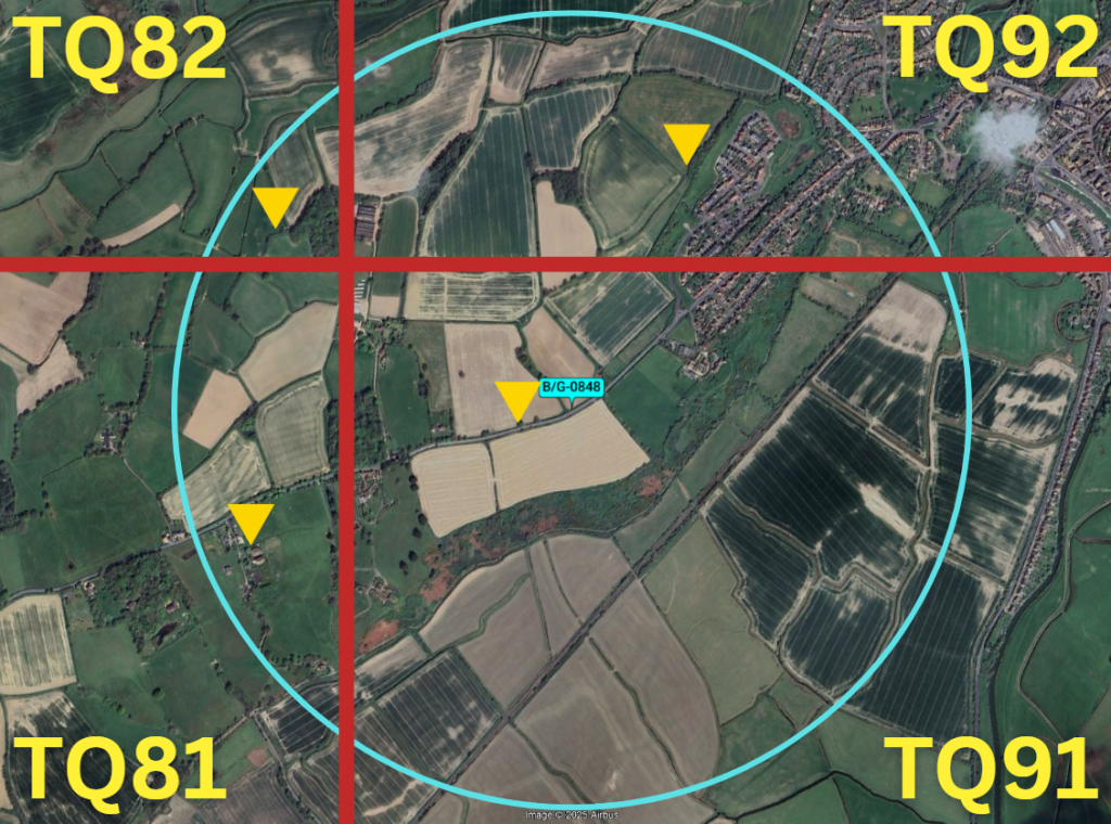
This images below (Google Earth) illustrate the challenge regarding WAB squares!

The image is centred on B/G-0848 (the ROC Post at Rye Harbour on the South Coast).

As can be seen the activation zone (blue 1000m radius circle) covers 4 WAB squares: The bunker is listed at TQ91, but the activator could be in TQ82, TQ92, TQ81 or TQ91 (as shown by the 4 yellow triangle examples).

ℹ️ For information related to WAB Squares and awards we recommend a visit to their website here.

(C) United Kingdom Bunkers on the Air (UKBOTA) 2025